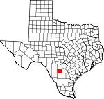
Frio County, Texas Basics:


Frio County Texas - Government Site

Population: 17,776
Area: 1134 square miles
County seat: Pearsall
Area code(s) in use: 830
Time zone: CST
High school graduate or higher: 62.8%
Bachelor's degree or higher: 8.2%
Median household income: $38,161
Persons in poverty: 22.8%
Home ownership rate: 66.3%
Mean travel time to work: 19.6 minutes


Adjacent counties:
Atascosa  Dimmit  La Salle  McMullen  Medina  Uvalde  Zavala  

Find in Texas

Map of the Frio County area


Our detail map of Frio County shows the Frio County, Texas boundary lines and other interesting items.

Places in Frio County, Texas

  Airports     show all on map

Agricultural Supplies Airport, Dilley Airpark, Jay Kay Ranch Airport, Mc Donald Ranch Airport, Mc Kinley Field Airport, Nash Ranch Airport

  Buildings     show all on map

Big Foot Wallace Museum, Dilley Public Library, Dilley Volunteer Fire Department, Frio County Courthouse, Frio County Emergency Medical Services, Frio Pioneer Jail Museum, Old Frio County Jail, Pearsall Public Library, Pearsall Volunteer Fire Department, South Texas Detention Complex, Texas Department of Criminal Justice Region 4 Dolph Briscoe Unit

  Cemeteries     show all on map

Brummett Cemetery, Buckhorn Cemetery, Covey Chapel Cemetery, Derby Cemetery, Diller Cemetery, Frio Town Cemetery, Hugo Cemetery, Longview Cemetery, Miguel Cemetery, Moore Cemetery, Moore Cemetery, Pearsall Cemetery

  Census     show all on map

Bigfoot Census Designated Place, Hilltop Census Designated Place, Moore Census Designated Place, North Pearsall Census Designated Place, West Pearsall Census Designated Place (historical)

  Churches     show all on map

Baptist Church First Baptist Church, Catholic Church, Pearsall Presbyterian Church, Presbyterian Church, Saint Mary Chapel, Saint Peter Lutheran Church

  Dams     show all on map

Burns Reservoir Dam, County Line Tank Dam, Cox Reservoir Dam, Derby Dam, Eschenburg Lake Dam, Holcomb Reservoir Dam, Kyote Lake Dam, Miracle Lake Dam, Morrow Dam Number 3, Morrow Dam Number 4, Morrow Lake Number 1 Dam, Morrow Lake Number 2 Dam, Sirrianni Lake Dam, Thompson Lake Dam, Triple S Lake Number 1 Dam, Triple S Lake Number 2 Dam, Vincent Lake Dam

  Hospitals     show all on map

Community General Hospital of Dilley Texas, Frio Regional Hospital, O'Conner Clinic

  Lakes     show all on map

Buzzard Roost Lake, Howard Lake, Jewel Lake

  Locales     show all on map

Abispa Windmill, Arrowhead Windmill, Barrel Windmill, Beef Trap Windmill, Berry Creek Windmill, Bob Smith Windmill, Briggs Windmill, Brushy Windmill, Brushy Windmill, Buzzard Roost Windmill, Caballo Blanco Windmill, Caldwell Windmill, Cattail Windmill, Chain Windmill, Chivo Windmill, Cocklebur Windmill, Cow Pasture Windmill, Crawford Windmill, Creek Windmill, Cude Windmill, El Rancho Quien Sabe, Forest Windmill, Frio Windmill, Gillman Windmill, Gracey Ranch, H and B Ranch, Halff Ranch, Headquarters Windmill, Herbert Windmill, Hill Windmill, Hill Windmill, Honeymoon Windmill, Hunters Camp Windmill, Javalin Windmill, Javelin Windmill, Jesse Windmill, Jewel Lake Windmill, Jim and Roy Windmill, John Gray Windmill, Johnson Ranch Windmill, Keystone Ranch, Lazy S Windmill, Little Field Windmill, Little Steel Windmill, Live Oak Windmill, Loston Windmill, Mare Trap Windmill, Martha Windmill, Midway Windmill, North Windmill, Number Five Windmill, Number Three Windmill, Oil Field Windmill, Panhandle Windmill, Panic Field Windmill, Penn Windmill, Prairie Windmill, Pranglin Windmill, Rancho Pobre, Red Windmill, Rio Frio Ranch, Robledo Windmill, Rock House Ranch, Rockhole Windmill, Round Mountain Windmill, Ruiz Windmill, Sally Windmill, Salty Windmill, San Jose Ranch, Shiner Ranch, Shiner Windmill, Shipping Trap Windmill, Sing Windmill, Slaughter Windmill, Spur Windmill, Stoker Ranch, Stub Windmill, T J Windmill, Tacho Windmill, Texaco Number One Windmill, Texaco Number Two Windmill, Thompson Ranch, Thompson Windmill, Timber Lake Windmill, Tooley Windmill, Tortuga Windmill, Triangle Windmill, Twin Windmills, Upper Brushy Windmill, Upper Brushy Windmill, West Slough Windmill, Winter Garden Rodeo Ground, Zartuche Windmill

  Oilfields     show all on map

Bigfoot Oil Field, Pearsall Oil Field, West Big Foot Gas Field, West Charlotte Oil Field

  Parks     show all on map

Dilley City Park, Firemans Park, Gosch Athletic Field, Longhorn Athletic Field

  Populated Places     show all on map

Alta Vista Colonia, Big Foot Colonia, Bigfoot, Cude Crossing Windmill, Derby, Derby Colonia, Dilley, Divot, Frio Heights Colonia, Frio Town, Goldfinch, Hilltop, Hilltop Colonia, Las Flores, Melon, Miguel, Moore, North Pearsall, Orelia, Parks Corner Windmill, Pearsall, Pearsall East Colonia, Schattel, West Pearsall

  Post Offices     show all on map

Bigfoot Post Office, Dilley Post Office, Moore Post Office, Pearsall Post Office

  Reservoirs     show all on map

Bar-One Tank, Bennett Reservoir, Buck Tank, Burns Reservoir, Caldwell Tank, Chapote Tank, Chivo Tank, Costilla Tank, County Line Tank, Cox Reservoir, Cude Tank, Devils Tank, Dove Tank, English Hills Tank, Eschenburg Lake, Fish Tank, Garden Tank, Harry Tank, Hill Tank, Hog Tank, Holcomb Reservoir, Javalin Tank, Kyote Lake, Leona Tank, Live Oak Tank, Live Oak Tank, Llave Tank, Miracle Lake, Morrow Lake Number 1, Morrow Lake Number 2, Morrow Lake Number 3, Morrow Lake Number 4, Muchacho Tank, Pancho Tank, Salt Hollow Tank, Sirrianni Lake, Thompson Lake, Triple S Lake Number 1, Triple S Lake Number 2, Tutiga Tank, Vincent Lake, Willow Tank

  Schools     show all on map

Bigfoot Alternative High School, Dilley Elementary School, Dilley High School, Mary Harper Middle School, Pearsall High School, Pearsall Intermediate School, Pearsall Junior High School, Ted Flores Elementary School, Westside School

  Streams     show all on map

Becerro Creek, Berry Creek, Big Hollow Creek, Big Slough, Big Slough, Black Creek, Buck Creek, Buckhorn Creek, Calf Creek, Cat Creek, Cattail Creek, Cocklebur Creek, Elm Creek, Elm Creek, Elm Creek, Goat Hollow Creek, Hackberry Creek, Hondo Creek, Horse Creek, Jack Creek, Leona River, Little Calf Creek, Live Oak Creek, Live Oak Creek, Live Oak Creek, Live Oak Creek, Lockhardt Creek, Mustang Creek, Siestedero Branch Creek, Smith Branch, Snake Creek, Tehuacana Creek, Todos Santos Creek, West Clear Creek, Yoledigo Creek

  Summits     show all on map

Abbey Hill, English Hills, Ghost Hill, Johnnie Little Hill, Jones Mound, Marshall Hills, Pilot Knob

  Towers     show all on map

KVWG-AM (Pearsall), KVWG-FM (Pearsall)

  Valleys     show all on map

Big Hollow, Moore Hollow, Mustang Hollow, Panther Hollow, Sand Hollow,

Frio County, Texas Population By Race (2012 estimate)

RacePopulation
WhiteFrio County White population 16,37216,371  
BlackFrio County Black population 693693
AsianFrio County Asian population 409408
MixedFrio County Mixed population 160159
American IndianFrio County American Indian population 142142
Hawaiian & Pacific IslanderFrio County Hawaiian & Pacific Islander population 00

Additional population tables :
State population table
Texas population by county