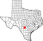
Medina County, Texas Basics:


Medina County Texas - Government Site

Population: 46,871
Area: 1325 square miles
County seat: Hondo
Area code(s) in use: 830
Time zone: CST
High school graduate or higher: 80.3%
Bachelor's degree or higher: 19.4%
Median household income: $52,206
Persons in poverty: 17.9%
Home ownership rate: 77.0%
Mean travel time to work: 31.2 minutes


Adjacent counties:
Atascosa  Bandera  Bexar  Frio  Uvalde  Zavala  

Find in Texas

Map of the Medina County area


Our detail map of Medina County shows the Medina County, Texas boundary lines and other interesting items.

Places in Medina County, Texas

  Airports     show all on map

Castroville Municipal Airport, Devine Municipal Airport, Glasscock Field Airport, Haass Field Airport, Hondo Municipal Airport, Lytle Airpark, Masterson Heliport, Squirrel Creek Ranch Airport, T-Ranch Airport, Weiblen Airport

  Bays     show all on map

Cherry Cove, Cypress Cove, Devils Kitchen, Habys Cove, Milligan Cove, Red Cove, Reuters Cove, Sawmill Cove, Seekatz Cove

  Buildings     show all on map

Castroville Public Library, Castroville Volunteer Fire Department, Charles de Montel House, Community Emergency Medical Service, D'hanis Volunteer Fire Department, Devine Emergency Medical Service, Devine Opera House, Devine Volunteer Fire Department, Driscoll Public Library, Hondo Public Library, Hondo Volunteer Fire Department Station 1, Hondo Volunteer Fire Department Station 2, La Coste Volunteer Fire Department, Landmark Inn Complex, Medina County Courthouse, Medina County Jail, Medina Lake Volunteer Fire Department Station 2, Medina Valley Emergency Medical Service, Mico Volunteer Fire Department Base Station, Natalia Volunteer Fire Department, Raye Theater, Saathoff House, Texas Department of Criminal Justice Region 4 Joe Ney State Jail, Texas Department of Criminal Justice Region 4 Ruben M Torres Unit, Yancey Volunteer Fire Department

  Canals     show all on map

Medina Irrigation Canal, Natalia Canal

  Capes     show all on map

Carters Point, Masterson Point, Point Comfort

  Cemeteries     show all on map

Britsch Cemetery, Butts Cemetery, Cortez Cemetery, Cottonwood Cemetery, Decker Cemetery, Evergreen Cemetery, Griffin Cemetery, Holy Cross Cemetery, Ingleside Cemetery, Miller Cemetery, Moore Cemetery, Mussman Cemetery, Oakwood Cemetery, Quihi Cemetery, Roberson Cemetery, Rothe Cemetery, Saint Dominic Cemetery, Saint Johns Cemetery, Saint Josephs Cemetery, Saint Louis Cemetery, Styles Cemetery, Tehuacana Cemetery, Tomerlin Cemetery, Yancey Cemetery, Zion Cemetery

  Census     show all on map

D'Hanis Census Designated Place

  Churches     show all on map

Betania Baptist Mission Church, Bethel Assembly of God Church, Black Creek Church, Church of Christ, First Mexican Baptist Church, Primitive Church, Rose Hill Church of Christ, Saint Francis Chapel, Saint Pauls Lutheran Church, West End Baptist Church

  Cliffs     show all on map

Barnes Bluff, Devils Bluff, Eagle Bluff, Mormon Bluff

  Dams     show all on map

Bader Lake Dam, Chicon Lake Dam, Collins Lake Dam, Farley Lake Dam, Faseler Lake Dam, Gabe Lake Dam, George Wilson Lake Number 1 Dam, George Wilson Lake Number 2 Dam, Goeth Lake Dam, Jones Lake Dam, Leinweber Lake Dam, McWilliams and Wimberley Development Corporation Dam, Medina Dam, Medina Diversion Lake Dam, Middle Verde Recharge Dam, Mumme Lake Dam, New Langford Lake Dam, Peacock Lake Dam, Primos Lake Dam, Richardson Lake Dam, San Geronimo Recharge Dam, Schuchart Lake Dam, Soil Conservation Service Site 11 Dam, Texas No Name Number 3 Dam, Texas No Name Number 4 Dam, Texas No Name Number 5 Dam, Twin Lake Estates-East Lake Dam, Twin Lake Estates-West Lake Dam, Wilson Lake Dam

  Hospitals     show all on map

Medina Community Hospital

  Islands     show all on map

Walton Island

  Lakes     show all on map

Barnes Bluff Waterhole, Blue Waterhole, Chacowalla Water Hole, Comanche Waterhole, King Waterhole, Mustang Waterhole, Two Pecan Waterhole, Wide Crossing Waterhole

  Locales     show all on map

Adams Ranch, Camp Mary Louise, Castroville Historic District, Cliff, D'Hanis Historic District, Gallagher Ranch, Hidden Valley Ranch, Hood Ranch, Howard Cemetery, Medina Lake State Fish Hatchery, River Windmill, West Windmill, Wilson Ranch, Windmill Number Fourteen

  Military     show all on map

Hondo Air Base (historical), Hondo Army Air Field (historical)

  Mines     show all on map

Geronimo Creek Quarry

  Oilfields     show all on map

Adams Oil Field, Bear Creek Oil Field, Taylor-Ina Oil Field

  Parks     show all on map

Barry Field, Colonial Oaks Park, Devine City Park, Hill Country State Natural Area, Hondo City Park, Koenig Park, Landmark Inn State Historical Park, Regional Park

  Populated Places     show all on map

Bader, Biry, Castroville, Cliff (historical), Coal Mine, D'Hanis, Devine, Dunlay, Flatrock Crossing, Hondo, La Coste, Mico, Natalia, New Fountain, Noonan, Pearson, Quihi, Riomedina, Valdina Farms, Yancey

  Post Offices     show all on map

Castroville Post Office, D'Hanis Post Office, Devine Post Office, Hondo Post Office, LaCoste Post Office, Natalia Post Office, Rio Medina Post Office, Yancey Post Office

  Reservoirs     show all on map

Bader Lake, Black Tank, Chacon Reservoir, Chicon Lake, Collins Lake, Diversion Lake, Farley Lake, Faseler Lake, Gabe Lake, George Wilson Lake Number 1, George Wilson Lake Number 2, Goeth Lake, Gross Tank, Jones Lake, Jungman Lake, Leinweber Lake, McWilliams and Wimberley Development Corporation Reservoir, Middle Verde Recharge Lake, Mumme Lake, Mustang Tank, New Langford Lake, Nunley Lake Number 2, Peacock Lake, Primos Lake, Richardson Lake, Ruby Lake, San Geronimo Recharge Lake, Schuchart Lake, Soil Conservation Service Site 11 Reservoir, Wilson Lake

  Schools     show all on map

Bigfoot Alternative Learning School, Biry School, D'hanis School, Devine High School, Devine Intermediate School, Devine Middle School, Hondo High School, John J Ciavarra Elementary School, Lacy School, Maverick School, McDowell Junior High School, Medina Valley Alternative Learning Center, Medina Valley Elementary School, Medina Valley High School, Medina Valley Intermediate School, Medina Valley Junior High School, Medina Valley School, Meyer Elementary School, Meyer School, Murphy School, Natalia Early Child Center, Natalia Elementary School, Natalia High School, Natalia Junior High School, Our Lady of Grace School, Saint John School

  Springs     show all on map

Bear Spring, Bear Spring, Campground Spring, Cedar Springs, Cherry Spring, Cypress Creek Spring, Diversion Dam Springs, Haby 1 Springs, Haby 2 Springs, Honeymoon Spring, Indian Mound Springs, Indian Spring, Middle Spring, Moccasin Spring, Pecan Grove Spring, Pecan Spring, Pecan Spring, Richter Spring, Sheep Spring, Twin Springs, Yellow Spring

  Streams     show all on map

Bandera Creek, Bear Creek, Bear Spring Creek, Bee Creek, Big Sous Creek, Brier Branch, Bull Creek, Burnt Boot Creek, Cascade Creek, Cedar Creek, Chacon Creek, Cherry Creek, Cow Creek, Cypress Creek, Deep Creek, Dripping Spring Creek, East Branch Live Oak Creek, East Prong Fort Ewell Creek, East Squirrel Creek, East Tehuacana Creek, East Verde Creek, Elm Creek, Elm Creek, Elm Slough, First Creek, Flat Creek, Fort Ewell Creek, Goose Creek, Hexa Creek, Hog Wallow Slough, Indian Spring Creek, Kempf Creek, Koenig Creek, Limekiln Creek, Little Comanche Creek, Little Live Oak Creek, Little Seco Creek, Little Sous Creek, Live Oak Creek, Live Oak Creek, Main Quihi Creek, Martin Creek, Mesquite Creek, Mexican Creek, Middle Verde Creek, Mustang Creek, Opossum Creek, Parkers Creek, Parkers Creek, Polecat Creek, Quihi Creek, Rocky Creek, San Francisco Perez Creek, San Geronimo Creek, Seco Creek, Second Creek, Sherer Creek, Smith Creek, Springs Creek, Squirrel Creek, Timber Creek, Verde Creek, Wards Creek, Water Creek, West Branch Live Oak Creek, West Prong Atascosa River, West Prong Fort Ewell Creek, West Squirrel Creek, West Tehuacana Creek, West Verde Creek, Yellow Creek

  Summits     show all on map

Blue Heaven, California Hill, Cedar Hill, Chimney Hill, Clousley Hill, Dan Hill, Flag Mountain, Flea Hill, Fohn Hill, Indian Hill, Loma Alta, One Horn Mountain, Red Hill, Rhins Hill, Round Mountain, Saathoff Mountain, Schmidt Hill, Split Mountain, Split Mountain, Texas Mountain, Turks Head

  Towers     show all on map

KKYX-AM (San Antonio), KRBH-FM (Hondo), KRME-AM (Hondo), KTXX-FM (Devine)

  Valleys     show all on map

Antone Hollow, Cherry Hollow, Deadman Hollow, Hay Hollow, Henderson Hollow, Long Hollow, Mustang Valley, Ney Hollow, Pigpen Hollow, Polecat Hollow, Through Hollow, Turkey Hollow, Twin Hollow, Vat Hollow, Water Canyon

  Wells     show all on map

High Lonesome Well,

Medina County, Texas Population By Race (2012 estimate)

RacePopulation
WhiteMedina County White population 44,19944,199  
BlackMedina County Black population 1,2191,218
MixedMedina County Mixed population 562562
American IndianMedina County American Indian population 469468
AsianMedina County Asian population 375374
Hawaiian & Pacific IslanderMedina County Hawaiian & Pacific Islander population 4746

Additional population tables :
State population table
Texas population by county