Goliad County, Texas Basics:


Goliad County Texas - Government Site

Population: 7,346
Area: 852 square miles
County seat: Goliad
Area code(s) in use: 361
Time zone: CST
High school graduate or higher: 83.7%
Bachelor's degree or higher: 13.6%
Median household income: $50,635
Persons in poverty: 14.6%
Home ownership rate: 78.6%
Mean travel time to work: 30.3 minutes

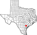
Adjacent counties:
Bee  Dewitt  Karnes  Refugio  Victoria  

Find in Texas

Map of the Goliad County area


Our detail map of Goliad County shows the Goliad County, Texas boundary lines and other interesting items.

Places in Goliad County, Texas

  Airports     show all on map

Navy Outlying Field (NOLF) Goliad Airport

  Bends     show all on map

Hovey Bend, McKinney Bend

  Bridges     show all on map

Duke Bridge

  Buildings     show all on map

Ander - Weser Volunteer Fire Department, Captain Barton Peck House, Charles H and Catherine B Baker House, Doctor LW and Martha ES Chilton House, Goliad County Courthouse, Goliad County Emergency Medical Services, Goliad County Jail, Goliad County Library, Goliad County Sheriff's Office, Goliad Volunteer Fire Department, Jessie W Stoddard House, Market House Museum, Old Market House Museum, Presidio la Bahia Museum, Schroeder Volunteer Fire Department, Weesatche Volunteer Fire Department, Zaragoza Birthplace

  Capes     show all on map

Hall Point

  Cemeteries     show all on map

Barnes Cemetery, Berger Cemetery, Charco Cemetery, Danforth Cemetery, Fannin Cemetery, Flores Cemetery, Franklin Cemetery, Glendale Cemetery, John Pettus Cemetery, Killibrew Cemetery, Lott Cemetery, Lott Cemetery, Lott Pettus Cemetery, McGuill Cemetery, Mistletoe Cemetery, Mucorrera Cemetery, Myers Cemetery, Noble Cemetery, Rubio Cristo Rey Cemetery, San Antonio Cemetery, San Jasinto Cemetery, San Jose Cemetery, Sarco Cemetery, Sepenter Cemetery, Wisbey Cemetery, Woodlawn Cemetery

  Churches     show all on map

Mallahau Church, Minnehulla Church, Mission Espiritu Santo, Mount Moriah Baptist Church, Saint Andrews Church, Saint Lukes Church, Zion Hill Church

  Dams     show all on map

Dye Lake Dam, Hensley Lake Dam

  Lakes     show all on map

Bundick Lake, Flat Lake, Fulcrod Lake, Gibson Lake, Hackberry Lake, Hardaman Lake, Horseshoe Lake, Live Oak Lake, Lott Lake, Milinda Lake, Onderdunk Lake, Redding Lake, Rice Lake

  Locales     show all on map

Airfield Windmill, Bissitt Ranch, Bissitt Windmill, Brahman Windmill, Byrnes Windmill, Clip Ranch, Coyote Windmill, Dial Ranch, Dutch Trap Windmill, Elkins Windmill, Farley Windmill, Gin Windmill, Goliad County Courthouse Historic District, Henke Windmill, Irby Ranch, Lake Windmill, Lake Windmill, Lazy F Ranch, Little Sarco Windmill, Lott Windmill, Lower Buzzard Windmill, Matt Windmill, Melo Ranch, Mission Nuestra Senora del Rosario, Mulley Windmill, Number Four Windmill, Number One Windmill, Number Three Windmill, Number Two Windmill, Old Vat Windmill, Placedo Windmill, Presidio La Bahia, Presidio Nuestra Senora de Loreto de la Bahia, Ramirez Windmill, Red Windmill, River Ranch, River Windmill, Samson Windmill, Spangle Windmill, Swickheimer Ranch, Upper Buzzard Windmill, Winter Windmill, Woods Windmill

  Oilfields     show all on map

Albrecht Gas Field, Alkek Oil Field, Barvo Oil Field, Battle Oil Field, Boyce Oil Field, Brandt Oil Field, Cabeza Creek Oil Field, Charco Southeast Gas Field, Dallas-Husky Gas Field, Dial Gas Field, Fannin East Oil Field, Gottschalt Gas Field, Hordes Creek Gas Field, Marshall Gas Field, Matze Oil Field, Mission Valley West Gas Field, North Fannin Gas Field, Poehler Gas Field, Sarco Creek Gas Field, Slick Oil Field, Terrell Point Oil Field, Weesatche Gas Field, Yanta Gas Field

  Parks     show all on map

Coleto Creek Regional Park, Fannin State Park, Goliad County Fairgound, Goliad State Park

  Populated Places     show all on map

Ander, Angel City, Berclair, Charco, Cologne, Fannin, Goliad, Kilgore, Melo, Melrose, O'Donnell Place, Riverdale, Sarco, Schroeder, Scurlock, Weesatche, Weser

  Post Offices     show all on map

Berclair Post Office, Goliad Post Office, Weesatche Post Office

  Reservoirs     show all on map

Coleto Creek Cooling Pond, Dye Lake, Hensley Lake, Kilgore Tank

  Schools     show all on map

Goliad Elementary School, Goliad High School, Goliad High School, Goliad Middle School

  Streams     show all on map

Alligator Creek, Arroyocita Creek, Blue Branch, Buzzard Branch, Cabeza Creek, Cadena Creek, Charco Creek, Chicken Creek, Cow Creek, Dry Creek, Dry Creek, Dry Creek, Eighteenmile Creek, Elkins Branch, Farmer Creek, Fifteenmile Creek, Goat Creek, Goat Creek, Gobbler Creek, Hog Creek, Hog Thief Creek, Hord Creek, Indian Creek, Kilgore Creek, Little Sarco Creek, Live Oak Creek, Lost Creek, Manahuilla Creek, Martinez Creek, Milby Creek, Millers Creek, Mucorrera Creek, Mud Creek, Payton Branch, Perdido Creek, Peters Creek, Road Creek, Salt Creek, Sarco Creek, Sulphur Creek, Turkey Creek

  Trails     show all on map

Aranama Trail, Coleto Creek Park Hiking Trail, Goliad State Park Trail

  Valleys     show all on map

Keys Hollow, Portis Draw, Portis Draw, Post Oak Hollow, Sand Hollow, Wade Reeves Hollow, Whaley Hollow,

Goliad County, Texas Population By Race (2012 estimate)

RacePopulation
WhiteGoliad County White population 6,7806,780  
BlackGoliad County Black population 389389
MixedGoliad County Mixed population 8180
American IndianGoliad County American Indian population 7373
AsianGoliad County Asian population 2222
Hawaiian & Pacific IslanderGoliad County Hawaiian & Pacific Islander population 00

Additional population tables :
State population table
Texas population by county