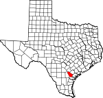
Bee County, Texas Basics:
Bee County Texas - Government Site
Population: 32,501
Area: 880 square miles
County seat: Beeville
Area code(s) in use: 361
Time zone: CST
High school graduate or higher: 70.6%
Bachelor's degree or higher: 8.5%
Median household income: $40,707
Persons in poverty: 23.0%
Home ownership rate: 64.7%
Mean travel time to work: 23.9 minutes
Adjacent counties:
Goliad Karnes Live Oak Refugio San Patricio
Places in Bee County, Texas
Beeville Municipal Airport,
Brown Ranch Airport,
Chase Field Industrial Airport,
Meyer Ranch Airport Medio Creek Bridge Angel Care Ambulance Service,
Bee County Constable's Office Precinct 2,
Bee County Constable's Office Precinct 3,
Bee County Constable's Office Precincts 1 and 4,
Bee County Courthouse,
Bee County Public Library,
Bee County Sheriff's Office,
Beeville Art Museum,
Beeville Police Community Training Center,
Beeville Police Department,
Beeville Volunteer Fire Department,
Blanconia Volunteer Fire Department,
Papalote Volunteer Fire Department,
Pettus - Tuleta Volunteer Fire Department First Responders,
Praeger Building,
Skidmore Fire Department,
Skidmore Historical Society Museum,
Skidmore Volunteer Fire Department,
South Texas Childrens Home,
Texas Department of Criminal Justice Region 4 Garza East Transfer Facility,
Texas Department of Criminal Justice Region 4 Garza West Transfer Facility,
Texas Department of Criminal Justice Region 4 William G McConnell Unit,
Tynan Volunteer Fire Department Beeville Memorial Park,
Campo Santo Cemetery,
Cementerio Evangelico,
Colony Cemetery,
Dahl Cemetery,
Evergreen Cemetery,
Evergreen Cemetery,
Gleenwood Cemetery,
Mineral Cemetery,
Normanna Cemetery,
Old Papalote Cemetery,
Our Lady of Victory Cemetery,
Our Lady of Victory Number 2 Cemetery,
Papalote Cemetery,
Pawnee Cemetery,
Pettus Cemetery,
Pullin-Livingston Cemetery,
Saint Joseph Cemetery,
Saint Rose Cemetery,
San Pedro Cemetery,
Waldheim Cemetery,
Wernli Cemetery Blue Berry Hill Census Designated Place,
Normanna Census Designated Place,
Pawnee Census Designated Place,
Pettus Census Designated Place,
Skidmore Census Designated Place,
Tuleta Census Designated Place,
Tulsita Census Designated Place,
Tynan Census Designated Place Adams Saint Church of Christ,
Bethel Pentecostal Church,
Bible Baptist Church,
Church of Christ East Side,
El Buen Pastor Baptist Church,
First Presbyterian Church,
Friendship Church,
Jones Chapel Methodist Church,
Primera Iglesia Bautista Church,
Saint Philips Episcopal Church,
Seventh Day Adventist Church,
United Pentecostal Church Christ Temple Dougherty Reservoir Dam CHRISTUS Spohn Hospital - Beeville Corrigan Hole Beeville Country Club,
Hall Ranch,
San Domingo Ranch,
The Devil Tree Blanconia Oil Field,
Caesar Oil Field,
Cannan Oil Field,
Cosden West Oil Field,
Dirks Oil Field,
Goree Oil Field,
Holzmark Oil Field,
Maley Oil Field,
Mineral Gas Field,
Normanna Gas Field,
Papalote Oil Field,
Pettus North Oil Field,
Pettus Oil Field,
Plummer Oil Field,
Ray Oil Field,
San Domingo Oil Field,
South Blanconia Oil Field,
Tulsita Oil Field,
West Tuleta Oil Field,
Yoward Oil Field Alta Vista Park,
Ann Burke Park,
Beeville City Park,
Flournoy Park,
Kobler Park,
Northwest Area Park,
Poesta Park,
Reyes Park,
Ten Acre Park,
Veterans Memorial Park 1st, 2nd, and 3rd Street Area Colonia,
Beeville,
Blanconia,
Blue Berry Hill,
Blue Berry Hill Colonia,
Cadiz,
Caesar,
Clareville, Corrigan Settlement (historical),
Hidden Acres Colonia,
Mineral,
Monteola,
Normanna,
Oaks,
Old Airport Road Colonia,
Old Houston Highway Colonia,
Olmos,
Orangedale,
Papalote,
Pawnee,
Pettus,
River Oaks Number 2 Colonia,
Salazar Heights Colonia,
Skidmore,
Tuleta,
Tulsita,
Tynan,
Yougeen Beeville Post Office,
Normanna Post Office,
Pawnee Post Office,
Pettus Post Office,
Skidmore Post Office,
Tuleta Post Office,
Tynan Post Office Dougherty Reservoir Burkes Ridge A C Jones High School,
Beeville School District Learning Resource Center,
Coastal Bend College,
Conoly Alternative School, Fadden - McKeown Elementary School,
First Baptist Church School,
Hall School,
Jackson School,
Madderra - Flournoy Elementary School,
Moreno Junior High School,
Our Lady of Victory School, Pawnee Elementary and Junior High School, Pettus Elementary School,
Pettus Elementary School, Pettus High School,
Pettus High School,
R A Hall Elementary School,
Saint Mary Academy Charter School,
Saint Philip's Episcopal School, Skidmore - Tynan Elementary School,
Skidmore - Tynan Elementary School, Skidmore - Tynan High School,
Skidmore - Tynan High School, Skidmore - Tynan Junior High School,
Skidmore - Tynan Junior High School,
Texas A and M University Agricultural Research Station,
Thomas Jefferson Intermediate School,
Thomas Jefferson Junior High School,
Tyler Elementary School Aransas Springs, Corrigan Hole Spring, Papalote Springs, Pecan Water Hole Spring (historical), Rock Water Hole Spring (historical)
Aransas Creek,
Blackjack Creek,
Boggy Creek,
Boggy Creek,
Bullshead Creek,
Dry Creek,
Dry Medio Creek,
Elm Creek,
Elm Creek,
Little Dry Creek,
Murphy Creek,
Neddy Creek,
Olmos Creek,
Parker Hollow Creek,
Poesta Creek,
Ratta Creek,
Salt Branch,
San Domingo Creek,
Silver Creek,
Spring Creek,
Talpacate Creek,
Toro Creek KIBL-AM (Beeville),
KIBL-FM (Beeville),
KYTX-FM (Beeville) Burk Hollow,
Live Oak Hollow,
McFall Draw,
Moss Gully,
Panther Hollow,

