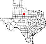
Haskell County, Texas Basics:


Haskell County Texas - Government Site

Population: 5,871
Area: 903 square miles
County seat: Haskell
Area code(s) in use: 940
Time zone: CST
High school graduate or higher: 77.8%
Bachelor's degree or higher: 14.8%
Median household income: $40,247
Persons in poverty: 19.7%
Home ownership rate: 72.7%
Mean travel time to work: 16.0 minutes


Adjacent counties:
Baylor  Jones  King  Knox  Shackelford  Stonewall  Throckmorton  

Find in Texas

Map of the Haskell County area


Our detail map of Haskell County shows the Haskell County, Texas boundary lines and other interesting items.

Places in Haskell County, Texas

  Airports     show all on map

Haskell Municipal Airport

  Areas     show all on map

Weinert Oil Field

  Buildings     show all on map

Fields Museum, Haskell County Ambulance Service, Haskell County Library, Haskell Volunteer Fire Department, Paint Creek Volunteer Fire Department, Rochester Fire Department, Weinert Volunteer Fire Department

  Cemeteries     show all on map

Brushy Cemetery, Capron Cemetery, Highland Cemetery, Howard Cemetery, Idella Cemetery, Pinkerton Cemetery, Pleasant Valley Cemetery, Roberts Cemetery, Rochester Cemetery, Rockdale Cemetery, Rule Cemetery, Stamford Cemetery, Weinert Cemetery, Willow Cemetery

  Churches     show all on map

Church of Christ, Church of God, First Baptist Church, First Presbyterian Church, Greater Independent Baptist Church, Lindsay Chapel, Rockdale Church

  Dams     show all on map

Bettis Lake Dam, Elm Creek Tank Dam, Harlan Weinert Lake Dam, Haskell Club Dam, Lake Stamford Dam, Pea Ridge Tank Dam

  Hospitals     show all on map

Haskell Memorial Hospital

  Lakes     show all on map

Griffin Lake, Hester Lake, Louis Lake, Mitchell Lake, Reid Lake, Russell Lake, Thompson Lake, Winchester Lake, Zahn Lake

  Locales     show all on map

Flat Top Ranch, West Camp

  Oilfields     show all on map

Haskell Oil Field, Jud Oil Field, Julian Oil Field, Sojourner Oil Field

  Parks     show all on map

Lake Stamford Park, Scott Memorial Park

  Populated Places     show all on map

Haskell, Irby, Josselet, Jud, Jud, Mattson, O'Brien, Paint Creek, Pinkerton, Plainview, Rochester, Rule, Sagerton, Scott Crossing, Vontress, Weinert

  Post Offices     show all on map

Haskell Post Office, O'Brien Post Office, Rochester Post Office, Rule Post Office, Weinert Post Office

  Reservoirs     show all on map

Bettis Lake, Bitter Lake, Country Club Lake, Elm Creek Tank, Harlan Weinert Lake, Johnson Lake, Lake Stamford, Pea Ridge Tank

  Schools     show all on map

Carney High School, Haskell Elementary School, Haskell High School, Paint Creek School, Rochester School, Rule School, Sagerton-Rule High School

  Springs     show all on map

Blue Hole Springs (historical), Buffalo Springs, Cook Springs, Gyp Springs, McGregor Springs, O J Spring, Rice Springs, Willow Pond Springs, Willow Springs

  Streams     show all on map

Brushy Creek, Buffalo Creek, California Creek, Dudleys Creek, Flat Paint Creek, Gyp Creek, Horse Creek, Little Timber Creek, Mule Creek, North Mule Creek, North Paint Creek, Red Creek, Red Paint Creek, Rice Springs Branch, Spring Creek, Stink Creek, Tonk Creek, Turkey Paint Creek, Wild Horse Creek, Willow Creek

  Towers     show all on map

KVRP-FM (Haskell),

Haskell County, Texas Population By Race (2012 estimate)

RacePopulation
WhiteHaskell County White population 5,4255,424  
BlackHaskell County Black population 264264
MixedHaskell County Mixed population 106105
American IndianHaskell County American Indian population 4746
AsianHaskell County Asian population 3535
Hawaiian & Pacific IslanderHaskell County Hawaiian & Pacific Islander population 00

Additional population tables :
State population table
Texas population by county