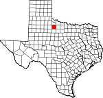
Knox County, Texas Basics:
Knox County Texas - Government Site
Population: 3,770
Area: 851 square miles
County seat: Benjamin
Area code(s) in use: 940
Time zone: CST
High school graduate or higher: 77.5%
Bachelor's degree or higher: 12.6%
Median household income: $33,667
Persons in poverty: 21.3%
Home ownership rate: 65.4%
Mean travel time to work: 14.9 minutes
Adjacent counties:
Baylor Foard Haskell King Stonewall Throckmorton
Places in Knox County, Texas
Harrison Field of Knox City Airport,
Munday Municipal Airport,
Munday Municipal Airport,
Oliver Airport Glover Bend State Highway 16 Bridge Benjamin Volunteer Fire Department,
Goree Volunteer Fire Department,
Knox City Fire Department,
Knox County Emergency Medical Services,
Knox County Jail,
Knox County Museum,
Munday Volunteer Fire Department Friendship Cemetery,
Goree Cemetery,
Johnson Memorial Cemetery,
Knox City Cemetery,
Old Goree Cemetery,
Truscott Cemetery Church of Christ,
Gillespie Church Boyd Lake Dam,
Clonts Lake Dam,
Crappie Tank Dam,
Horseshoe Tank Dam,
Kiowa Lake Dam,
Lake Benjamin Dam,
Lake Catharine Dam,
Lake Davis Dam,
Lyles Brothers Lake Dam,
Moorehouse Brothers Ranch Lake Dam,
Munday Park Dam Adams Flat,
Maverick Flat The Narrows Knox County Hospital China Lake,
Scott Lake Alexander Ranch,
Beavers Ranch,
Burnett Ranch,
Croton Windmill,
Deadman Windmill,
Driver Ranch,
Ellis Ranch,
Hamilton Ranch,
Knox City Country Club,
League Ranch,
Little Dick Windmill,
Lyles Ranch,
McFaddin Ranch,
Munday Country Club,
West End Windmill,
Williams Ranch Benjamin,
Gilliland,
Goree,
Hefner,
Knox City,
Munday,
Rhineland,
Sunset,
Truscott,
Union Grove,
Vera Benjamin Post Office,
Goree Post Office,
Knox City Post Office,
Munday Post Office Atkinson Tank,
Big Tank,
Boyd Lake,
Clonts Lake,
Coppermine Tank,
Cox Tank,
Crappie Tank,
Deep Tank,
Deer Tank,
Double Tanks,
Dragline Tank,
East Breaks Tank,
Flat Tank,
Glover Trap Tank,
Grass Field Tank,
Gravel Tank,
Gyp Creek Tank,
Hackberry Tank,
Highline Tank,
Horse Pasture Tank,
Horseshoe Tank,
Jackson Tank,
Jamison Tank,
Kiowa Lake,
Lake Benjamin,
Lake Catharine,
Lake Davis,
Little Grass Field Tank,
Long Trap Tanks,
Lyles Brothers Lake,
Moorehouse Brothers Ranch Lake,
Moss Tank,
Munday Park Lake,
North Double Tanks,
North Dutchman Tank,
North Patton Tank,
Parker Tank,
Quintana Tank,
Red Tank,
Rock Tank,
Sheep Section Tank,
Shipman Trap Tank,
South Jones Tank,
Truscott Brine Lake,
Van Earl Tank,
Waggoner Tank,
Ward Field Tank,
Ward Tank,
West McClain Tank,
West Side Tank,
White Tank Ignorant Ridge Benjamin School, Goree School, Knox City Elementary School, Knox City High School, Munday Elementary School, Munday High School, O'Brien Middle School
Big Four Springs (historical), Bluff Springs, Browder Spings (historical), Cedar Mountain Spring, Chalk Springs, China Springs (historical), Coltharp Springs, Craig Springs (historical), Cypress Springs, Grapevine Croton Spring, H Cross Springs (historical), Hash Knife Springs, Mansfield Springs, Mockingbird Springs, Naptha Spring, Redder Springs, Riley Springs (historical), Sheek Springs (historical), Speers Springs (historical), Trough Springs (historical), Turner Springs, W Cross Springs, Watkins Springs, Weatherly Spring, Wild Horse Springs
Black Top Creek,
Bluff Creek,
Buffalo Creek,
Bull Turner Creek,
China Branch,
China Creek,
Colwell Creek,
Deadman Creek,
Dutchman Creek,
Gyp Creek,
Gyp Creek,
Hackberry Creek,
Honey Creek,
Ilseng Creek,
Little Croton Creek,
Mustang Creek,
North Wichita River,
Red Creek,
Salt Creek,
Salt Flat Creek,
Sheep Creek,
Smelter Creek,
South Wichita River,
Union Creek,
Wild Horse Creek Bald Mountain,
Cedar Mountain Glover Canyon,
Little Getaway Canyon,
Panther Canyon,
Smelter Canyon,

