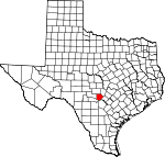
Kendall County, Texas Basics:


Kendall County Texas - Government Site

Population: 35,968
Area: 662 square miles
County seat: Boerne
Area code(s) in use: 830
Time zone: CST
High school graduate or higher: 90.4%
Bachelor's degree or higher: 38.8%
Median household income: $71,553
Persons in poverty: 8.0%
Home ownership rate: 75.7%
Mean travel time to work: 26.7 minutes


Adjacent counties:
Bandera  Bexar  Blanco  Comal  Gillespie  Kerr  

Find in Texas

Map of the Kendall County area


Our detail map of Kendall County shows the Kendall County, Texas boundary lines and other interesting items.

Places in Kendall County, Texas

  Airports     show all on map

B. J. Mc Combs Sisterdale Airport, Diamond K Ranch Airport, Double U Ranch Airport, Grier Airport, Headwaters Airport, John Henry Key Airport, Rust Field Airport, Wallace Ranch Airport

  Areas     show all on map

Texas-Gulf Region - 2-digit Hydrologic Unit Code - 12

  Buildings     show all on map

Agricultural Heritage Museum, Balcones Community Center, Boerne Library, Boerne Police Department, Boerne Public Library, Boerne Volunteer Fire Department, Boerne Wastewater Treatment Plant, Cibolo Nature Center, Comfort Historical Society, Comfort Public Library, Comfort Volunteer Fire Department, Electric Substation, Joseph Dienger Building, Kendalia Public Library, Kendalia Public Library, Kendalia Volunteer Fire Department, Kendall County Courthouse, Kendall County Emergency Medical Service, Kendall County Emergency Medical Service Substation, Kendall County EMS, Kendall County Law Enforcement Center, Kendall County Library System, Kendall Inn, Kulmann-King House, Otto Brinkmann House, Pleasant Valley Community Center, Sisterdale Community Center, Sisterdale Volunteer Fire Department, Waring Community Center, Waring Volunteer Fire Department

  Cemeteries     show all on map

Ammann Cemetery, Bergheim Cemetery, Beseler Cemetery, Brownsboro Cemetery, Charles Cole Cemetery, Cole - Hugman Cemetery, Comfort Cemetery, Dantziger Monument, Edge Cemetery, Gaddis Cemetery, Givens Cemetery, Herbst - Patton Cemetery, Howard Cemetery, Insall Cemetery, Jones Cemetery, Knuepper Cemetery, Kreutzberg Cemetery, Langridge Family Cemetery, Lawhon Cemetery, Lenz Cemetery, Richter Cemetery, Schmidt Cemetery, Short Cemetery, Steves Family Cemetery, Syring Cemetery, Treue der Union, Upper Cibolo Community Cemetery, Werner Cemetery, White Cemetery, Willke Cemetery, Wrenn Cemetery, Zoeller Cemetery

  Census     show all on map

Comfort Census Designated Place

  Churches     show all on map

Assembly of God Church, Baptist Church, Benedictine Convent, Camp Capers Church, Church of Christ, Currey Creek Baptist Church, First Baptist Church, First United Methodist Church, Jehovahs Witnesses of Boerne, Jesus Name Full Gospel Church, Kendalia Community Church, Saint Helenas Episcopal Church, Saint John Lutheran Church, Saint Johns Anglican Church, Saint Mark Presbyterian Church, Saint Peter the Apostle Catholic Church, The Church of Jesus Christ of Latter Day Saints, Waring Baptist Church

  Cliffs     show all on map

Gaddis Bluff

  Dams     show all on map

711 Ranch Lake Dam, Boerne State Park Dam, KWW Ranch Lake Number 1 Dam, Lake Oz Dam, Masters Lake Dam, Smith Investment Company Lake Number 1 Dam, Smith Investment Company Lake Number 3 Dam, Soil Conservation Service Site 1 Dam, Soil Conservation Service Site 2 Dam, Soil Conservation Service Site 3 Dam, Soil Conservation Service Site 4 Dam

  Falls     show all on map

Edge Falls

  Gaps     show all on map

Spanish Pass

  Locales     show all on map

Camp Alzafar, Camp Capers, Camp Idlewide, Comfort Historic District, Cothrum Ranch, Guadalupe River Ranch, Haag Ranch, Herff Park Fairground, Hillingdon Ranch, Jung Ranch, Lindendale Community Hall, Mount Alamo (historical), Offer Ranch, Rausch Ranch, Sycamore Ridge Camp, Turkey Hollow Ranch, Welfare, Whitworth Ranch

  Parks     show all on map

Boerne City Park, BYAA Merchant Field, James Kiehl River Bend Park, Old Tunnel Wildlife Management Area, Sisterdale Valley District, Treue Der Union Monument

  Populated Places     show all on map

Ammans Crossing, Bankersmith, Bergheim, Boerne, Comfort, Kendalia, Kreutzberg, Lindendale, Nelson City, Oberly Crossing, Sisterdale, Walnut Grove, Waring, Welfare

  Post Offices     show all on map

Bergheim Post Office, Boerne Post Office, Comfort Post Office, Kendalia Post Office, Sisterdale Post Office (historical), Waring Post Office

  Reservoirs     show all on map

711 Ranch Lake, Boerne Park Lake, KWW Ranch Lake Number 1, Lake Oz, Masters Lake, Smith Investment Company Lake Number 1, Smith Investment Company Lake Number 3, Soil Conservation Service Site 1 Reservoir, Soil Conservation Service Site 2 Reservoir, Soil Conservation Service Site 3 Reservoir, Soil Conservation Service Site 4 Reservoir

  Schools     show all on map

Boerne High School, Boerne Middle School, Boerne Middle School North, Boerne Middle School South, Comfort Elementary School, Comfort High School, Comfort Middle School, Curington Elementary School, Fabra Elementary School, Fair Oaks Ranch Elementary School, Kendall Elementary School, Panther Creek School (historical), Pleasant Valley School (historical)

  Springs     show all on map

Brown Spring, Carson Spring, Champee Spring, Comanche Spring, Coyote Spring, Delaware Spring, Edge Falls Springs, Neal Spring, Reed Spring, Sycamore Spring, Wenzel Spring, Whiskey Spring, Willow Spring, Wilson Spring

  Streams     show all on map

Allen Creek, Askey Creek, Balcones Creek, Bear Creek, Big Joshua Creek, Black Creek, Blackberry Creek, Block Creek, Browns Creek, Currey Creek, Cypress Creek, Darmstadt Creek, Deep Hollow Creek, Delaware Creek, Dry Creek, East Sister Creek, Easter Creek, Flat Rock Creek, Frederick Creek, Goss Creek, Haag Creek, Holliday Creek, Jacobs Creek, Joshua Creek, Jung Creek, Krause Creek, Little Joshua Creek, Manahan Creek, Meier Creek, Menger Creek, North Creek, Panther Creek, Platte Creek, Polecat Spring Creek, Possum Creek, Ranger Creek, Rawls Creek, Reeh Creek, Rock Creek, Ross Creek, Rundale Creek, Sabinas Creek, Sheps Creek, Simmons Creek, Sister Creek, Smith Creek, Soell Creek, South Fork Blanco River, Spring Creek, Swede Creek, Violet Creek, Walter Creek, Wasp Creek, Wenzel Creek, Werner Creek, West Sister Creek, Willie Creek, Zinke Creek

  Summits     show all on map

Big Hill, Bust Buttes, Cannon Hill, Cave Hill, Cedar Mountain, Dunners Mountain, Jungfrau, Lone Hill, Malakopf Hill, Meta Mountain, Mount Rigi, No Name Hills, Rattlesnake Mountain, Ring Mountain, Round Mountain, Sabinas Mountain, Schleicher Mountain, Smith Hill, Turkey Knob, Wolf Mountain

  Towers     show all on map

KBRN-AM (Boerne), KONO-FM (Fredericksburg)

  Trails     show all on map

Cibolo Nature Center Trail, Old Tunnel Wildlife Management Area Nature Trail

  Valleys     show all on map

Barker Hollow, Big Spring Canyon, Carlisle Canyon, Coffee Hollow, Coyote Canyon, Elm Bottom, Elm Hollow, First Coffee Hollow, Heiliqmann Canyon, Hog Hollow, Pleasant Valley, Rafter Hollow, Second Coffee Hollow, Sleepy Hollow, Spicewood Canyon, Thornton Canyon, Turkey Hollow,

Kendall County, Texas Population By Race (2012 estimate)

RacePopulation
WhiteKendall County White population 34,60134,601  
MixedKendall County Mixed population 504503
AsianKendall County Asian population 288287
American IndianKendall County American Indian population 252251
Hawaiian & Pacific IslanderKendall County Hawaiian & Pacific Islander population 3635

Additional population tables :
State population table
Texas population by county