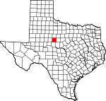
Taylor County, Texas Basics:


Taylor County Texas - Government Site

Population: 133,984
Area: 916 square miles
County seat: Abilene
Area code(s) in use: 325
Time zone: CST
High school graduate or higher: 85.3%
Bachelor's degree or higher: 24.2%
Median household income: $44,372
Persons in poverty: 17.0%
Home ownership rate: 61.9%
Mean travel time to work: 15.9 minutes


Adjacent counties:
Callahan  Coleman  Fisher  Jones  Nolan  Runnels  Shackelford  

Find in Texas

Map of the Taylor County area


Our detail map of Taylor County shows the Taylor County, Texas boundary lines and other interesting items.

Places in Taylor County, Texas

  Airports     show all on map

Abilene Regional Airport, Abilene Regional Medical Center Heliport, Dyess Air Force Base, Elmdale Airpark, Flying B Ranch Airstrip, Flying W Airport, Hendrick Medical Center Heliport, Sears Airport

  Basins     show all on map

Lytle Cove

  Buildings     show all on map

A T Jones House, Abilene and Northern Railway Company Depot, Abilene Christian University Administration Building, Abilene Federal Building, Abilene Fire Department Station 1, Abilene Fire Department Station 2, Abilene Fire Department Station 3, Abilene Fire Department Station 4, Abilene Fire Department Station 5, Abilene Fire Department Station 6, Abilene Fire Department Station 7, Abilene Fire Department Station 8, Abilene Fire Marshal's Office, Abilene Public Library, Abilene Public Library Pilot Branch, Abilene Street Railway Company Barn, Acadia Abilene, Air Evac Lifeteam, Albert S and Ruth Goodloe House, Alexander-Campbell House, Boyd-Hall House, Buffalo Gap Volunteer Fire Department, C A Lanius House, Caldwell Hall, Charles Motz House, D D Parramore House, David C and Docia Fritz House, David S Castle House, Dodd-Harkrider House, E D Williamson House, Ed S Hughes Company Warehouse, Elm Creek Citizens Association Volunteer Fire Department Station 1, Elm Creek Citizens Association Volunteer Fire Department Station 2, Eugene L Finley House, George R Davis House, George W and Lavina McDaniel House, Hamby Volunteer Fire Department, Hendrick Home for Children, Henry Sayles House, Hilton Hotel, Horace O Wooten Grocery Company Warehouse, Horace O Wooten House, J D Magee House, J G Higginbotham House, J W Evans House, James M Radford Grocery Company Warehouse, Jhules Reading House, Jim Ned Volunteer Fire Department, Lawn Fire Department, Luce Hall, McDonald Hall, McMurry College Administration Building, Merkel Emergency Medical Service, Merkel Volunteer Fire Department, MetroCare Services, Mulberry Canyon Volunteer Fire Department, Museums of Abilene, Myers Memorial Arena, Nathan J and Nancy Roberts House, O D and Ada Dillingham House, Old Taylor County Courthouse and Jail, Oscar P Thomas House, Paramount Theater, Potosi Volunteer Fire Department, Roland AD Green House, Samuel A Chambers House, Shades of Hope Rehabilitation Center, South Taylor Emergency Medical Service, Southwest Med Evac 3, Taylor County Courthouse, Taylor County Detention Center, Texas Forest Service Abilene Office, Thomas L Blanton House, Trent Volunteer Fire Department, Tuscola Fire Department, Tye Volunteer Fire Department, United States Weather Bureau Building, Universal Manufacturing Company Building, View Volunteer Fire Department, W A V Cash House, William A Minter House, William and Evla Stith House, William and Mary Ackers House, William and Shirley Swenson House, William J Fulwiler House, Women for Abilene Christian University Museum, Zabloudil-Hendrick House

  Cemeteries     show all on map

Abilene State Hospital Cemetery, Bluff Creek Cemetery, Buffalo Gap Cemetery, Cedar Hill Cemetery, Cope Cemetery, Dewey Cemetery, Drummond Cemetery, Iberis Cemetery, Lemons Gap Cemetery, McBee Cemetery, Old Colony Cemetery, Potosi Cemetery, Rose Hill Cemetery, Shep Cemetery, Trent Cemetery

  Census     show all on map

Potosi Census Designated Place

  Churches     show all on map

Abilene Baptist Church, Abilene Community Church, Abilene Primitive Baptist Church, Abundant Life Apostolic Ministries Church, Ambler Baptist Church, Apostolic Assembly Church, Ash Street Baptist Church, Belmont Baptist Church, Beltway Park Baptist Church, Berry Lane Baptist Church, Bethel African Methodist Episcopal Church, Bethel Church of God in Christ, Bethel United Methodist Church, Brook Hollow Christian Church of Christ, Central Baptist Church, Christ Prison Fellowship Church, Church of Christ, Church of Christ, Church of Christ, Church of Christ, Church of Christ - Baker Heights, Church of Christ - Minter Lane, Church of Christ - Southern Hills, Church of Christ - University, Church of Christ - Westgate, Church of Christ - Woodlawn, Church of Christ - Wylie, Community Baptist Church, Covenant of Hope Community Church, Covenant Orthodox Presbyterian Church, Dewey Church, Elmcrest Baptist Church, Elmwood Baptist Church, Emmanuel Community Church, Fairmont United Methodist Church, Faith Baptist Church, First Baptist Church, First Church of the Nazarene, First Presbyterian Church, Free Methodist Church, Friendly Missionary Baptist Church, Friendship Baptist Church, Galilee Baptist Church, Gethsemani Spanish Assembly of God Church, Glad Tidings Assembly of God Church, Good Shepherd Baptist Mission Church, Hamby Baptist Church, Heavenly Rest Episcopal Church, Heritage Baptist Church, Highland Church of Christ, Holy Family Catholic Church, Immanuel Baptist Church, King Solomon Baptist Church, Lighthouse Assembly of God Church, Lytle South Baptist Church, Metropolitan Community Church, Mount Moriah Baptist Church, New Beginnings Pentecostal Church, New Fellowship Baptist Church, New Life Church of Christ, North Park Baptist Church, North Side Baptist Church, Northwest Church of Christ, Oakland Drive Church of Christ, Oakridge Church of Christ, Oldham Lane Church of Christ, Our Savior Lutheran Church, Pioneer Church, Potosi United Methodist Church, Ridgemont Baptist Church, Sacred Heart Catholic Church, Saint James United Methodist Church, Saint John Baptist Church, Saint Marks Episcopal Church, Seventh Day Adventist Church, South 14th and Oak Church of Christ, South Side Baptist Church, Southern Hills Baptist Church, Southside Church of God, Southside Church of God in Christ, The Miracle Independent Baptist Church, Trinity Chapel Pentecostal Church of God, Tye United Methodist Church, Unitarian Universalist Fellowship Church, United Methodist Church - Aldersgate, United Methodist Church - Elmwood West, United Methodist Church - Plum Street, United Pentecostal Church, Westminster Presbyterian Church, Westside Baptist Church, Wylie United Methodist Church, Wyndrock Baptist Church, Zion Lutheran Church

  Dams     show all on map

Billy Doan Dam, Bluff Creek Dam, Cameron Dam, Diamond Lake Dam, Downing Dam, Elmer Griffith Lake Dam, Fairways Development Reservoir Number 2 Dam, Feed Lot Tank Dam, Hugh Lilly Lake Dam, J C Griffith Dam, Lake Abilene Dam, Lake Bulger Dam, Lake Kirby Dam, Lake Lawn Dam, Lake Stith Dam, Lytle Lake Dam, R J Griffith Dam, Red Hill Tank Dam, Soil Conservation Service Site 10 Dam, Soil Conservation Service Site 11 Dam, Soil Conservation Service Site 12a Dam, Soil Conservation Service Site 13a Dam, Soil Conservation Service Site 14 Dam, Soil Conservation Service Site 15 Dam, Soil Conservation Service Site 15 Dam, Soil Conservation Service Site 16 Dam, Soil Conservation Service Site 16 Dam, Soil Conservation Service Site 17 Dam, Soil Conservation Service Site 17 Dam, Soil Conservation Service Site 17b1 Dam, Soil Conservation Service Site 19 Dam, Soil Conservation Service Site 3 Dam, Soil Conservation Service Site 3 Dam, Soil Conservation Service Site 4a Dam, Soil Conservation Service Site 5 Dam, Soil Conservation Service Site 7 Dam, Soil Conservation Service Site 8 Dam, Soil Conservation Service Site 9 Dam, Truitt Davis Lake Dam, Woodrow Griffith Lake Dam, Zoo Lake Number 1 Dam, Zoo Lake Number 2 Dam

  Falls     show all on map

Butman Falls

  Gaps     show all on map

Buffalo Gap, Cedar Gap, Lemons Gap, Mountain Pass

  Hospitals     show all on map

Abilene Regional Medical Center, Hendrick Center for Rehabilitation, Hendrick Medical Center, Saint Anns Hospital (historical)

  Locales     show all on map

Abilene Commercial Historic District, Abilene Country Club, Abilene Speedway, Bankhead Highway Historic District, Boys Ranch, Butman Camp, Cal - Tex Feed Yard, Camp Tonkawa, Kirby Filtration Plant, Lake Abilene Filter Plant, Lanius, Merkel Pumping Station, Parramore Historic District, Potosi School, Rhodes Ranch, Sayles Boulevard Historic District, Shep, State Epileptic Colony Historic District, West Texas Fairground, West Texas Utilities Company Power Plant, Westgate Towne Centre Shopping Center

  Military     show all on map

Dyess Air Force Base

  Mines     show all on map

Black Lease Quarry

  Oilfields     show all on map

Atwood Oil Field, Blair Oil Field, Box Oil Field, Gibson Oil Field, White Oil Field

  Parks     show all on map

A C C Stadium, A E 'Poly' and Zieta Wells Field, Abilene International Soccer Complex, Abilene State Park, Arthur Sears Park, C W Gill Park, Cal Young Park, Cobb Park, Crutcher Scott Field, Elmer Gray Stadium, Elmwood Memorial Park, Grover Nelson Park, Hair Park, Kirby Park, Moody Coliseum, Nelson Wilson Park, Oscar Rose Park, P E Shotwell Center, Red Bud Park, Scarborough Park, Stevenson Park, Taylor County Expo Center, Vaughn Camp Park, Will Hair Park

  Populated Places     show all on map

Abilene, Blair, Bradshaw, Buffalo Gap, Caps, Cozart, Elmdale, Guion, Hamby, Happy Valley, Impact, Lawn, Merkel, Mount Pleasant, Ovalo, Potosi, Rogers, Shep, Trent, Tuscola, Tye, View, Wylie

  Post Offices     show all on map

Abilene Post Office, Buffalo Gap Post Office, Lawn Post Office, Merkel Post Office, Ovalo Post Office, Trent Post Office, Tuscola Post Office, Tye Post Office

  Reservoirs     show all on map

Billy Doan Reservoir, Bluff Creek Reservoir, Caterpillar Lake, Downing Lake, Elmer Griffith Lake, Fairways Development Reservoir Number 2, Feed Lot Tank, Graham Lake, Hugh Lilly Lake, J C Griffith Lake, Kirby Lake, Lake Abilene, Lake Bulger, Lake Kirby, Lake Lawn, Lytle Lake, Ovalo Lake, R J Griffith Lake, Red Hill Tank, Santa Fe Lake, Soil Conservation Service Site 10 Reservoir, Soil Conservation Service Site 11 Reservoir, Soil Conservation Service Site 12a Reservoir, Soil Conservation Service Site 13a Reservoir, Soil Conservation Service Site 14 Reservoir, Soil Conservation Service Site 15 Reservoir, Soil Conservation Service Site 15 Reservoir, Soil Conservation Service Site 16 Reservoir, Soil Conservation Service Site 16 Reservoir, Soil Conservation Service Site 17 Reservoir, Soil Conservation Service Site 17 Reservoir, Soil Conservation Service Site 17b1 Reservoir, Soil Conservation Service Site 19 Reservoir, Soil Conservation Service Site 3 Reservoir, Soil Conservation Service Site 3 Reservoir, Soil Conservation Service Site 4a Reservoir, Soil Conservation Service Site 5 Reservoir, Soil Conservation Service Site 7 Reservoir, Soil Conservation Service Site 8 Reservoir, Soil Conservation Service Site 9 Reservoir, Stith Lake, Truitt Davis Lake, Woodrow Griffith Lake, Zoo Lake Number 1, Zoo Lake Number 2

  Ridges     show all on map

Callahan Divide

  Schools     show all on map

Abilene Christian University, Abilene High School, Abilene State School, Alta Vista Elementary School, Alta Vista School, Anson Jones School, Austin Elementary School, Bassetti Elementary School, Bonham Elementary School, Bowie Elementary School, Bowie School, Buffalo Gap Elementary School, Butterfield Elementary School, Butterfield School, Central School, Clack Middle School, College Heights Elementary School, College Heights School, Cooper High School, Crockett Elementary School, Dyess Elementary School, Excel Alternative High School, Fannin Elementary School, Franklin Middle School, Hardin-Simmons University, Houston School, Houston Student Center, Jackson Elementary School, Jefferson Middle School, Jim Ned High School, Jim Ned Middle School, Johnston Elementary School, Jones Elementary School, Lawn Elementary School, Lee Elementary School, Lincoln High School, Lincoln Middle School, Locust Pre - Kindergaten School, Locust School, Long Elementary School, Madison Middle School, Mann Middle School, McMurry College, Merkel Elementary School, Merkel High School, Merkel Intermediate School, Merkel Middle School, Milam School, North Junior High School, Ortiz Elementary School, Reagan Elementary School, Saint Josephs Academy, School Age Mothers Center - Abilene, South Junior High School, Special Education Homebound, Taylor Elementary School, Taylor School, Thomas Elementary School, Travis Opportunity Center, Travis School, Trent School, Tye Elementary School, Valley View Elementary School, Valley View School, Ward Elementary School, Woodson High School, Woodson Pre - Kindergarten School, Woodson Project Pass, Woodson School, Woodson Skill Center, Wylie Elementary School, Wylie High School, Wylie Intermediate School, Wylie Junior High School, Wylie Middle School

  Springs     show all on map

Puckett Springs, Sand Spring

  Streams     show all on map

Buck Creek, Buffalo Creek, Bull Wagon Creek, Buttonwillow Creek, Camp Branch, Cedar Creek, Cedar Creek, Cottonwood Creek, East Fork Spring Creek, East Jim Ned Creek, Elomont Creek, Flag Creek, Gray Branch, Horse Fall Creek, Little Bitter Creek, Little Elm Creek, Lytle Creek, Middle Fork Spring Creek, Nubia Creek, Pleasant Run, Rainy Creek, Red Bank Creek, Salt Branch, South Prong Pecan Bayou, Spring Creek, Spring Creek, Twomile Creek, West Fork Spring Creek

  Summits     show all on map

Bald Eagle Mountain, Bald Mountain, Blowout Mountain, Buzzard Mountain, Castle Peak, Cat Heads, Double Gap Mountain, East Peak, Flat Top Mountain, High Lonesome Mountain, Indian Mountain, Riney Peak, Round Top Mountain, Spears Mountain, Steamboat Mountain

  Towers     show all on map

KACU-FM (Abilene), KAGN-FM (Abilene), KEAN-AM (Abilene), KEAN-FM (Abilene), KEYJ-AM (Abilene), KEYJ-FM (Abilene), KFQX-FM (Merkel), KFQX-FM (Merkel), KFXJ-FM (Abilene), KGNZ-FM (Abilene), KHXS-FM (Abilene), KMXO-AM (Merkel), KNTS-AM (Abilene), KORQ-AM (Abilene), KORQ-FM (Abilene), KRBC-TV (Abilene), KTLC-FM (Tye), KTXS-TV (Sweetwater), KWVG-AM (Hamby)

  Trails     show all on map

Abilene State Park Trail, Elm Creek Nature Trail, Nelson Park Trail, Redbud Park Trail, Rose Park Trail, Sears Park Trail

  Valleys     show all on map

Bear Cove, Brock Hollow, Brock Hollow, Coon Hollow, Coon Hollow, Horse Hollow, Jordan Hollow, Left Hand Coon Hollow, Lewis Canyon, Mapers Hollow, Mulberry Canyon, Pat Powers Cove, Scott Hollow, Tenant Hollow,

Taylor County, Texas Population By Race (2012 estimate)

RacePopulation
WhiteTaylor County White population 116,566116,566  
BlackTaylor County Black population 10,45110,450
MixedTaylor County Mixed population 3,2163,215
AsianTaylor County Asian population 2,4122,411
American IndianTaylor County American Indian population 1,3401,339
Hawaiian & Pacific IslanderTaylor County Hawaiian & Pacific Islander population 134133

Additional population tables :
State population table
Texas population by county