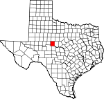
Runnels County, Texas Basics:
Runnels County Texas - Government Site
Population: 10,425
Area: 1051 square miles
County seat: Ballinger
Area code(s) in use: 325
Time zone: CST
High school graduate or higher: 79.1%
Bachelor's degree or higher: 15.6%
Median household income: $39,115
Persons in poverty: 20.9%
Home ownership rate: 71.4%
Mean travel time to work: 17.2 minutes
Adjacent counties:
Coke Coleman Concho Nolan Taylor Tom Green
Places in Runnels County, Texas
Bruce Field Airport,
Knot 2 Shabby Airport,
Winters Municipal Airport Ballinger Carnegie Library,
Ballinger Fire Department, Carnegie Library of Ballinger,
Edwin and Hattie Day House,
J Thiele Building,
Rowena Volunteer Fire Department,
Runnels County Jail,
Van Pelt House,
Wingate Volunteer Fire Department, Winters Public Library,
Z I Hale Museum Castleberry Cemetery,
Counts Cemetery,
Crews Cemetery,
Evergreen Cemetery,
Evergreen Cemetery,
Fairview Cemetery,
Hoffman Cemetery,
Lakeview Cemetery,
Maverick Cemetery,
Miles Cemetery,
Mount Victory Cemetery,
Northview Cemetery,
Norton Cemetery,
Norwood Cemetery,
Old Runnels Cemetery,
Protestant Cemetery,
Pumphrey Cemetery,
Saint Boniface Cemetery,
Saint Josephs Cemetery,
Wilmeth Cemetery Brady Coleman Runnels Baptist Area Church,
Brookshier Church,
Catholic Church Hall,
Church of Christ,
Church of Christ,
Church of the Nazarene,
First Baptist Church,
First Church of God,
Harmony Church,
Hopewell Church,
Lutheran Church,
Old Norton Church,
Saint Boniface Church,
Valley View Church Buffalo Bluff,
Deadmans Bluff,
Herrings Bluff,
Wilson Bluff Allen Lake Dam,
Baca Lake Dam,
Billups Lake Dam,
Country Club Lake Dam,
Currie Lake Dam,
Elm Creek Lake Dam,
Kuhn Lake Dam,
Lake Ballinger Dam,
Lake Winters Dam,
Lee Lake Dam,
Lloyd Lake Dam,
Mitchell Dam,
Moore Lake Dam,
Northington Lake Dam,
Odom Currie Wylie Estate Lake Number 1 Dam,
Odom Currie Wylie Estate Lake Number 2 Dam,
Old Lake Winters Dam,
Soil Conservation Service Site 1 Dam,
Soil Conservation Service Site 18 Dam,
Soil Conservation Service Site 19 Dam,
Soil Conservation Service Site 20 Dam,
Texas No Name Number 13 Dam Blue Gap,
Table Gap Ballinger Memorial Hospital,
North Runnels Hospital Country Club Lake Allen Number One Windmill,
Blue Gap (historical),
Crews,
Herring Ranch,
Kristoff School,
Marie,
Tokeen,
Winters Country Club Clayton Oil Field,
Cree Sykes Oil Field,
Fort Chadbourne Oil Field,
Hull-Dobbs Oil Field,
Motley Oil Field,
Rowena Oil Field Bearcat Stadium Ballinger,
Benoit,
Bethel,
Blanton, Blue Gap (historical), Brookshier, Content (historical),
Crews,
Drasco,
Hatchel,
Marie,
Maverick,
Miles,
Norton,
Olfen,
Pumphrey,
Rowena, Runnels (historical),
Valley View,
Wilmeth,
Wingate,
Winters Miles Post Office,
Norton Post Office,
Rowena Post Office,
Wingate Post Office,
Winters Post Office Allen Lake,
Baca Lake,
Ballinger City Lake,
Billups Lake,
Country Club Lake,
Currie Lake,
Elm Creek Lake,
Kuhn Lake,
Lake Old Winters,
Lake Winters,
Lee Lake,
Lloyd Lake,
Mitchell Lake,
Moore Lake,
Northington Lake,
Odom Currie Wylie Estate Lake Number 1,
Odom Currie Wylie Estate Lake Number 2,
Old Lake Winters,
Soil Conservation Service Site 1 Reservoir,
Soil Conservation Service Site 18 Reservoir,
Soil Conservation Service Site 19 Reservoir,
Soil Conservation Service Site 20 Reservoir,
Texas Noname Number 13 Ballinger Elementary School, Ballinger High School, Ballinger Junior High School,
Carver School,
Crossroads School,
Fairview Behavior Adjustment Center, Grape Creek Special Programs School, Miles Elementary School, Miles High School, Olfen Elementary School,
Trinity Early Childhood Center,
Winters Elementary School,
Winters Junior and Senior High School Antelope Creek,
Antelope Creek,
Bears Foot Creek,
Big Coyote Creek,
Bluff Creek,
Buck Creek,
Bulger Creek,
Butternut Creek,
Cow Branch,
Coyote Creek,
Eagle Branch,
Elm Creek,
Fish Creek,
Flag Branch,
Gap Creek,
Hog Creek,
Hog Creek,
Indian Creek,
Little Coyote Creek,
Live Oak Creek,
Long Branch,
Long Branch,
Mesquite Creek,
Middle Mustang Creek,
Mill Creek,
Mud Creek,
Mustang Branch,
Mustang Creek,
Oak Creek,
Pony Creek,
Quarry Creek,
Rattlesnake Creek,
Red Bank Creek,
Rocky Branch,
Rocky Creek,
Sand Branch,
South Fork Mud Creek,
Spring Branch,
Spur Creek,
Stag Branch,
Turkey Creek,
Valley Creek,
Wagon Tire Creek,
West Fork Turkey Creek,
Wire Hollow Creek Bald Knob,
Moro Mountain,
Table Mountain KRUN-AM (Ballinger),
KRUN-FM (Ballinger) Bowen Draw,
Bull Hollow,
Dry Hollow,
Dry Hollow,
Los Arroyos,
Spring Hollow,

