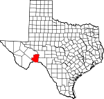
Terrell County, Texas Basics:
Terrell County Texas - Government Site
Population: 924
Area: 2358 square miles
County seat: Sanderson
Area code(s) in use: 432
Time zone: CST
High school graduate or higher: 75.5%
Bachelor's degree or higher: 16.2%
Median household income: $37,750
Persons in poverty: 16.2%
Home ownership rate: 71.1%
Mean travel time to work: 23.5 minutes
Adjacent counties:
Brewster Crockett Pecos Val Verde
Places in Terrell County, Texas
Big Canyon Ranch Airport,
Mitchell Nr One Airport,
Tate Ranch Airport,
Terrell County Airport Middle Watering Terrell County Emergency Medical Service, Terrell County Memorial Museum, Terrell County Public Library,
Terrell County Volunteer Fire Department Cedar Grove Cemetery,
Santa Rita Cemetery Sanderson Census Designated Place Roden Lake Dam,
Soil Conservation Service Site 10 Dam,
Soil Conservation Service Site 7 Dam,
Soil Conservation Service Site 8 Dam,
Soil Conservation Service Site 9 Dam Standifer Gap Abilene Christian College Ranch,
Agua Verde Crossing,
Allen Ranch,
Allison Ranch,
Banner Canyon Windmill,
Barksdale Ranch,
Bell Ranch,
Big Canyon Ranch,
Big Lozier Ranch,
Brickner Ranch,
Brown Ranch,
Carruthers Ranch,
Cedar Station,
Cinco de Mayo Crossing,
Cinco de Mayo Ranch,
Circle Dot Ranch,
Continental Ranch,
Corder Ranch,
Cripple Goose Windmill,
Dead Man Windmill,
Deaton Ranch,
Downie Ranch,
Downie Ranch,
Dry Creek Ranch,
Dudley Ranch,
East Martin Windmill,
El Indio Crossing,
El Mesquite Crossing,
El Moro Crossing,
Farm Tank Windmill,
Foster Ranch,
Gatlin Ranch,
Goldwire Ranch,
Goodwin Ranch,
Hagelstein Ranch,
Hardgrave Ranch,
Harkey Windmill,
Harkey-Banner Windmill,
Harkins Ranch,
Harrell Ranch,
Herra Dura Crossing,
Hutcherson Ranch,
James Ranch,
Johnson Ranch,
Kerr Ranch,
Lozier Crossing,
Mare Canyon Crossing,
McClain Ranch,
Miller Ranch,
Mitchell Ranch,
Mitchell Ranch,
Mitchell Ranch,
Monroe Ranch,
Murrah Ranch,
Oasis Ranch,
Odom Ranch,
Paso Colorado Crossing,
Paso Verde Crossing,
Riggs Ranch,
Rock House Ranch,
Rock Pens Ranch,
Rose Ranch,
Sanderson Canyon Crossing,
Santa Rosa Crossing,
Seventeen Ranch,
Taylor Ranch,
Terrell Station,
Turner Ranch,
Walker Ranch,
Watts Ranch,
Whitehead Ranch,
Williams Ranch,
Wood Ranch,
Word Ranch Fort Meyer (historical) Brown Bassett Gas Field Casa de Peidras, Cocklebur (historical),
Dryden,
Dryden Crossing,
Emerson, Fedora (historical), Free (historical),
Lozier,
Malvado,
Mofeta,
Moser,
Sanderson,
Shaw,
Watkins (historical) Dryden Post Office,
Sanderson Post Office Roden Lake,
Soil Conservation Service Site 10 Reservoir,
Soil Conservation Service Site 7 Reservoir,
Soil Conservation Service Site 8 Reservoir,
Soil Conservation Service Site 9 Reservoir Sanderson Elementary School, Sanderson High School, Sanderson Junior High School
Black Water Hole,
Blue Water Hole Spring, Blue Water Hole Springs,
Buena Springs, Cedar Springs,
Cedars Springs, Chandler Springs, Craig Springs, Dripping Springs,
Geddis Springs, Indian Springs,
Indian Wells Spring,
Johnson Seep, Julius Springs,
King Springs, Lozier Springs,
Luis Guerra Springs (historical),
Meyers Spring,
Meyers Springs, Outlaw Springs, Packingham Springs, Panther Springs,
Richland Spring, Richland Springs, Seminole Springs, Sulphur Springs,
Sweetwater Springs,
T-5 Springs, Vanderbeek Springs,
Wolf Spring Antonio Creek,
Balcon Creek,
Buck Creek,
Buena Creek,
Candilla Creek,
Cedar Creek,
Cook Creek,
Cow Creek,
Dry Creek,
Garcia Creek,
Independence Creek,
Indian Creek,
Magoy Creek,
McKay Creek,
North Fork Independence Creek,
Persimmon Creek,
Pony Creek,
Prairie Creek,
San Francisco Creek,
Sanderson Creek Cable Hills,
Loma Vista,
Shafter Hills,
Two Top Mountain Bear Canyon,
Bearfoot Canyon,
Big Canyon,
Britton Canyon,
Candilla Canyon,
Cedar Draw,
Coyote Canyon,
Dead Man Canyon,
Deer Canyon,
Downie Draw,
Eightmile Draw,
Geddis Canyon,
Hagler Canyon,
Harkey Draw,
Horsehead Canyon,
Isinglass Canyon,
Jabalina Canyon,
Javelina Canyon,
Lozier Canyon,
McClain Canyon,
Mesquite Canyon,
Meyers Canyon,
Mile and One Half Canyon,
Mitchell Draw,
North Canyon,
Oil Well Canyon,
Outlaw Canyon,
Palma Canyon,
Prairie Canyon,
Pumpville Canyon,
Putman Canyon,
Reagan Canyon,
Red Windmill Draw,
Richland Canyon,
Sanderson Canyon,
Seminole Canyon,
Sevenmile Canyon,
Seventeen Draw,
Shafter Canyon,
South Geddis Canyon,
Surveyor Canyon,
Taylor Canyon,
Threemile Draw,
Thurston Canyon,
Washboard Canyon,
Whitely Canyon,

