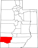
Iron County, Utah Basics:


Iron County Utah - Government Site

Population: 46,773
Area: 3297 square miles
County seat: Parowan
Area code(s) in use: 435
Time zone: MST
High school graduate or higher: 91.2%
Bachelor's degree or higher: 26.6%
Median household income: $42,296
Persons in poverty: 19.4%
Home ownership rate: 62.5%
Mean travel time to work: 18.2 minutes


Adjacent counties:
Beaver  Garfield  Kane  Lincoln (NV)  Washington  
Find in Utah

Map of the Iron County area


Our detail map of Iron County shows the Iron County, Utah boundary lines and other interesting items.

Places in Iron County, Utah

  Airports     show all on map

Beryl Junction Airport, Cedar City Heliport, Cedar City Regional Airport, Citabriair Airport, Clark Airport, Flying Cal Ute Rancheros Airport, Parowan Airport, Sun Valley Estates Airport

  Arches     show all on map

Flanigan Arch, Square Arch

  Areas     show all on map

Cedar Breaks Amphitheater

  Basins     show all on map

Blowout Pit, Blue Spring Valley, Cougar Basin, Dry Valley, Elliker Basin, Grass Valley, Horse Valley, Little Valley, Little Valley, Little Valleys, Lower Bear Valley, Oak Basin, Parowan Valley, Sidney Valley, The Iron Bowl, The Movies, The Saucer, Upper Bear Valley

  Benches     show all on map

Goat Ledges, Horse Bench, Kolob Terrace, Mud Spring Bench, Slough Bench, The Neck

  Buildings     show all on map

Beryl Fire Department, Brian Head Fire Department, Brian Head Police Department, Cedar City Fire Department Station 1, Cedar City Fire Department Station 2, Cedar City Police Department, Enoch City Police Department, Hamblin Valley Fire and Rescue, Iron County Ambulance, Iron County Sheriff's Office, Kanarraville Fire Department, Newcastle Fire Department, Paragonah Volunteer Fire Department, Parowan Fire Department, Parowan Police Department, Southern Utah University Office of Public Safety, Utah Highway Patrol Section 11 Cedar City Office

  Canals     show all on map

Escalante Mine Canal, Spring Creek Ditch

  Capes     show all on map

Bauer Point, Corry Point, Jackson Point, O'Neil Point, Point Supreme, Sherratt Point, Spectra Point, Tucker Point, Upper Point

  Cemeteries     show all on map

Cedar City Cemetery, Enoch Cemetery, Kanarraville Cemetery, Modena Cemetery, Newcastle Cemetery, Paragonah Cemetery, Parowan City Cemetery, Pinto Cemetery, State Line Cemetery, Summit City Cemetery

  Census     show all on map

Beryl Junction Census Designated Place, Modena Census Designated Place, Newcastle Census Designated Place, Summit Census Designated Place

  Churches     show all on map

Assembly of Jesus Christ, Beryl Baptist Church, Bethel Ministry, Christ the King Catholic Church, Church of Christ, Community Presbyterian Church, First Baptist Church, Jehovahs Witnesses Cedar City Congregation, Saint Judes Episcopal Church, The Church of Jesus Christ of Latter Day Saints, The Church of Jesus Christ of Latter Day Saints, The Church of Jesus Christ of Latter Day Saints, The Church of Jesus Christ of Latter Day Saints, The Church of Jesus Christ of Latter Day Saints, The Church of Jesus Christ of Latter Day Saints, The Church of Jesus Christ of Latter Day Saints, The Church of Jesus Christ of Latter Day Saints, The Church of Jesus Christ of Latter Day Saints, The Church of Jesus Christ of Latter Day Saints, The Church of Jesus Christ of Latter Day Saints, The Church of Jesus Christ of Latter Day Saints, The Church of Jesus Christ of Latter Day Saints, The Church of Jesus Christ of Latter Day Saints, The Church of Jesus Christ of Latter Day Saints, The Church of Jesus Christ of Latter Day Saints, The Church of Jesus Christ of Latter Day Saints, The Church of Jesus Christ of Latter Day Saints, Trinity Lutheran Church, Valley Bible Church, Zion Baptist Temple

  Cliffs     show all on map

Graff Point, Lee Point, Muley Point, Pinon Point, Strawberry Point, The Highleap, Wasatch Rampart, White Cliff

  Craters     show all on map

The Craters

  Dams     show all on map

Cedar City Corp Storage Dam, Foster Dam, Greens Lake Debris Basin Number Three Dam, Greens Lake Debris Basin Number Two Dam, Greens Lake Retarding Dam Number Four, Harris Gubler Dam, Meadow Hollow Dam, Meadow Lodge Lake Dam, Modena Dam, Modena Draw Dam, Newcastle Dam, Red Creek Dam, Stewart Lamb Dam, Yankee Meadows Dam

  Flats     show all on map

Bear Flat, Blue Meadows, Bowers Flat, Buckhorn Flat, Butcher Meadow, Chimney Meadow, Co-op Flat, East Horse Flat, Horse Pasture, John L Flat, Long Flat, Long Flat, Lund Flats, Martins Flat, Oak Spring Flat, Oak Springs Flat, Ponderosa Park, Reed Valley, Richie Flat, Round Meadow, Sagebrush Flat, Salt Licks, Sandy Fields, Stud Flat, The Bottoms, The Meadows, Third House Flat, Walts Flat, Webster Flat, Yankee Meadows

  Gaps     show all on map

Arrowhead Pass, Bob Leroy Pass, Cottonwood Canyon Narrows, Devils Gap, Eightmile Pass, Herd Pass, Little Gap, Parowan Gap, Summit Narrows, The Narrows, The Narrows, Winn Gap

  Hospitals     show all on map

Valley View Medical Center

  Lakes     show all on map

Alpine Pond, Aspen Lake, Bumblebee Lake, Burnt Spot Pond, CCC Pond, Cedar Pond, Chalk Hollow Pond, Coyote Pond, Dead Lake, Deer Lake, District Pond, Dry Lake, Dry Lakes, First Lake, Green Lake, Hendrickson Lake, Hoosier Lake, Horseshoe Pond, Hot Springs Canyon Pond, Little Salt Lake, Marshall Pond, Mud Lake, Penney Hollow Pond, Quichapa Lake, Rush Lake, Ryan Ponds, Tebbs Pond, The Forebay, Toms Lake

  Locales     show all on map

Adams Ranch, Bear Valley Guard Station, Boy Scouts of America Camp, Brian Head Ski Area, Butcher Spring Trough, Casting of Lots Site, CCC Camp, Cedar Breaks Lodge, Cedar Breaks Visitor Center, Cedar Canyon Campground, Cedar Canyon Ski Area, Cedar City KOA, Chaney Ranch, Chessmen Overlook, Clark Farm, Clark Ranch, Deer Haven Campground, Gold Springs, Grants Ranch, Iron Mountain Wye, Jessie Tie Exclosure, Johnston Ranch, Kelsey Deer Camp, Leigh Farm, Lone Tree, Louder Ranger Station, Lower Cottonwood Troughs, Page Ranch, Parowan Gap Petroglyphs, Pinto, Pipeline Spring Trough, Point Supreme Campground, South Main Square, Stevensville, Sunset View, The Plaza, Thunder Ridge Campground, Tinks Racetrack, Upper Cottonwood Troughs, Upper Grants Ranch, Uvada, Vermillion Castle Campground, Vermillion Castle Guard Station, Wood Ranch, Woolsey Ranch, Zion Canyon View, Zion Overlook

  Mines     show all on map

Armstrong Mine, Cluff Mine, Colorado Mine (historical), Columbia Steel Mine, East Pioche Mine, Escalante Mine, Etna Mine, Great Western Mine, Homestake Mine, Independence Mine, Jennie Mine, Johnny Mine, Jumbo Mine, Lindsay Hill Mine, MacFarlane Mine, New Arrowhead Mine, Ofer Mine, Skougard Mine, Smith Mine, The Quarry, Tucker Coal Mine, Vermillion Mine, West Pioche Mine

  Parks     show all on map

Cedar Breaks National Monument, Cedar City Upland State Game Sanctuary, Deep Creek Wildlife Management Area, Escalante Interpretive Site, Iron Mission State Park, Jefferson Hunt Monument, Parowan Front Wildlife Management Area

  Pillars     show all on map

Grand Castle, Vermillion Castle

  Plains     show all on map

Escalante Desert, Lava Desert, Markagunt Plateau, Neck of the Desert, Red Desert

  Populated Places     show all on map

Avon, Beryl, Beryl Junction, Brian Head, Cedar City, Desert Mound, Enoch, Fort Johnson, Halivah, Hamiltons Fort, Hamlin Valley, Heist, Iron Mountain, Iron Springs, Kanarraville, Latimer, Lund, Modena, Newcastle, North View, Old Irontown, Paragonah, Parowan, State Line, Summit, Wheatgrass, Yale Crossing, Zane

  Post Offices     show all on map

Cedar City Post Office, Parowan Post Office

  Ranges     show all on map

Antelope Range, Black Mountains, Harmony Mountains, Needle Mountains, North Hills, Paradise Mountains, Red Hills

  Reserves     show all on map

Ashdoen Gorge Wilderness, Ashdown Gorge Wilderness, Paiute Indian Reservation

  Reservoirs     show all on map

Cedar City Corp Storage Reservoir, Crestline Reservoir, Forces Reservoir, Foster Reservoir, Greens Lake Debris Basin Number Three, Greens Lake Debris Basin Number Two, Greens Lake Retarding Basin Number Four, Harris Gubler Reservoir, Lamb Reservoir, Meadow Hollow Reservoir, Meadow Lodge Lake, Modena City Reservoir, Modena Draw Reservoir, Modena Reservoir, Monument Knolls Reservoir, Newcastle Reservoir, North Spring Reservoir, Paradise Reservoir, Red Creek Reservoir, Red Creek Reservoir, Robinson Reservoir, Rose Valley Reservoir, Yankee Meadows Reservoir

  Ridges     show all on map

Adams Barrier, Braffit Ridge, Bristlecone Ridge, Broken Ridge, Chessmen Ridge, Columbine Ridge, Everstein Ridge, Jericho Ridge, Middle Ridge, Navajo Ridge, Orange Ridge, Panaca Ridge, Shooting Star Ridge, Snow Ridge, Windy Ridge

  Schools     show all on map

Cedar City High School, Cedar City Middle School, Cedar East School, Cedar North School, Cedar South School, College of Southern Utah, Enoch School, Escalante Valley School, Fiddlers Canyon School, Parowan High School, Parowan School

  Slopes     show all on map

Shimhi

  Springs     show all on map

Anderson Spring, Antelope Springs, Arrowhead Spring, Aspen Spring, Aspen Spring, Baboon Seep, Bannion Spring, Bell Spring, Bible Spring, Big Basket Spring, Big Hollow Spring, Big Maple Spring, Big Spring, Big Spring, Big Swamp Springs, Birch Spring, Bluebell Spring, Bob Leroy Spring, Bone Hollow Spring, Brush Patch Seep, Brush Spring, Buckhorn Spring, Bull Spring, Bull Spring, Bumblebee Spring, Burnt Spring, Butcher Spring, Butcher Spring, Cattle Spring, Cheney Spring, Chipman Seep, Chokecherry Spring, Clarks Spring, Co-op Spring, Cold Spring, Cooks Spring, Cool Spring, Cottonwood Spring, Cottonwood Spring, Cottonwood Spring, Cottonwood Springs, Cove Spring, Cox Springs, Crystal Spring, Crystal Springs, Culver Spring, Day Spring, Decker Spring, Deer Spring, Desert Spring, Dipping Vat Spring, Dry Camp Valley Spring, Dry Willow Spring, Duncan Spring, Eagle Spring, Edward Spring, Eightmile Spring, Eightmile Springs, First Spring, Fivemile Spring, Flint Spring, Fourmile Spring, Fox Hollow Spring, Fremont Spring, Grouse Spring, Guyman Seep, Hidden Spring, Hidden Spring, Holly Oak Spring, Iron Peak Spring, Jack Henry Seep, Jackrabbit Spring, Jensen Spring, Joel Spring, Jones Spring, Kane Spring, Keel Spring, Lime Spring, Lister Spring, Lister Spring, Little Basket Springs, Little Maple Spring, Little Pinto Spring, Lockeridge Spring, Lone Pine Spring, Lost Spring, Lower Trough Spring, Lower Water Spring, Lundale Spring, Lundell Spring, Mahogany Seep, Maple Spring, Maple Spring, Marsden Spring, Meadow Spring, Middle Spring, Mineral Spring, Mormon Gulch Spring, Mountain Spring, Mud Spring, Mud Spring, Mud Spring, Mud Spring, Mud Springs, Mud Springs, Mustang Spring, Navajo Spring, Nephi Spring, Newels Spring, North Kane Spring, North Spring, North Trough Spring, Oak Spring, Oak Spring, Oak Springs, Pace Spring, Paradise Spring, Paramore Spring, Paridise Spring, Peaks Spring, Pine Spring, Pinto Spring, Pipeline Spring, Prout Spring, Robb Spring, Roberts Spring, Rock Quarry Spring, Rock Spring, Rock Spring, Rock Spring, Rock Spring, Rosebud Spring, Rosenberg Spring, Ryan Spring, Sand Cliff Spring, Sand Spring, Sawmill Spring, Sawmill Spring, Second Spring, Serviceberry Spring, Simpkins Spring, Sixmile Spring, Slide Spring, Sols Spring, South Fork Spring, South Spring, Spanish George Spring, Spring Branch Spring, Sulphur Spring, Summer Camp Spring, Sweetwater Spring, The Seeps, Third Spring, Three Creeks Spring, Trap Spring, Trough Spring, Typhoid Spring, Upper Trough Spring, Warm Spring, Warm Springs, Watercress Spring, West Spring, White Canyon Spring, Wide Hollow Spring, Wildcat Spring, Willow Spring, Willow Spring, Willow Spring, Wire Grass Spring

  Streams     show all on map

Arch Creek, Ashdown Creek, Benson Creek, Blue Spring Creek, Bowery Creek, Braffits Creek, Brown Creek, Caddy Creek, Camp Creek, Castle Creek, Center Creek, Center Creek, Chokecherry Creek, Chokecherry Creek, Clear Creek, Coal Creek, Coyote Creek, Crow Creek, Crystal Creek, Deer Creek, Deer Creek, Dry Lakes Creek, Duncan Creek, East Fork Braffits Creek, Gold Springs Wash, Groves Creek, Hicks Creek, Hoosier Creek, Iron Springs Creek, Johnson Creek, Lake Creek, Le Fevre Creek, Left Fork Bunker Creek, Left Fork Sandy Creek, Little Creek, Little Pinto Creek, Locust Creek, Long Valley Creek, Lowder Creek, Maple Canyon Creek, Middle Fork Sandy Creek, Middle Fork Threemile Creek, Mill Creek, Murie Creek, North Fork Threemile Creek, Parowan Creek, Pickering Creek, Pine Creek, Pinto Creek, Quichapa Creek, Rattle Creek, Rattlesnake Creek, Red Creek, Red Creek, Reeves Creek, Right Fork Bunker Creek, Right Hand Creek, Sandy Creek, Shirts Creek, Shiver Creek, Shoal Creek, Shooting Star Creek, Skoots Creek, South Fork Red Creek, South Fork Threemile Creek, Spring Creek, Spring Creek, Squaw Creek, Summit Creek, Three Creeks, Tillie Creek, Tommy Creek, Trail Creek, Urie Creek, West Fork Braffits Creek, West Fork Summit Creek, Willow Creek, Willow Creek

  Summits     show all on map

Anderson Mountain, Antelope Peak, Avavick Knoll, Baboon Peak, Badger Peak, Bauers Knoll, Bean Hill, Big Hill, Black Knoll, Black Mountain, Black Point, Black Reef, Blowhard Mountain, Blue Knoll, Blue Spring Mountain, Bob Leroy Peaks, Brian Head, Brown Knoll, Broze Knoll, Burnt Peak, Cedar Breaks, Cedar Mountain, Cedar Mountain, Cedar Peak, Chipman Peak, Cinder Hill, Co-op Knoll, Cottonwood Mountain, Cross Hollow Hills, Dairy Hill, Desert Mound, Dry Willow Peak, Duncan Mountain, Eagle Peak, Eightmile Hills, Elephant Rock, First Mound, Flat Top Mountain, Gooseberry Point, Government Peak, Granite Mountain, Gray Knoll, Grouse Peak, Hancock Peak, Haystack Mountain, Henderson Hill, High Mountain, Hole in the Rock, Horse Valley Peak, Hot Springs Peaks, Houston Mountain, Iron Mountain, Iron Peak, Jack Henry Knoll, Jackrabbit Mountain, Jones Hill, Kanarra Mountain, Little Creek Peak, Lone Tree Mountain, Long Hill, Lookout Knoll, Mammoth Summit, Meadow Hill, Miller Knoll, Miner Hill, Miners Peak, Monument Peak, Mound Mountain, Mount Claron, Mount Elenore, Mount Escalante, Mountain Spring Peak, Mud Spring Hills, Mule Peak, Navajo Point, Noahs Ark, North Hills, North Peaks, Old Rambler Hill, P Hill, Page Point, Paradise, Pine Spring Knoll, Prince Mountain, Pryor Knoll, Red Hill, Red Hills, Red Hills, Red Peak, Rice Mountain, Sandy Peak, Second Mound, Showalter Mountain, Sidney Peaks, Silver Peak, Spirit Peak, Square Mountain, Steamboat, Steamboat Mountain, Stoddard Mountain, Sugarloaf Mountain, Sugarloaf Mountain, Summit Mountain, Swayback Knoll, Swett Hills, Swett Peak, Table Butte, The Bald Hills, The Bartizan, The Knoll, The Point, The Pyramids, The Red Hill, The Three Peaks, Three Knolls, Three Knolls Summit, Three Peaks, Twin Peaks, Twin Peaks, Valentine Peak, Websters Knolls, White Hill, White Mountain, White Rocks, Wood Knoll

  Towers     show all on map

KBRE-AM (Cedar City), KBRE-FM (Cedar City), KGSU-FM (Cedar City), KGSU-FM (Cedar City), KSUB-AM (Cedar City), KSUB-FM (Cedar City)

  Trails     show all on map

Alpine Pond Trail, Big Hollow Trail, Dry Lakes Trail, Duncan Canyon Trail, Rattlesnake Creek Trail, Rattlesnake Trail, Spruce Trail

  Valleys     show all on map

Adams Canyon, Adams Hollow, Alum Cove, Arch Canyon, Ashton Canyon, Ashton Draw, Big Hollow Wash, Billy West Canyon, Black Canyon, Blawn Wash, Blowhard Hollow, Blowout Hollow, Blue Valley, Bone Hollow, Bristlecone Canyon, Broad Hollow, Browns Canyon, Buckskin Valley, Buckskin Wash, Bull Spring Wash, Bull Valley, Bullion Canyon, Cabbage Valley, Calf Hollow, Castle Valley, Cedar Canyon, Cedar Valley, Chalk Hollow, Cheney Spring Canyon, Chessmen Canyon, Chloride Canyon, Clarks Canyon, Coal Canyon, Columbine Canyon, Corral Hollow, Cottonwood Canyon, Cottonwood Canyon, Cottonwood Canyon, Cottonwood Wash, Cresant Hollow, Crestline Draw, Crook Canyon, Cross Hollow, Culbert Canyon, Dalley Canyon, Dan Leigh Hollow, Dark Hollow, Death Hollow, Deep Canyon, Deer Hollow, Deer Lodge Canyon, Den Hollow, Dennis Hollow, Dick Palmer Wash, Doubleup Hollow, Dry Canyon, Duncan Canyon, Elderberry Canyon, Ellies Canyon, Escalante Valley, Everstein Hollow, Fiddlers Canyon, First Canyon, First Left Hand Canyon, Fish Hollow, Fishers Wash, Forks Valley, Fourmile Wash, Fox Hollow, Free Thought Canyon, Fremont Canyon, Fremont Wash, Green Hollow, Hells Canyon, Highleap Canyon, Hogans Wash, Hole in the Wall, Horse Canyon, Horse Hollow, Horse Hollow, Horse Hollow, Horse Valley, Hot Springs Canyon, Houchen Hollow, Hurricane Fault, Hyatt Canyon, Indian Draw, Indian Hollow, Jackrabbit Wash, Jackson Wash, Jako Wash, Jericho Canyon, Jessie Tie Wash, Joel Spring Canyon, Johnny Canyon, Kane Spring Wash, Kings Valley, Labyrinth Canyon, Lake Hollow, Last Chance Canyon, Lavender Canyon, Leach Canyon, Lees Spring Wash, Left Quichapa Canyon, Little Horse Valley, Little Horse Valley, Little Valley Hollow, Long Hollow, Long Hollow, Lost Spring Hollow, Maple Canyon, Maple Spring Hollow, Marys Hollow, McDonald Wash, Meadow Hollow, Middle Canyon, Middle Spring Wash, Midway Valley, Mineral Canyon, Modena Draw, Moots Hollow, Mormon Gulch, Mortensen Canyon, Moseman Canyon, Mountain Spring Wash, Mud Spring Canyon, Mud Spring Wash, Negro Liza Wash, Nelson Canyon, Nephi Draw, North Fork Chloride Canyon, North Swale, Oak Basin Draw, Ofer Basin, Open Ridge Draw, Order Canyon, Owens Hollow, Pace Canyon, Paradise Canyon, Parowan Canyon, Parowan Canyon, Peak Canyon, Penney Hollow, Pine Hollow, Pinon Park Wash, Pole Canyon, Pole Canyon, Poorman Ranch Canyon, Potato Hollow, Prout Wash, Red Canyon, Red Valley, Rice Canyon, Right Quichapa Canyon, Rock Canyon, Rock Canyon, Rock Hole Wash, Rustlers Draw, Sackett Hollow, Sage Valley, Salt Creek Canyon, Sand Spring Canyon, Sawmill Canyon, Sawmill Canyon, Second Canyon, Second Left Hand Canyon, Sevy Hollow, Shakespeare Hollow, Shirts Canyon, Silver Canyon, Slide Hollow, Slip Canyon, Slough Wash, South Fork Chloride Canyon, Spanish Hollow, Spirit Canyon, Spring Branch Canyon, Squaw Hollow, Steer Hollow, Stephens Canyon, Stoddard Canyon, Strawberry Canyon, Stringies Canyon, Studhorse Draw, Sweetwater Gulch, Tebbs Hollow, Teddys Valley, Telegraph Draw, The Dry Wash, Third Canyon, Tippets Valley, Trail Draw, Tri Story Canyon, Twin Peaks Canyon, Urie Hollow, Water Canyon, Water System Canyon, Wayne Canyon, Webb Canyon, West Swale, Whiskey Hollow, White Canyon, White Rocks Wash, Whitney Canyon, Wide Hollow, Wide Hollow, Wide Hollow, Wilson Canyon, Winn Hollow, Wood Canyon, Woods Hollow

  Wells     show all on map

Auston Well, Blue Knoll Well, Bridle Well, C C C Well, Goodman Well, Leigh Well, Lowe Well, Lyman Well, Marshall Well, Norte Well, Stubbs Well, Stubbs Well, Websters Well

  Woods     show all on map

The Cottonwoods,

Iron County, Utah Population By Race (2012 estimate)

RacePopulation
WhiteIron County White population 43,87343,873  
American IndianIron County American Indian population 1,1231,122
MixedIron County Mixed population 842841
AsianIron County Asian population 515514
BlackIron County Black population 281280
Hawaiian & Pacific IslanderIron County Hawaiian & Pacific Islander population 187187

Additional population tables :
State population table
Utah population by county