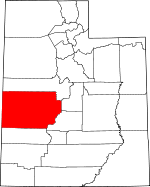
Millard County, Utah Basics:


Millard County Utah - Government Site

Population: 12,570
Area: 6572 square miles
County seat: Fillmore
Area code(s) in use: 435
Time zone: MST
High school graduate or higher: 87.0%
Bachelor's degree or higher: 19.0%
Median household income: $47,235
Persons in poverty: 12.9%
Home ownership rate: 75.0%
Mean travel time to work: 17.4 minutes


Adjacent counties:
Beaver  Juab  Lincoln (NV)  Sanpete  Sevier  White Pine (NV)  
Find in Utah

Map of the Millard County area


Our detail map of Millard County shows the Millard County, Utah boundary lines and other interesting items.

Places in Millard County, Utah

  Airports     show all on map

Delta Community Medical Center Heliport, Delta Municipal Airport, Desert Aviation Airport, Fillmore Community Medical Center Heliport, Fillmore Municipal Airport, Garrison Airport, Intermountain Power Heliport

  Areas     show all on map

Badlands, Bishop Springs Area, Deer Pasture, Painted Potholes, Partridge Mountain Research Natural Area, Pauls Meadow, Topaz Slough Conservation Area

  Arroyos     show all on map

Browns Wash, Cedar Pass Wash, Deadman Wash, Jensen Wash, North Juniper Wash, Red Wash, Sand Wash, South Juniper Wash, Steamboat Wash

  Basins     show all on map

Browns Hole, Bull Valley, Cal Valley, Devils Kitchen, Dog Valley, Grassy Cove, Hell'n Moriah Kitchen, Hellhole, Hole in the Ground, Horse Heaven, King Cove, Little Horse Heaven, Little Valley, Oak Creek Sinks, Red Valley, Robins Valley, Sawmill Basin, Scipio Valley, Swasey Bottom, The Barn, The Devils Armchair, The Sink, White Sage Valley, Wills Hole

  Benches     show all on map

Rattlesnake Bench, Red Ledges, Trail Spring Bench

  Bends     show all on map

Beaver Bottoms, Gunnison Bend, The Elbow, The Elbow

  Buildings     show all on map

Delta Fire Department, Eskdale Fire Department, Fillmore Fire Department, Garrison Fire Department, Hinckley Fire Department, Holden Fire Department, Kanosh Volunteer Fire Department, Leamington Volunteer Fire Department, Lynndyl Fire Department, Meadow Fire Department, Millard County Ambulance Service Delta Station, Millard County Ambulance Service Fillmore Station, Millard County Sheriffs Office Delta Substation, Oak City Fire Department, Oak Creek Ranger Station, Scipio Ambulance Service, Scipio Fire Department, Territorial Statehouse, Utah Highway Patrol Section 14 Fillmore Office

  Canals     show all on map

Abraham Canal, Almond Ditch, Blake Ditch, Bliss Canal, Canal A, Canal B, Canal C, Center Ditch, Central Utah Canal, Church Spring Ditch, Current Spring Ditch, Dameron Ditch, Deseret Canal, East Fork Ditch, Eliason Jensen Ditch, Fullmer Canal, Gronning Canal, Henrie Ditch, Highline Canal, Johnson Ditch, Jones Ditch, Langston Ditch, Leamington Canal, Lee Ditch, Little Abraham Canal, Lowline Canal, Lyman Ditch, Macks Ditch, Marshall Ditch, Melville East Canal, Melville West Canal, Neeley Ditch, Nielson Ditch, North Ditch, Oasis Canal, Old Canal, Pete Black Cut, Pioneer Ditch, Reid Canal, Sink Ditch, South Hinckley Canal, South Track Canal, Stewart Ditch, Styler Ditch, Terry Ditch, Tolbert Ditch, Town Ditch, Town Ditch, Walker Canal, Will Ruben Canal, Wilson Canal

  Capes     show all on map

Long Point of the Buckskins, Middle Point of the Buckskins, Needle Point, Telegraph Point

  Cemeteries     show all on map

Burbank Cemetery, Delta City Cemetery, Deseret City Cemetery, Fillmore Cemetery, Hinckley City Cemetery, Holden Cemetery, Kanosh Cemetery, Leamington Cemetery, Lynndyl Cemetery, Meadow Cemetery, Oak City Cemetery, Oasis Cemetery, Scipio Cemetery, Sutherland Cemetery

  Census     show all on map

Deseret Census Designated Place, Oasis Census Designated Place, Sutherland Census Designated Place

  Channels     show all on map

Old Channel

  Churches     show all on map

Delta Community Presbyterian Church, Grace Baptist Church, The Church of Jesus Christ of Latter Day Saints, The Church of Jesus Christ of Latter Day Saints, The Church of Jesus Christ of Latter Day Saints, The Church of Jesus Christ of Latter Day Saints, The Church of Jesus Christ of Latter Day Saints, The Church of Jesus Christ of Latter Day Saints, The Church of Jesus Christ of Latter Day Saints, The Church of Jesus Christ of Latter Day Saints, The Church of Jesus Christ of Latter Day Saints, The Church of Jesus Christ of Latter Day Saints, The Church of Jesus Christ of Latter Day Saints, The Church of Jesus Christ of Latter Day Saints, The Church of Jesus Christ of Latter Day Saints, The Church of Jesus Christ of Latter Day Saints, The Church of Jesus Christ of Latter Day Saints, The Church of Jesus Christ of Latter Day Saints, The Church of Jesus Christ of Latter Day Saints, Water of Life Lutheran Church

  Cliffs     show all on map

Black Point, Deadman Point, Devils Twist, Enoch Point, Fifteenmile Point, Lava Dam, Monument Point, Politician Point, Warm Point

  Craters     show all on map

Tabernacle Crater

  Dams     show all on map

D M A D Dam, Diversion Dam, Fool Creek Number One Dam, Fool Creek Number Two Dam, Gunnison Bend Dam, Mormon Gap Dam, Pruess Lake Dam, Scipio Lake Dam

  Flats     show all on map

Al Gay Flat, Blue Lake, Clay Flat, Clear Spot Flat, Fool Creek Flat, Indian Flat, Indian Ranch, Little Flat, Mud Lake, Pine Valley Hardpan, Taylors Flat, Trilobite Beds, Tule Valley Hardpan, Wah Wah Valley Hardpan, White Sage Flat, White Sage Flat

  Forests     show all on map

Desert Experimental Range

  Gaps     show all on map

Big Jensen Pass, Black Rock Pass, Burbank Pass, Cedar Pass, Cedar Pass, Cedar Pass, Coalbed Pass, Cove Fort Dog Valley Pass, Cowboy Pass, Cowboy Pass, Coyote Pass, Crystal Peak Pass, Cys Pass, Dome Canyon Pass, Georges Pass, Government Pass, Headlight Gap, Headlight Pass, High Rock Pass, Hole-in-the-Rock, Indian Pass, Iron Mine Pass, Johnson Pass, Juniper Pass, Little Drum Pass, Little Jensen Pass, Lone Cedar Pass, Lone Cedar Pass, Marjum Pass, Middle Pass, Mormon Gap, Mountain Home Pass, Okelberry Pass, Pine Pass, Red Pass, Red Pass, Red Pass, Sand Pass, Scipio Pass, Skull Rock Pass, Snake Pass, Sneakover Pass, Steamboat Pass, The Barn Pass, The Narrows, Toms Knoll Pass, Upper Pass, Wild Horse Pass, Willow Gap

  Hospitals     show all on map

Delta Community Medical Center, Fillmore Community Medical Center

  Lakes     show all on map

Alexander Lake, Bitterweed Lake, Burnt Tree Pond, Clear Lake, Cockleburr Lake, Crafts Lake, Deep Lake, Hodgsen Pond, Jackson Pond, Johnson Pond, Rain Lakes, Robins Lake, Ruths Pond, Salt Lake, Salt Marsh Lake, Scipio Lake, Sevier Lake, Swan Lake, Swan Lake Salt Marsh, The Lakes, Topaz Slough, Watsons Cow Pond

  Lava     show all on map

The Cinders

  Locales     show all on map

Adelaide Campground, Bagnall Corral, Balsam Picnic Area, Buckskin Charley Picnic Area, Burbank, CCC Camp Site, Copleys Cove Picnic Area, Cove Fort (historical), Cruz, Davies Ranch, Dearden Ranch, Desert Range Experimental Station Headquarters, Fool Creek, Gunnison Massacre Site, Herbert Ranch, Ibex Corral, Indian Springs Guard Station, IPP Power Plant, Little Creek Campground, Lyman Farm and Feedlot, Maple Grove Campground, Meadow Creek Campground, Oak Creek Campground, Old Cove Fort (historical), Pioneer Administrative Site, Pistol Rock Picnic Area, Platnation Flat Campground, Probst Corral, Range Headquarters, Robison Ranch, School Bus Corral, Shingle Mill Picnic Area, Smithville, Sunflower, The Gap, The Hermits Cabin, Tin Well, Topaz Camp, Wagons West RV Campground, Wheeler Amphitheater, Wild Horse Corral, Woodrow, Young Ranch

  Mines     show all on map

Brown Queen Mine, Cudahy Mine, Drum Mine, Jewkes Mine, Klondike Mine, Purple Sage Mine, Rock Corral Quarry

  Parks     show all on map

Bennett Field Wildlife Management Area, Black Cedar Hill Wildlife Management Area, Cemetery Wildlife Management Area, Circus Hollow Wildlife Management Area, Clear Lake Waterfowl Management Area, Corn Creek Wildlife Management Area, Fort Deseret State Park, Gunnison Massacre Historical Monument, Halfway Hill Wildlife Management Area, Holden Wildlife Management Area, Kanosh Wildlife Management Area, Maple Hollow Picnic Area, Nixon Wildlife Management Area, Pioneer Wildlife Management Area, Topaz Marsh Waterfowl Management Area, Young Field Wildlife Management Area

  Pillars     show all on map

High Rock, Skull Rock

  Plains     show all on map

Ferguson Desert, Sevier Desert

  Populated Places     show all on map

Abraham, Black Rock, Bloom, Borden, Clear Lake, Delta, Deseret, Eightmile Point, Eskdale, Fillmore, Flowell, Gandy, Garrison, Greenwood, Harding, Hatton, Hinckley, Holden, Ibex, Iron Basin, Kanosh, Kanosh Indian Village, Leamington, Lynndyl, Mack, Malone, Maple Grove, McCornick, Meadow, Neels, Oak City, Oasis, Read, Scipio, Sixmile Point, Strong, Sugarville, Sutherland, Van

  Post Offices     show all on map

Delta Post Office, Fillmore Post Office, Garrison Post Office, Ibex Post Office (historical)

  Ranges     show all on map

Barn Hills, Black Hills, Buckskin Hills, Burbank Hills, Canyon Mountains, Church Mountains, Confusion Range, Conger Range, Cricket Mountains, Detroit Mountains, Disappointment Hills, Foote Range, House Range, Little Drum Mountains, Little Rough Range, Middle Range, Pahvant Range, Salt Marsh Range, Tunnel Spring Mountains

  Reservoirs     show all on map

Abraham Reservoir, Antelope Spring Reservoir, AT T Road Reservoir, Beaver River Reservoir, Big Drum Reservoir, Big Sage Reservoir, Black Point Reservoir, Bloom Trail Reservoir, Borden Basin Reservoir, Carr Lake, Cat Canyon Reservoir, Cedar Pass Reservoir, Chokecherry Reservoir, Clay Knoll Reservoir, Clear Spot Reservoirs, Coates Reservoir, Confusion Hills Reservoir, Conger Reservoir, Construction Reservoir, Crater Reservoir, Cricket Reservoir, Cricket Reservoir Number 2, D M A D Reservoir, Danish Reservoir, Deadman Reservoir, Deseret Reservoirs, Devils Kitchen Reservoir, East Antelope Reservoir, East Hardpan Reservoir, East Tule Bench Reservoir, Ecks Knoll Reservoir, Fillmore Wash Reservoir, Fool Creek Number Two Reservoir, Fool Creek Reservoir Number 1, Foote Reservoir, Georges Reservoir, Greener Reservoir, Gunnison Bend Reservoir, Halls Double Reservoir, Hardpan Reservoir, Headquarters Reservoir, Highway Reservoir, Hinckley Trail Reservoir, Hole-in-the-Rock Reservoir, Horsetrap Reservoir, Indian Queen Reservoir, Lakeview Reservoir, Lawson Cove Reservoir, Little Drum Reservoir, Long Ridge Reservoir, Madsen Reservoir, Miller Canyon Reservoir, Mormon Gap Reservoir, Mud Flat Reservoir, Needle Hardpan Reservoir, Needle Reservoir, Neels Reservoir Number 2, Nelson Reservoir Number 2, Nielson Pond, North Clay Knoll Reservoir, Pine Pass Reservoir, Pony Express Reservoir, Probst Pond, Pruess Lake, Red Rock Number 1 Reservoir, Red Rock Number 2 Reservoir, Scipio Lake, Sevier Lake Reservoir, Sevier Lake Reservoir Number 1, Sevier Lake Reservoir Number 4, Sevier Lake Reservoir Number 5, Sevier Lake Reservoir Number 6, Smelter Knolls Reservoir, Snake Pass Reservoir, Soap Hollow Reservoir, Soap Wash Reservoir, South Cedar Wash Reservoir, South Horse Hollow Reservoir, Spring Lake, Stage Road Reservoir, Steamboat Pass Reservoir, Styler Reservoir, Swasey Hardpan Reservoir, Swasey Reservoir Number 2, Swasey Reservoir Number 3, Swasey Reservoir Number 4, Swasey Wash Reservoir, Tamarack Reservoir, Thompson Knoll Reservoir, West Clay Knoll Reservoir, West Marshall Tract Reservoir, West Neels Reservoir, Whirlwind Reservoir

  Ridges     show all on map

Beaver Ridge, Black Point, Blue Ridge, Chevron Ridge, Cockscomb Ridge, Fool Creek Point, Hans Ridge, Hogs Back, Lava Ridge, Long Ridge, Middle Ridge, Orr Ridge, Pharo Ridge, Plympton Ridge, Red Ridge, Sand Ridge, Sand Rock Ridge, Sixmile Point, Teeples Ridge, Warm Cove Ridge, Willow Creek Ridge, Woolsey Ridge

  Schools     show all on map

Delta High School, Delta Middle School, Delta North School, Delta South School, Fillmore, Fillmore Middle School, Garrison School, Millard High School

  Slopes     show all on map

Big Horseshoe, Jack Hill, Little Horseshoe, The Stairs

  Springs     show all on map

Alkali Spring, Antelope Spring, Antelope Spring, Antelope Spring, Armstrong Spring, Balsam Spring, Bear Hollow Spring, Bennett Spring, Big Spring, Big Spring, Big Spring, Black Cedar Hills Spring, Black Spring, Black Willow Spring, Bull Valley Spring, Candland Spring, Cascade Spring, Cave Spring, Cedar Ridge Spring, Cedar Spring, Chokecherry Spring, Church Spring, Clay Spring, Cold Spring, Cold Spring, Cold Spring, Conger Spring, Corn Creek Bench Spring, Cottonwood Spring, Cove Spring, Coyote Spring, Coyote Spring, Coyote Spring, Crazy Hollow Spring, Cricket Seeps, David Norris Spring (not official), Dual Springs, Ferguson Spring, First Creek Spring, First Spring, Fishers Spring, Frank Barney Spring, High Rock Spring, Horse Trap Spring, Hot Spring, Hot Springs, Indian Spring, Indian Spring, Indian Springs, James Spring, Jensen Spring, John Watts Spring, Kaufman Seep, Knoll Springs, Leavitts Spring, Libbs Spring, Little Drum Spring, Lost Spring, Lower Clay Spring, Lower Ebbs Spring, Maple Spring, Mayparty Spring, Monk Spring, Mortensen Spring, Mountain Home Spring, Mourning Dove Spring, Mud Lake Spring, Mud Spring, Mud Spring, Mud Spring, Mud Springs, Needle Point Spring, North Canyon Spring, North Knoll Spring, Number Three Spring, Number Two Spring, Oak Spring, Painter Spring, Pipe Spring, Pitchforth Spring, Quaking Asp Spring, Red Cedar Spring, Red Cedar Spring, Robbers Roost Spring, Rocky Knoll Spring, Sawmill Basin Spring, Shingle Mill Spring, Sinbad Spring, Skunk Spring, South Tule Spring, Squidike Spring, Staples Spring, Stove Spring, Swasey Spring, Teeples Spring, Tie House Spring, Trail Spring, Tule Spring, Tunnel Spring, Turner Timber Spring, Twin Peaks Spring, Twin Springs, Upper Clay Spring, Upper Ebbs Spring, Upper Narrows Spring, Walker Spring, Warm Springs, Watercrest Spring, Watercrest Spring, Whisky Spring, Wide Mouth Spring, Wild Goose Spring, Wildhorse Spring, Wildhorse Spring, Willow Creek Spring, Willow Spring, Willow Spring

  Streams     show all on map

Al Gay Creek, Baker Creek, Beaver River, Cascade Creek, Chalk Creek, Cherry Creek, Chokecherry Creek, Copley Creek, Corn Creek, Cottonwood Creek, Cove Creek, Cummings Creek, Dog Valley Creek, Dry Creek, Dry Creek, Dry Fork, Duggins Creek, East Fork Corn Creek, East Fork Eightmile Creek, Eightmile Creek, Ferguson Creek, First Creek, Fool Creek, Hampton Creek, Hendrys Creek, Herdhouse Wash, Huncup Creek, Indian George Wash, Ivie Creek, Lake Creek, Lexington Creek, Little Creek, Meadow Creek, Misery Creek, Monk Spring Creek, North Fork Chalk Creek, North Fork Corn Creek, North Fork Meadow Creek, Oak Creek, Old Channel Sevier River, Old Channel Sevier River, Old River Bed, Paradise Creek, Pharo Creek, Pine Creek, Pioneer Creek, Round Valley Creek, Second Creek, Sevier River, Silver Creek, Smith Creek, Snake Creek, South Fork Chalk Creek, Swan Creek, Swasey Knolls Wash, Three Forks, Walker Creek, Warm Creek, West Fork Corn Creek, West Fork Eightmile Creek, Whisky Creek, White Pine Creek, Wild Goose Creek, Willow Creek

  Summits     show all on map

Antelope Mountain, Antelope Mountain, Antelope Mountain, Bald Mountain, Baldy, Black Point, Black Rock, Black Rock Volcano, Blue Mountain, Brecks Knoll, Brown Knoll, Buck Peak, Bullgrass Knoll, Cat Knoll, Cedar Mountain, Chalk Knolls, Chalk Knolls, Clay Knoll, Coffee Peak, Conger Mountain, Coyote Knolls, Coyote Knolls, Coyote Knolls, Crows Nest, Crystal Peak, Dairy Knoll, Dog Valley Mountain, Dog Valley Peak, Ecks Knoll, Fossil Mountain, Gray Hills, Great Stone Face, Halfway Hill, Halfway Hills, Halfway Summit, Hawks Nest, Headlight Mountain, Howell Peak, Indian Knoll, Indian Peak, Jacks Peak, Kells Knolls, King Top, Knobby, Knoll Hill, Leavitts Peak, Little Frisco Mountains, Long Knoll, Low Hills, Marys Nipples, Middle Mountain, Middle Mountain, Mine Camp Peak, Mount Catherine, Needle Point Mountain, Nipple, Noon Rock Peak, North Twin Peak, Notch Peak, Pahvant Butte, Painted Rock Mountain, Partridge Mountain, Petes Knoll, Pine Peak, Pioneer Peak, Poison Mountain, Pot Mountain, Pyramid Knoll, Rattlesnake Summit, Red Cedar Hill, Red Hills, Red Knoll, Red Knolls, Red Rock Knoll, Red Tops, Rocky Knoll, Round Hill, Sawtooth Mountain, Shotgun Knoll, Smelter Hills, Smelter Knolls, South Mountain, South Twin Peak, Spring Mountain, Steamboat Mountain, Sugarloaf Mountain, Sulphur Peak, Sunset Peak, Sunstone Knoll, Swasey Mountain, Swasey Peak, Tabernacle Hill, Table Mountain, Tatow Knob, The Pyramids, Thompson Knoll, Three Knolls, Toms Knoll, Twin Peaks, Warm Point, West Mountain, White Mountain, White Pine Peak, Williams Peak, Willow Creek Peak

  Towers     show all on map

KNAK-AM (Delta)

  Valleys     show all on map

Amasa Valley, Amos Canyon, Antelope Valley, Antelope Valley, Antelope Valley Wash, Arms Canyon, Barn Canyon, Basin Canyon, Basin Hollow, Bear Canyon, Bear Hollow, Bear Hollow, Big Cottonwood Canyon, Big Gully, Big Hollow, Big Hollow, Big Horse Canyon, Big Oaks Hollow, Big Sage Valley, Big Wash, Billys Canyon, Bird Canyon, Blackham Canyon, Blind Valley, Bonny Stairs Canyon, Boobs Canyon, Bowens Canyon, Box Canyon, Box Canyon, Bridge Canyon, Broad Canyon, Broadmouth Canyon, Brush Hollow Canyon, Buck Hollow, Buck Hollow, Buckhorn Canyon, Buckhorn Canyon, Burned Point Canyon, Burnout Canyon, Burnout Canyon, Camp Canyon, Candland Canyon, Cat Canyon, Cat Canyon, Cattlemens Little Valley, Cedar Canyon, Cedar Canyon, Cedar Canyon, Cedar Springs Canyon, Cedar Valley, Cedar Wash, Charley Johnson Canyon, Chokecherry Hollow, Chriss Hollow, Church Spring Wash, Clay Spring Wash, Contact Canyon, Copley Canyon, Corral Canyon, Cottonwood Canyon, Cottonwood Wash, Crazy Hollow, Crooked Canyon, Cutler Canyon, Dameron Canyon, Davison Canyon, Death Canyon, Deer Canyon, Deer Creek Canyon, Dennison Canyon, Devil Canyon, Devils Canyon, Devils Den, Devils Gate Canyon, Dome Canyon, Dorthy Draw, Dowdell Canyon, Dry Canyon, Dry Canyon, Dry Wash, Eagle Hollow, Ebbs Canyon, Eightmile Canyon, Fall Canyon, Fillmore Wash, Filmore Canyon, Flat Canyon, Francis Canyon, Georges Valley, Graball Canyon, Grass Valley, Green Canyon, Hans Pumpernickle Canyon, Hardscrabble Canyon, Hardscrabble Canyon, Headlight Canyon, Hell Hole Canyon, Hell'n Moriah Canyon, Horse Canyon, Horse Hollow, Horse Hollow, Horse Hollow, Horse Hollow, Horseflat Canyon, Indian George Wash, Jacks Twist, Jackson Canyon, Jakes Canyon, Jim Wills Canyon, John Williams Canyon, Johnson Canyon, Jumpoff Canyon, Kanosh Canyon, Kings Canyon, Klondike Canyon, Knoll Hollow, Lawson Cove, Lawson Cove Canyon, Leamington Canyon, Leavitts Canyon, Ledger Canyon, Left Fork Rock Canyon, Libbs Canyon, Limekiln Canyon, Limekiln Canyon, Little Grass Valley, Little Horse Canyon, Little Long Canyon, Little Mile and a Half Canyon, Little Pole Canyon, Little Sage Valley, Little Valley, Little Valley, Little Valley, Little Wild Horse Canyon, Livingston Canyon, Loafers Canyon, Long Canyon, Lost Canyon, Lovell Hollow, Lowrys Canyon, Lyman Canyon, Magpie Canyon, Mahogany Hollow, Maple Hollow, Maple Hollow, Marble Wash, Marjum Canyon, Mason Gulch, Middle Canyon, Middle Canyon, Mile and a Half Canyon, Mill Canyon, Miller Canyon, Miller Cove, Mine Canyon, Mine Hollow, Monument Canyon, Mortensen Canyon, Mountain Sheep Canyon, Mountain Sheep Canyon, Murrays Canyon, Negro Mag Wash, Nephi Canyon, Netties Canyon, Noddy Canyon, Noon Rock Canyon, North Canyon, North Canyon, North Canyon, North Fork Kanosh Canyon, North Walker Canyon, Ox Hollow, Pahvant Valley, Paradise Canyon, Pass Canyon, Pauls Canyon, Payson Canyon, Peak Canyon, Peavine Hollow, Petes Canyon, Pharo Canyon, Pine Hollow, Pine Valley, Pioneer Canyon, Pioneer Wash, Pole Canyon, Pole Canyon, Prouse Canyon, Quaking Asp Hollow, Radford Canyon, Raspberry Canyon, Rattlesnake Canyon, Red Canyon, Red Canyon, Red Cove, Red Gulch, Red Ledges Canyon, Reece Canyon, Right Fork Painted Rock Canyon, Road Canyon, Robbers Roost Canyon, Rock Canyon, Rock Canyon, Rock Canyon, Rocky Canyon, Rocky Ridge Canyon, Roger Hollow, Rogers Canyon, Rose Hollow, Rough Hollow, Round Valley, Sawmill Basin Canyon, Sawmill Canyon, Sawtooth Canyon, Sawtooth Cove, Sheepmens Little Valley, Shingle Mill Canyon, Shorts Valley, Side Canyon, Sims Canyon, Sinbad Canyon, Sixmile Wash, Smooth Canyon, Smooth Canyon, Snage Canyon, Snow Canyon, Soap Hollow, Soap Wash, Sorensen Canyon, South Cedar Wash, South Walker Canyon, Spring Branch Canyon, Spring Canyon, Spring Canyon, Sulphur Wash, Sunset Canyon, Swasey Wash, Tank Canyon, Tank Canyon, Taylor Canyon, Teeples Canyon, Teeples Wash, The Cove, The Cove, The Horse Pasture, The Narrows, Thousand Dollar Gulch, Tin Well Wash, Trail Canyon, Trail Canyon, Trail Spring Canyon, Tule Valley, Tungstonia Wash, Turner Wash, Upper Quaking Asp Canyon, Wah Wah Cove, Wah Wah Valley, Wales Canyon, Warm Cove, Water Canyon, Water Canyon, Water Canyon, Weetches Canyon, Whalen Canyon, Whirlwind Valley, Wide Canyon, Widemouth Canyon, Wild Goose Canyon, Wild Horse Canyon, Wildhorse Canyon, Willow Creek Canyon, Willow Spring Canyon, Wine Hollow Canyon, Wingy Cove, Wood Canyon, Yance Canyon

  Wells     show all on map

Black Hills Well, Black Rock Well, Bowleys Well, Buckskin Well, Chalk Knolls Well, Davies Well, Delta Well Number 1, Drum Mountains Well, Eight Mile Point Well, Guyman Well, Hardpan Well, Headquarters Well, Highway Well, Hockman Well, Ibex Well, Indian Trail Well, Jacobs Well, Little Drum Well, Little Valley Well, North Pool Well, Ogden Well, Old Smelter Well, Wah Wah Well,

Millard County, Utah Population By Race (2012 estimate)

RacePopulation
WhiteMillard County White population 12,01712,016  
American IndianMillard County American Indian population 214213
MixedMillard County Mixed population 163163
AsianMillard County Asian population 101100
BlackMillard County Black population 5050
Hawaiian & Pacific IslanderMillard County Hawaiian & Pacific Islander population 2525

Additional population tables :
State population table
Utah population by county