Sevier County, Utah Basics:


Sevier County Utah - Government Site

Population: 20,727
Area: 1911 square miles
County seat: Richfield
Area code(s) in use: 435
Time zone: MST
High school graduate or higher: 89.0%
Bachelor's degree or higher: 15.9%
Median household income: $45,599
Persons in poverty: 14.9%
Home ownership rate: 79.6%
Mean travel time to work: 15.7 minutes
Adjacent counties:
Beaver  Emery  Millard  Piute  Sanpete  Wayne  

Find in Utah

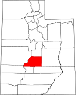
Map of the Sevier County area


Our detail map of Sevier County shows the Sevier County, Utah boundary lines and other interesting items.

Places in Sevier County, Utah

  Airports     show all on map

Richfield Municipal Airport, Salina-Gunnison Airport, Sevier Valley Hospital Heliport

  Areas     show all on map

Beaver Dams, Central Pasture, Smith Overflow, The Pines

  Basins     show all on map

Beanies Hole, Corral Hole, Doe Hole, Garden Basin, Milos Kitchen, Paradise Valley, Prince Valley, Red Creek Hole, Sage Hole, Sevenmile Cirques, Solomon Basin, Steves Basin, The Cove, The Sinks, Willow Basin

  Bays     show all on map

Mallard Bay, Widgeon Bay

  Benches     show all on map

Big Bench, Brome Bench, Coonah Bench, Foy Bench, Horse Bench, Icicle Bench, Ivie Creek Bench, Jones Bench, Rock Springs Bench, Saleratus Benches, Sawmill Bench, Squaw Ledge, Water Hollow Benches

  Buildings     show all on map

Aurora Fire Department, Elsinore Fire Department, Fish Lake Visitor Center, Koosharem Fire Department, Monroe City Fire Department, Richfield Interagency Fire Center, Richfield Police Department, Richfield Volunteer Fire Department, Salina City Police Department, Salina Volunteer Fire Department, Sevier County Ambulance, Sevier County Sheriff's Office, Sigurd Fire Department, Utah Highway Patrol Section 10 Richfield Office

  Canals     show all on map

Annabella Canal, Bertlesen Ditch, Brooklyn Canal, Elisnore Canal, Koosharem Canal, Little Ditch, Monroe Canal, Piute Canal, Prattsville Canal, Richfield Canal, Rocky Ford Canal, Sevier Valley Canal, Sevier Valley Canal, South Bend Canal, Spring Ditch, State Canal, Stone Quarry Ditch, Trunk Ditch, Venice Canal, Vermillion Canal

  Capes     show all on map

Jolly Mill Point, Pelican Point

  Cemeteries     show all on map

Annabella Cemetery, Aurora Cemetery, Burrville Cemetery, East Side Cemetery, Elsinore Cemetery, Glenwood Cemetery, Joseph Cemetery, Koosharem Cemetery, Monroe City Cemetery, Pioneer Cemetery, Redmond Cemetery, Richfield City Cemetery, Salina City Cemetery, Sevier Cemetery, Sigurd Cemetery, Venice Cemetery, Vermillion Cemetery

  Churches     show all on map

Assembly of God Church, Faith Baptist Church, First Baptist Church, Good Shepherd Lutheran Church, Saint Elizabeth Catholic Church, The Church of Jesus Christ of Latter Day Saints, The Church of Jesus Christ of Latter Day Saints, The Church of Jesus Christ of Latter Day Saints, The Church of Jesus Christ of Latter Day Saints, The Church of Jesus Christ of Latter Day Saints, The Church of Jesus Christ of Latter Day Saints, The Church of Jesus Christ of Latter Day Saints, The Church of Jesus Christ of Latter Day Saints, The Church of Jesus Christ of Latter Day Saints, The Church of Jesus Christ of Latter Day Saints, The Church of Jesus Christ of Latter Day Saints, The Church of Jesus Christ of Latter Day Saints, The Church of Jesus Christ of Latter Day Saints, The Church of Jesus Christ of Latter Day Saints, The Church of Jesus Christ of Latter Day Saints, The Church of Jesus Christ of Latter Day Saints, The Church of Jesus Christ of Latter Day Saints, The Church of Jesus Christ of Latter Day Saints, Trinity Baptist Church, Valley Community Presbyterian Church

  Cliffs     show all on map

Devils Castle, Limestone Cliffs, Purgatory, The Brink

  Dams     show all on map

Annabella Dam, Big Lake Reservoir Dam, Boobe Hole Dam, Deep Lake Dam, Denmark Wash Dam, Farnsworth Dam, Forsyth Dam, Johnson Valley Dam, Koosharem Dam, Lost Creek Dam, Magleby Dam, Mud Lake Dam, Redmond Dam, Rex Dam, Rocky Ford Dam, Salina Canyon Dam, Salina Canyon Dam Number 4, Salina City Dam, Sheep Valley Dam, Skutumpah Dam, Soldier Canyon Dam Number 1, Soldier Canyon Dam Number 2, Three Creeks Dam, Willow Creek Dam

  Flats     show all on map

Anthony Flat, Bagley Meadows, Black Flat, Blue Jay Flat, Brindley Flat, Buck Flat, Burnt Hollow, Butterfield Meadow, Cedarless Flat, Central Pasture, Circle Flat, Clay Flats, Clover Flat, Coyote Flat, Danish Meadows, Devils Castle Flat, Devils Dance Floor, Doe Flat, Eagle Flat, East Hunter Flat, Ezras Flat, Fitzgeral Park, Flat Top, Frogs Flat, Frying Pan Flat, Frying Pan Flat, German Flat, Hancock Flat, Hearthstone Flat, Hunters Flat, Jackass Flat, Jacks Flat, Jims Farm, Joseph Flats, Kings Meadow, Kinneys Meadow, Long Flat, Monroe Meadows, Monrovian Park, Mud Flats, Mud Spring Flat, Na-Gah Flat, Neals Flat, Oak Flat, Oak Flat, Pinenuts Flat, Pole Flat, Poverty Flat, Poverty Flat, Rose Meadows, Sage Flat, Sage Flat, Sage Flat, Sage Flat, Salina Flats, Saul Meadow, Sawmill Flat, Scorups Meadows, Scrub Flat, Shingle Creek Meadows, Sign Board Flat, Smithii Flat, Taylor Flat, Taylor Flat, Teah Flat, The Circle, The Frying Pan, Torgerson Flat, Walker Flat, Water Flat, Water Flat, Willies Flat, Zedds Meadows, Zero Flat

  Gaps     show all on map

Daniels Pass, Emigrant Pass, Hogan Pass, Magleby Pass, Sage Flat Divide, Salt Gap, Steves Pass, The Gates, The Narrows, U M Pass, U M Yogo Saddle, Yens Peters Gap

  Hospitals     show all on map

Sevier Valley Medical Center

  Lakes     show all on map

Acord Lakes, Broadhead Lakes, Coots Slough, Crater Lakes, Duck Lake, Emerald Lakes, Farrell Pond, Fish Lake, Floating Island Lake, Hepplers Ponds, Hunts Lakes, Lake Louise, Lower Hunts Lake, Meeks Lake, Morrell Pond, Mud Lake, Oles Pond, Paradise Valley Lake, Sargent Lake, Slide Lake, Snow Fence Pond, Snow Lake, The Potholes, Three Lakes, Tidwell Pond, Twin Lake, Twin Ponds, Willow Lake

  Locales     show all on map

Aspen Heart and Lakeview Recreation Residences, Belknap Ranger Station, Bowery Creek Campground, Bowery Group Area Recreation Site, Bowery Haven, Brooklyn, Butch Cassidy Campground, Castle Rock Campground, Clear Creek Guard Station, Desert View Area, Doctor Creek Campground, Doctor Creek Group Area, Doctor Creek Recreation Residences, Dons Texaco Campground, Durfrey Homestead, Elk Campground, Fish Lake Lodge, Fish Lake Ranger Station, Frying Pan Campground, Glenwood Fish Hatchery, Gooseberry, Gooseberry Campground, Gooseberry Ranger Station, Jensen Place (historical), Joe Bush Fisherman Parking, Johnson Feedlot, Johnson Reservoir Campground, KOA Campground, Koosharem Campground, Koosharem Guard Station, Last Chance Ranch, Lizonbee Administrative Site, Lunds Cabin (historical), Mackinaw Campground, Meadow Gulch Administrative Site, Monrovian Park Campground, Mount Terrill Guard Station, Musinea Administrative Site, Oak Spring Ranch, Okerlund Campground, Old Allridge Place (historical), Pah Ga Ne A Campground, Pahvant Guard Station, Paraboo Campground, Park Crest Village Center, Parker Ranch, Pavant Ranger Station, Peacocks Place (historical), Pelican Overlook, Pelican Point Campground, Piute Campground, Pole Campground, Poverty Flat Ranch, Redview Forest Service Station, Redview Guard Station, Rockwood Ranger Station, Sevier County Fairground, Shingle Creek Ranger Station, Sigurd Substation, Solitude Guard Station, Tasha Recreation Site, The Gates, Toats Campground, Twin Creek Amphitheater Recreation Site, White Mountain Cabin, White Pine Cabins, Zedds Campground

  Mines     show all on map

Antelope Mine, BW and H Mine, Convulsion Coal Mine, Knight Mine (historical), Link Canyon Mine

  Parks     show all on map

Bowery Haven Resort, Fremont Indian State Park, Koosharem Reservoir Recreation Site, Monroe Hot Springs Resort, Salina Creek RV and Camp, Sand Ledges Recreation Area, Sevier River Bend Recreation Site, Twin Creek Picnic Area

  Pillars     show all on map

Jack Adley Monument, The Rocks

  Plains     show all on map

Fish Lake Hightop Plateau, Last Chance Desert, Old Woman Plateau, U M Plateau

  Populated Places     show all on map

Annabella, Aurora, Austin, Belknap, Burrville, Central Valley, Cove, Elsinore, Fishlake Resort, Fremont Junction, Glenwood, Gramse, Jensen, Joseph, Kema, Koosharem, Lakeside Resort, Monroe, Nibley, Prattsville, Redmond, Richfield, Salina, Sevier, Sigurd, Venice, Vermillion, Whipup

  Post Offices     show all on map

Annabella Post Office, Aurora Post Office, Elsinore Post Office, Monroe Post Office, Richfield Post Office, Salina Post Office

  Ranges     show all on map

Bald Knolls

  Reservoirs     show all on map

Abes Reservoir, Annabella Reservoir, Bear Valley Reservoir, Big Lake, Boobe Hole Reservoir, Davis Hollow Reservoir, Deep Lake, Farnsworth Reservoir, Forsyth Reservoir, Gardner Hollow Reservoirs, Gates Lake, Hamilton Reservoir, Harves River Reservoir, Jeffery Reservoir, Johnson Valley Reservoir, Koosharem Reservoir, Lost Creek Reservoir, Magelby Reservoir, Mill Meadow Reservoir, Mud Lake, Mud Lake, Redmond Lake, Rex Reservoir, Rocky Ford Reservoir, Saleratus Reservoir, Salina Reservoir, Scrub Flat Reservoir, Sheep Valley Reservoir, Skutumpah Reservoir, Solomon Reservoir, Spring Reservoir, Three Creeks Reservoir, Twin Ponds, Washburn Reservoir, Willies Flat Reservoir, Willow Creek Reservoir, Willow Creek Reservoir, Wood Hollow Reservoir

  Ridges     show all on map

Bell Rock Ridge, Big Ridge, Dead Horse Ridge, Doe Ridge, Lone Pine Ridge, Mahogany Ridge, Meadow Gulch Divide, Monkey Flat Ridge, Nightgown Ridge, Oak Ridge, Red Pine Ridge, Rock Springs Ridge, S B Ridge, Sheep Valley Ridge, Snow Corral Ridge, South Ridge, Tabernacle Ridge, Tenderfoot Ridge, Water Hollow Ridge, Windy Ridge

  Schools     show all on map

Ashman School, Koosharem School, Monroe School, North Sevier High School, North Sevier Middle School, Pahvant School, Red Hills Middle School, Salina School, South Sevier Middle School

  Slopes     show all on map

Praetor Slopes, Tidwell Slopes

  Springs     show all on map

Anderson Spring, Birch Spring, Birch Spring, Birch Springs, Brimhall Springs, Bronco Spring, Bull Spring, Burr Springs, Butler Spring, Carter Spring, Christensen Spring, Christiersen Spring, Cold Spring, Cold Spring, Conservation Spring, Cottonwood Spring, Creepy Spring, Crevice Spring, Deer Spring, Deer Spring, Duncan Draw Spring, East Tidwell Spring, Elbow Spring, Fairy Spring, Fallon Spring, First Spring, Flowell Spirng, Forsyth Springs, Gahew Spring, Glenwood Spring, Hancock Spring, Hearthstone Spring, Hi Spring, Hot Springs, Hot Springs, Hot Springs, Hunters Spring, Indian Springs, Jensen Spring, Josiah Springs, Kasov Spring, Killian Spring, Kinney Spring, Kinnikinnick Spring, Koosharem Pasture Spring, Little Valley Spring, Lizonbee Springs, Lone Pine Spring, Lone Pine Spring, Lower Horse Hollow Spring, Mamoits Spring, Maple Spring, Mud Spring, Mud Spring, Mud Spring, Mud Spring, Mud Spring, Mud Spring, Mud Spring, Mud Spring, Niel Spring, North Spring, Oak Spring, Oak Spring, Ox Spring, Parcell Spring, Pine Spring, Pipe Spring, Pipe Springs, Pond Spring, Porcupine Spring, Praetor Spring, Prous Spring, Prowse Spring, Reflection Spring, Riley Spring, Rim Seep, Rock Spring, Rock Spring, Rose Spring, Ross Spring, Round Spring, Rust Spring, Salina City Spring, Sawmill Spring, Shoap Spring, Sidehill Spring, Silas Spring, Skutumpah Spring, Spirit Spring, Stag Spring, Summit Spring, Swamp Spring, Sweet Water Spring, Tasha Spring, Teeples Spring, Toats Spring, Torgerson Spring, Travois Spring, Upper Horse Hollow Spring, Washburn Spring, West Tidwell Spring, Whiskey Spring, Whooton Spring, Widgeon Spring, Wigwam Spring, Wikieup Spring, Willow Spring, Willow Spring, Willow Springs

  Streams     show all on map

Abes Creek, Anderson Creek, Beaver Creek, Beaver Creek, Birch Creek, Birch Creek, Birch Creek, Black Fork Creek, Blackham Creek, Boobe Hole Creek, Bowery Creek, Brine Creek, Burr Creek, Clear Creek, Clear Creek, Clear Creek, Coal Mine Creek, Coldwater Creek, Commissary Creek, Cottonwood Creek, Cottonwood Creek, Cottonwood Creek, Cove River, Cowboy Creek, Coyote Hollow Creek, Currant Creek, Daniels Creek, Doxford Creek, Draw Creek, Dry Creek, Dry Fork, East Fork Beaver Creek, East Fork Picklekeg Creek, East Fork Quitchupah Creek, First Lefthand Fork, Fish Creek, Gates Creek, Gooseberry Creek, Gooseberry Creek, Gooseberry Creek, Gottfredsen Creek, Grass Creek, Hoodoo Creek, Horse Fork, Humphrey Spring, Indian Creek, Jackass Creek, Jacks Creek, Joe Lott Creek, Jorgenson Creek, Jump Creek, Koosharem Creek, Lake Creek, Last Chance Creek, Last Water, Left Fork Sam Stowe Creek, Left Fork U M Creek, Link Canyon Wash, Little Creek, Little Creek, Little Lost Creek, Lost Creek, Magpie Creek, Maple Creek, Meadow Creek, Mill Creek, Mill Creek, Mill Creek, Mill Creek, Mill Fork Creek, Monkey Fork Dry Canyon, Monroe Creek, Mortensen Creek, Niotche Creek, North Creek, North Creek, North Fork Clear Creek, North Fork Quitchupah Creek, North Fork Three Creeks, North Fork Willow Creek, North Last Chance Creek, North South Creek, Norton Creek, Oak Flat Creek, Oak Spring Creek, Peterson Creek, Picklekeg Creek, Pine Creek, Pine Creek, Pole Creek, Porcupine Creek, Red Creek, Reservoir Creek, Right Fork U M Creek, Rosebud Creek, Saleratus Creek, Salina Creek, Sam Stowe Creek, Sanford Spring, Santa Fe Creek, Sawmill Creek, Second Lefthand Fork, Serviceberry Creek, Serviceberry Creek, Sevenmile Creek, Sheep Creek, Shingle Creek, Shingle Creek, Short Creek, Skunk Creek, Skutumpah Creek, Slide Fork, Solomon Creek, South Fork Monroe Creek, South Fork North Fork Quitchupah Creek, South Fork Pine Creek, South Fork Willow Creek, South Last Chance Creek, South Willow Creek Fork, Spring Creek, Sweet Water Creek, Tasha Creek, Third Lefthand Fork, Thompson Creek, Three Creeks, Thurber Fork, Trough Hollow Creek, Twin Creek, U M Creek, Water Creek, West Beaver Creek, West Fork Beaver Creek, West Fork Joe Lott Creek, Whiskey Spring Creek, White Creek, White Pine Creek, Willow Creek, Willow Creek, Willow Springs, Wine Creek, Yogo Creek

  Summits     show all on map

Alice Mount, Antelope Range, Bald Hill, Bald Knoll, Beehive Peak, Black Cap Mountain, Black Knoll, Black Mountain, Black Mountain, Blue Peak, Boobe Hole Mountain, Bull Claim Hill, Bull Valley Mountain, Carter Peak, Cedar Mountain, Cedar Mountain, Corral Knoll, Cove Mountain, Deer Peak, Devils Dutch Oven, Duncan Mountain, East Mountain, First Red Knoll, Flat Top Mountain, Geyser Peak, Glenwood Mountain, Granddad Peak, Hilgard Mountain, Indian Peak, Johns Peak, Joseph Peak, Kinneys Peak, Lion Peak, Little Deer Peak, Little Duncan Mountain, Middle Mountain, Monroe Peak, Monument Hill, Monument Peak, Mormon Mountain, Moroni Peak, Mount Marvine, Mount Terrill, Mytoge Mountains, Oscars Vision, Pa'hvant Mountain, Pole Hill, Rainbow Hills, Rattlesnake Point, Reservoir Hill, Sargent Mountain, Sawtooth, Second Red Knoll, Signal Peak, Solomons Temple, Steves Mountain, Table Mountain, The Stone Quarry, The Twist, Third Red Knoll, Trail Mountain, Triangle Mountain, Whiskey Knoll, White Mountain, Wildcat Knolls, Windstorm Peak, Windy Peak, Zedds Mountain

  Towers     show all on map

KKWZ-FM (Richfield), KSVC-AM (Richfield)

  Trails     show all on map

Great Western Trail, Koosharem Guard Station Scrub Flat Trail, Meadow Gulch Salt Gulch Trail, Oak Belt Trail, Rocky Trail, Second Lefthand Fork Trail, Serviceberry Trail, Third Lefthand Fork Trail, Winkel Bob Trail

  Valleys     show all on map

Albinus Canyon, Alumbed Hollow, Antelope Valley, Antone Hollow, Aspen Hollow, Aspen Hollow, Bald Knoll Canyon, Balsam Hollow, Bean Canyon, Bear Canyon, Bear Gulch, Bear Valley, Bell Rock Canyon, Bertlesen Canyon, Box Canyon, Briggs Hollow, Broad Hollow, Browns Hole, Brush Trail Hollow, Burnt Hollow, Catamount Canyon, Charlesworth Valley, Chicken Gulch, Chokecherry Hollow, Clear Creek Canyon, Cliff Canyon, Coal Hollow, Collier Hollow, Convulsion Canyon, Coonah Swale, Corner Spring Canyon, Corral Canyon, Culvert Hollow, Daniels Canyon, Davis Hollow, Dead Horse Canyon, Deer Spring Draw, Dell Lott Hollow, Denmark Wash, Dipping Vat Draw, Doctor Canyon, Dry Canyon, Dry Hollow, Dry Hollow, Dry Red Canyon, Dry Wash, Duncan Draw, East Fork Box Canyon, East Spring Canyon, East Tidwell Canyon, Eldridge Hollow, First Spring Hollow, Flat Canyon, Gardner Hollow, Gilson Valley, Gooseberry Valley, Grand Gorge, Graveyard Hollow, Greens Canyon, Greens Hollow, Gunnison Valley, Henries Hollow, Hock Swale, Horse Hollow, Horseshoe Hollow, Indian Canyon, Ivie Canyon, Jack Went Hollow, Jensen Canyon, Jolly Mill Hollow, Kennedy Fork, Killian Hollow, Kings Meadow Canyon, Kumo Valley, Lagoon, Left Fork Sam Stowe Canyon, Lewis Hollow, Link Canyon, Little Valley, Live Oak Canyon, Lone Pine Canyon, Long Hollow, Long Valley, Long Valley, Maple Spring Canyon, Maple Spring Hollow, Marysvale Canyon, May Hollow, Middle Fork Amos Canyon, Mill Canyon, Mill Hollow, Mud Hollow, Mud Spring Hollow, Mud Spring Hollow, Newts Canyon, Nielsen Canyon, North Cedar Ridge Canyon, North Fork Indian Canyon, North Fork Rock Canyon, North Fork Willow Creek Canyon, North Hollow, North Water Hollow, Oak Creek Canyon, Oak Hollow, Oak Hollow, Oak Spring Hollow, Oak Spring Hollow, Order Dugway Canyon, Pelican Canyon, Petes Hole, Pin Hollow, Pine Hollow, Pine Hollow, Plateau Valley, Pole Canyon, Pole Hollow, Porcupine Draw, Post Hollow, Post Hollow, Post Hollow, Praetor Canyon, Raphaelsen Canyon, Red Butte Canyon, Red Canyon, Red Narrows, Road Hollow, Rock Canyon, Rock Canyon, Rock Canyon, Rock Hollow, Rocky Hollow, Round Spring Draw, Saddlehorse Canyon, Sam Stowe Canyon, Sand Canyon, Sevier Valley, Sheep Valley, Sid Carter Hollow, Skinner Canyon, Skinner Hollow, Skougaard Canyon, Skutumpah Canyon, Snow Canyon, Soldier Canyon, South Cedar Ridge Canyon, South Fork Rock Canyon, South Fork Willow Creek Canyon, South Water Hollow, Splatter Canyon, Splatter Drip Canyon, Spring Canyon, Squaw Hollow, Squeedunk Canyon, Steves Wash, Strawberry Canyon, Sweetwater Canyon, Telephone Hollow, The Box, The Troughs, Tommy Hollow, Trail Mountain Hollow, Trough Canyon, Trough Hollow, Trunk Canyon, Twist Canyon, Twist Canyon, Water Creek Canyon, Water Hollow, Water Hollow, Water Hollow, West Tidwell Canyon, Wide Hollow, Wide Hollow, Willow Creek Canyon, Winget Canyon, Wood Hollow, Yopa Swale

  Woods     show all on map

North Cedars, The Pines,

Sevier County, Utah Population By Race (2012 estimate)

RacePopulation
WhiteSevier County White population 20,04320,043  
American IndianSevier County American Indian population 269269
MixedSevier County Mixed population 249248
AsianSevier County Asian population 8382
Hawaiian & Pacific IslanderSevier County Hawaiian & Pacific Islander population 4141

Additional population tables :
State population table
Utah population by county