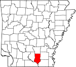
Bradley County, Arkansas Basics:
Bradley County Arkansas - Government Site
Population: 11,352
Area: 649 square miles
County seat: Warren
Area code(s) in use: 870
Time zone: CST
High school graduate or higher: 74.5%
Bachelor's degree or higher: 11.3%
Median household income: $32,321
Persons in poverty: 25.8%
Home ownership rate: 69.4%
Mean travel time to work: 18.5 minutes
Adjacent counties:
Ashley Calhoun Cleveland Drew Lincoln Union
Places in Bradley County, Arkansas
Bradley County Memorial Hospital Heliport,
Warren Municipal Airport Green Island,
Kemp Island,
The Prairie Germany Bay,
Little Bay,
Robinson Bay Caney Marais Bend,
Jacks Island Bend,
Oxbow Bend,
Romeo Cut,
Round Turn,
Staveyard Bend,
Stormhole Bend Arkansas State Police Troop F,
Banks Volunteer Fire Department,
Bradley County Courthouse,
Bradley County Sheriff's Office,
Bradley County Volunteer Fire Department,
County Line Volunteer Fire Station 1,
Emergency Ambulance Service Warren,
Godfrey Volunteer Fire Station,
Hermitage Police Department,
Hermitage Rural Fire Department,
Jersey Rural Fire Department,
Pleasantville Rural Volunteer Fire Department,
Sumpter Rural Fire Station,
Warren Fire Station 1,
Warren Fire Station 2,
Warren Police Department A T Cemetery,
Adams/Singer Cemetery, Akins Cemetery, Anderson-York Cemetery,
Beard Cemetery,
Belin Cemetery, Brooks-Hughey Cemetery, Bull Cemetery,
Calvary Presbyterian Cemetery,
Childs Cemetery,
Coker Cemetery,
Corinth-O'Neil Cemetery,
Craney Cemetery,
Crossroads Cemetery,
Ebenezer Cemetery,
Garrison Cemetery,
Good Hope Methodist Church Cemetery, Gravel Ridge Cemetery,
Gravelridge Cemetery, Hall Cemetery, Hall Wardlaw Cemetery,
Hampton Chapel Cemetery, Hargis Cemetery,
Hickory Springs Cemetery,
Hilo Cemetery,
Hines Cemetery,
Holly Springs Cemetery,
Johnsville Cemetery,
Lavilliam Cemetery,
Lyns Cemetery,
Marsden Cemetery,
McFarland Cemetery,
McKenney Cemetery,
McKinney Cemetery,
McLeod Cemetery, Moro Bay Cemetery,
Moseley Cemetery,
Mount Olive Cemetery,
Mount Zion Cemetery,
Neal Cemetery, New Liberty Cemetery, O'Neil Cemetery,
Oakland Cemetery, Old Warren Cemetery, Outlaw Cemetery,
Palestine Cemetery,
Parker Cemetery,
Parnell Cemetery,
Pattsville Cemetery, Pennington Cemetery,
Pleasant Valley Cemetery, Prospect Cemetery,
Reaves Cemetery,
Saint Paul Cemetery,
Saline Cemetery, Scobey Cemetery,
Seay Cemetery,
Shady Grove Cemetery,
Smearny Cemetery,
Smith Cemetery, Smith's Chapel Cemetery, Smyrna Cemetery,
Union Cemetery,
Union Hill Cemetery, Wardlaw Cemetery, Ware Cemetery, Watkins Cemetery,
Weary Rest Cemetery,
Wheeler Springs Cemetery,
Williams Cemetery,
Willoughby Cemetery,
York Cemetery Antioch Baptist Church,
Antioch Chapel (historical),
Antioch Church,
Antioch Church,
At Church,
Blue Springs Church,
Calvary Presbyterian Church,
Carmel Church (historical),
Church of God in Christ,
Corinth Baptist Church,
Cross Roads Baptist Church,
Crossroads Baptist Church,
Eagle Lake Church,
Ebenezer Baptist Church,
Fair View Church,
Farmville Missionary Baptist Church,
Good Hope Methodist Church,
Green Hill Church (historical),
Greens Chapel (historical),
Hampton Chapel African Methodist Episcopal Church,
Harmony Baptist Church,
Hickory Springs Presbyterian Church,
Hilo Church,
Hopewell Baptist Church,
Jersey Methodist Church,
Landmark Missionary Baptist Church,
Macedonia Baptist Church,
Marsden Baptist Church,
Marsden Methodist Church,
Moro Bay First Methodist Episcopal Church,
Moseley Chapel,
Mount Olive Church,
Mount Zion Baptist Church,
Mount Zion Baptist Church,
Oaklawn Church,
Palestine Methodist Church,
Pleasant Grove Baptist Church,
Pleasant Hill Church,
Pleasant Valley Church,
Primitive Baptist Church,
Primitive Baptist Church,
Saint Matthew Church,
Saint Paul Church,
Saline Baptist Church,
Shady Grove Missionary Baptist Church,
Springhill Freewill Baptist Church,
Sumpter Methodist Church,
Union Hill Baptist Church,
United Church,
Wagnon Methodist Church,
Wearied Rest Church,
Wheeler Springs Methodist Episcopal Church,
Willoughby Baptist Church,
Wilson Chapel Bailey Ford,
Bradley Ford,
Long View Ferry (historical),
Mill Ford,
Suttons Ferry (historical) Atkins Pond Dam,
Bradley County Lake Dam,
Fullerton Lake Dam,
Reeps Lake Dam,
Scott Lake Dam,
Warren Country Club Lake Dam Pin Oak Flat,
Pin Oak Flat,
Pine Prairie,
River Island Crosstie Slough,
Deep Slough,
Green Slough,
Old River,
Pat Slough,
Paw Paw Slough,
Sand Slough,
Spring Slough,
Spring Slu Bradley County Medical Center Berry Island (historical),
Horton Island,
Jacks Island,
Pig Island,
Pine Island Bend Lake,
Bilbo Lake,
Black Lake,
Black Lake,
Buck Lake,
Eagle Lake,
Frank Lake,
Gar Lake,
Green Lake,
Middle Lake,
Moro Bay,
Mud Lake,
Pereogeethe Lake,
Pine Prairie Bay,
Raymond Lake,
Scott Water,
Straight Lake,
Tulip Lake (historical),
White Oak Lake Alta Junction,
Bogalusa Camp,
Carey Junction (historical),
Cornish Landing,
Hudspeth Landing,
Prairie Island Log,
Rubes Landing,
Town and Country Shopping Center,
Tuckers Camp (historical),
Warren Country Club,
Warren Shopping Center Careyville Landing Oil Field Moro Bay State Park Banks,
Blanchton,
Blue Springs (historical),
Broad,
Carmel,
Castleberry (historical),
Cloquet (historical),
Corinth,
Craney,
Cross Roads,
Draper (historical),
Farmville,
Ferrell (historical),
Geopel (historical),
Gin (historical),
Glynn (historical),
Godfrey Landing,
Gravelridge,
Greenville,
Hermitage,
Hilo,
Ingalls,
Jersey,
Johnsville,
Lacy (historical),
Lanark,
Longview,
Mannstown,
Marsden,
McKinney,
Moores Mill,
Moro Bay,
Mount Olive,
Pattsville,
Pine Island Landing,
Pirlte (historical),
Saline (historical),
Sandtuck (historical),
Simpson,
Smearny,
Sturgis (historical),
Sumpter,
Vick,
Wagnon,
Warren,
Weeks,
Wilcox (historical) Cavaness Landing Post Office (historical)
Atkins Pond,
Bradley County Lake,
Fullerton Lake,
Reeps Lake,
Scott Lake,
Warren Country Club Lake Cedar Ridge,
Garrett Ridge,
Hayes Ridge,
Hogpen Ridge,
Hurricane Ridge,
Hurricane Ridge,
Oak Ridge,
Russell Camp Ridge,
Sand Ridge Beard School (historical),
Bradley High School,
Carmel School (historical), Centennial Baptist Academy (historical),
Center Point School (historical),
Center Ridge School (historical),
Child School,
Colvin School (historical),
Corinth School (historical),
Crossroads School (historical),
Eastside Elementary School,
Eastside Primary School,
Ebenezer School (historical),
Farmville School (historical),
Gravelridge School (historical),
Harmony School (historical),
Hermitage Elementary School,
Hermitage High School,
Hickory Springs School (historical),
Hilo School (historical),
Hopewell School (historical), Jeffrey School (historical),
Jersey School,
Lanark School (historical),
New Hope School (historical),
Newton School (historical),
North Oak Grove School (historical),
Oakdale School (historical),
Pleasant Ridge School (historical),
Pleasant Valley School (historical),
Prospect School (historical),
Riverside School (historical),
Saline School (historical),
South Oak Grove School (historical),
Spring Hill School (historical),
Sunnyside School (historical),
Thomas C Brunson Elementary School,
Thomas School (historical),
Warren High School,
Warren Middle School,
Westside Elementary School,
Williford School (historical),
Willoughby School (historical) Blue Springs,
Mud Springs,
Parnell Springs Basin Creek,
Beech Creek,
Beech Creek,
Beech Creek,
Berry Creek,
Big Slough,
Blue Springs Branch,
Boyd Branch,
Bradley Creek,
Bradley Creek,
Brooks Creek,
Brown Branch,
Brushy Branch,
Brushy L'Aigle Creek,
Buckhead Creek,
California Branch,
Camp Creek,
Caney Branch,
Caney Creek,
Caney Creek,
Carmichael Creek,
Charivari Creek,
Claret Branch,
Crane Creek,
Flat Branch,
Franklin Creek,
Germany Creek,
Gin House Branch,
Gin House Slough,
Grassy Pond Creek,
Gravelly Branch,
Gray Branch,
Halfway Creek,
Hall Branch,
Henrys Creek,
Highbank Branch,
Hollis Creek,
Hunt Branch,
Hunter Branch,
Hurricane Branch,
Improvement Creek,
Irish Bill Creek,
Jordan Branch,
L'Aigle Creek,
LaBaum Creek,
Langford Creek,
Lavender Branch,
Lay Branch,
Lee Branch,
Little Snake Creek,
Log Slough,
Meeks Branch,
Mill Branch,
Mill Branch,
Mill Creek,
Mill Creek,
Mill Creek,
Miller Branch,
Mobley Branch,
Moro Creek,
Old River,
Parr Branch,
Robinson Branch,
Rocky Branch,
Seay Creek,
Singleton Creek,
Snake Creek,
Springhill Creek,
Steepbank L'Aigle Creek,
Sulphur Branch,
Tenmile Creek,
Thompson Creek,
Threemile Branch,
Town Branch,
Town Branch,
Tulip Creek,
Villum Branch,
Wagnon Branch,
Wahl Branch,
Walker Creek,
Walnut Creek,
Wheeler Branch,
White Oak Creek,
Whitewater Creek Cane Hill Short Brake Banks Lookout Tower,
KWRF-AM (Warren),
KWRF-FM (Warren) Duncan Brake,

