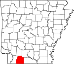
Columbia County, Arkansas Basics:


Columbia County Arkansas - Government Site

Population: 24,386
Area: 766 square miles
County seat: Magnolia
Area code(s) in use: 870
Time zone: CST
High school graduate or higher: 84.5%
Bachelor's degree or higher: 19.1%
Median household income: $34,895
Persons in poverty: 24.7%
Home ownership rate: 71.2%
Mean travel time to work: 17.5 minutes


Adjacent counties:
Bossier (LA)  Claiborne (LA)  Lafayette  Nevada  Ouachita  Union  Webster (LA)  
Find in Arkansas

Map of the Columbia County area


Our detail map of Columbia County shows the Columbia County, Arkansas boundary lines and other interesting items.

Places in Columbia County, Arkansas

  Airports     show all on map

Magnolia Hospital Heliport, Magnolia Municipal Airport

  Bridges     show all on map

Jameson Bridge

  Buildings     show all on map

Asa G Garrett Memorial Library, Bussey - Sharman Fire Station, Calhoun Community Volunteer Fire Department, Columbia County Ambulance Service, Columbia County Courthouse, Columbia County Jail, Columbia County Sheriff's Office, Emerson Volunteer Fire Department, Four Communities Volunteer Fire Department Station 1, Four Communities Volunteer Fire Department Substation, Highway 79 South Fire Department, Jimmy Jones Community Center, Macedonia / Dorcheat Fire Station 1, Macedonia / Dorcheat Station 2, Magnolia Housing Authority, Magnolia Police Department, Magnolia Volunteer Fire Department, McNeil Fire Station, Mount Vernon Volunteer Fire Department, Rudd Crossing Volunteer Fire Department, Southern Arkansas University Police Department, Taylor Volunteer Fire Department, Village Volunteer Fire Department, Waldo Fire Department, Waldo Police Department, Walkerville Volunteer Fire Department

  Cemeteries     show all on map

Anderson Cemetery, Antioch Cemetery, Baker Cemetery, Barlow Cemetery, Bethel Cemetery, Big Hickory Cemetery, Chalybeate Springs Cemetery, Columbia Cemetery, Dickson Cemetery, Elliott Cemetery, Forest Grove Cemetery, Frazier Cemetery, Free Hope Cemetery, Friendship Cemetery, Gatlin Cemetery, Glover Cemetery, Green Cemetery, Hartsfield Cemetery, Jameson Cemetery, Jerusalem Cemetery, Kings Hill Cemetery, Macedonia Cemetery, Macedonia Cemetery, Magnolia Cemetery, Magnolia Memorial Park, McClendon Cemetery, Memorial Gardens, Miller Cemetery, Miner Cemetery, New Bethel Cemetery, New Hope Cemetery, Old Bethel-Saint John Cemetery, Owen Cemetery, Patterson Cemetery, Providence Cemetery, Rocky Mount Cemetery, Rudd Cemetery, Saint Marks Cemetery, Saint Matthews Cemetery, Scott Cemetery, Sharman Cemetery, Shiloh Cemetery, Stewart-Walkerville Cemetery, Strong Cemetery, Traylor Cemetery, Waldo Cemetery

  Churches     show all on map

Antioch Church, Antioch Church, Antioch West Church, Asbury United Methodist Church, Barges Chapel (historical), Beacon Church, Beech Creek Church, Beech Hill Church, Bethel Church, Bethel Church (historical), Bethlehem Church, Canaan Land Church, Cedar Grove Baptist Church, Central Baptist Church, Chalybeate Springs Church (historical), Christie Chapel United Methodist Church, Church of Christ, Corinth Church, Corinth Church, Cross Roads Church (historical), Damascus Church, Davis Church, Doss Chapel, Early View Church, Ebenezer United Methodist Church, Emerson Chapel (historical), Emerson Church, First Baptist Church, First Missionary Baptist Church, First United Methodist Church, Forest Grove Church, Free Hope Church, Friendship Church, Friendship Church, Friendship Church, Greers Church, Harmony United Methodist Church, Heard Chapel, Hephzibah Church, Hickory Hill Church (historical), Homnear Church, Kilgore Lodge Church, Kings Hill Church, Kings Hill Church (historical), Laughlin Church, Ledesdale Church, Little Flock Church (historical), Logans Chapel (historical), Longview Church (historical), Macedonia Church, Macedonia Church, Macedonia Church, Macedonia Church (historical), Memorial Baptist Church, Mount Bethel Church, Mount Carmel Church, Mount Israel Church, Mount Pisgah United Methodist Church, Mount Pleasant Church, Mount Prospect Methodist Church, Mount Superior Church, Mount Vernon Church, Mount Zion Church, New Bethel Church, New Bethel Church (historical), New Era United Methodist Church, New Hope Church, New Hope Church (historical), New Hope Number 1 Church, New Prospect Church (historical), New Zion Church, Philadelphia United Methodist Church, Pilgrims Rest Church, Pine Grove Church, Pine Hill Church, Piney Grove Church, Pleasant Hill Church, Pleasant Home Church, Porter Chapel, Providence Church (historical), Roadside Church, Rocky Mount Church, Saint James Church, Saint John Church, Saint John II Baptist Church, Saint Johns Church (historical), Saint Lukes Church, Saint Marks Church, Saint Marks Church (historical), Saint Matthew Church (historical), Saint Matthews Church, Saint Paul Church, Salem Church, Salem Church (historical), Shady Grove Church, Sharman Church, Shiloh Church, Smyrna Church, Sobers Chapel (historical), Spring Branch Church, Sweet Home Church, Union Chapel (historical), Union Church (historical), Vernon Chapel, Victory Church, Waldo Church of Christ, Wares Chapel United Methodist Church, Washington Chapel, Welcome United Methodist Church, Western Missionary Church, Westside Baptist Church, Wingfield Church, Woodward Chapel (historical), Zion Church (historical)

  Crossings     show all on map

Courtneys Ford, Lecroys Ford

  Dams     show all on map

Arkansas Louisiana Gas Lake Dam, Arkansas Noname 62 Dam, Bearden Lake Dam, Byrd Lake Dam, Fallin Lake Dam, Fincher Lake Dam, Foster Dam, Lake Sue Dam, Maloch Lake Dam, Miller Lake Dam, Pittman Lake Dam, Powell Lake Dam, Rasberry Lake Dam, Sale Lake Dam, Weber Lake Dam, Wilson Lake Dam

  Hospitals     show all on map

Magnolia Regional Medical Center

  Locales     show all on map

Columbia Shopping Center, Frog Level Plantation, Kilgore Lodge, Magnolia Country Club, McCalls Gin (historical), Rucks Spur

  Oilfields     show all on map

Atlanta Oil and Gas Field, Big Creek Oil and Gas Field, Buckner Oil and Gas Field, Calhoun Oil and Gas Field, College Hill Oil and Gas Field, Columbia Oil and Gas Field, Dorcheat Macedonia Oil Field, East McNeil Oil and Gas Field, Haynesville Oil Field, Horsehead Oil Field, Magnolia Oil and Gas Field, Pine Tree Oil and Gas Field, Village Oil and Gas Field, Warnock Springs Oil and Gas Field

  Parks     show all on map

Eastside Park, Hospital Park, Logoly State Park, Mulerider Stadium, Southside Park, West Side Park

  Populated Places     show all on map

Atlanta, Beech Creek, Bethel, Box Springs, Bright, Brister, Bussey, Calhoun, Calhoun Junction, Calico Neck (historical), College Hill, Damascus, Dodson, Ebenezer, Emerson, Emon, Experiment, Forest Grove, Free Hope, Friendship, Harmony, Horsehead, Hunt, Jefferson, Johnston, Kerlin, Lamartine, Laughlin, Lumber, Lydesdale, Macedonia, Magnesia Springs, Magnolia, McNeil, Medlock, Milner (historical), Mohawk, Mount Vernon, Noxobe, Owens, Partee, Philadelphia, Plainfield, Rocky Mound, Saint Matthews, Sharman, Shiloh, Smithland, Snipe, Spotville, Talley, Taylor, Tide Water, Village, Village Junction, Waldo, Walker, Walkerville, Walnut Grove, Ware, Warnock Springs, Welcome, Western

  Post Offices     show all on map

Beaver Ruin Post Office (historical), Magnesia Post Office (historical), Magnolia Post Office, Village Post Office

  Reservoirs     show all on map

Arkansas Louisiana Gas Lake, Bearden Lake, Byrd Lake, Dupriest Lake, Fallin Lake, Fincher Lake, Foster Lake, Lake Columbia, Lake Sue, Maloch Lake, Miller Lake, Pittman Lake, Powell Lake, Rasberry Lake, Sale Lake, Weber Lake, Wilson Lake

  Schools     show all on map

Antioch School (historical), Beech Grove School (historical), Beech Hill School (historical), Buena Vista School (historical), Burden School (historical), Calhoun Heights School, Calico Neck School (historical), Cedar Grove School (historical), Center Point School (historical), Center Point School (historical), Central Elementary School, Cleveland School (historical), Columbia High School, Coopers School (historical), Cross Roads School (historical), Damascus High School, East-West Elementary School, Eastside School, Emerson Elementary School, Emerson High School, Fears School (historical), Forest Grove School (historical), Grace Christian Academy, Green School (historical), Greers School (historical), Harpers School (historical), Harvey Couch High School (historical), Holly Grove School (historical), Home Near School (historical), Hopewell School (historical), Horsehead School (historical), Lone Beach School (historical), Macedonia School, Magnolia High School, Magnolia Junior High School, McNeil Elementary School, McNeil High School, Mcneil High School, Miller School (historical), Milner School (historical), Mount Pleasant School (historical), Mount Pleasant School (historical), Nebo School (historical), New Vernon School (historical), Pine Forest School (historical), Pine Grove School (historical), Pisgah School (historical), Robertson School (historical), Rocky Mound School (historical), Rocky Mound School (historical), Sand Ridge School (historical), Sanders School (historical), Southern Arkansas University, Spotville School (historical), State Line School (historical), Talley School (historical), Taylor Elementary School, Taylor High School, Valley School (historical), Waldo Elementary School, Waldo High School, Walker Elementary School, Walker High School, Walker Pre-K Center, Walkers School (historical), Walnut Grove School (historical), Westside School, Westside School, Wilburn School (historical), Willow Spring School (historical), Wise School (historical), Wood School (historical), Woodard School

  Springs     show all on map

Magnesia Springs, Warnock Springs

  Streams     show all on map

Atkinson Branch, Bailey Branch, Baker Branch, Ballard Branch, Barlow Branch, Beech Creek, Beech Creek, Beene Creek, Big Creek, Birchfield Creek, Black Branch, Blake Creek, Bob Branch, Bond Creek, Bridge Creek, Brushy Branch, Brushy Branch, Chaffin Branch, Chalybeate Springs Branch, Christies Branch, Cypress Creek, Davis Branch, Dismukes Branch, Dodson Creek, Dry Creek, Dry Fork, Ebenezer Branch, Green Creek, Harper Creek, Henderson Creek, Holly Creek, Honduras Branch, Horsehead Creek, Hurricane Creek, Hurricane Creek, Kendrick Creek, Kings Creek, Little Cornie Bayou, Little Crooked Creek, Little Cypress Creek, McLendon Branch, Mill Creek, Mill Creek, Mill Creek, Nations Creek, North Cypress Creek, O'Rear Creek, Otter Creek, Panther Branch, Patterson Creek, Pigeon Roost Creek, Pretty Branch, Red Water Branch, Riley Branch, Sand Creek, Sassafras Creek, Scott Branch, Sloan Creek, Slow Motion Creek, Smackover Creek, South Creek, South Cypress Creek, Spring Branch, Spring Branch, Spring Branch, Sylvester Branch, Tanyard Branch, Taylor Branch, Village Creek, Ware Creek, White Oak Branch, White Oak Creek, Wynn Creek

  Towers     show all on map

KVMA-AM (Magnolia), KVMA-FM (Magnolia), Waldo Water Tower,

Columbia County, Arkansas Population By Race (2012 estimate)

RacePopulation
WhiteColumbia County White population 14,94914,948  
BlackColumbia County Black population 8,8778,876
MixedColumbia County Mixed population 244243
AsianColumbia County Asian population 195195
American IndianColumbia County American Indian population 9897
Hawaiian & Pacific IslanderColumbia County Hawaiian & Pacific Islander population 00

Additional population tables :
State population table
Arkansas population by county