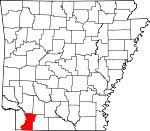
Lafayette County, Arkansas Basics:


Lafayette County Arkansas - Government Site

Population: 7,423
Area: 528 square miles
County seat: Lewisville
Area code(s) in use: 870
Time zone: CST
High school graduate or higher: 76.0%
Bachelor's degree or higher: 12.0%
Median household income: $28,633
Persons in poverty: 22.9%
Home ownership rate: 73.4%
Mean travel time to work: 23.5 minutes


Adjacent counties:
Bossier (LA)  Caddo (LA)  Columbia  Hempstead  Miller  Nevada  Webster (LA)  

Find in Arkansas

Map of the Lafayette County area


Our detail map of Lafayette County shows the Lafayette County, Arkansas boundary lines and other interesting items.

Places in Lafayette County, Arkansas

  Bends     show all on map

Slay Bend

  Buildings     show all on map

Arkansas Forestry Commission Fire District 4, Bradley Fire Station, Bradley Police Department, Lafayette County Ambulance Service, Lafayette County Sheriff's Office, Lake Erling Volunteer Fire Department, Lewisville Police Department, Lewisville Volunteer Fire Station, Mars Hill Volunteer Fire Department, Midway Boyd Hill Fire Station, River Bend Volunteer Fire Department, Stamps Police Department, Stamps Volunteer Fire Department, Walker Creek Fire Department

  Canals     show all on map

Field Bayou Ditch

  Cemeteries     show all on map

Boyd Hill Cemetery, Bradley Cemetery, Buckner Cemetery, Demoss Cemetery, Lakeside Cemetery, Mars Hill Cemetery, Mays Cemetery, McClendon Cemetery, Mount Zion Cemetery, Oak Grove Cemetery, Old Lewisville Cemetery, Primitive Cemetery, Saint Mary Cemetery, Sewell Cemetery, Stricklin Cemetery, Union Hill Cemetery, Walnut Hill Cemetery, Wilson Cemetery, Wright Cemetery

  Churches     show all on map

Bethel Church, County Line Church, Crossroads Church, Crossroads Church, Forest Grove Church, Galilee Church, Hickory Grove Church, Knighton Chapel, Liberty Church, Midway Church, Mount Holly Church, Mount Zion Church, Mourning Port Church, New Gum Point Church, Oak Grove Church, Old Gum Point Church, Piney Grove Church, Pleasant Grove Church, Pleasant Valley Church, Red River Church, Saint James Church, Saint Jonah Church, Saint Mary Church, Saint Matthews Church, Saint Paul Church, Salem Grace Church, Sardis Church, Shady Grove Church, State Line Church, Sunview Church, Union Hill Church, Wood Springs Church

  Dams     show all on map

Buehler Herndon Lake Number One Dam, Buehler-Herndon Lake Number Two Dam, Cargill Pond Dam, Lake Jew Jon Lower Dam, Lake Jew Jon Upper Dam, Lake June Dam, Meriwether Pond Dam, Moore Lake Dam, Percy Cobb Dam, Strange Lake Dam

  Lakes     show all on map

1927 Cut-off Lake, Battle Lake, Blue Hole, Copeland Lake, Duck Lake, Grassy Lake, Mays Lake, Mays Lake, Spirit Lake, Swan Lake

  Locales     show all on map

Cedar Grove School, Dobson Station, Hurricane Hill, Mars Hill, Spring Bank, Spring Bank Ferry

  Oilfields     show all on map

Bradley Oil and Gas Field, Buckner Oil and Gas Field, Kiblah Oil and Gas Field, Lewisville Oil and Gas Field, Mars Hill Oil and Gas Field, McKamie Patton Oil Field, McKamie-Patton Oil and Gas Field, Midway Oil and Gas Field, Shiloh Oil and Gas Field, Spirit Lake Oil and Gas Field, Stamps Oil and Gas Field

  Parks     show all on map

Lafayette Wildlife Management Area

  Populated Places     show all on map

Apalco, Baker, Boyd Hill, Bradley, Buckner, Burton Mill, Canale, Canfield, Forest Grove, Gin City, Grants, Kizer, Kress City, Lerch, Lewisville, McKamie, Midway, Old Town, Piney Grove, Pleasant Valley, Shiloh, Stamps, State Line, Walker Creek, Walnut Hill

  Reservoirs     show all on map

Barmes Pond, Buehler Herndon Lake Number Two, Buehler Herndon Number One Reservoir, Cargill Pond, Enyart Lake, Lake Erling, Lake June, Lower Lake Jew Jon, Meriwether Pond, Moore Lake, New Meriwether Pond, Strange Lake, Upper Jew-Jon Lake

  Schools     show all on map

Bradley Elementary School, Bradley High School, Bunkham School, Lafayette County East Elementary School, Lafayette County High School, Lafayette County Middle School, Lafayette County West Elementary School, Lewisville High School, Lewisville Middle School, Stamps Elementary School, Stamps High School, Wagoner School, Walker Creek School

  Streams     show all on map

Bandy Branch, Battle Creek, Bear Creek, Big Branch, Bog Branch, Boggs Creek, Clear Creek, Cook Branch, Cornish Branch, Crooked Branch, Davis Branch, Dooley Creek, Dry Fork, Field Bayou, Heirs Branch, Kenney Creek, Keoun Creek, Maniece Bayou, Rawls Creek, Red Branch, Steel Creek, Stillhouse Bayou, Tatum Branch, Thomas Branch, Tucker Branch, Walker Creek, Wheeler Creek

  Summits     show all on map

Boyd Hill

  Swamps     show all on map

Brushy Lake, Kitchen Bayou

  Towers     show all on map

KZHE-FM (Stamps), Shiloh Lookout Tower,

Lafayette County, Arkansas Population By Race (2012 estimate)

RacePopulation
WhiteLafayette County White population 4,5064,505  
BlackLafayette County Black population 2,7912,791
MixedLafayette County Mixed population 5959
AsianLafayette County Asian population 3737
American IndianLafayette County American Indian population 3029
Hawaiian & Pacific IslanderLafayette County Hawaiian & Pacific Islander population 00

Additional population tables :
State population table
Arkansas population by county