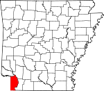
Miller County, Arkansas Basics:


Miller County Arkansas - Government Site

Population: 43,620
Area: 626 square miles
County seat: Texarkana
Area code(s) in use: 870
Time zone: CST
High school graduate or higher: 84.0%
Bachelor's degree or higher: 12.9%
Median household income: $40,314
Persons in poverty: 20.1%
Home ownership rate: 66.2%
Mean travel time to work: 20.2 minutes


Adjacent counties:
Bossier (LA)  Bowie (TX)  Caddo (LA)  Cass (TX)  Hempstead  Lafayette  Little River  

Find in Arkansas

Map of the Miller County area


Our detail map of Miller County shows the Miller County, Arkansas boundary lines and other interesting items.

Places in Miller County, Arkansas

  Airports     show all on map

Bill Rogers Airport, Flying W Airport, Macks Airport, Reed-Joseph Land Company Airport, Saint Michael Hospital Heliport, Texarkana Regional Airport-Webb Field

  Bends     show all on map

Brown Bend, Dickson Bend, Dillard Bend

  Bridges     show all on map

Beloh Bridge, Red River Bridge

  Buildings     show all on map

Boggy Creek Volunteer Fire Department, Booker Bridge Fire Department, Bright Star Volunteer Fire Department, Doddridge Volunteer Fire Department, Federal Bureau of Investigation Office, Federal Bureau of Investigation Texarkana Resident Office, Fouke City Fire Department, Fouke Police Department, Garland City Fire Department, Genoa Volunteer Fire Department, Immigration Customs Enforcement, Lifenet Air Ambulance, Mandeville Volunteer Fire Department, Miller County Courthouse, Miller County Sheriff's Office, North Heights Neighborhood Center, Pleasant Hill Fire Department, Satellite Fire Department, Texarkana Arkansas Fire Department Station 1, Texarkana Arkansas Fire Department Station 2, Texarkana Arkansas Fire Department Station 3, Texarkana Arkansas Fire Department Station 4, Texarkana Arkansas Fire Department Station 5, Texarkana City Hall, Texarkana Housing Authority, Texarkana Narcotics Drug Task Force, Texarkana Regional Airport Rescue and Fire Department, Trinity Volunteer Fire Department, Vista Health Texarkana

  Canals     show all on map

Gillespie Ditch, Homan Ditch

  Cemeteries     show all on map

Blanton Cemetery, Brown Cemetery, Calvary Cemetery, Cleveland Cemetery, Fair Haven Cemetery, Fouke Cemetery, Gibson Cemetery, Harrison Chapel Cemetery, McKenzie Cemetery, Mount Oba Cemetery, New Hope Cemetery, Paup Cemetery, Phylaw Cemetery, Polk Cemetery, Rock Springs Cemetery, Rocky Mound Cemetery, Rondo Cemetery, State Line Cemetery, Sulphur Fork Cemetery, Walters Cemetery, Woodlawn Cemetery

  Churches     show all on map

Antioch Church, Apostolic Tabernacle, Beech Street First Baptist Church, Bethel Baptist Church, Boyd Church, Calvary Baptist Church, Canaan Baptist Church, Canaan Land Church, Caney Church, Cedar Grove Church, Central Church, College Hill Missionary Baptist Church, College Hill United Methodist Church, Concord Church, Corinth Church, County Avenue Baptist Church, Doddridge Church, Elem Church, Enon Church, Evergreen Church, Fairland Church, Fairview United Methodist Church, Few Memorial United Methodist Church, First Church of Christ Scientist, First Church of the Nazarene, First Congregational Methodist Church, First Presbyterian Church, First United Methodist Church, Genoa Baptist Church, Haley Church, Harmony Grove Church, Harrison Chapel, Hickory Street Baptist Church, Holly Springs Church, Independence Church, Iron Mountain Tabernacle, Lane Fort Church, Little Church, Lonoke Baptist Church, Macedonia Church, Macedonia Church, Macedonia Church, Mount Olive Church, Mount Pleasant Church, New Hope Church, New Saint Paul Church, Oak Grove Church, Old Saint Paul Church, Pleasant Hill Church, Pleasant Valley Church, Promised Land Church, Rocky Mound Church, Saint Edwards Catholic Church, Saint James Baptist Church, Saint Johns Church, Salem Church, Salem Church, Sand Hill Church, Shiloh Church, Springhill Church, Sylverino Church, Tennessee Baptist Church, Tregg Church, Troy Church, West Tract Church

  Cliffs     show all on map

Buzzard Bluff

  Crossings     show all on map

Interchange 1, Interchange 12, Interchange 2, Interchange 7, Line Ferry (historical)

  Dams     show all on map

Alex Smith Lake Dam, Arkla Lake Dam, Boyce Lake Dam, Buford Lake Dam, Coca Cola Lake Dam, Country Club Lake Dam, Cox Lake Dam, Crabtree Lake Dam, Davis Lake Dam, Davis Lake Dam Number Two, Eason Lake Dam, Gill Lake Dam, Hensley Lake Dam, Long Slough Dam, Mitchell Lake Dam, Old Bitty Lake Dam, Paradise Lake Dam, R Jones Lake Dam, Robinson Estate Lower Lake Dam, Robinson Estate Upper Lake Dam, Robinson Lake Dam, Smith Lake Dam, State Line Lake Dam, Upper Moore Lake Dam, Westmoreland Lake Dam, Williams Lake Dam, Wooten Lake Dam

  Flats     show all on map

Hunters Island

  Guts     show all on map

Mercer Bayou

  Hospitals     show all on map

Saint Louis Southwestern Railway Hospital, Saint Michael Hospital of Texarkana

  Islands     show all on map

Ford Islands

  Lakes     show all on map

Adams Cut-off Lake, Alligator Lake, Candler Lake, Clark Lake, Clear Lake, Cypress City Lake, Cypress Lake, Elliott Slough, Fish Lake, Ford Slough, Goose Lake, Haley Lake, Harper Lake, Keller Lake, Kennedy Lake, Kuykendall Lake, Little Pond, Long Slough, Mathis Slough, Mercer Lake, Moes Slough, Palmer Lake, Pinhook Lake, Red Lake, Scott Lake, Second Old River Lake, Snaggy Lake, Snake Lake, Tobe Lake, Whites Camp Lake, Willow Lake, Winham Lake

  Locales     show all on map

Airport Industiral Park, Camp Hunt, Four States Fair Grounds, South Haven Golf Course, Texarkana Country Club, Valley Gin

  Military     show all on map

Texarkana Air Force Station (historical)

  Mines     show all on map

Gifford Hill Gravel Pit

  Oilfields     show all on map

Cypress Lake Oil and Gas Field, Fouke Oil Field, Garland City Oil and Gas Field, Millett Oil and Gas Field, Rodessa Oil and Gas Field

  Parks     show all on map

Bradfield Park, Bramble Park, Buhrman Field, George Williams Park, Hobo Jungle Park, Hole-In-The-Wall Park, Ingraham Park, Jefferson Park, Kline Park, North Texarkana Park, Razorback Stadium, Sulphur River State Wildlife Management Area

  Populated Places     show all on map

Artex, Beck, Black Diamond, Boggy, Boggy (historical), Boyd, Brightstar, Capps City, Clear Lake Junction, Clipper, Doddridge, Dooley, Era (historical), Fairland, Ferguson Crossroads, Fort Lynn, Fouke, Garland, Genoa, Gertrude, Hammons, Hervey, Homan, Index, Jonesville, Kiblah, Lakewood Estates, Mandeville, Mayton, McKinney, Mount Pleasant, Paup, Pleasant Hill, Ravanna, Roberts (historical), Rocky Mound, Rondo, Smithville, Spring Bank (historical), Sylverino, Texarkana, Wona (historical)

  Post Offices     show all on map

Cameron Post Office (historical), Genoa Post Office, Texarkana Post Office, Wona Post Office (historical)

  Reservoirs     show all on map

Arkla Lake, Boyce Lake, Browns Lake, Buford Lake, Coca Cola Lake, Country Club Lake, Cox Lake, Crabtree Lake, Davis Lake, Davis Lake Number Two, Eason Lake, Gill Lake, Hensley Lake, Jones Lake, Lower Lake, Lower Moore Lake, Mitchell Lake, Old Bitty Lake, Paradise Lake, Robinson Lake, Smith Lake, Smith Lake, State Line Lake, Upper Lake, Upper Moore Lake, Wadley Lake, Westmoreland Lake, Williams Lake, Wooten Lake

  Ridges     show all on map

Gum Ridge

  Schools     show all on map

Arkansas High School, Booker T Washington High School, Bright Star Elementary School, Bright Star High School (historical), Carver School, Central School, College Hill Elementary School, College Hill Junior High School, College Hill Middle School, Daniels School, Edward D Trice Elementary School, Edward P Trice Elementary School, Fairview Elementary School, Fouke Elementary School, Fouke High School, Fouke Middle School, Garland Elementary School, Garland High School, Gary E Cobb Middle School, Genoa Central Elementary School, Genoa Central High School, Kiblah School (historical), North Heights Junior High School, North Heights School, Orr School, Saint Edwards School, Union Elementary School, Vera Kilpatrick Elementary School

  Springs     show all on map

Holly Springs

  Streams     show all on map

Adams Creek, Beech Creek, Boggy Creek, Bois d'Arc Bayou, Caney Branch, Caney Creek, Capps Branch, Cedar Creek, Chicken Creek, Coe Creek, Comer Branch, Cypress Slough, Day Branch, Days Creek, Dry Creek, East Fork Kelly Bayou, Finn Bayou, Forky Deer Creek, Fourmile Creek, Hicks Branch, Holly Springs Branch, Hooker Branch, Lick Branch, May Branch, McKinney Bayou, Mill Creek, Mill Creek, Moccasin Bayou, Morgan Branch, Nix Creek, Old Channel McKinney Bayou, Pill Branch, Prairie Creek, Red Chute, Rocky Creek, Spring Branch, Sulphur River, Tennessee Branch, Turkey Creek, Turkey Creek, West Fork Kelly Bayou

  Summits     show all on map

Krause Hill, The Mounds, Wilburn Hill, Wolf Mountain

  Swamps     show all on map

Bee Lake, Bluff Lake, Bradley Lake, Oak Lake, Silver Lake

  Towers     show all on map

KKYR-AM (Texarkana), KUKB-FM (Texarkana), Sulphur River Lookout Tower,

Miller County, Arkansas Population By Race (2012 estimate)

RacePopulation
WhiteMiller County White population 31,62531,624  
BlackMiller County Black population 10,68710,686
MixedMiller County Mixed population 698697
American IndianMiller County American Indian population 349348
AsianMiller County Asian population 218218
Hawaiian & Pacific IslanderMiller County Hawaiian & Pacific Islander population 4443

Additional population tables :
State population table
Arkansas population by county