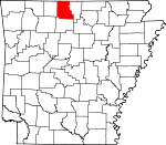
Marion County, Arkansas Basics:
Marion County Arkansas - Government Site
Population: 16,599
Area: 597 square miles
County seat: Yellville
Area code(s) in use: 870
Time zone: CST
High school graduate or higher: 83.8%
Bachelor's degree or higher: 13.2%
Median household income: $33,497
Persons in poverty: 18.2%
Home ownership rate: 81.5%
Mean travel time to work: 22.5 minutes
Adjacent counties:
Baxter Boone Ozark (MO) Searcy Taney (MO)
Places in Marion County, Arkansas
Burns Funeral Home Parking Lot Heliport,
Marion County Regional Airport,
Pine Mountain Airpark,
Thunder Ridge Ranch Airport,
Totty Field Airport Indian Rockhouse,
Ralph Natural Bridge Campbells Shoal,
Clabber Creek Shoal,
Cow Rock Shoals,
Fishtrap Shoal,
Fox Bar Shoal,
Greasy Shoal,
Leatherwood Shoal,
Roaring Rock,
Silver Hollow Shoal,
Tinnan Rock Shoals Barnes Bay,
Cow Cove,
Five Finger Cove,
Gin Eddy,
Moon Cove,
Three Finger Cove Horseshoe Bend,
Hudsons Bend Bruno Volunteer Fire Protection District,
Bull Shoals Police Department,
Bull Shoals Volunteer Fire Department Station,
Fairview Rural Volunteer Fire Department,
Flippin Fire Department,
Flippin Police Department,
Lakeway Rural Volunteer Fire Station 1,
Lakeway Rural Volunteer Fire Substation 2,
Lakeway Volunteer Fire Department Substation,
Lazy Acres Fire Department,
Lazy Acres Fire Protection District Station 2,
Lazy Acres Fire Protection District Station 3,
Lazy Acres Volunteer Fire Department Station 1,
Marion County Courthouse,
Marion County Sheriff's Office,
Oakland - Promise Land Volunteer Fire Department Station 1,
Oakland - Promise Land Volunteer Fire Department Station 2,
Peel Volunteer Fire Department,
Peel Volunteer Fire Department Substation,
Pine Mountain Volunteer Fire Department,
Pine Mountain Volunteer Fire Department Substation,
Pyatt Rural Fire and Defense Association,
Pyatt Rural Volunteer Fire Department Substation,
Ralph - Caney Rural Fire Protection,
Ralph - Caney Rural Fire Protection Unit,
Rea Valley Volunteer Fire Department,
Rea Valley Volunteer Fire Department Station 2,
Summit Station 2,
Summitt Volunteer Fire Department,
Yellville Volunteer Fire Department Frost Point Adams Cemetery,
Anderson Flat Cemetery,
Beckham Cemetery,
Bruno Cemetery,
Burch Cemetery,
Burns Cemetery,
Caney Cemetery, Cedar Creek Cemetery,
Cowan Cemetery,
Derryberry Cemetery,
DeSoto Cemetery,
Dodd City Cemetery,
Elm Springs Cemetery,
Fairview Cemetery,
Flippin Cemetery,
Georges Creek Cemetery,
Hall Cemetery,
Hand Valley Cemetery,
Hurst Cemetery,
Jaybird Cemetery,
Jenkins Cemetery,
Keesee Cemetery,
Lee Mountain Cemetery,
Locust Cemetery,
Moccasin Cemetery,
Mountain View Cemetery,
Nanny Cemetery,
Newton Flat Cemetery, Old Buffalo Cemetery,
Ott Cemetery, Page Cemetery,
Patton Cemetery,
Peel Cemetery,
Pickard Cemetery,
Pleasant Ridge Cemetery,
Price Place Cemetery,
Promised Land Cemetery,
Riddle Cemetery,
Stanley Cemetery,
Upshaw Cemetery,
Wickersham Cemetery,
Williams Cemetery,
Wood Cemetery,
Yellville Cemetery Blind Chute,
Dog Leg Chute,
Petits Chute,
Rose Berry Chute,
Shields Chute Anderson Flat Church,
Antioch Number 1 Baptist Church,
Beckham Church,
Brown Church,
Bruno Baptist Church,
Caney Church of Christ,
Christ by the Lake Lutheran Church,
Fairview Church of Christ,
Hilltop Mission,
Keesee Church,
Locust Church,
Mull Church of Christ,
New Hope Baptist Church,
Peel Missionary Baptist Church,
Pleasant Ridge Methodist Church,
Price Church,
Promise Land Church,
Pyatt Baptist Church,
Pyatt Church of Christ,
Rea Valley Baptist Church,
Summit Baptist Church, Wares Chapel Methodist Church (historical),
Welcome Ridge Church Bull Bottom Bluff,
Buzzard Bluff,
Cane Bottom Bluff,
Crystal Point,
Poison Point,
Stair Bluff,
Tie Chute Bluff,
Wilson Bluff Birds Ford,
Boonie Ford,
Brantley Ford,
Buck Shoals Ford (historical),
Dews Ford,
Fishtrap Shoals Ford (historical),
Foster Ford,
Goodmans Ford, Hawkins Ferry (historical),
Holt Ferry (historical),
Keesee Ferry (historical),
McBees Ferry (historical),
Pace Ferry (historical),
Rocky Ford,
Shields Ford,
Spencer Ford,
Warners Ford,
Weast Ford,
Woodcocks Ford,
Wooten Ford Bull Shoals Dam Lay Falls Anderson Flat,
Ham Flat,
Kings Prairie,
Pine Flat Bucker Gap,
Huffman Gap Bull Shoals Community Hospital and Clinic,
Marion County Hospital (historical) Cane Island,
Ozark Isle Waltman Pond Buffalo Landing,
Bull Shoals Shopping Center,
McBee Landing,
Wares Chapel,
Woodcocks Mill (historical) Bear Hill Mine,
Copperhead Mine,
Erie Ozark Mine,
Lead Drift Mine,
Lost Bell Mine,
Markle Mine,
Monkey Hill Mine,
Onwata Mine,
Pigeon Roost Mine,
Pilot Rock Mine Buck Creek Public Use Area,
Buffalo River State Park,
Bull Shoals Natural Park,
Bull Shoals Public Use Area,
Highway 125 Public Use Area,
Jones Point Wildlife Management Area,
Oakland Public Use Area,
Ozard Isle Public Use Area,
Ozark Isle Public Use Area,
Point Return Public Use Area,
Rush Historic District Standing Rock,
The Rock House Big Springs (historical),
Bruno,
Bull Shoals,
Caney,
Comal,
Cowan,
Dodd City,
Eros,
Fairview,
Flippin,
Freck,
Georges Creek,
Hand Valley,
Hepsey (historical),
Keystone (historical),
Kingdom Springs (historical),
Lakeway,
Midway,
Monarch,
Mount Perrian (historical),
Mull,
Oakland,
Old Buffalo,
Peel,
Pine Branch,
Powell,
Price Place,
Pyatt,
Ralph,
Rea Valley,
Rush,
Snow,
Stone (historical),
Summit,
Sylvia (historical),
Turkey,
Verona,
Yellville Adams Post Office (historical), Ball Post Office (historical), Bend Post Office (historical), Bendona Post Office (historical), Brodie Post Office (historical),
Bruno Post Office, Bull Shoals Post Office, Calffern Post Office (historical), Cowan Post Office (historical), Dodd City Post Office (historical), Dubuque Post Office (historical), Dugger Post Office (historical), Eros Post Office (historical), Exter Post Office (historical), Fears Post Office (historical), Flippin Post Office, Freck Post Office (historical), Georges Creek Post Office (historical), Helva Post Office (historical), Hepsey Post Office (historical), Jacfontan Post Office (historical), Johnson Post Office (historical), Keystone Post Office (historical), Kingdom Springs Post Office (historical), Lionhill Post Office (historical), Maryhattiana Post Office (historical), McBee Landing Post Office (historical), Monarch Post Office (historical), Mount Perrian Post Office (historical), Mull Post Office (historical), Noes Ferry Post Office (historical), Oakland Post Office (historical), Onset Post Office (historical), Onwata Post Office (historical),
Peel Post Office, Powell Post Office, Pyatt Post Office, Pyleville Post Office (historical), Ralph Post Office (historical), Rosslow Post Office (historical), Rush Post Office (historical), Sherman Post Office (historical), Silver Run Post Office (historical), Stewarts Town Post Office (historical), Stone Post Office (historical), Sugarloaf Mills Post Office (historical), Summit Post Office, Sylva Post Office (historical), Teagarden Post Office (historical), Turkey Post Office (historical), Verona Post Office (historical), Water Creek Post Office (historical), Yellville Post Office
Buffalo National River (Lower Buffalo Unit) Wilderness Bull Shoals Lake Campbell Ridge,
Gay Ridge,
Hoodlum Ridge,
Linley Ridge,
Linton Ridge,
Rose Ridge,
Sharpy Jim Ridge,
Spencer Ridge,
Sunset Ridge,
Wilkerson Ridge,
Windgate Ridge,
Wolf Wallow Ridge Anderson Flat School (historical), Arkansas School (historical), Bearden School (historical), Black School (historical), Bluff Springs Academy (historical), Bonanza School (historical),
Bruno School (historical),
Bruno-Pyatt Elementary School,
Bruno-Pyatt High School, Buffalo School (historical), Cantrell School (historical), Cave Bottom School (historical), Cedar Creek School (historical), Cedar Glade School (historical), Cedar Grove School (historical), Chigger Hill School (historical), Concord School (historical), Cowan School (historical), Crooked Creek Male Academy (historical), Dillard School (historical),
Dodd City School (historical), Elm Springs School (historical), Enon School (historical),
Eros School (historical),
Fairview School (historical),
Flippin Elementary School,
Flippin High School,
Flippin Middle School, Freck School (historical), Georges Creek School (historical), Good Hope School (historical),
Hamlet School (historical), Hand Valley School (historical), Hepsey School (historical), Hide Out School (historical), Hilltop School (historical),
Jefferson Hall School (historical), Jones School (historical),
Keesee School (historical),
Kingdom Springs School (historical), Locust School (historical), Longtime School (historical), Markle School (historical), Midway School (historical), Mountain View School (historical),
Mull School (historical), New Hope School (historical), Newton Flat School (historical), Number One School (historical), Oak Grove School (historical),
Oakland School, Old Powell School (historical),
Peel School (historical), Pleasant Grove School (historical), Possum Trot School (historical), Powell School (historical),
Price Place School (historical), Promise Land School (historical),
Pyatt School (historical),
Rea Valley School (historical),
Rocky Hollow School (historical),
Rush School (historical), Snow School (historical), Sugar Orchard School (historical), Turnbo School (historical), Watts School (historical), Wildcat School (historical), Yellville College (historical), Yellville Male and Female Seminary (historical),
Yellville-Summit Elementary School,
Yellville-summit Elementary School,
Yellville-Summit High School,
Yellville-Summit Middle School, Yocham Bend School (historical), Yocham School (historical)
Chapman Spring,
Coon Spring,
Ebbing Springs,
Elephant Spring,
Fox Den Spring,
Glenn Spring,
Gray Spring,
Grever Spring,
Marble Falls Spring,
Markle Spring,
Morris Spring,
Ozark Mountain Spring,
Sailor Spring,
Sycamore Spring Barren Fork,
Big Creek,
Big Music Creek,
Blue John Creek,
Boat Creek,
Boren Fork,
Brush Creek,
Brush Creek,
Brushy Fork,
Buffalo River,
Burns Creek,
Cabin Creek,
Campground Creek,
Caney Branch,
Cedar Creek,
Cedar Creek,
Cedar Creek,
Clabber Creek,
Clear Creek,
Coon Creek,
Cow Creek,
Crane Creek,
Crooked Creek,
Dean Branch,
Dry Music Creek,
Dry Run (historical),
East Fork Hampton Creek,
East Prong Town Branch,
Fallen Ash Creek,
Fishtrap Creek,
Flat Hollow Branch,
Georges Creek,
Gosha Creek,
Greasy Creek,
Gulley Spring Creek,
Gunnel Fork,
Hampton Branch,
Hampton Creek,
Hogskin Creek,
Hollingsworth Cove,
Horton Creek,
Hurricane Creek,
Ingram Creek,
Ingram Creek,
Jenkins Branch,
Jimmie Creek,
Johnnie Creek,
Kings Branch,
Laffoon Creek,
Lay Creek,
Lead Mine Creek,
Little Buck Creek,
Little Cedar Creek,
Little Fool Creek,
Little Georges Creek,
Little Music Creek,
Little North Fork White River,
Little Panther Creek,
Little Rush Creek,
Little Sugar Creek,
Locust Creek,
Middle Creek,
Mill Creek,
Mitchell Creek,
Moccasin Creek,
Mountain Creek,
Neilon Creek,
Noe Creek,
North Fork Tomahawk Creek,
Panther Creek,
Pigeon Roost Branch,
Pine Branch,
Pine Hollow Creek,
Pot Shoals Creek,
Running Fork,
Rush Creek,
Shakerag Creek,
Sheep Jump Creek,
Short Creek,
Sister Creek,
Sister Creek,
Slick Rock Creek,
Spicewood Creek,
Spring Creek,
Strawberry Creek,
Sugar Orchard Creek,
Tar Kiln Branch,
Tar Kiln Creek,
Town Branch,
Trimble Creek,
Valley Branch,
Warner Creek,
Warrior Creek,
Wildcat Creek,
Williams Branch,
Williams Creek,
Wolf Creek,
Wolfpen Branch,
Yocum Cove Bald Jesse,
Bull Shoals Mountain,
Clark Hill,
Cleveland Knob,
Goard Point,
Granite Mountain,
Hall Mountain,
Hand Mountain,
Hathaway Mountain,
Japanese Knob,
Lee Mountain,
Lion Hill,
Long Mountain,
Pine Mountain,
Prince Fred Knob,
Round Mountain,
Short Mountain,
Tater Knob,
Turkey Mountain,
Warrior Creek Mountain Freck Lookout Tower,
KCTT-AM (Yellville),
KCTT-FM (Yellville),
Tar Kiln Lookout Tower Angel Springs Hollow,
Ball Hollow,
Barney Hollow,
Beach Hollow,
Bear Hill Hollow,
Bear Hollow,
Bear Hollow,
Becky Hollow,
Black Bear Hollow,
Booker Hollow,
Boozer Hollow,
Buck Spring Hollow,
Bull Hollow,
Campbell Hollow,
Caney Hollow,
Caney Hollow,
Carver Hollow,
Cave Hollow,
Cave Hollow,
Cedar Hollow,
Chapman Hollow,
Clyde Hollow,
Coal Pit Hollow,
Cold Spring Hollow,
Cold Spring Hollow,
Coldwater Hollow,
Cook Hollow,
Cove Hollow,
Dark Hollow,
Dark Hollow,
Davis Hollow,
Dilday Hollow,
Elbow Hollow,
Elbow Hollow,
Elm Cave Hollow,
Elm Hollow,
Fee Hollow,
Fishtrap Hollow,
Flat Hollow,
Fox Hollow,
George Treat Hollow,
Grapevine Hollow,
Gravelly Hollow,
Green Campbell Hollow,
Gulf Hollow,
Harris Hollow,
Hathaway Hollow,
Hawkins Hollow,
Hogskin Hollow,
Horse Hollow,
Iola Hollow,
Jim Hollow,
John Treat Hollow,
Jones Hollow,
Keystone Hollow,
Leader Hollow,
Lean Mine Hollow,
Leon Hollow,
Little Beach Hollow,
London Spring Hollow,
Lonely Hollow,
Loonbeam Hollow,
Markle Hollow,
Martin Hollow,
Mill Hollow,
Mining House Hollow,
Moore Hollow,
Nokomis Hollow,
North Star Hollow,
Oak Hollow,
Onwata Hollow,
Open Hollow,
Pannell Hollow,
Panther Hollow,
Parker Hollow,
Parks Hollow,
Peter Hollow,
Pig Pen Hollow,
Pine Hollow,
Pine Hollow,
Pine Hollow,
Pine Hollow,
Pine Hollow,
Pine Hollow,
Pine Hollow,
Plum Hollow,
Rough Hollow,
Salina Hollow,
Sand Spring Hollow,
Seed Tick Hollow,
Shop Hollow,
Silver Hollow,
Stallion Hollow,
Stave Mill Hollow,
Sunrise Hollow,
Tallow Clay Hollow,
Tom Hollow,
Turnbull Hollow,
Upshaw Hollow,
Walker Hollow,
White Oak Hollow,
Willow Spring Hollow,
Wilson Hollow,
Wilson Hollow,

