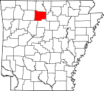
Searcy County, Arkansas Basics:


Searcy County Arkansas - Government Site

Population: 8,026
Area: 666 square miles
County seat: Marshall
Area code(s) in use: 870
Time zone: CST
High school graduate or higher: 74.4%
Bachelor's degree or higher: 11.0%
Median household income: $30,301
Persons in poverty: 25.0%
Home ownership rate: 74.9%
Mean travel time to work: 27.4 minutes


Adjacent counties:
Baxter  Boone  Marion  Newton  Pope  Stone  Van Buren  

Find in Arkansas

Map of the Searcy County area


Our detail map of Searcy County shows the Searcy County, Arkansas boundary lines and other interesting items.

Places in Searcy County, Arkansas

  Airports     show all on map

Searcy County Airport

  Areas     show all on map

The Wilderness

  Basins     show all on map

The Basin

  Benches     show all on map

Big Bench, Horn Bench

  Bends     show all on map

Arnold Bend, Cash Bend, Cedar Bend, Crane Bottom, Lane Bend, Patterson Bottom, Tyler Bend

  Buildings     show all on map

Chimes - Shady Grove Volunteer Fire Department Substation, Harriet - Rock Creek Cosey Home Fire Station, Landis Fire Station, Leslie Fire Department, Marshall Fire Department, Marshall Police Department, Morning Star Fire Department, Northern Arkansas Regional Medical Center Emergency Medical Service - Searcy County, Oxley Volunteer Fire Department, Pindall Gilbert and Saint Joe Volunteer Fire Department, Searcy County Courthouse, Searcy County Sheriff's Office, Snowball Fire Station, South Mountain Fire Department, Southern Paramedic Service - Marshall, Welcome Home Fire Department, Witts Springs Volunteer Fire Department

  Capes     show all on map

Buck Point, Russell Point

  Cemeteries     show all on map

Arnold Cemetery, Baldwin Hill Cemetery, Bear Creek Cemetery, Caid Cemetery, Canaan Cemetery, Cash Cemetery, Chinquapin Cemetery, Crider Cemetery, Cypert Cemetery, DePriest Cemetery, East Lawn Cemetery, Elberta Cemetery, Glencoe Cemetery, Hall Cemetery, Hendrix Cemetery, Henley Cemetery, Hensley Cemetery, Horn Cemetery, Horton Cemetery, Kilburn Cemetery, Kuykendall Cemetery, Landis Cemetery, Leslie Cemetery, Mabrey Cemetery, McDaniel Cemetery, Nichols Cemetery, Oak Hill Cemetery, Parks Cemetery, Parks Cemetery, Passmore Cemetery, Red Hill Cemetery, Rock Creek Cemetery, Sanders Cemetery, Scribner Cemetery, Shady Grove Cemetery, Shiloh Cemetery, Silver Hill Cemetery, Slay Cemetery, Sulphur Springs Cemetery, Thompson Cemetery, Tomahawk Cemetery, Trammell Cemetery, Treat Cemetery, Watts Cemetery, Whisenant Cemetery, Wilson Cemetery

  Churches     show all on map

Assembly of God Church, Barren Hollow Church, Bear Creek Church, Bethlehem Church, Canaan Church, Church of Christ, Church of Christ, Garrett Memorial Church, Grand View Church, Hilltop Chapel, Martin Box Chapel, Morning Star Baptist Church, New Hopewell Church, Oak Hill Church, Pilot Mountain Church, Pine Bluff Church, Pine Bluff Church, Pine Grove Church, Pleasant Church, Pleasant Hill Church, Rambo Church, Red Hill Church, Shady Grove Church, Shiloh Church, Snowball Baptist Church, South Mountain Church, Tomahawk Baptist Church, Trace Ridge Church, Union Church

  Cliffs     show all on map

Cane Bluff, Doins Point, Gower Point, Henderson Point, John Reddell Bluff, Nolan Point, Point Peter, Red Bluff, Rollins Point, Salt Cave Bluff, White Bluff

  Crossings     show all on map

Bend Ford, Hensley Ford, Maumee Crossing, Roughedge Ford, White Ford

  Dams     show all on map

Baker Lake Dam, Lake Ferguson Dam

  Flats     show all on map

Deitrich Flat, Pumpkin Flat

  Gaps     show all on map

McCutchen Gap, The Narrows

  Locales     show all on map

Ashley Mill (historical), Kenda Drive-In, Peter Cave, Richland Recreation Area

  Mines     show all on map

Excelsor Mine, Hurricane Mine

  Parks     show all on map

Buffalo National River, Richland Recreation Area, Stack Rock Scenic Area

  Populated Places     show all on map

Baker, Baker Hollow, Barren Hollow, Bear Creek, Begley (historical), Blanco, Bohannon, Booster, Buroak, Campbell, Canaan, Clutes (historical), Cozahome, Dongola, Dry Creek (historical), Duff, Dugger (historical), Elberta, Eula, Evening Star, Fairview, Gilbert, Hall (historical), Harriet, Horn Mountain (historical), Imo, Jameson (historical), Kay, Landis, Lebanon (historical), Leigo (historical), Leslie, Lone Pine, Magic Springs, Marsena, Marshall, Martin Box, Maumee, Morning Star, Noahs, Oxley, Pindall, Point Peter, Push, Rock Springs, Rumley, Saint Joe, Shilo (historical), Silver Hill, Slicker (historical), Snowball, Thola, Tomahawk, Watts, Welcome Home, Wileys Cove, Witts Springs, Woolum, Zack, Zeb (historical)

  Post Offices     show all on map

Blanco Post Office (historical), Campbell Post Office (historical), Cozahome Post Office, Harriet Post Office, Oxley Post Office (historical), Saint Joe Post Office, Snowball Post Office (historical), Zack Post Office (historical)

  Ranges     show all on map

Cane Branch Hills

  Reservoirs     show all on map

Baker Lake, Lake Ferguson

  Ridges     show all on map

Bradley Ridge, Chinquapin Spring Ridge, Devils Backbone, Giles Turney Ridge, Trace Ridge

  Schools     show all on map

Blanco School, Bohannon School, Brown School, Buroak School, Cane Branch School, Cooper School, Dry Creek School, Grassay Gap School, Hall School, Happy Hollow School, Horn Mountain School, Leslie Elementary School, Leslie High School, Manes Town School, Marshall Elementary School, Marshall High School, Saint Joe Elementary School, Saint Joe High School, Shady Grove School, Slicker School, Wasson School, Welcome Home School, Witts Springs Elementary School, Witts Springs High School

  Springs     show all on map

Cave Spring, Chinquapin Spring, Dugger Spring, Glencoe Spring, Leadbetter Spring, Schoolhouse Spring, Scott Spring

  Streams     show all on map

Bailey Cole Creek, Baker Spring Branch, Ballinger Branch, Bear Creek, Bear Creek, Beaver Creek, Bee Branch, Begley Creek, Ben Branch, Bobtail Creek, Bratton Creek, Brush Creek, Calf Creek, Cane Branch, Cellar Creek, Coatner Spring Branch, Cove Creek, Crooked Branch, Cub Creek, Davis Creek, Dean Branch, Dry Branch, Dry Branch, Dry Creek, Dry Creek, Dry Prong Spring Creek, Dugget Creek, East Fork Clear Creek, Falling Water Creek, Forest Creek, Gourd Creek, Granny Creek, Hickory Creek, Holder Creek, Hurricane Creek, Jamison Creek, Jerry Branch, Kelley Creek, Kimball Branch, Kimball Creek, Kimbrell Creek, Lick Fork Creek, Little Bobtail Creek, Little Creek, Little Red Creek, Little Rocky Creek, Long Creek, Mill Branch, Mill Creek, Mill Creek, North Cedar Creek, Piney Branch, Richland Creek, Rock Creek, Rocky Creek, Schoolhouse Branch, Short Creek, South Bratton Creek, South Prong Middle Creek, Spider Creek, Spring Creek, Sulphur Creek, Sulphur Spring Branch, Tom Moss Branch, Tomahawk Creek, Trace Creek, Truck Wheel Branch, Turkey Creek, Turkey Pen Creek, Water Creek, West Fork Bear Creek, West Fork Clear Creek, Wilson Creek

  Summits     show all on map

Almus Knob, Bald Knob, Baldwin Hill, Barr Mountain, Bear Mountain, Ben Hill, Big Point, Blackjack Knob, Blue Mountain, Bohannon Mountain, Brushy Mountain, Brushy Point, Bryan Mountain, Buzzard Roost Mountain, Chicken Wilson Knob, Davy Crockett Mountain, Dean Mountain, Dean Point, Gobblers Knob, Granny Mountain, Green Griffin Knob, Henderson Knob, Horn Mountain, Housley Mountain, Jamison Hill, Lick Owens Mountain, McCutchen Hill, Nolan Knob, Pate Mountain, Pilot Mountain, Pine Knob, Pipkins Point, Pleasant Hill, Point Peter Mountain, Reves Knob, Robertson Hill, Robertson Hill, Rollins Point, Round Hill, Round Mountain, Saint Joe Mountain, South Mountain, Stack Rock, Star Mountain, Stephenson Mountain, Suggs Mountain, Tater Hill, Thompson Point

  Towers     show all on map

KCGS-AM (Marshall), KSNE-FM (Marshall)

  Valleys     show all on map

Armstrong Hollow, Avery Hollow, Baker Hollow, Barnes Hollow, Barren Hollow, Bearcat Hollow, Bearcat Hollow, Beck Hollow, Big Hollow, Big Hollow, Big Hollow, Blacksnake Hollow, Blanco Hollow, Boone Hollow, Bowers Field Hollow, Bradley Hollow, Branch Hollow, Brown Hollow, Browning Hollow, Bryan Hollow, Bull Hollow, Bunkhouse Hollow, Burlston Hollow, Butler Hollow, Byrd Hollow, Cambell Hollow, Cap Berry Hollow, Carl and Dowdell Hollow, Cartwright Hollow, Cave Spring Hollow, Cedar Hollow, Cedar Hollow, Cedar Hollow, Coon Hollow, Copper Mine Hollow, Cotton Hollow, Cotton Hollow, Crane Hollow, Cross Hollow, Curtis Hollow, Cyner Hollow, Dipping Vat Hollow, Drury Hollow, Eadl Hollow, Elm Hollow, Elm Hollow, Elmer Hollow, Ezell Hollow, Flat Hollow, Flat Hollow, Gibbins Hollow, Gin Hollow, Gold Mine Hollow, Goodhue Hollow, Granny Price Hollow, Grassy Hollow, Gray Hollow, Gray Hollow, Green Haw Hollow, Griffin Hollow, Hage Hollow, Happy Hollow, Harris Hollow, Hensley Hollow, Hickory Hollow, Hog Hollow, Hollabaugh Hollow, Holstead Hollow, Jenny Harness Hollow, Johnson Hollow, King Hollow, Lick Hollow, Marshall Hollow, Maumee Hollow, McKinney Hollow, Mears Hollow, Mill Hollow, Miller Hollow, Mitchell Hollow, Mud Hollow, Nolan Hollow, Osborne Hollow, Pea Vine Hollow, Picayune Hollow, Possum Hollow, Puss Hollow, Rattlesnake Hollow, Rattlesnake Hollow, Rattlesnake Hollow, Reed Hollow, Rocky Hollow, Rocky Hollow, Rocky Hollow, Roughedge Hollow, Sawmill Hollow, Scott Hollow, Scott Hollow, Scott Hollow, Shiloh Hollow, Short Bobtail Hollow, Sinyard Hollow, Smith Hollow, Spring Branch Hollow, Sulphur Springs Hollow, Sweet Gum Hollow, Tucker Hollow, Turnpike Hollow, Vickery Hollow, Warner Hollow, Wassen Hollow, Watts Hollow, Watts Hollow, West Spring Hollow, Whaley Hollow, Wheeler Hollow, Whisenant Hollow, White Hollow, Wildcat Hollow, Wildcat Hollow, Williams Hollow, Winding Star Hollow, Woods Hollow, Wooten Hollow, Young Hollow,

Searcy County, Arkansas Population By Race (2012 estimate)

RacePopulation
WhiteSearcy County White population 7,6977,696  
MixedSearcy County Mixed population 177176
American IndianSearcy County American Indian population 112112
BlackSearcy County Black population 2424
AsianSearcy County Asian population 1616
Hawaiian & Pacific IslanderSearcy County Hawaiian & Pacific Islander population 00

Additional population tables :
State population table
Arkansas population by county