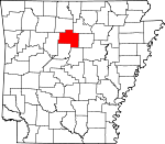
Van Buren County, Arkansas Basics:


Van Buren County Arkansas - Government Site

Population: 17,074
Area: 708 square miles
County seat: Clinton
Area code(s) in use: 501
Time zone: CST
High school graduate or higher: 82.0%
Bachelor's degree or higher: 13.6%
Median household income: $33,900
Persons in poverty: 24.4%
Home ownership rate: 76.9%
Mean travel time to work: 30.3 minutes


Adjacent counties:
Cleburne  Conway  Faulkner  Pope  Searcy  Stone  
Find in Arkansas

Map of the Van Buren County area


Our detail map of Van Buren County shows the Van Buren County, Arkansas boundary lines and other interesting items.

Places in Van Buren County, Arkansas

  Airports     show all on map

Clinton Municipal Airport, Garretts Roost Airport, Holley Mountain Airpark, Van Buren County Memorial Hospital Heliport

  Arches     show all on map

Natural Bridge of Arkansas

  Bays     show all on map

Fairfield Bay, Harpers Cove

  Bends     show all on map

Gooch Bend

  Buildings     show all on map

Alread - Community Volunteer Fire Department Station 1, Alread - Community Volunteer Fire Department Station 2, Bee Branch Volunteer Fire Department, Botkinburg Volunteer Fire Department, Burnt Ridge Fire Department, Burnt Ridge Fire Station Banner Mountain, Chimes Volunteer Fire Department, Chimes Volunteer Fire Department Ambulance, Choctaw Fire Department, Clinton Police Department, Clinton Volunteer Fire Department Station 1, Clinton Volunteer Fire Department Station 2, Clinton Volunteer Fire Department Station 3, Culpepper Fire Department, Damascus Volunteer Fire Department, Dennard Volunteer Fire Department, Fairfield Bay Police Department, Fairfield Bay Volunteer Fire Department Station 1, Fairfield Bay Volunteer Fire Department Station 2, Fairfield Bay Volunteer Fire Department Station 3 Indian Hills, Fairfield Bay Volunteer Rescue Service, Gravesville Volunteer Fire Station, Highway 110 Volunteer Fire Department, Morganton Volunteer Fire Department, Scotland Area Fire and Emergency Medical Services, Scotland Area Fire and Emergency Medical Services, Shirley Fire Department Station 1, Shirley Fire Department Station 2, Southern Paramedic Service Clinton, Van Buren County Courthouse, Van Buren County Sheriff's Office, Vital Link, Incorporated - Clinton (Ambulance Services), Walnut Grove Volunteer Fire Department

  Capes     show all on map

Lunsford Point, Peter Rock Point, Stevens Point

  Cemeteries     show all on map

Arnhart Cemetery, Bee Branch Cemetery, Blackwell Cemetery, Bluffton Cemetery, Bradford Cemetery, Bradley Cemetery, Burke Cemetery, Collins Cemetery, Crowell Cemetery, Davis Cemetery, Dennard Cemetery, Eglantine Cemetery, Evans Cemetery, Foster Cemetery, Gardner Cemetery, Hardin Cemetery, Holland Cemetery, Holly Mountain Cemetery, Hunter-Hill Cemetery, Johnson Cemetery, Liberty Cemetery, Liberty Springs Cemetery, Lloyd Cemetery, Low Gap Cemetery, Lowder Cemetery, Lunceford Cemetery, Lute Cemetery, Mountain View Cemetery, Old Liberty Cemetery, Pee Dee Cemetery, Pine Grove Cemetery, Quattlebaum Cemetery, Rocky Valley Cemetery, Salem Cemetery, Settlement Cemetery, Union Hill Cemetery, Woolum Cemetery

  Census     show all on map

Dennard Census Designated Place

  Churches     show all on map

Alread Church, Archey Valley Church, Bee Branch Baptist Church, Bethlehem Church, Central Church, Choctaw Church of Christ, Christadelphian Church, Church of Christ, Colony Church of Christ, Corinth Church, Crabtree Church, Crowell Church, Dennard Church, Evening Shade Church, Faith Memorial Church, Formosa Church of Christ, Full Gospel Tabernacle, Half Moon Church, Hopewell Church (historical), Huie Church, Liberty Missionary Baptist Church, Liberty Springs Church of Christ, Low Gap Church, Mount Zion Church, Mountain View Church, Parish Chapel, Pee Dee Baptist Church, Pine Grove Church, Pine Mountain Church, Plant Baptist Church, Pleasant Grove Church, Pleasant Grove Methodist Church, Pleasant Valley Church, Pleasant Valley Church, Rabbit Ridge Church, Red Hill Church, Rupert Baptist Church, Salem Church, Salem Missionary Baptist Church, Sand Springs Church, Sardis Church, Shady Grove Church, Southside Church, Standley Church, Steele Hopewell United Methodist Church, United Methodist Church, Zion Hill Church

  Cliffs     show all on map

Buffalo Hump

  Dams     show all on map

B B Ranch Lake Dam, Choctaw Lake Dam, Clinton Lake Dam, East Fork Point Remove Site One Dam, East Fork Point Remove Site Two Dam, Jackson Lake Dam, West Fork Point Remove Creek Site One Dam, West Fork Point Remove Creek Site Three Dam, West Fork Point Remove Creek Site Two Dam

  Gaps     show all on map

Grassy Gap, Low Gap

  Hospitals     show all on map

Ozark Health Medical Center

  Islands     show all on map

Boat Ridge Island

  Locales     show all on map

Camp Kaetzell, Clinton Waterworks, Fairfield Bay Marina, Indian Hills Country Club, Koch Ridge, South Fork Recreation Area, Upper Brock Creeek Campground

  Parks     show all on map

Choctaw Recreation Area, Gulf Mountain Wildlife Management Area, Gulf Mountain Wildlife Management Area, Sugar Loaf Recreation Area, Van Buren Recreation Area

  Pillars     show all on map

Chimney Rocks, Rock House, Williams Rocks

  Populated Places     show all on map

Alread, Archey (historical), Archey Valley, Austin, Banner (historical), Bee Branch, Bloomington (historical), Botkinburg, Butter Creek (historical), Buzzard Roost (historical), Chalk (historical), Chimes, Choctaw, Choctaw Pines, Claude, Clinton, Copeland, Crabtree, Culpepper, Dabney, Damascus, Dennard, East Mountain (historical), Edge (historical), Eglantine, Elba, Fairbanks, Fairfield Bay, Formosa, Gladys (historical), Gravel Hill, Gravesville, Green Tree, Gridley (historical), Half Moon, Kinderhook (historical), Koones Gulf (historical), Latham (historical), Liberty Springs (historical), Morganton, Oak Flat (historical), Old Botkinburg, Old Liberty (historical), Palisades, Pee Dee, Pine Mountain (historical), Plant, Pleasant Grove, Poe (historical), Rabbit Ridge, Racket Ridge (historical), Rex, Rocky Hill, Rupert, Scotland, Settlement (historical), Shake Rag (historical), Shirley, Southside, Stumptoe, Sulphur Springs, Walnut Grove, Whipple, Williams Gulf (historical), Woolum, Zion Hill

  Post Offices     show all on map

Bee Branch Post Office, Choctaw Post Office, Dennard Post Office, Fairbanks Post Office (historical), Morganton Post Office (historical), Scotland Post Office

  Reservoirs     show all on map

B B Ranch Lake, Brock Creek Lake, Brock Creek Lake, Choctaw Lake, Clinton Lake, Driver Creek Lake, Drivers Creek Lake, East Fork Point Remove Site One Reservoir, East Fork Point Remove Site Two Reservoir, Jackson Lake, West Fork Point Remove Creek Site One Reservoir

  Ridges     show all on map

Austin Ridge, Black Ward Ridge, Chinkapin Ridge, Gannon Ridge, Rabbit Ridge

  Schools     show all on map

Alread Elementary School, Alread High School, Archer Valley School, Austin School, C G Cowsert Elementary School, Choctaw High School (historical), Clinton High School, Clinton Intermediate School, Clinton Junior High School, Clinton Male and Female Academy (historical), Damascus Grade School (historical), Dennard School (historical), Fowler School (historical), Liberty School (historical), Oak Ridge School, Parish School (historical), Scotland Academy (historical), Scotland Elementary School, Scotland High School, Shirley Elementary School, Shirley High School, South Side Elementary School, South Side High School, Southside Schools

  Streams     show all on map

Addler Branch, Akins Creek, Archey Creek, Bear Branch, Beardy Branch, Bee Branch, Big Branch, Big Branch, Boyce Creek, Bradley Branch, Brushy Fork, Butter Creek, Castleberry Creek, Cedar Creek, Choctaw Creek, Cove Creek, Dave Creek, Driver Creek, Dry Creek, Dry Creek, Dry Fork, Dry Fork Choctaw Creek, Duke Creek, Grassy Creek, Green Creek, Greenbrier Creek, Griggs Creek, Half Moon Creek, Hartsugg Creek, Hill Creek, Hogans Creek, Hurricane Branch, Indian Creek, Johnson Branch, Joneed Creek, Kennimer Branch, Kill Dead Creek, Kinder Slough, Lazy Creek, Linn Creek, Linn Creek, Little Creek, Little Creek, Little Johnnies Creek, Lost Creek, Lynn Creek, Moccasin Branch, North Castleberry Creek, North Fork Cadron Creek, North Prong Brushy Fork, North Prong Brushy Fork, Opossum Walk Creek, Pee Dee Creek, Peyton Creek, Pine Mountain Creek, Poole Branch, Scotland Branch, Scroggins Creek, Ship Branch, Slick Rock Creek, South Castleberry Creek, South Fork Little Red River, Thompson Creek, Town Branch, Trimble Creek, Ward Creek, Weaver Creek, West Prong Brushy Fork, West Prong Brushy Fork, Wild Goose Branch, Wilson Creek

  Summits     show all on map

Armstead Mountain, Bald Mountain, Banner Mountain, Bass Mountain, Black Mountain, Boundary Mountain, Bud Brown Hill, Caley Hill, Cedar Hill, Clinton Mountain, Coley Knob, Copper Spring Mountain, Coppers Knob, Crowell Mountain, Crowell Pinnacle, Cullum Mountain, Culpepper Mountain, Dodd Mountain, Dougherty Mountain, East Mountain, Egger Mountain, Fork Mountain, Gulf Mountain, Half Moon Mountain, Harmony Mountain, Hatley Mountain, High Top, Holly Mountain, Hunter Mountain, John Henry Mountain, John Mountain, Kincannon Mountain, Lewallen Mountain, Lexington Mountain, Lick Mountain, Long Mountain, Low Gap Mountain, Lute Mountain, Mount Evans, Negro Hill, Odom Point, Payne Mountain, Phillips Hill, Pine Mountain, Red Hill, Roberts Mountain, Rock House Hill, Rocky Hill, Round Mountain, Round Mountain, Round Top, Simkins Point, Snowlick Mountain, Standley Mountain, Stoebuck Mountain, Stoebuck Mountain, Story Mountain, Styles Mountain, Sugar Loaf Mountain, Tackett Mountain, Tater Hill, Walnut Knob, White Oak Mountain, Wills Mountain, Wright Mountain

  Towers     show all on map

KFFB-FM (Fairfield Bay), KGFL-AM (Clinton), KHPQ-FM (Clinton)

  Valleys     show all on map

Ab Smith Hollow, Alum Cave Canyon, Anderson Hollow, Bailey Hollow, Bat Cave Hollow, Bear Hole Hollow, Bear Hollow, Beavers Hollow, Big Hollow, Branch Hollow, Briar Hollow, Brickey Hollow, Campbell Hollow, Cane Hollow, Charles Hollow, Church Hollow, Clark Hollow, Collins Hollow, Copper Spring Hollow, Copper Spring Hollow, Deadland Hollow, Dollar Hollow, Dry Land Hollow, Duggan Hollow, Elliott Hollow, George Hollow, George Main Hollow, Good Spur Hollow, Greasy Valley, Green Griffin Hollow, Greenbrier Hollow, Hooten Hollow, Hump Hollow, Jim Cates Hollow, Johnson Hollow, King Hollow, Koone Hollow, Lick Hollow, Lick Hollow, McCann Hollow, Mill Hollow, Mill Hollow, Moccasin Hollow, Moccasin Hollow, Pigeon Roost Hollow, Rattlesnake Hollow, Rumley Hollow, Schoolhouse Hollow, Schoolhouse Hollow, Section Hollow, Sis Hollow, Still Hollow, Sweden Hollow, Turkey Pen Hollow, West Hollow, White Hollow, Wolf Fall Hollow, Wolf Pen Hollow, Woods Hollow, Zack Hollow,

Van Buren County, Arkansas Population By Race (2012 estimate)

RacePopulation
WhiteVan Buren County White population 16,45916,459  
MixedVan Buren County Mixed population 324324
American IndianVan Buren County American Indian population 154153
BlackVan Buren County Black population 8585
AsianVan Buren County Asian population 6868
Hawaiian & Pacific IslanderVan Buren County Hawaiian & Pacific Islander population 00

Additional population tables :
State population table
Arkansas population by county