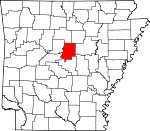
Faulkner County, Arkansas Basics:


Faulkner County Arkansas - Government Site

Population: 118,692
Area: 648 square miles
County seat: Conway
Area code(s) in use: 501
Time zone: CST
High school graduate or higher: 88.8%
Bachelor's degree or higher: 26.2%
Median household income: $49,008
Persons in poverty: 14.6%
Home ownership rate: 65.2%
Mean travel time to work: 24.4 minutes


Adjacent counties:
Cleburne  Conway  Lonoke  Perry  Pulaski  Van Buren  White  
Find in Arkansas

Map of the Faulkner County area


Our detail map of Faulkner County shows the Faulkner County, Arkansas boundary lines and other interesting items.

Places in Faulkner County, Arkansas

  Airports     show all on map

Arkavalley Airport, Bobwhite Hill Ranch Airport, Cantrell Farms Airport, Chael Airport, Conway Regional Hospital Heliport, Dennis F Cantrell Field Airport, Ira's Airstrip, Naylor Field Airport, Pine Village Airport, Poe's Airport, Rak Airport, Vilonia Airport

  Bridges     show all on map

Fishtrap Bridge, Hardin Bridge, King Bridge, Shaw Bridge, Terry Bridge (historical), Whiteoak Bridge

  Buildings     show all on map

Air - Evacuation Lifeteam 30, Arkansas Childrens Home, Arkansas Game and Fish Enforcement, Beaverfork Volunteer Fire Department, Cato Volunteer Fire Department, Centerville Volunteer Fire Department, Conway Drug Task Force, Conway Fire Department Station 1, Conway Fire Department Station 2, Conway Fire Department Station 3, Conway Fire Department Station 4, Conway Fire Department Station 5, Conway Fire Department Station 6, Conway Fire Department Station 7, Conway Police Department, Damascus Police Department, East Cypress Fire Department, Enola Volunteer Fire Department, Faulkner County Courthouse, Faulkner County Emergency Squad, Faulkner County Sheriff's Office, Greenbrier Police Department, Greenbrier Volunteer Fire Department, Greenbrier Volunteer Fire Station, Guy Police Department, Guy Volunteer Fire Department, Highway 286 East Volunteer Fire Department, Hill Top Volunteer Fire Department, Holland Fire Department, Human Development Center Ambulance, Liberty Volunteer Fire Department Station 1, Liberty Volunteer Fire Department Station 2, Mayflower Police Department, Mayflower Volunteer Fire Department, Metropolitan Emergency Medical Service - Liberty, Metropolitan Emergency Medical Service Conway, Metropolitan Emergency Medical Service Greenbrier, Mount Vernon Volunteer Fire Department, Pine Village Volunteer Fire Department, Saltillo Volunteer Fire Department, Torreyson Library, Twin Groves Fire Station, University of Central Arkansas Police, Vilonia Municipal Fire Department, Vilonia Police Department, Wescon Volunteer Fire Department, Wooster Volunteer Fire Department

  Capes     show all on map

Long Point, Picnic Point

  Cemeteries     show all on map

Acklin Graveyard, Adkisson Cemetery, Antioch Cemetery, Beryl Cemetery, Bethlehem Cemetery, Birmingham Cemetery, Brown Cemetery, Cadron Gap Cemetery, Cadron Valley Cemetery, Carter Cemetery, Center Hill Cemetery, Copperas Springs Cemetery, Cypress Valley Cemetery, Duncan Gap Cemetery, Estep Cemetery, Frauenthal Cemetery, Friendship Cemetery, Hardin Cemetery, Hardy Cemetery, Harmony Cemetery, Hartje Cemetery, Hawthicket Cemetery, Heffington Cemetery, Henderson Cemetery, King Cemetery, Liberty Cemetery, Macedonia Cemetery, Marcus Hill Cemetery, Martinville Cemetery, Mayflower Cemetery, McGinty Cemetery, McMillian Cemetery, McNew Cemetery, Mode Cemetery, Mortar Creek Cemetery, Mount Olive Cemetery, Mount Pleasant Cemetery, Mount Psyam Cemetery, Mount Vernon Cemetery, Needs Creek Cemetery, New Liberty Cemetery, Oak Bowery Cemetery, Oak Grove Cemetery, Oakland Cemetery, Old Texas Cemetery, Pearson Cemetery, Pleasant Branch Cemetery, Pleasant Valley Cemetery, Pleasant Valley Cemetery, Ray Cemetery, Republican Cemetery, Round Mountain Cemetery, Saint Joseph Cemetery, Salem Cemetery, Shady Grove Cemetery, Sharon Cemetery, Siloam Cemetery, Sinai Cemetery, Spires Cemetery, Springhill Cemetery, Stone Cemetery, Thorn Cemetery, Vilonia Cemetery

  Churches     show all on map

Antioch Missionary Baptist Church, Baileys Chapel (historical), Baptist Student Union, Barney Church of Christ, Batesville Church (historical), Beryl Baptist Church, Bethel Church, Bethlehem Baptist Church, Bethlehem Church, Bibleway Church, Black Fork Missionary Baptist Church, Bono Baptist Church, Brumley Baptist Church, Cadron Church (historical), Cadron Ridge Landmark Missionary Baptist Church, Calvary Baptist Church, Caney Valley Church, Cato Church, Cedar Glade Assembly of God Church, Cedar Hill Church, Center Point Baptist Church, Central Baptist Church, Christ Temple Holiness Church, Church of Christ, Church of Christ, Church of Christ, Clinton Chapel Baptist Church, Cold Springs Church, Colonial Missionary Baptist Church, Conway Lake Church, Crossroads Church, Cypress Valley Methodist Church, Ebenezer Methodist Church, Emmanuel Baptist Church, Fairview Church, Faulkner Gap Church, First Assembly of God Church, First Baptist Church, First Baptist Church, First Christian Church, First Church of the Nazarene, First Presbyterian Church, First United Methodist Church, Friendship Baptist Church, Friendship Missionary Baptist Church, Gold Creek Baptist Church, Grace of God Full Gospel Church, Graham Chapel Methodist Church, Greenbrier United Methodist Church, Happy Hollow Baptist Church, Harlan Park Assembly of God Church, Harmony Baptist Church, Holland Methodist Church, Hopewell Church (historical), Jones Chapel (historical), Jones Hill Baptist Church, Knap Church, Marcus Hill Church, Mars Hill Church, McGintytown Assembly of God Church, McNew Chapel (historical), Methodist Student Center, Mount Carmel Methodist Church, Mount Gale Baptist Church, Mount Nebo Church, Mount Olive Church (historical), Mount Pleasant Church, Mount Tabor Church, Mount Zion Baptist Church, Mountain Grove Baptist Church, Naylor Baptist Church, Naylor Methodist Church, Needs Creek Baptist Church, New Bethel Baptist Church, New Home Church, New Hope Baptist Church, New Liberty Church (historical), Northside Church, Northside Church of Christ, Oak Bowery Baptist Church, Oakland Methodist Church, Old Liberty Baptist Church, Old Salem Church (historical), Peace Lutheran Church, Pickles Gap Baptist Church, Pilgrim Rest Missionary Baptist Church, Pinnacle Spring Tabernacle, Pleasant Branch Church (historical), Pleasant Grove Baptist Church, Pleasant Grove Church (historical), Pleasant Hill Methodist Church, Pleasant Valley Baptist Church, Providence Church (historical), Round Mountain Church, Saint James Christian Methodist Episcopal Church, Saint Joseph Catholic Church, Saint Peters Episcopal Church, Saint Peters Rock Church, Salem Baptist Church, Salem United Methodist Church, Second Baptist Church, Shady Grove Baptist Church (historical), Shady Grove Church (historical), Shady Grove Church (historical), Sharon Baptist Church, Sharon Church (historical), Soda Valley Free Will Baptist Church, Solomon Grove Baptist Church, Spring Hill Church (historical), Star Gap Church (historical), Sulphur Springs Baptist Church, The Church of Jesus Christ of Latter Day Saints, Troutman Chapel, Union Baptist Church, Union Grove United Methodist Church, University Church of Christ, Vilonia Baptist Church, Vilonia United Methodist Church, White City Church, White Oak Church, Woodrow Church, Zion Grove Baptist Church

  Cliffs     show all on map

Cato Point, Mansfield Bluff, Pin Oak Break

  Crossings     show all on map

Beaverdam Ford (historical), Cow Ford, Davenport Ford, Interchange 124, Interchange 125, Interchange 127, Interchange 129, Interchange 135, Lawson Ferry (historical), Mallet Ford, Powell Ford, Quinn Ford, Red River Ford, Slaty Ford, West Ford

  Dams     show all on map

Bailey Lake Dam, Beaver Fork Lake Dam, Bivans Lake Dam, Blacks Lake Dam, Blacks Lake Number Two Dam, Browns Lake Dam, Brushlake Dam, Carter Lake Dam, Davis Lake Dam, Days Lake Dam, Dears Pond Dam, Deihl Lake Dam, Gentry Lake Dam, Jewell Lake Dam, Lake Bennett Dam, Lake Carol-Dan Dam, Lake Conway Dam, Lake Conway Nursey Pond Dam, Lawrence Lake Dam, Meers Lake Dam, Montgomery Lake Dam, Nalholz Lake Dam, Parks Lake Dam, Robbins Lake Dam, Roberts Minnow Pond Dam, Stevens Lake Dam, Stone Lake Dam, Toad Suck Ferry Lock and Dam, Torian Lake Dam, Tupelo Bayou Site One Dam, Tupelo Bayou Site Two Dam, Watson Lake Dam, Williams Lake Dam, Wisley Lake Dam

  Gaps     show all on map

Acklin Gap, Bailey Gap, Bass Gap, Berry Gap, Birmingham Gap, Cadron Gap, Carmichael Gap, Cascade Gap, Charles Gap, Dearmond Gap, Duncan Gap, Faulkner Gap, Hinson Gap, House Gap, Irwin Gap, Mabry Gap, Pickle Gap, Pinnacle Point Gap, Powell Gap, Rocky Gap, Roden Mill Gap, Snow Gap, Stanley Gap, The Narrows, Waller Gap

  Guts     show all on map

Bell Slough

  Hospitals     show all on map

Conway Regional Medical Center, Conway Regional Rehabilitation Hospital

  Lakes     show all on map

Adams Lake (historical), Boone Pond, Cobb Lake (historical), Gold Lake (historical), Grassy Lake, Greens Lake (historical)

  Locales     show all on map

Adams Landing, Art Pond Landing, Ballard Landing, Bearden-Fowler Store (historical), Brannon Landing, Brazears Store (historical), Bream Nest Landing, Cadron Valley Country Club, Camp Kiwanis, Con-Ark Village Shopping Center, Conway City Landfill, Conway Country Club, Conway Towne Centre Shopping Center, Crafton Landing, Edwards Landing, Faulkner Plaza Shopping Center, Hartwick Mill (historical), Haydens Store (historical), Hi-way Landing, Hietts Store (historical), Jacks Landing, Kapps Landing, Langstons Store (historical), Laurel Plaza Shopping Center, Lawrence Landing, Muns Store (historical), Palarm Creek Landing, Paradise Landing, Pooles Landing, Rodans Mill (historical), Sport Haven Landing, Toad Suck Ferry, Whittens Store (historical), Woffords Store (historical)

  Parks     show all on map

Airport Park, Bell Slough State Wildlife Management Area, Cadron Settlement Park, Camp Robinson State Wildlife Management ARea, Centerville Park, Crest Lawn Memorial Park, Estes Stadium, Fifth Avenue Park, Fletcher Bend Public Use Area, Gatlin Park, Laurel Park, Mountain View Park, Pierce Creek Public Boat Landing, Robert W Young Memorial Stadium

  Populated Places     show all on map

Acklin Gap (historical), Barney, Belk Corner, Beryl, Bessie (historical), Bono, Bristol (historical), Brockington Corner, Brumley, Cadron (historical), Caney, Cato, Center Point, Centerville, Chadwick (historical), Conway, Duncans Gap (historical), Enders, Enola, Funston, Garland Springs, Gentry Corner, Gleason, Gold Creek, Gold Lake Estates, Greenbrier, Guy, Hamlet, Hawthicket (historical), Holland, Lakeview Acres, Linder, Lollie, Martinville, Mayflower, McGintytown, Mount Vernon, Naylor, Old Linder (historical), Old Texas, Otto, Palarm, Pickles Gap (historical), Pinnacle Springs (historical), Pleasant Valley, Preston, Providence (historical), Red Hill, Republican, Rolling Hills, Round Mountain, Rowlett (historical), Salem (historical), Saltillo, Shady Grove, Soda Valley, Springhill, Sunny Gap (historical), Twin Groves, Vilonia, Wooster

  Post Offices     show all on map

Conway Post Office, Damascus Post Office, Martinville Post Office (historical), Republican Post Office (historical)

  Reservoirs     show all on map

Bailey Lake, Beaver Fork Lake, Bivans Lake, Blacks Lake, Blacks Lake Number Two, Browns Lake, Brushlake Reservoir, Carter Lake, Davis Lake, Days Lake, Dears Pond, Deihl Lake, Gentry Lake, Jewell Lake, Lake Bennett, Lake Carol-Dan, Lake Conway, Lake Conway Nursery Pond, Lawrences Lake, Meers Lake, Montgomery Lake, Murray Lake, Nalholz Lake, Parks Lake, Pool Eight, Roberts Pond, Robins Lake, Stevens Lake, Stone Lake, Torian Lake, Tupelo Bayou Site One Reservoir, Tupelo Bayou Site Two Reservoir, Watson Lake, Williams Lake, Wisley Lake

  Ridges     show all on map

Cadron Ridge, Cedar Ridge, Clinton Mountain, Devils Backbone, Donald Ridge, Dun Hill, Duncan Ridge, Easterwood Mountain, Fairview Ridge, Horseshoe Mountain, Kaney Ridge, Negro Hill, North Cadron Ridge, Rock Ridge

  Schools     show all on map

Antioch School (historical), Arkansas Christian College (historical), Barley School (historical), Barney School (historical), Belmont School (historical), Bethel School (historical), Black Fork School (historical), Bob Courtway Middle School, Bono School (historical), Brannan School (historical), Brewers School (historical), Browns School (historical), Burks School (historical), Cadron Gap School (historical), Caney School (historical), Carl Stuart Middle School, Center Point School (historical), Central Baptist College, Central College for Young Women (historical), Chinquapin School (historical), Conway High East School, Conway High School, Conway High West School, Conway Junior High School, Conway Middle School, Cross Roads School (historical), Curtis School (historical), Davis School (historical), Dew Drop School (historical), Duncan School (historical), Ebenezer School (historical), Ellen Smith Elementary School, Enola Elementary School, Enola High School, Fairside School, Fairview School (historical), Fairview School (historical), Florence Mattison Elementary School, Friendship School (historical), Garland Springs School (historical), Germantown School (historical), Glover School (historical), Green School (historical), Greenbrier Eastside Elementary School, Greenbrier Elementary School, Greenbrier High School, Greenbrier Junior High School, Greenbrier Middle School, Greenbrier Westside Elementary School, Guy Perkins School, Guy-Perkins Elementary School, Guy-Perkins High School, Happy Hollow School (historical), Haw Thicket School (historical), Hendrickson School (historical), Hendrix College, Horseshoe Mountain School (historical), Ida Burns Elementary School, Jeffries School (historical), Jim Stone Elementary School, Julia Lee Moore Elementary School, Ledrick School (historical), Liberty School, Lollie School (historical), Marguerite Vann Elementary School, Marshall School (historical), Mayflower Elementary School, Mayflower High School, Mayflower Middle School, Melrose School (historical), Mount Meto School (historical), Mount Pisgah School (historical), Mount Tabor School (historical), Mount Vernon Elementary School, Mount Vernon High School, Mount Vernon-Enola Elementary School, Mount Vernon-Enola High School, Naylor School (historical), New Hope School (historical), Nutter School (historical), Oak Bowery School (historical), Oak Grove School (historical), Oakland School (historical), Oakland School (historical), Oakvale School (historical), Peabody School (historical), Perkins School (historical), Pickles Gap School (historical), Pine Street High School, Pleasant Valley School (historical), Red Hill School (historical), Reeves School (historical), Republican School (historical), Rocky Ridge School (historical), Rowlett School (historical), Ruth Doyle Intermediate School, Saint Joseph High School, Sallie Cone Elementary School, Shady Grove School (historical), Shady Grove School (historical), Sharon School (historical), Solomon Grove School, Springhill School (historical), Stony Point School (historical), Sunny Gap School (historical), Theodore Jones Elementary School, Tucker School (historical), Union Grove School (historical), Union Valley School (historical), University of Central Arkansas, Vilonia Elementary School, Vilonia High School, Vilonia Junior High School, Vilonia Middle School, Vilonia Primary School, Walnut Grove School (historical), Washam School (historical), Whiteoak School (historical), Woodrow School (historical), Wooster School (historical)

  Streams     show all on map

Bailey Branch, Bass Creek, Batesville Creek, Beaver Creek, Beaver Fork, Beaverdam Creek, Bentley Creek, Big Branch, Birmingham Branch, Black Fork, Brier Branch, Buck Branch, Cadron Creek, Caney Creek, Caney Creek, Caney Creek, Cardin Branch, Cedar Branch, Cedar Branch, Cedar Creek, Chadwick Creek, Clear Creek, Clifton Branch, Cove Creek, Cypress Creek, Cypress Creek, DeBerry Branch, East Fork Cadron Creek, Fairview Creek, Gay Branch, Gold Creek, Gold Creek, Greenbrier Creek, Hall Branch, Harve Creek, Hatcher Branch, Haw Creek, Jacks Fork, Kaney Creek, King Branch, Little Caney Creek, Little Creek, Little Creek, Little Cypress Creek, Little Greenbrier Creek, Little Palarm Creek, Lost Creek, Middle Fork Cypress Bayou, Mile Creek, Mill Creek, Mortar Creek, Muddy Bayou, Needs Creek, Nichols Creek, North Fork Cypress Bayou, Panther Creek, Peavine Creek, Pickle Gap Creek, Pierce Creek, Plum Creek, Prairie Creek, Rattan Branch, Shilling Branch, Soda Creek, South Fork Cypress Bayou, Stillhouse Branch, Stone Dam Creek, Strain Branch, Tarkington Creek, Trobough Branch, Tucker Creek, Tupelo Bayou, Tupelo Creek, Turkey Creek, White Oak Branch, White Oak Creek, Wilson Branch, Wolf Branch

  Summits     show all on map

Bailey Mountain, Bald Hill, Ballard Hill, Batesville Mountain, Bayou Mountain, Beckette Mountain, Billy Goat Hill, Blaney Hill, Buffalo Hump, Cascade Mountain, Dalton Mountain, Garland Mountain, Hardin Hill, Holland Hill, Mount Arva, Mount Pleasant, Pisgah Mountain, Reynolds Mountain, Rosin Hill, Round Mountain, Snow Hill, Soda Mountain, Springfellor Hill, Sturgis Hill, Tater Hill, Tater Hill, Webb Hill, White Oak Mountain, Whitmore Mountain, Wilson Hill, Wilson Hill

  Swamps     show all on map

Brushy Pond, Duck Pond, Flag Pond, Goose Pond

  Towers     show all on map

KCON-AM (Conway), KFCA-AM (Conway), KHDX-FM (Conway), KTOD-FM (Conway), KUCA-FM (Conway)

  Valleys     show all on map

Cadron Valley, Caples Hollow, Happy Valley, Soda Valley, Wolf Hollow, Wooley Hollow,

Faulkner County, Arkansas Population By Race (2012 estimate)

RacePopulation
WhiteFaulkner County White population 101,244101,244  
BlackFaulkner County Black population 12,81912,818
MixedFaulkner County Mixed population 2,2552,255
AsianFaulkner County Asian population 1,4241,424
American IndianFaulkner County American Indian population 831830
Hawaiian & Pacific IslanderFaulkner County Hawaiian & Pacific Islander population 119118

Additional population tables :
State population table
Arkansas population by county