Conway County, Arkansas Basics:


Conway County Arkansas - Government Site

Population: 21,250
Area: 552 square miles
County seat: Morrilton
Area code(s) in use: 501
Time zone: CST
High school graduate or higher: 83.0%
Bachelor's degree or higher: 14.4%
Median household income: $32,625
Persons in poverty: 23.4%
Home ownership rate: 73.8%
Mean travel time to work: 22.7 minutes
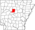
Adjacent counties:
Faulkner  Perry  Pope  Van Buren  Yell  

Find in Arkansas

Map of the Conway County area


Our detail map of Conway County shows the Conway County, Arkansas boundary lines and other interesting items.

Places in Conway County, Arkansas

  Airports     show all on map

Brickey Private Airport, Conway County Hospital Heliport, Heifer Creek Ranch Airport, Morrilton Airport, Morrilton Municipal Airport, Petit Jean Park Airport

  Arches     show all on map

Petit Jean Natural Bridge

  Bends     show all on map

Portland Bottoms, Willow Bend

  Bridges     show all on map

Cedar Creek Bridge

  Buildings     show all on map

Ada Valley Fire Station, Birdtown Fire Station, Blackwell - Kenwood Volunteer Fire Department, Center Ridge Fire Station, Cleveland Fire Station, Conway County Courthouse, Conway County Library, Conway County Sheriff's Office, Hillcreek Fire Station, Jerusalem Fire Station, Med - Tech Emergency Medical Services of Conway County, Menifee Fire Station, Menifee Police Department, Morrilton City Hall, Morrilton Police Department, Morrilton Railroad Station, Morrilton Volunteer Fire Station 1, Oppelo Police Department, Oppelo Volunteer Fire Station, Overcup Fire Station, Petit Jean Fire Station, Plummerville Police Department, Plummerville Volunteer Fire Department, Saint Vincent Fire Station, Sardis Fire Station, Southern Christian Childrens Home, Springfield Fire Department District 1, University of Arkansas Community College at Morrilton Campus Police

  Canals     show all on map

Point Remove Canal

  Capes     show all on map

Blue Point, Windy Point

  Cemeteries     show all on map

Adams Cemetery, Barnes Cemetery, Beeson Cemetery, Bizzell Cemetery, Boltman Cemetery, Brents Cemetery, Bryant Cove Cemetery, Campground Cemetery, Cato Cemetery, Cedar Creek Cemetery, Cedar Creek Cemetery, Cleaver Cemetery, Cooks Cemetery, Dunham Cemetery, Elmwood Cemetery, Fonville Cemetery, Friendship Cemetery, Grandview Cemetery, Halbrooks Cemetery, Hallett Cemetery, Happy Bend Cemetery, Higgins Cemetery, Holly Springs Cemetery, Kilgore Cemetery, Lanty Cemetery, Lewisburg Cemetery, Lowder Cemetery, Mallet Town Cemetery, McClaren Cemetery, McCullough Cemetery, McKay Cemetery, Middleton Cemetery, Mount Abel Cemetery, Mount Pisgah Cemetery, Mount Pleasant Cemetery, Mount Vernon Cemetery, Mount Vernon Cemetery, Mount Zion Cemetery, Nichols Cemetery, Oak Grove Cemetery, Pleasant Hill Cemetery, Plumerville Cemetery, Prospect Cemetery, Reid Cemetery, Robertsville Cemetery, Sacred Heart Cemetery, Saint Josephs Cemetery, Saint Marys Cemetery, Salem Cemetery, Scroggin Cemetery, Sharron Cemetery, Stover Cemetery, Sunnyside Cemetery, Upchurch Cemetery, West Cemetery, Whitehead Cemetery, Wiedower Cemetery, Wilson Cemetery, Wolfe Cemetery, Woolverton Mountain Cemetery

  Census     show all on map

Center Ridge Census Designated Place

  Channels     show all on map

The Narrows

  Churches     show all on map

Bald Knob Church, Bethel Church, Bethlehem Church, Calvary Baptist Church, Cedar Grove Church, Center Ridge Baptist Church, Cove Chapel, Downtown Church of Christ, First Assembly of God Church, First Baptist Church, First Presbyterian Church, First United Methodist Church, Garden of Gethsemane United Church of God in Christ, Gordons Chapel, Gorman Chapel, Hickory Grove Church, Hopewell Church, Lanty United Methodist Church, Lonoke Church, Missionary Church, Moores Chapel, Mount Hebrew Church, Mount Pisgah Church, Mount Pleasant Church, Mount Zion Church, Mount Zion Church, Mount Zion Church, Mountain View Church, New Hope Baptist Church, New Liberty Church, New Mount Zion Church, New Prospect Church, Oppelo Church, Pilgrim Church, Plainview Church, Pleasant Hill Church, Pleasant Springs Church, Plumerville First Baptist Church, Round Mountain Church, Sacred Heart Catholic Church, Saint Matthew Church, Shady Glade Church, Spring Valley Church, Sweet Home Church, Trinity Lutheran Church, Union Hill Church, Vinson Chapel, Zion Hill Church, Zion Temple Church of God

  Cliffs     show all on map

Molten Bluff, Stouts Point

  Crossings     show all on map

Interchange 101, Interchange 107, Interchange 108, Interchange 112, Interchange 117, Libby Ferry (historical)

  Dams     show all on map

Arkansas Noname 24 Dam, Cargile Lake Dam, East Fork Point Remove Site 11 Dam, East Fork Point Remove Site Eight Dam, East Fork Point Remove Site Five Dam, East Fork Point Remove Site Four Dam, East Fork Point Remove Site Nine Dam, East Fork Point Remove Site Seven Dam, East Fork Point Remove Site Six Dam, East Fork Point Remove Site Ten Dam, East Fork Point Remove Site Three Dam, Fish Lake Dam, Fowler Lake Dam, Lake Abby Dam, Lake Bailey Dam, Lake Jeannette Dam, Lake Lucy Dam, Lake Overcup Dam, Lock and Dam Number Nine, Morrilton Sewage Lake Dam, Payne Lake Dam, Petit Jean Water Supply Dam, Timberlake Dam, West Fork Point Remove Creek Site 12 Dam, West Fork Point Remove Creek Site 13 Dam, West Fork Point Remove Creek Site 14 Dam, West Fork Point Remove Creek Site 15 Dam, West Fork Point Remove Creek Site Five Dam, West Fork Point Remove Creek Site Four Dam, West Fork Point Remove Creek Site Seven Dam, West Fork Point Remove Creek Site Six Dam, Winrock Farms Lake Dam

  Falls     show all on map

Cedar Falls

  Flats     show all on map

Doyle Flat, Sandtown Bottoms

  Gaps     show all on map

Sharps Gap

  Hospitals     show all on map

Saint Anthony's Medical Center, Saint Anthonys Hospital

  Lakes     show all on map

Old River Lake, Tank Lake

  Locales     show all on map

Camp Mitchell, Camp Peniel, Mallet Town, Morrilton Sanitary Landfill, North Hills Shopping Center, Plummers Station, Riverland Shopping Center, Ruby Croom Industrial Park

  Oilfields     show all on map

Jerusalem Gas Field, Old Hickory Gas Field

  Parks     show all on map

Dam Site 9 Public Use Area, Petit Jean State Park, Point Remove Public Use Area, Sequoya Park

  Populated Places     show all on map

Ada, Arthur, Austin, Bethlehem, Birdtown, Blackwell, Blick, Catholic Point, Cedar Creek, Center Ridge, Clebb (historical), Cleveland, Country Estates, Cypress Valley, Deerwood, Divide (historical), Friendship, Gobblers Point, Grandview, Hattieville, Hickory Hill, Hill Creek, Holly Springs, Index (historical), Jerusalem, Kenwood, Lanty, Lewisburg, Lick Mountain, Lone Grove, Lost Corner, Macedonia, McClaren, Menifee, Middleton, Morrilton, Mount Olive, North Hills Subdivision, Northview Subdivision, Old Hickory, Oppelo, Overcup, Pleasant Hill, Plumerville, Pontoon, Rehms Corner, Riverview, Robertsville, Saint Vincent, Sandtown (historical), Solgohachia, Spring Meadows, Springfield, Sunnyside, Wesley Chapel, West (historical), Winrock, Wonderview, Woolverton (historical)

  Post Offices     show all on map

Center Ridge Post Office, Cleveland Post Office, Hattieville Post Office, Jerusalem Post Office, Morrilton Post Office, Solgohachia Post Office, Springfield Post Office

  Reservoirs     show all on map

Cargile Lake, East Fork Point Remove Site 11 Reservoir, East Fork Point Remove Site Eight Reservoir, East Fork Point Remove Site Five Reservoir, East Fork Point Remove Site Four Reservoir, East Fork Point Remove Site Nine Reservoir, East Fork Point Remove Site Seven Reservoir, East Fork Point Remove Site Six Reservoir, East Fork Point Remove Site Ten Reservoir, East Fork Point Remove Site Three Reservoir, Fish Lake, Fowler Lake, Lake Abby, Lake Amanda, Lake Bailey, Lake Elsie, Lake George, Lake Jeannette, Lake Lucy, Lake Overcup, Morrilton Sewage Lake, Payne Lake, Petit Jean State Park Lake, Pool Nine, Roosevelt Lake, Timberlake Reservoir, West Fork Point Remove Creek Site 12 Reservoir, West Fork Point Remove Creek Site 13 Reservoir, West Fork Point Remove Creek Site 14 Reservoir, West Fork Point Remove Creek Site 15 Reservoir, West Fork Point Remove Creek Site 16 Reservoir, West Fork Point Remove Creek Site Five Reservoir, West Fork Point Remove Creek Site Four Reservoir, West Fork Point Remove Creek Site Seven Reservoir, West Fork Point Remove Creek Site Six Reservoir, Winrock Farms Lake

  Ridges     show all on map

Buck Ridge, Petit Jean Mountain

  Schools     show all on map

Center School, East Side Elementary School, Hickory Hill School, Lords School, Morrilton High School, Morrilton Junior High School, Morrilton Male and Female College (historical), Morrilton Middle School, Nemo Vista Elementary School, Nemo Vista High School, North Side Elementary School, Petit Jean Technical College, Reynolds Elementary School, Sacred Heart School, Saint Elizabeth School, Union Chapel School, West Side Kindergarten, West Side Kindergarten School, Wonderview Elementary School, Wonderview High School

  Streams     show all on map

Barns Branch, Brindley Creek, Brock Creek, Buck Branch, Canady Branch, Caney Creek, Caney Creek, Cedar Branch, Cedar Creek, Cooks Branch, Creben Creek, Devils Creek, East Fork Point Remove Creek, Gap Creek, Green Creek, Hall Branch, Hill Creek, Hog Branch, Kuhn Bayou, Lick Branch, Miller Bayou, Miller Branch, Overcup Creek, Point Remove Creek, Point Remove Creek Old Channel, Pool Hollow Branch, Prairie Creek, Prairie Creek, Racetrack Branch, Rock Creek, Rocky Branch, Sheepskin Creek, Stratton Creek, Sucker Creek, Sunnyside Creek, Taw Branch, Tenny Creek, West Fork Point Remove Creek

  Summits     show all on map

Boyd Mountain, Bull Mountain, Bunker Mountain, Burrow Mountain, Cedar Mountain, Chambers Mountain, Cole Mountain, Cove Mountain, Devils Knob, Dutton Mountain, Griffin Mountain, Harris Mountain, Harris Mountain, Huett Mountain, Jenkins Mountain, Lick Mountain, Lost Mountain, Money Mountain, Phillips Mountain, Pigeon Roost Mountain, Ragsdale Mountain, Round Mountain, Round Mountain, Round Mountain, Tar Kiln Mountain, Tucker Mountain, Wiedower Mountain, Wildcat Mountain, Woolverton Mountain

  Swamps     show all on map

Cox Lake, Earl Brake, Goose Pond, Turkey Pond

  Towers     show all on map

KVOM-AM (Morrilton), KVOM-FM (Morrilton)

  Valleys     show all on map

Ada Valley, Berry Hollow, Granny Hollow,

Conway County, Arkansas Population By Race (2012 estimate)

RacePopulation
WhiteConway County White population 18,14818,147  
BlackConway County Black population 2,4232,422
MixedConway County Mixed population 404403
American IndianConway County American Indian population 191191
AsianConway County Asian population 8585
Hawaiian & Pacific IslanderConway County Hawaiian & Pacific Islander population 00

Additional population tables :
State population table
Arkansas population by county