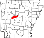
Perry County, Arkansas Basics:


Perry County Arkansas - Government Site

Population: 10,310
Area: 551 square miles
County seat: Perryville
Area code(s) in use: 501
Time zone: CST
High school graduate or higher: 82.0%
Bachelor's degree or higher: 9.7%
Median household income: $42,738
Persons in poverty: 13.9%
Home ownership rate: 82.6%
Mean travel time to work: 34.6 minutes


Adjacent counties:
Conway  Faulkner  Garland  Pulaski  Saline  Yell  

Find in Arkansas

Map of the Perry County area


Our detail map of Perry County shows the Perry County, Arkansas boundary lines and other interesting items.

Places in Perry County, Arkansas

  Airports     show all on map

A J's Airport, Pearson Field Airport

  Bars     show all on map

Busby Shoals, Lee Shoals, May Shoals, Tyler Shoals

  Bends     show all on map

Calfneck Bend, Horseshoe Bend

  Bridges     show all on map

Council Bluffs Bridge

  Buildings     show all on map

Adona Volunteer Fire Department, Bigelow Fire Station, Casa Volunteer Fire Department, Cherry Hill Volunteer Fire Department, Gems Ambulance Services, Harris Brake Lake Fire Department Station 1, Harris Brake Lake Fire Department Station 2, Harris Brake Lake Fire Department Station 3, Hollis Volunteer Fire Department, Houston City Police, Houston Volunteer Fire Department, Nimrod Volunteer Fire Station, Perry County Courthouse, Perry County Sheriff's Office, Perry Police Department, Perry Volunteer Fire Department, Perryville Police Department, Perryville Volunteer Fire Department, Stony Point Volunteer Fire Station, Williams Junction Volunteer Fire Department

  Cemeteries     show all on map

Antioch Cemetery, Aunt Dilly Cemetery, Bland Cemetery, Cardon Cemetery, Casey Cemetery, Deberrie Cemetery, Dry Fork Cemetery, Faisst Cemetery, Faubus Cemetery, Forked Mountain Cemetery, Fowler Cemetery, Garland Cemetery, Goat Bluff Cemetery, Hamilton Cemetery, Harmony Cemetery, Harper Cemetery, Harris Cemetery, Hawks Cemetery, Hope Cemetery, Houston Cemetery, Leach Cemetery, Liberty Cemetery, May Cemetery, McGhee Cemetery, Nimrod Cemetery, Nooner Cemetery, Perry Cemetery, Perryville Cemetery, Pleasant Grove Cemetery, Saint Francis Cemetery, Stony Point Cemetery, Tyndall Cemetery, Viney Grove Cemetery, Wade Cemetery

  Channels     show all on map

Morrilton Cutoff

  Churches     show all on map

Antioch Church, Bethel Church, Harmony Baptist Church, Hickory Grove Church, Mount Carmel Church (historical), Mulberry Church (historical), Nimrod Baptist Church, Oak Grove Church, Pleasant Grove Baptist Church, Pleasant Hill Church, Rose Creek Church, South View Church, Stony Point Baptist Church, Thornburg Baptist Church, Union Valley Baptist Church, Valley Home Church, Webbs Church (historical), Welcome Home Church, Wye United Methodist Church

  Cliffs     show all on map

Goat Bluff, Hopper Bluff, Millie Bluff, Slaty Bluff, Watson Bluff

  Crossings     show all on map

Bales Ford (historical), Cherry Ford, Flynn Ford, Gill Ford, Rocky Crossing, Rocky Ford

  Dams     show all on map

Arkansas Noname 194 Dam, Big Fish Pond Dam, Campbell Lake Dam, Clear Water Lake Dam, Darbys Pond Dam, Deltic Farms Lake Dam, Francis Lake Dam, Harris Brake Auxillary Dam, Harris Brake Dam, Henry Lake Dam, Jones Lake Dam Number One, Jones Lake Dam Number Two, Lake Sylvia Dam, Nimrod Dam, Ouachita Creek Watershed Site One Dam, Ouachita Creek Watershed Site Two Dam, South Fourche Watershed Site Number One Dam, Van Dalsen Lake Dam, Willenberg Lake Dam, Womack Lake Dam

  Falls     show all on map

Sausmann Falls

  Gaps     show all on map

Copperas Gap, Roland Divide, The Narrows, The Narrows

  Guts     show all on map

Keeland Slough, Keeland Slough

  Lakes     show all on map

Bull Lake, Bull Lake Slough, Clear Lake, Open Lake, Winford Brake

  Locales     show all on map

Camp Ouachita, Hamiltons Store (historical), Iron Horse Farm, Lake Sylvia Campground, Lipsmeyers Store (historical), South Fourche Campground, Windle Sodding Farm, Winona Work Center

  Parks     show all on map

Cypress Creek Park, Harris Brake State Wildlife Management Area, Lake Sylvia Recreation Area, Nimrod State Game Management Area, Project Point Recreation Area, Quarry Cove Recreation Area, River Road Recreation Area, South Fourche Roadside Park, Toad Suck Ferry Damsite Park

  Populated Places     show all on map

Adona, Antioch, Aplin, Ava, Bellevue (historical), Bigelow, Bunker Hill, Camp Pershing (historical), Casa, Cherry Hill, Copperas Gap (historical), Deberrie, Dixie (historical), Fourche, Fourche Junction, Graytown, Harmony, Hollis, Homewood, Houston, Kenney (historical), Ledwidge, Little Italy, Moab (historical), New Dixie, Nimrod, Nogal, Oak Grove, Orchard (historical), Perry, Perryville, Pleasant Valley, Ragsdale, Rankin (historical), Satuma, Stony Point, Sweet Home, Thornburg, Toad Suck, West Aplin, Williams Junction

  Post Offices     show all on map

Brizz Post Office (historical)

  Reservoirs     show all on map

Big Fish Pond, Clear Water Lake, Darbys Pond, Deltic Farms Lake, Francis Lake, Harris Brake, Harris Brake Lake, Harris Brake Public Fishing Lake, Henry Lake, Jones Lake Number Two, Lake Sylvia, Ouachita Creek Watershed Site One Reservoir, Ouachita Creek Watershed Site Three Reservoir, Ouachita Creek Watershed Site Two Reservoir, Owens Lake, Rock Creek Lake, South Fouche Site Seven Reservoir, South Fouche Site Six Reservoir, South Fourche Site One Reservoir, The Campbells Lake, Van Dalsen Lake, Willenberg Lake, Womack Lake

  Ridges     show all on map

Bear Creek Mountain, Link Mountain, North Deckard Mountain, Oak Mountain, Rose Creek Mountain, Toms Mountain, Wye Mountain

  Schools     show all on map

Anne Watson Elementary School, Ark School, Ava School (historical), Beene School (historical), Bellevue School (historical), Bethel School (historical), Bigelow High School, Bostic School (historical), Buffalo School (historical), Camp School (historical), Cherry Hill School (historical), Copperas Spring School (historical), Dixie School (historical), East End High School, Ground School (historical), Hawk School (historical), Jay Bird School (historical), Ledwidge School (historical), Link School (historical), Massey School (historical), New Georgia School (historical), Oak Grove School (historical), Perry-Casa Elementary School (historical), Perry-Casa High School (historical), Perryville Elementary School, Perryville High School, Pleasant Grove School (historical), Pleasant Valley School (historical), Rankin School (historical), Satsuma School (historical), Southview School (historical), Stony Point School (historical), Sweet Home School (historical), Teal School (historical), Union Valley School (historical), Walnut Grove School (historical), Westlake School (historical)

  Streams     show all on map

Avery Branch, Ballard Creek, Baskin Creek, Bear Creek, Bearden Branch, Bell Branch, Big Branch, Big Brushy Creek, Big Cove Creek, Big Creek, Big Huston Creek, Blythe Branch, Bob Neal Branch, Brown Creek, Brush Creek, Brush Creek, Caney Creek, Caney Creek, Cedar Branch, Cedar Creek, Cedar Creek, Cedar Gap Branch, Cherry Branch, Clayton Branch, Coffee Creek, Crane Creek, Crystal Prong, Cypress Creek, Danner Creek, Deckard Branch, Dry Fork, Dry Run Creek, Falloff Branch, Flat Cypress Creek, Fourche LaFave River, Grace Creek, Greathouse Creek, Guest Branch, Hambright Creek, Harris Creek, Harris Creek, Haydon Branch, Houston Creek, Howell Creek, Keeland Creek, Little Bear Creek, Little Brushy Creek, Little Cedar Creek, Little Cove Creek, Little Creek, Little Huston Creek, Little Rose Creek, Loston Branch, Lyons Branch, Magie Creek, Marble Branch, McGee Creek, Mill Creek, Mulberry Creek, Narrow Creek, Ouachita Creek, Potato Hill Branch, Rankin Creek, Rock Creek, Rock Creek, Rocky Cypress Creek, Rose Creek, Seaton Creek, Shop Branch, South Fork Brown Creek, South Fourche LaFave River, Sugar Creek, Taylor Creek, Trace Creek, Tyndall Slough, Wallace Creek, West Fork Mill Creek, West Trace Creek, Whisky Creek, White Branch, White Creek, Wright Branch

  Summits     show all on map

Brushy Mountain, Chinquapin Mountain, Chinquapin Mountain, Cove Mountain, Cove Mountain, Deckard Mountain, Flatside Pinnacle, Forked Mountain, Fourche Pinnacle, Jefferson Mountain, Joe Point, Kenney Mountain, Locust Mountain, Long Mountain, Marble Hill, Nancy Mountain, North Deckard Mountain, North Fork Pinnacle, Perry Mountain, Potato Hill, Round Mountain, Sausmann Mountain

  Swamps     show all on map

Turkey Swamp

  Towers     show all on map

Casa Mountain Lookout Tower

  Valleys     show all on map

Brushy Hollow, Bryant Cove, Caney Creek, Hickory Hollow, Holmes Hollow, Long Hollow, Spring Hollow,

Perry County, Arkansas Population By Race (2012 estimate)

RacePopulation
WhitePerry County White population 9,8369,835  
BlackPerry County Black population 206206
MixedPerry County Mixed population 165164
American IndianPerry County American Indian population 8282
AsianPerry County Asian population 2120
Hawaiian & Pacific IslanderPerry County Hawaiian & Pacific Islander population 00

Additional population tables :
State population table
Arkansas population by county