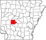
Garland County, Arkansas Basics:


Garland County Arkansas - Government Site

Population: 96,889
Area: 678 square miles
County seat: Hot Springs
Area code(s) in use: 501
Time zone: CST
High school graduate or higher: 86.0%
Bachelor's degree or higher: 20.4%
Median household income: $38,680
Persons in poverty: 19.0%
Home ownership rate: 69.9%
Mean travel time to work: 21.8 minutes


Adjacent counties:
Hot Spring  Montgomery  Perry  Saline  Yell  
Find in Arkansas

Map of the Garland County area


Our detail map of Garland County shows the Garland County, Arkansas boundary lines and other interesting items.

Places in Garland County, Arkansas

  Airports     show all on map

Higdon Field, Memorial Field Airport

  Bays     show all on map

Spencer Bay

  Bridges     show all on map

South Fork Bridge

  Buildings     show all on map

18th East Judicial District Drug Task Force, Airborne Flying Service, Arkansas Game and Fish Commission Law Enforcement Hot Springs Regional Office, Arkansas State Police Troop K, Beth Jacob Hall, Buckville Volunteer Fire Station 1, Buckville Volunteer Fire Station 2, Diamondhead Police Department, Federal Bureau of Investigation Hot Springs Office, Fordyce Bathhouse Vistor Center, Fountain Lake Fire Department Station 1, Fountain Lake Fire Department Station 2, Garland County Courthouse, Garland County Public Library, Garland County Sheriff's Office, Hot Springs City Hall, Hot Springs Fire Department Station 1, Hot Springs Fire Department Station 3, Hot Springs Fire Department Station 4, Hot Springs Fire Department Station 6, Hot Springs Fire Department Station 7, Hot Springs Orphans Home, Hot Springs Police Department, Hot Springs Rehabilitation Center, Hot Springs Village Emergency Medical Services, Hot Springs Village Fire Department Desoto Station, Hot Springs Village Fire Department Station 3, Hot Springs Village Police Department, Jessieville Fire Department Station 1, Jessieville Fire Department Station 2, Jessieville Fire Department Station 3, Lake Hamilton Fire Department Station 1, Lake Hamilton Fire Department Station 2, Lake Hamilton Fire Department Station 3, Lake Hamilton Fire Department Station 4, Lake Hamilton Fire Department Station 5, Lifenet Hot Springs, Lonsdale Fire Department Station 1, Morning Star Fire Department Station 1, Morning Star Fire Department Station 2, Morning Star Fire Department Station 4, Mountain Pine Police Department, Mountain Pine Volunteer Fire Station, Oaklawn Jockey Club Ambulance Services, Piney Fire Department Station 1, Piney Fire Department Station 2, Piney Fire Department Station 3, Piney Fire Department Station 4, Seventy West Fire Department Station 1, Seventy West Fire Department Station 2, Seventy West Fire Department Station 3, Seventy West Fire Department Station 4, Seventy West Fire Department Station 5, Seventy West Fire Department Station 6, United States Forest Service - Ouachita National Forest (Park Security), United States National Park Service Park Security

  Cemeteries     show all on map

Aldrich Cemetery, Avant Cemetery, Avery Cemetery, Bain Cemetery, Brooks Cemetery, Buckville Cemeteries, Caldwell Cemetery, Calvary Cemetery, Coker Cemetery, Cosby Cemetery, Crabtree Cemetery, Cross Roads Cemetery, Cunningham Cemetery, Daley Cemetery, Files Cemetery, Fleming Cemetery, Friendship Cemetery, Gibbons Cemetery, Godwin Cemetery, Greenwood Cemetery, Hollywood Cemetery, Howerton Cemetery, Irwin Cemetery, Jewish Rest Cemetery, Lowe Cemetery, McDowell Cemetery, McGill Cemetery, Memorial Gardens Cemetery, Mount Carmel Creek Cemetery, Mount Tabor Cemetery, Mountain Valley Cemetery, Newkirk Cemetery, Oak Grove Cemetery, Oakwood Cemetery, Ozark Cemetery, Price Cemetery, Robbins Cemetery, Rock Springs Cemetery, Rush Fork Cemetery, Scott Cemetery, Shady Grove Cemetery, Shiloh Cemetery, Spurlin Cemetery, Talley Cemetery, Tranquil Cemetery

  Census     show all on map

Lake Hamilton Census Designated Place, Piney Census Designated Place, Rockwell Census Designated Place

  Churches     show all on map

Antioch Baptist Church, Bethlehem Church, Cedar Glades Baptist Church, Cedar Mountain Church, Central Baptist Church, Church of Christ, Church of Christ, Church of Christ, Church of God, Church of God, Church of God (historical), Congregational House of Israel, County Line Church, Crystal Hill Church, East Side Church, East Side Pentecostal Church, First Baptist Church, First Christian Church, First Church of Christ Scientist, First Church of God, First Free Will Baptist Church, First Lutheran Church, First Pentecostal Church, First United Methodist Church, Fourche a Loupe Church, Gardner United Methodist Church, Glazier Peau Church, Gospel Mission, Grand Avenue United Methodist Church, Greenwood Church, Gum Spring Church, Harveys Chapel Baptist Church, Highland Presbyterian Church, Hillcrest Chapel, Jessieville Church, Kingdom Hall of Jehovahs Witnesses, Lake Hamilton Church, Lakeshore Church, Marble Landmark Church, Meyers Creek Church, Morning Star Church, Mount Olive Church, Mount Tabor Baptist Church, Mount Zion African Methodist Episcopal Church, Mount Zion Church, Mountain Valley Baptist Church, Mountain Valley Church, New Bethel Church, New Home Church, New Hope Church, New Salem Church, Oaklawn United Methodist Church, Park Place Baptist Church, Peak Church, Pearcy Baptist Church, Prince of Peace Lutheran Church, Pullman Heights United Methodist Church, Roanoke Baptist Church, Rock Springs Church, Rose of Sharon Church, Royal Church, Rush Fork Church, Saint Johns Catholic Church, Saint Lukes Episcopal Church, Saint Mary Baptist Church, Saint Marys Episcopal Church, Saint Marys Greek Orthodox Church, Saint Marys Roman Catholic Church, Saint Paul African Methodist Episcopal Church, Second Baptist Church, Sharon Seventh Day Adventist Church, Smith Creek Church, Social Hill Church, Southwest Missionary Baptist Church, Sulphur Springs Church, Temple Pentecostal Church, The Gospel Temple, The Old Country Church, Tigert Memorial Methodist Church, Union Baptist Church, Walnut Grove Church, Walnut Valley Church, Westminister Church

  Crossings     show all on map

Browns Ferry (historical), Higdon Ferry (historical), Kaiser Ferry (historical), Ralston Ferry (historical), Ross Ferry (historical), Smiths Ferry (historical), Spurlins Ferry (historical)

  Dams     show all on map

Arkansas Noname 110 Dam, Arkansas Noname 136 Dam, Belvedere Country Club Lake Dam, Bethel Dam, Big Lake Dam, Blakely Mountain Dam, Camp Clearfork Lake Dam, Carpenter Dam, Desoto Park Dam, Diamond Head Lower Lake Dam, Dillon Dam, Forest Lake Dam, Fountain Lake Dam, Hot Springs Dam Number One, Hot Springs Dam Number Two, Lake Cortez Dam, Lower Dam Number One, Lower Dam Number Two, Middle Dam, Nooner Lake Dam, O'Mahoney Pond Dam, Pineda Dam, Rector Lake Dam, Reynolds Lake Dam, Ricks Dam, Ricks Estate Dam, Roberts Lake Dam, Sanderson Dam, Spring Lake Dam, Upper Dam

  Gaps     show all on map

Buffalo Gap

  Hospitals     show all on map

Advance Care Hospital Hot Springs, HealthPark Hospital, Hot Springs Rehabilitation Center Hospital, Leo N Levi National Arthritis Hospital, Libby Memorial Physical Medical Center, National Baptist Sanatarium, National Park Medical Center, Ouachita Hospital, Rosewood Convalescent Center, Saint Joseph Hospital, Saint Joseph's Mercy Health Center

  Locales     show all on map

Albert Pike Shopping Center, Avant Landing, Balboa Golf Course, Belvedere Country Club, Big Chalybeate Springhouse, Brook Hill Ranch Camp, Camp Clearfork, Camp Couchdale, Camp Tanako, Cedar Fourche Landing, Central City Shopping Center, Cortez Golf Course, Crystal Springs Recreation Site, De Soto Golf Course, Freeman Shopping Center, Garland County Fairgrounds, Garland County Landfill, Gulpha Gorge Campground, Hot Springs Country Club, Irons Fork Landing, Jessieville Work Center, Mowray-Wyatt Plaza Shopping Center, Oaklawn Racetrack, Ouachita Job Corps Conservation Center, Rector Heights Shopping Center, Spillway Landing, Spillway Recreation Site, Three Sisters Landing, Wheatley Plaza Shopping Center, White Sulphur Springs

  Parks     show all on map

Bathhouse Row, Brady Mountain Public Use Area, Buckville Public Use Area, Cedar Fourche Public Use Area, Charlton Public Use Area, Como Square, Crystal Springs Public Use Area, DeSoto Park, Family Park, Gulpha Gorge Picnic Grounds, Hot Springs Central Avenue Historical District, Hot Springs National Park, Iron Spring Roadside Park, Irons Fork Public Use Area, Jaycee Park, Kimberly Lane Park, Lake Ouachita State Park, Lena Landing Public Use Area, Linden Park, Mid-America Park, Spillway Public Use Area, Wade Park, Whittington Park

  Plains     show all on map

Ozark Plateau

  Populated Places     show all on map

Avant, Bear, Beaudry (historical), Blakely, Blue Springs, Bonanza Springs (historical), Bucksville (historical), Cedar Glades (historical), Chandler, Crystal Springs, Crystal Springs Landing, Dripping Springs (historical), Euclid Heights, Fountain Lake, Gladstone (historical), Gulpha (historical), Hamilton, Hawes, Hempwallace, High Point (historical), Hot Springs, Hot Springs Village, Jessieville, Lake Catherine, Lake Hamilton, Lena (historical), Lofton, Lonsdale, Maddox, Meaford (historical), Meyers, Mount Tabor, Mountain Pine, Mountain Valley, Oakwood (historical), Old Bonnerdale, Oma, Ozark Lithia, Peak, Pearcy, Pettyview, Piney, Pleasant Hill, Potash Sulphur Springs (historical), Price, Red Oak, Rockwell, Royal, Spring Lake (historical), Sunshine

  Post Offices     show all on map

Hot Springs Post Office

  Reservoirs     show all on map

Arkansas Noname 136 Reservoir, Bethel Lake, Big Lake, Camp Clear Fork Reservoir, Country Club Lake, Desoto Lake, Dillon Lake, Forest Lake, Fountain Lake, Hot Springs Reservoir, Lake Catherine, Lake Desoto, Lake Hamilton, Lake Ouachita, Lake Pineda, Lake Segovia, Nooner Lake, O'Mahoney Pond, Rector Lake, Reynolds Lake, Ricks Lake, Ricks Pond, Ricks Pond, Roberts Lake, Sanderson Lake, Sleepy Valley Lake, Sleepy Valley Lower Lake, Sleepy Valley Middle Lake, Spring Lake, Tailings Pond

  Ridges     show all on map

Bald Mountain, Bear Mountain, Blakely Mountain, Blue Ouachita Mountain, Cedar Mountain, Crystal Mountain, Glazypeau Mountain, Hickorynut Mountain, Music Mountain, Pearcy Mountain, Short Mountain

  Schools     show all on map

Charles N Rix School, Cutter-Morning Star Elementary School, Cutter-Morning Star High School, Douglas School, Fountain Lake Elementary School, Fountain Lake High School, Gardner Elementary School, Gardner Magnet School, Garland County Community College, Goldstein School, Greenwood Elementary School, Hot Springs High School, Hot Springs Junior High School, Hot Springs Middle School, Jessieville Elementary School, Jessieville High School, Jones Elementary School, Lake Hamilton Elementary School, Lake Hamilton High School, Lake Hamilton Intermediate School, Lake Hamilton Junior High School, Lake Hamilton Middle School, Lake Hamilton Primary School, Lakeside Elementary School, Lakeside High School, Lakeside Intermediate School, Lakeside Junior High School, Lakeside Middle School, Lakeside Primary School, Langston High School, Langston Magnet School, Lee School, Mountain Pine Elementary School, Mountain Pine High School, Oaklawn Elementary School, Oaklawn Magnet School, Park Elementary School, Park Magnet School, Ramble School, Saint Gabriels School, Saint Johns School, Saint Michaels School, Second Baptist School, Southwest Junior High School, Summit School, Valley School

  Springs     show all on map

Big Chalybeate Spring, Whittington Spring

  Streams     show all on map

Angling Creek, Arnold Creek, Baily Branch, Bear Creek, Bear Creek, Bear Creek, Big Blakely Creek, Big Branch, Blocker Creek, Brushy Creek, Bull Bayou, Caney Creek, Cearley Creek, Cedar Creek, Cedar Creek, Cedar Fourche Creek, Clear Creek, Coleman Creek, Cooper Creek, Crudington Creek, Cub Creek, Daley Creek, Dry Fork, East Branch Gulpha Creek, Fisher Creek, Fourche a Loupe Creek, Glazypeau Creek, Gulpha Creek, Hot Springs Creek, Irons Fork, Kelly Creek, Lick Log Branch, Little Bear Creek, Little Blakely Creek, Little Creek, Little Glazypeau Creek, Little Mazarn Creek, Lockett Creek, Lost Creek, Mazarn Creek, McElrath Creek, Merriott Creek, Meyers Creek, Middle Branch Gulpha Creek, Mill Creek, Moccasin Branch, Moccasin Creek, Molly Creek, Mount Carmel Creek, Murphy Creek, Muse Creek, North Fork Ouachita River, North Mill Creek, Owl Creek, Pleasant Run Creek, Poison Creek, Pollard Creek, Rabbit Creek, Redbank Creek, Ritter Creek, Rocky Branch, Rouse Creek, Rush Fork, Sorrells Creek, South Tenmile Creek, Steep Shoals Creek, Still Branch, Stokes Creek, Walnut Creek, Waterfork Creek, White Oak Creek

  Summits     show all on map

Barton Mountain, Blowout Mountain, Brady Mountain, Gobblers Knob, Hot Springs Mountain, Mill Creek Mountain, North Mountain, Ouachita Pinnacle, Pilot Knob, Powell Mountain, Round Mountain, Short Mountain, Smith Pinnacle, Smith Point, Sugarloaf Mountain, Trap Mountain, West Mountain

  Towers     show all on map

KALR-FM (Hot Springs), KBHS-AM (Hot Springs), KBMB-FM (Hot Springs), KQUS-FM (Hot Springs), KSBC-FM (Hot Springs), KXOW-AM (Hot Springs), KZNG-AM (Hot Springs)

  Valleys     show all on map

Hogpen Hollow, The Gorge,

Garland County, Arkansas Population By Race (2012 estimate)

RacePopulation
WhiteGarland County White population 85,26285,262  
BlackGarland County Black population 8,1398,138
MixedGarland County Mixed population 2,0352,034
AsianGarland County Asian population 775775
American IndianGarland County American Indian population 678678
Hawaiian & Pacific IslanderGarland County Hawaiian & Pacific Islander population 9796

Additional population tables :
State population table
Arkansas population by county