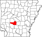
Hot Spring County, Arkansas Basics:


Hot Spring County Arkansas - Government Site

Population: 33,417
Area: 615 square miles
County seat: Malvern
Area code(s) in use: 501
Time zone: CST
High school graduate or higher: 82.9%
Bachelor's degree or higher: 12.8%
Median household income: $39,652
Persons in poverty: 14.2%
Home ownership rate: 72.6%
Mean travel time to work: 28.7 minutes


Adjacent counties:
Clark  Dallas  Garland  Grant  Montgomery  Saline  

Find in Arkansas

Map of the Hot Spring County area


Our detail map of Hot Spring County shows the Hot Spring County, Arkansas boundary lines and other interesting items.

Places in Hot Spring County, Arkansas

  Airports     show all on map

Gillespie Strip Airport, Heard Airport, Hot Spring County Memorial Hospital Heliport, Malvern Municipal Airport, Prince Field

  Bays     show all on map

Slunger Bay, Tigre Bay

  Bridges     show all on map

Old Rockport Bridge

  Buildings     show all on map

Arkansas Department of Corrections Quachita River Unit, Bismarck Fire Department Main Station, Bismarck Willow Road Station, Bonnerdale Volunteer Fire Department, Donaldson City Marshal, Friendship Police Department, Glen Rose Volunteer Fire Department, Glen Rose Volunteer Fire Department Gifford Station, Glen Rose Volunteer Fire Department Military Road Station, Hot Spring County Courthouse, Hot Spring County Library, Hot Spring County Sheriff's Office, Lono - Rolla Volunteer Fire Department Substation 2, Lono - Rolla Volunteer Fire Department Substation 3, Lono Rolla Volunteer Fire Department Station 1, Magnet Cove Volunteer Fire Department, Malvern City Hall, Malvern Fire Department, Malvern Police Department, Morning Star Fire Department Station 3, New de Roche Fire Department, North Malvern Fire Station, Ouachita Fire Department, Ouachita Fire Department Donaldson Station, Ouachita Fire Department Station 3 Substation, Perla Police Department, Perla Volunteer Fire Department, Point Cedar Volunteer Fire Station, ProMed Ambulance Malvern, Rockport Mount Willow Volunteer Fire Department, Rockport Police Department, South Malvern Volunteer Fire Department, South Malvern Volunteer Fire Substation, Southwest Rural Community Volunteer Fire Department Main, Southwest Rural Community Volunteer Fire Department Substation

  Cemeteries     show all on map

Alford Cemetery, Beason Cemetery, Beth Jacob Cemetery, Cooper Cemetery, Cunningham Cemetery, De Roche Cemetery, Dillard Cemetery, Ebenezer Cemetery, Estep Cemetery, Forrest Hill Cemetery, Free Hill Cemetery, Gibson Cemetery, Gray Cemetery, Holstein Cemetery, Jones Cemetery, Lone Hill Cemetery, Lono Cemetery, Manning Cemetery, Mazarn Chapel Cemetery, McClendon Cemetery, Medlock Cemetery, Midway Cemetery, Mount Pleasant Cemetery, Neighbors Cemetery, Oak Bower Cemetery, Oak Ridge Cemetery, Oma Cemetery, Ouachita Cemetery, Perla Gate Cemetery, Phillips Cemetery, Pleasant Hill Cemetery, Pleasant Hill Cemetery, Prince Cemetery, Rest Haven Cemetery, Rockport Cemetery, Sardis Cemetery, Spencer Cemetery, Valley Cemetery, Ward Cemetery

  Census     show all on map

Magnet Cove Census Designated Place

  Churches     show all on map

Anchor Baptist Church, Antioch Church, Baptist Church, Baptist Temple of Malvern, Bethel African Methodist Episcopal Church, Bethlehem Church, Big Creek Church, Bismarck Chapel, Bismarck Church, Bismarck United Methodist Church, Bonnerdale Church, Butterfield Missionary Baptist Church, Calvary Church of God in Christ, Center Hill Church, Church of Christ, Clear Creek Church, Cooper Assembly of God Church, Damascus Church, De Roche Church, Emmanuel Baptist Church, Fairhaven Missionary Baptist Church, Faith Baptist Church, Faith Temple Apostolic Church, First Assembly of God Church, First Baptist Church, First Baptist Church, First Presbyterian Church, First United Methodist Church, First United Pentecostal Church, Forest Hill Church, Francois Church, Free Hill Church, Freewill Baptist Church, Gilead Baptist Church, Glen Rose Church, Glen Rose Church, Glen Rose Church, Grants Chapel United Methodist Church, Greater New Hope Baptist Church, Happy Hollow Church, Harp Missionary Baptist Church, Hickory Grove Church, Huskey Church, Keith Memorial United Methodist Church, L'Eau Frais Church, Landmark Baptist Church, Liberty Chapel, Magnet Cove Baptist Church, Magnet Cove United Methodist Church, Malvern Church of the Nazarene, Malvern Seventh Day Adventist Church, Mill Creek Baptist Church, Morning Star Church, Mount Willow Baptist Church, Mount Zion Baptist Church, Mount Zion Baptist Church, Mountain Valley Church, New Hope Church, North Malvern Assembly of God Church, Oak Bower Church, Oak Hill Church, Ouachita Church, Peaceful Valley Church, Philippi Church, Pleasant Grove Church, Pleasant Hill Church of Christ, Point Cedar United Methodist Church, Prairie Bayou Church, Riverside Baptist Church, Rockdale Church, Saginaw Church, Saint Johns Catholic Church, Saint Paul Church of God in Christ, Saint Pauls United Methodist Church, Sardis Church, Second Baptist Church, Sharon Rose Missionary Baptist Church, South Main Missionary Baptist Church, Tabernacle of Praises, Taylors Chapel Baptist Church, Third Assembly of God Church, Valley Church, Wesleyan Chapel, West End Church of God in Christ

  Crossings     show all on map

Interchange 83, Interchange 91, Interchange 97, Interchange 98

  Dams     show all on map

Arkansas Noname 27 Dam, Clearwater Lake Dam, Crouchwood Lake Dam, F Jones Lake Dam, Kinzey Lake Dam, Remmel Dam

  Flats     show all on map

Elmo Flats

  Guts     show all on map

Cox Bayou, Drowning Slough

  Hospitals     show all on map

Hot Spring County Medical Center

  Islands     show all on map

Morrison Island

  Locales     show all on map

Bonnerdale, Cove Creek Station (historical), Hot Spring County Industrial Park, Justus Mill (historical), Malvern Country Club, Malvern Shopping Center

  Mines     show all on map

Diamond Jo Quarry

  Parks     show all on map

Caddo Drive Recreation Area, Centennial Park, Edgewood Recreation Area, Lake Catherine State Park, Oak Bower Recreation Area, Point Cedar Picinic Area, Shouse Ford Public Use Area

  Populated Places     show all on map

Abco, Antioch, Beaton, Bismarck, Bonnerdale, Brown Springs, Butterfield, Caney, Central, Cove Creek (historical), Cross Roads, De Roche, Diamondhead, Donaldson, Duffie (historical), Durian (historical), Elmore (historical), Etta (historical), Faber, Fleming (historical), Friendship, Gifford, Glen Rose, Harp, Jones Mills, Lambert, Landers, Lono, Magnet Cove, Malvern, Midway, Morning Star, Mount Moriah, Oak Bower, Oak Grove, Old De Roche, Perla, Point Cedar, Rockport, Rolla, Saginaw, Sanders (historical), Shorewood Hills, Social Hill, Twin Oak (historical), Walco (historical), Wayside (historical), Whittington, Witherspoon, Wyandotte (historical)

  Post Offices     show all on map

Donaldson Post Office, Jones Mills Post Office, Lake Catherine Post Office (historical), Lecroy Post Office (historical), Malvern Post Office

  Reservoirs     show all on map

Clearwater Lake, Crouchwood Lake, De Gray Lake, Jones Lake, Kinzey Lake, Lake Bobbie, Lake Catherine, Lower Lake, Lucinda Lake

  Ridges     show all on map

Cook Mountain, DeLisle Hills, Easely Mountain, Emory Mill Mountain, Grapevine Mountain, Indian Mountain, Jack Mountain, Narrow Mountain, Point Cedar Mountains, Trap Mountain

  Schools     show all on map

Antioch School (historical), Bismarck Elementary School, Bismarck High School, Bismarck Middle School, Donaldson School, Fairview School, Fields Elementary School (historical), Gifford School, Glen Rose Elementary School, Glen Rose High School, Glen Rose Middle School, L. C. Smith Elementary School, Magnet Cove Elementary SChool, Magnet Cove Elementary School, Magnet Cove High School, Malvern Elementary School, Malvern High School, Malvern Junior High School, Mountain Valley School (historical), Ouachita Elementary School, Ouachita High School, Ouachita Vocational Technical School, Pratt Elementary School (historical), Rockport School (historical), Smith Elementary School, Wilson Elementary School

  Streams     show all on map

Antioch Creek, Basin Creek, Bayou Dee, Beauchamp Creek, Big Hill Creek, Black Branch, Blakely Creek, Boss Island Creek, Brown Springs Branch, Buck Branch, Caney Creek, Cedar Creek, Chamberlain Creek, Chatman Creek, Clear Creek, Cove Creek, Curl Creek, De Roche Creek, DeLisle Creek, Easley Creek, Falls Creek, Goodman Branch, Greasy Creek, Holly Creek, Jackson Creek, Keisler Creek, Kokomo Creek, Lee Creek, Little L'Eau Frais Creek, Lost Creek, Lucinda Creek, Mill Creek, Ninemile Creek, North Fork Blakely Creek, Philippi Creek, Point Cedar Creek, Prairie Bayou, Reyburn Creek, Sanders Creek, Slunger Creek, Stone Quarry Creek, Stony Creek, Tenmile Creek, Tenmile Creek, The Branch, Thomas Creek, Tigre Creek, Town Creek, Valley Creek, West Fork DeLisle Creek, Wiggins Creek

  Summits     show all on map

Needles Eye Mountain, Shinn Mountain

  Towers     show all on map

Bismarck Lookout Tower, KBOK-AM (Malvern), KBOK-FM (Malvern), KISI-FM (Malvern), KLAZ-FM (Hot Springs), KRZB-TV (Hot Springs)

  Valleys     show all on map

Long Hollow, Steep Hollow,

Hot Spring County, Arkansas Population By Race (2012 estimate)

RacePopulation
WhiteHot Spring County White population 28,73928,738  
BlackHot Spring County Black population 3,8103,809
MixedHot Spring County Mixed population 568568
American IndianHot Spring County American Indian population 167167
AsianHot Spring County Asian population 134133
Hawaiian & Pacific IslanderHot Spring County Hawaiian & Pacific Islander population 3333

Additional population tables :
State population table
Arkansas population by county