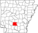
Dallas County, Arkansas Basics:


Dallas County Arkansas - Government Site

Population: 7,971
Area: 667 square miles
County seat: Fordyce
Area code(s) in use: 870
Time zone: CST
High school graduate or higher: 80.8%
Bachelor's degree or higher: 10.2%
Median household income: $30,309
Persons in poverty: 18.0%
Home ownership rate: 69.0%
Mean travel time to work: 19.1 minutes


Adjacent counties:
Calhoun  Clark  Cleveland  Grant  Hot Spring  Ouachita  
Find in Arkansas

Map of the Dallas County area


Our detail map of Dallas County shows the Dallas County, Arkansas boundary lines and other interesting items.

Places in Dallas County, Arkansas

  Airports     show all on map

Dallas County Hospital Heliport, Fordyce Municipal Airport

  Buildings     show all on map

Carthage Volunteer Fire Department, Cooterneck Volunteer Fire Station, Dallas County Courthouse, Dallas County Sheriff's Office, Emergency Ambulance Service Fordyce, Fordyce Fire Department, Fordyce Police Department, Holly Springs Fire Station, Manning Rural Volunteer Fire Station, Ouachita Area Fire Station, Sparkman Fire Department, Sparkman Fire Station Old Station, Sparkman Police Department, Temperance Hill Volunteer Fire Department, Tulip - Princeton Fire Department

  Cemeteries     show all on map

Barnes Cemetery, Benton Cemetery, Bethel Cemetery, Brazeale Cemetery, Bryant Cemetery, Calwell Chapel Cemetery, Centerpoint Cemetery, Crowder Cemetery, Dedman Cemetery, DeLamar Cemetery, Dixon Cemetery, Erby Cemetery, Hampton Springs Cemetery, Hardcastle Cemetery, Harmony Church Cemetery, Harrison Cemetery, Henderson Cemetery, Herring Cemetery, Holeman Cemetery, Lee Cemetery, Liberty Cemetery, Macedonia Cemetery, McDonald Cemetery, Mount Carmel Cemetery, Oak Grove Cemetery, Oakland Cemetery, Old New Hope Cemetery, Princeton Cemetery, Smith Cemetery, Sparkman Cemetery, Sparkman Cemetery, Stevenson Cemetery, Tanyard Cemetery, Taylor Cemetery, Thomas Cemetery, Tulip Cemetery, Turner Cemetery, Vetter-Kauffman Cemetery, Wheelers Cemetery, Williams Cemetery

  Churches     show all on map

Beulah Church, Centerpoint Church, Chapel Hill Church, Cypress Church, Eaglette Church, Ebenezer Church, First Baptist Church, First Baptist Church, First Presbyterian Church, First United Methodist Church, Hopewell Church, Hunters Chapel, Lee Ridge Church, Lee Ridge Church, Macedonia Church, Macedonia Church, Mount Gillard Baptist Church, Mount Olivet Church, Mount Paron Church, Mount Zion Church, Mount Zion Methodist Church, New Bethel Church, New Hope Baptist Church, Oak Grove Church, Pilgrims Rest Church, Pine Crest Church, Princeton Methodist Church, Rock Springs Church, Round Hill Church, Saint Johns Church, Sardis Methodist Church, Shady Grove Baptist Church, Stony Point Church, Temperance Hill Church, Toomey Church, Zion Church

  Crossings     show all on map

Lees Ferry (historical), Mornings Ferry (historical)

  Dams     show all on map

Jacobs Lake Dam, Kervin Lake Dam Number One Dam, Lake Lansdale Dam

  Guts     show all on map

Alsobrook Slough, Black Slough, Hickory Flats Slough, Long Slough

  Hospitals     show all on map

Dallas County Medical Center

  Lakes     show all on map

Horseshoe Lake, Long Lake, Round Lake, Shell Lake

  Locales     show all on map

Ben Few Campground, Fordyce Country Club, Nix Ferry, Rucks Landing, The Mall Shopping Center

  Parks     show all on map

Charlotte Street Historic District

  Populated Places     show all on map

Beech Grove, Bucksnort, Bunn, Carthage, Cooney, Cruse (historical), Dalark, Eagletie, Fairview, Farindale, Fordyce, Forrest Bonner, Heine (historical), Holly Springs, Ivan, Ivy, Jacinto, Jackson (historical), Manning, New Hope, Nix (historical), North Fordyce, Oakhurst (historical), Ouachita, Pine Grove, Princeton, Ramsey, Round Hill, Saline (historical), Sparkman, Tulip, Wave, Welchs Shop (historical), Willow

  Post Offices     show all on map

Ivan Post Office

  Reservoirs     show all on map

Jacobs Lake, Kervin Lake Number One, Lake Lansdale

  Schools     show all on map

Carthage Elementary School, Carthage High School, Fordyce Elementary School, Fordyce High School, Fordyce Middle School, J E Wallace Elementary School (historical), Patterson Grammar School (historical), Sparkman Elementary School, Sparkman High School

  Springs     show all on map

Dutherage Spring

  Streams     show all on map

Barlow Creek, Beach Branch, Bear Creek, Beaverdam Slough, Beech Creek, Beech Creek, Black Branch, Boyd Creek, Brooks Creek, Brushy Creek, Bryant Creek, Bubler Branch, Camp Creek, Campground Creek, Canada Creek, Cane Creek, Casa Massa Creek, Clark Creek, Cooker Branch, Cow Head Creek, Cypress Creek, Dry Branch, Dry Creek, Dry Creek, Dyer Moro Creek, East Fork Tulip Creek, Futch Branch, Garner Creek, Green Creek, Guice Creek, Gum Creek, Hall Creek, Hall Creek, Handcock Creek, Horse Branch, Hurricane Creek, Jordon Creek, Jug Creek, Little Cypress Creek, Little Cypress Creek, Martin Creek, Matthews Creek, Miles Creek, Mitchell Branch, Mud Creek, Populi Creek, Pride Branch, Red Branch, Sand Creek, Schoolhouse Branch, Shell Lake Slough, Simmons Creek, Smith Creek, Spy Branch, Stokes Branch, Taylor Branch, Tenmile Creek, Tunstle Creek, West Fork Tulip Creek, White Oak Creek, White Oak Creek, Williams Creek, Zion Creek

  Towers     show all on map

KBJT-AM (Fordyce), Key Hill Lookout Tower, KQEW-FM (Fordyce),

Dallas County, Arkansas Population By Race (2012 estimate)

RacePopulation
WhiteDallas County White population 4,4404,439  
BlackDallas County Black population 3,3723,371
MixedDallas County Mixed population 112111
American IndianDallas County American Indian population 4039
AsianDallas County Asian population 87
Hawaiian & Pacific IslanderDallas County Hawaiian & Pacific Islander population 00

Additional population tables :
State population table
Arkansas population by county