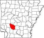
Clark County, Arkansas Basics:


Clark County Arkansas - Government Site

Population: 22,811
Area: 866 square miles
County seat: Arkadelphia
Area code(s) in use: 870
Time zone: CST
High school graduate or higher: 85.2%
Bachelor's degree or higher: 21.6%
Median household income: $32,393
Persons in poverty: 23.7%
Home ownership rate: 66.0%
Mean travel time to work: 18.6 minutes


Adjacent counties:
Dallas  Hot Spring  Montgomery  Nevada  Ouachita  Pike  
Find in Arkansas

Map of the Clark County area


Our detail map of Clark County shows the Clark County, Arkansas boundary lines and other interesting items.

Places in Clark County, Arkansas

  Airports     show all on map

Ashworth Airport, Dexter B Florence Memorial Field Airport, Gurdon Lowe Field Airport

  Basins     show all on map

Chalybeate Valley

  Bends     show all on map

Horseshoe Bend

  Buildings     show all on map

Alpine Volunteer Fire Department, Amity Police Department, Amity Volunteer Fire Department, Arkadelphia City Hall, Arkadelphia Fire Station 1, Arkadelphia Fire Station 2, Arkadelphia Police Department, Arkansas Hall, Beirne Rural Volunteer Fire Department, Birkett Williams Hall, Caddo Center Cafeteria, Caddo Valley Police Department, Caddo Valley Volunteer Fire Department, Clark County Courthouse, Clark County Jail, Clark County Library, Clark County Sheriff's Office, Concer Hall, Curtis Fire Department, Dailey Hall, Degray Rural Volunteer Fire Station, East Clark County Volunteer Fire Department, Evans Hall, Flennicken Memorial Students Center, Foster Hall, Goodloe Dormitory, Gum Springs Volunteer Fire Department, Gurdon Fire Station, Gurdon Police Department, Haygood Gymnasium, Henderson State University Police Department, Holly Dormitory, Hollywood Fire Station, Huie Library, J R Grant Memorial Administration Building, Johnson Hall, Kansas Community Volunteer Fire Department, McBrien Hall, McElhannon Hall, Mitchell Hall, Mooney Hall, O C Bailey Dormitory, Oaks Dormitory, Okolona Fire Station, Pines Dormitory, Proctor Hall, Riley Library, Smith Hall, Terral-Moore Hall, Whelen Springs Fire Station, Womack Hall

  Canals     show all on map

North Boat Ditch, South Boat Ditch

  Cemeteries     show all on map

Alpine Cemetery, Arkadelphia Cemetery, Arnold Cemetery, Atchley Cemetery, Bethel Cemetery, Bethel Springs Cemetery, Bethlehem Cemetery, Bethlehem Cemetery, Bethsaida Cemetery, Bozeman Cemetery, Brown Cemetery, Brown Cemetery, Brushy Cemetery, Buchanan Cemetery, Callaway Cemetery, Carter Cemetery, Clear Spring Cemetery, Copeland Ridge Cemetery, Curtis Cemetery, Davis Cemetery, Easley Cemetery, Ebenezer Cemetery, Edwards Cemetery, Gardner Cemetery, Golden Cemetery, Greenville Cemetery, Hart Cemetery, Hill Cemetery, Humphrey Cemetery, Jenkins Cemetery, Jones Cemetery, Jones Cemetery, Jordan Cemetery, Kansas Cemetery, Lee Cemetery, Lewis Randolph Grave, Littlejohn Cemetery, McAlly Cemetery, McClanahan Cemetery, Mitchell Cemetery, New Hope Cemetery, Okolona Cemetery, Old Rome Cemetery, Osborn Cemetery, Peeples Cemetery, Pettus Cemetery, Providence Cemetery, Rawles Hill Cemetery, Rest Haven Memorial Gardens, Richland Cemetery, Richwoods Cemetery, Rodgers Cemetery, Rome Cemetery, Rose Hedge Cemetery, Rose Hill Cemetery, Rose Hill Cemetery, Ross Cemetery, Shiloh Cemetery, Sloan Cemetery, Springhill Cemetery, Straightway Cemetery, Strong Cemetery, Stroud Cemetery, Thomas Cemetery, Unity Cemetery, Vaden Cemetery, Washington Hill Cemetery, Wier Cemetery, Wilson Cemetery, Wimbley Cemetery, Wingfield Cemetery

  Churches     show all on map

Baring Cross Missionary Baptist Church, Beech Street Baptist Church, Beirne Baptist Church, Berry Chapel, Bethel Church (historical), Bethlehem Baptist Church, Cedar Grove Baptist Church, Center Grove United Methodist Church, Center Point Baptist Church, Center Ridge Church, Chalybeate Valley Church, Church of Christ, Church of Christ, Church of Christ Holiness, Church of God in Christ, Church of the Nazarene, Clayborn Chapel, Cross Roads Church, David Temple Church of God in Christ, DeGray Baptist Church, East Whelen Baptist Church, Eastern Star Church, Ebenezer Church of God in Christ, Faith Missionary Baptist Church, First Assembly of God Church, First Baptist Church, First Baptist Church, First Christian Church, First Presbyterian Church, First United Methodist Church, First United Methodist Church, First United Pentecostal Church, Friendship Church, Gennesaret Missionary Baptist Church, Gum Springs Baptist Church, Harmony Hill Baptist Church, Harts Chapel, Hearn Church, Holly Grove Church, Hollywood Baptist Church, Hollywood United Methodist Church, Lakeview Baptist Church, Landmark Missionary Baptist Church, Macedonia Church, Macedonia Primitive Baptist Church, Manchester United Methodist Church, Maryetta Church, Midway Church, Mount Bethel Baptist Church, Mount Canaan Baptist Church, Mount Moriah Baptist Church, Mount Olive Baptist Church, Mount Zion Baptist Church, Mount Zion United Methodist Church, New Antioch Church, New Caney Church, New Home Church, New Life Church, New Ronok Church, Oak Grove Church, Oak Grove Church, Okolona Baptist Church, Park Hill Baptist Church, Piney Grove Church, Piney Ridge Church, Providence Church, Richmond Hill Church, Richwoods Baptist Church, Saint Andrew United Methodist Church, Saint Clair Church, Saint Marys Catholic Church, Saint Michaels Episcopal Church, Saint Paul African Methodist Episcopal Church, Salem Church, Second Baptist Church, Shady Grove Baptist Church, Shady Grove Baptist Church, Shady Grove Church, Shady Grove Church, Shiloh Baptist Church, Shiloh Church, Smyrna United Methodist Church, South Fork Baptist Church, Sweet Home Church, Sycamore Grove Church, Third Street Baptist Church, Thompson Chapel, Trinity United Methodist Church, Union Church (historical), Union Grove Church, Unity Baptist Church, Vaden Church, Victor Temple, Walnut Street Missionary Baptist Church, West End Presbyterian Church

  Cliffs     show all on map

Walters Bluff

  Crossings     show all on map

Interchange 54, Interchange 63, Interchange 69, Interchange 73, Interchange 78, Riffe Ford

  Dams     show all on map

Barksdale Lake Dam, Boswell Lake Dam, Country Club Lake Dam, De Gray Dam, Degray Reregulating Dam, Dwiggins Lake Dam, Gross Lake Dam, Gurdon Pond One Dam, Gurdon Pond Two Dam, Kirksey Reservoir Dam

  Guts     show all on map

Bolin Slough, Half Moon Slough, Minnie Slough

  Hospitals     show all on map

Baptist Health Medical Center - Arkadelphia, Baptist Health Medical Center Arkadelphia, Clark County Health Center, Clark County Memorial Hospital

  Lakes     show all on map

Barton Lake, Deceiper Lake, Horn Lake, Nowlin Pond, Salt Lake

  Locales     show all on map

Arkadelphia Country Club, Arkadelphia Wastewater Treatment Plant, Brushy Creek Access Point, Center Point, Clear Spring Camp, Copeland Ridge Community Hall, Davidson Camp, Gurdon Golf Course, Human Development Center, Kathleen Siding, Pine Plaza Shopping Center, South Central

  Parks     show all on map

A U Williams Stadium, Alpine Ridge Recreation Area, Amity Landing Recreation Area, Arkadelphia Central Park, Arlie Moore Landing Use Area, Clark County Fairgrounds, Cox Creek Landing Recreation Area, De Gray State Park, Feasler Park, Haygood Stadium, Highway 7 Recreation Area, Iron Mountain Recreation Area, Lakeview Recreation Area, Lenox Marcus Recreation Area, Lower Lake Recreation Area, Ozan Point Recreation Area, Rab Rodgers Stadium, Spillway-Dam Recreation Area, Sturgis Field

  Populated Places     show all on map

Alpine, Amity, Arkadelphia, Barringer, Beirne, Bethel, Boswell, Britt (historical), Burtsell, Caddo Valley, Central, Clear Spring, Curtis, Daleville, De Gray, Dobyville, Elm (historical), Fendley, Gravel Junction, Graysonia, Griffithtown, Gum Springs, Gurdon, Halfway, Haretown, Hearn (historical), Hebron (historical), Hollywood, Joan, Kansas, Keyton (historical), Knoxville, Lenox, Love Creek, Majors, Meeks Settlement, Midway, Native (historical), Okolona, Pike Junction, Red Springs, Richwoods, Shakertown, Smithton, Smithton (historical), Smyrna, Sycamore, Trace, Vaden, Whelen Springs

  Post Offices     show all on map

Arkadelphia Post Office, Beirne Post Office

  Reservoirs     show all on map

Boswell Lake, Country Club Lake, Degray Reregulating Lake, Dwiggins Lake, Gross Lake, Gurdon Pond One, Gurdon Pond Two, Kirksey Reservoir, Lake Barksdale

  Ridges     show all on map

Chalybeate Mountain, Little Mountain

  Schools     show all on map

Amity Elementary School, Amity High School, Arkadelphia High School, Cabe Middle School, Center Ridge School (historical), Centerpoint Intermediate School, Central Primary School, Central School, Fendley School (historical), Free Hill School (historical), Goz Junior High School, Goza Middle School, Gurdon High School, Gurdon Middle School, Gurdon Primary School, Henderson State University, Holly Grove School (historical), Louisa Perritt Primary School, Ouachita Baptist University, Peake Elementary School, Peake High School (historical), Perritt Elementary School

  Springs     show all on map

Ball Spring, Boiling Springs, West Gum Springs

  Streams     show all on map

Antoine River, Ball Branch, Bankhead Creek, Bear Creek, Beaver Creek, Beaver Slough, Beech Branch, Beech Creek, Bell Creek, Black Branch, Black Branch, Blue Hole Creek, Boggy Creek, Bradshaw Creek, Brushy Creek, Brushy Creek, Brushy Creek, Brushy Creek, Brushy Creek, Buck Creek, Caddo River, Caney Creek, Caney Creek, Caney Creek, Caney Creek, Coffee Creek, Copeland Ridge Branch, Cox Creek, Cypress Creek, De Gray Creek, Deceiper Creek, Deep Slough, Dry Branch, Easley Branch, Flat Creek, Gentry Creek, Gus Still Creek, Hollywood Creek, L'Eau Frais Creek, Lick Branch, Lick Creek, Little Antoine Creek, Little Antoine Creek, Little Beech Branch, Little Brushy Creek, Little Creek, Little De Gray Creek, Little Deceiper Creek, Little Missouri River, Locket Creek, Long Creek, Long Slough, Love Creek, Marshall Branch, Mathews Creek, McCargo Creek, McNeeley Creek, Mill Creek, Mill Creek, Mill Creek, Moore Creek, Moores Creek, Patterson Branch, Pearson Creek, Pruitt Creek, Rocky Branch, Rowe Creek, Saline Bayou, Sandy Branch, Sandy Branch, Sandy Creek, Scrouge Creek, Shaw Creek, Skipper Creek, Smithton Branch, South Fork Terre Noire Creek, Stroud Creek, Terre Noire Creek, Terre Rouge Creek, Trailer Creek, Tupelo Creek, Waggle Creek, Walnut Branch, West Fork Beech Creek, White Oak Creek, White Oak Creek, White Oak Creek, White Oak Slough, Williams Branch, Winding Slough, Wingfield Creek, Wolf Creek, Yancey Creek

  Summits     show all on map

Ashworth Hill, Bull Mountain, Gores Peak, Sugarloaf Knob, Whetstone Mountain

  Swamps     show all on map

Cypress Brake

  Towers     show all on map

Alpine Lookout Tower, KDEL-FM (Arkadelphia), KETG-TV (Arkadelphia), KGAP-FM (Gurdon), KSWH-FM (Arkadelphia), KVRC-AM (Arkadelphia), Okolona Lookout Tower

  Trails     show all on map

Runyan Trail,

Clark County, Arkansas Population By Race (2012 estimate)

RacePopulation
WhiteClark County White population 16,78916,788  
BlackClark County Black population 5,4295,429
MixedClark County Mixed population 319319
American IndianClark County American Indian population 137136
Hawaiian & Pacific IslanderClark County Hawaiian & Pacific Islander population 00

Additional population tables :
State population table
Arkansas population by county