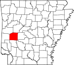
Montgomery County, Arkansas Basics:


Montgomery County Arkansas - Government Site

Population: 9,339
Area: 780 square miles
County seat: Mount Ida
Area code(s) in use: 870
Time zone: CST
High school graduate or higher: 81.1%
Bachelor's degree or higher: 11.0%
Median household income: $33,240
Persons in poverty: 22.7%
Home ownership rate: 80.2%
Mean travel time to work: 24.6 minutes


Adjacent counties:
Clark  Garland  Hot Spring  Howard  Pike  Polk  Scott  Yell  

Find in Arkansas

Map of the Montgomery County area


Our detail map of Montgomery County shows the Montgomery County, Arkansas boundary lines and other interesting items.

Places in Montgomery County, Arkansas

  Airports     show all on map

Bearce Airport, Chasewood Landing, Mount Ida Municipal Airport, Williams Ranch Airport

  Buildings     show all on map

Caddo Gap Volunteer Fire Department, Joplin Volunteer Fire Station, Montgomery County Courthouse, Montgomery County Sheriff's Office, Mount Ida Volunteer Fire Department, Norman Volunteer Fire Department, Oden Pencil Bluff Volunteer Fire Department Station 2, Oden Volunteer Fire Department Station 1, Pine Ridge Volunteer Fire Department, Sims Volunteer Fire Department, South Fork Volunteer Fire Department, Southwest Emergency Medical Service Mount Ida, Sulphur Laverna Volunteer Fire Department Station 1, Sulphur Laverna Volunteer Fire Department Station 2

  Capes     show all on map

Denby Point

  Cemeteries     show all on map

Adams Cemetery, Alley Cemetery, Amason Cemetery, Amerson Cemetery, Barber Cemetery, Bassinger Cemetery, Bates Cemetery, Bethel Cemetery, Big Fir Cemetery, Black Cemetery, Black Springs Cemetery, Blish Cemetery, Bonds Cemetery, Breashears Cemetery, Brewer Cemetery, Brushy Cemetery, Caney Cemetery, Chapel Cemetery, Coffman Cemetery, County Line Cemetery, Cox Cemetery, East Washita Cemetery, Edwards Cemetery, Ewing Cemetery, Family Cemetery, Fancy Hill Cemetery, Ferguson Cemetery, Forbes Cemetery, Garrett Cemetery, Gaston Cemetery, Goodner Cemetery, Gortemiller Cemetery, Grenade Cemetery, Hillside Cemetery, Hopper Cemetery, Howton Cemetery, Huddleston Cemetery, Irby Cemetery, James Cemetery, Jones Cemetery, Jones Cemetery, Jones Valley Cemetery, Joplin Cemetery, Liberty Cemetery, Little Fir Cemetery, Little Fir Cemetery, Lone Valley Cemetery, Macedonia Cemetery, McKinney Cemetery, Middleton-Crooks Cemetery, Montgomery Cemetery, Mount Gilead Cemetery, Mount Ida Cemetery, Mount Olive Cemetery, Mount Zion Cemetery, Mountain Home Cemetery, Mullenix Cemetery, Murphy Cemetery, Music Cemetery, Nelson Cemetery, Newcomb Cemetery, Nicholson Cemetery, Oak Grove Cemetery, Oak Hill Cemetery, Oden Cemetery, Old Salyer Cemetery, Owley Cemetery, Pencil Bluff Cemetery, Pine Ridge Cemetery, Piney Cemetery, Putman Cemetery, Putman Cemetery, Reed Cemetery, Robbins Cemetery, Rock Springs Cemetery, Rocky Cemetery, Rocky Cemetery, Rowton Cemetery, Saint Marks Cemetery, Scott Cemetery, Scott Cemetery, Shirley Cemetery, Stanley Cemetery, Steller Cemetery, Stover Cemetery, Sweethome Cemetery, Tweedle-Vaught Cemetery, Wacaster Cemetery, Waco School Cemetery, West Washita Cemetery, Whitehall Cemetery, Whittington Cemetery, Whittington Cemetery, Whittington-Hiram Cemetery, Wilhite Cemetery, Wilhite Cemetery

  Churches     show all on map

Alamo Missionary Baptist Church, All Saints Catholic Church, Antioch Baptist Church (historical), Barr Memorial Presbyterian Church, Black Springs First Baptist Church, Brushy Creek Baptist Church, Church of Christ, Church of God, Community Bible Baptist Church, County Line Methodist Church, Crystal Hill Church, Evening Light Tabernacle, Faith Tabernacle, Faith Valley Church, Faith Valley Landmark Missionary Baptist Church, First Assembly of God Church, First Church of the Nazarene, Forest Hill Church (historical), Gaston Community Church, Grenade Church, Harbor Chapel, Hillside Baptist Church, Hopper Church of Christ, Hurricane Grove Primitive Baptist Church, Lake Ouachita Baptist Church, Landmark Missionary Baptist Church, Liberty Baptist Church, Little Hope Baptist Church, Lone Valley Church of God, Macedonia Church, Macedonia Primitive Baptist Church, Midway Pentecostal Church, Mount Gilead Baptist Church, Mount Gilend Church, Mount Ida Church of God, Mount Ida First Baptist Church, Mount Ida First United Methodist Church, Mount Olive Baptist Church, Mount Pisgah Missionary Baptist Church, Mount Tabor Church, Muddy Creek Church of God, Murphy Baptist Church, Norman Assembly of God Church, Norman First Baptist Church, Norman United Methodist Church, Oak Grove Baptist Church, Oden First Baptist Church, Oden United Methodist Church, Old Mount Tabor Church, Owley Church, Pencil Bluff First Baptist Church, Pine Ridge Baptist Church, Pleasant Valley Baptist Church (historical), Prairie Grove Church of God, Prayer House Tabernacle Church, Providence Church, Refuge Baptist Church, Rocky Church, Saint Marks Church, Saint Pauls Church, Shockey Chapel (historical), Story Church of God, Sulphur Springs Baptist Church, Sweethome Church, Union Church, Union Church, Union Hill Church, Washita Missionary Baptist Church

  Dams     show all on map

Arkansas Noname 186 Dam, Hatfield Lake Dam, Lake Ouachita Nursery Pond Dam, Owens Lake Dam, Tigue Lake Dam

  Gaps     show all on map

Caddo Gap, Logan Gap, Mosquito Gap

  Guts     show all on map

Persimmon Slash, Walker Cypress Slash

  Locales     show all on map

Albert Pike Recreation Area, Big Brushy Recreation Site, Blowout Mountain Scenic Area, CCC Camp, Fancy Hill, Gap Creek Recreation Site, Happy Hills Dairy, Hickory Nut Mountain Campground, Highway 27 Recreation Site, Juneau Spur, Lake Ouachita Vista Point of Interest, Little Fir Recreation Site, Little Missouri Falls Recreation Area, Mauldin, Oden Ranger Station, Oden Work Center, Ouachita Seed Orchard, Roaring Branch Natural Area, Rocky Shoals Campground, Twin Creek Recreation Site, Washita Recreation Site, Womble Ranger Station, Womble Work Center

  Mines     show all on map

Dempsey Cog Bur Barite Mine, McKnight Barite Mine, Pigeon Roost Mine

  Parks     show all on map

Albert Pike Recreation Area, Big Brushy Recreation Site, Big Fir Public Use Area, Collier Spring Recreation Site, Crystal Mountain Scenic Area, Crystal Recreation Area, Denby Point Public Use Area, Dragover Recreation Area, Fulton Branch Recreation Area, Joplin Public Use Area, Little Fir Public Use Area, Little Missouri Falls Recreation Area, River Bluff Recreation Area, Tompkins Bend Public Use Area, Twin Creek Use Area

  Populated Places     show all on map

Alamo, Albert, Alf, B B Junction, Black Springs, Buckhorn, Buddys Landing, Caddo Gap, Chasewood Landing, Cox Spring, Fannie, Fir (historical), Gaston, Gibbs, Hickory Station, Hickory Station (historical), Hog Jaw, Hopper, Huddleston, Hurricane Grove, Imelda (historical), Joplin, Liberty, Little Fir Landing, Lucky (historical), Manfred, Mauldin, Mazarn, Mimosa, Mount Ida, Norman, Oden, Ophir, Owley, Pencil Bluff, Pine Ridge, Plata, Redbird (historical), Rubie, Ruble, Segur, Silver, Sims, Slatington (historical), Story, Sulphur Springs, Sweethome, Union Hill, Washita, Welsh, Whitetown

  Post Offices     show all on map

Black Springs Post Office, Caddo Gap Post Office, Mount Ida Post Office, Norman Post Office, Oden Post Office, Pencil Bluff Post Office, Pine Ridge Post Office, Sims Post Office, Story Post Office

  Ranges     show all on map

Caddo Mountains, Cossatot Mountains, Crystal Mountains

  Reserves     show all on map

Gap Creek Natural Area

  Reservoirs     show all on map

Hatfield Lake, Lake Ouachita Nursery Pond, North Fork Lake, Sylvan Lake (historical), Tigue Lake

  Ridges     show all on map

Bashaw Mountain, Brier Creek Mountains, Broken Rock Mountain, Caddo Mountains, Chalybeate Mountain, Cossatot Mountains, Crystal Mountains, Fodderstack Range, Gardner Mountain, Gaston Mountain, Harold Ridge, Little Mazarn Mountain, Little Raven Mountain, Mauldin Mountain, McGraw Mountain, Muddy Mountain, Oxbow Mountain, Pigeon Roost Mountain, Red Oak Range, Reed Mountain, Rock Row, Smith Mountain, Statehouse Mountain

  Schools     show all on map

Alamo School (historical), Albert School (historical), Barnett School (historical), Ben Craven Elementary School, Big Fir School (historical), Black Springs School (historical), Blue Bell School (historical), Bonner School (historical), Brushy School (historical), Caddo Gap School (historical), Caddo Hills Elementary School, Caddo Hills High School, Caddo Valley Academy (historical), Caney School (historical), Cedar Bluff School (historical), Central School (historical), Chapel School (historical), County Line School (historical), Crystal Hill School (historical), Crystal Hill School (historical), Elnora School (historical), Fancy Hill School (historical), Fiddler Valley School (historical), Fields School (historical), Five Mile School (historical), Friendship School (historical), Gap School (historical), Gaston School (historical), Gibbs School (historical), Grandview School, Grenade School (historical), Haleys School (historical), Hurricane Grove School (historical), Imelda School (historical), Independence School (historical), Jones School (historical), Joplin School (historical), Liberty School (historical), Liberty School (historical), Little Fir School (historical), Logan School (historical), Lone Star School (historical), Lucky School (historical), Manfred Colored School (historical), Manfred School (historical), Mauldin School (historical), Mimosa School (historical), Mount Ida Elementary School, Mount Ida High School, Mount Zion School (historical), Mountain Home School (historical), Mountain Valley School (historical), Mountain View School (historical), Murphy School (historical), Nicholson School (historical), Oak Grove School (historical), Oak Grove School (historical), Oakwood School (historical), Ode Maddox Elementary School, Oden High School, Oklahoma School (historical), Old Bethel School (historical), Owley School (historical), Parks School (historical), Perrin School (historical), Pine Ridge School (historical), Piney Grove School (historical), Pisgah School (historical), Pleasant Hill School (historical), Pleasant Valley School (historical), Pleasant Valley School (historical), Red Bird School (historical), Red Haw School (historical), Richwood School (historical), Rocky Hollow School (historical), Rocky Valley School (historical), Sardis School (historical), Scott School (historical), Shady Grove School (historical), Shady Grove School (historical), Sims School (historical), Slatington School (historical), Story School (historical), Sulphur Springs School (historical), Sweet Home School (historical), Tackett School (historical), Thorney Grove School (historical), Union Hill School (historical), Union Hill School (historical), Waco School (historical), Washita School (historical), Welch School (historical), Woodville School (historical), Yellow Jacket School (historical)

  Springs     show all on map

Buttermilk Springs, Chalybeate Spring, Collier Spring, Cox Spring, Rock Spring, Strawn Springs, West Spring, Wyatt Spring

  Streams     show all on map

Alder Creek, Allen Creek, Barnes Branch, Bear Cave Prong, Bear Wallow Prong, Beech Creek, Big Branch, Big Brushy Creek, Big Cedar Creek, Big Hill Creek, Blaylock Creek, Blue Creek, Bolan Creek, Call Branch, Caney Creek, Cedar Creek, Clear Branch, Clear Creek, Cold Water Creek, Collier Creek, Craft Creek, Crooked Creek, Crump Creek, Cypress Creek, Deer Creek, Denby Creek, Dry Fork, Dry Fork, Dry Mazarn Creek, East Fork Twin Creek, Fiddlers Creek, Fivemile Creek, Fulton Branch, Gap Creek, Gap Creek, Hackberry Creek, Hall Branch, Hamilton Creek, Harris Creek, Harvey Branch, Haw Branch, Hendrix Branch, Hewing Branch, Hole in the Ground Creek, House Branch, Hovel Creek, Huddleston Creek, Hyatt Creek, Irons Creek, Kates Creek, Lick Branch, Lick Creek, Little Brushy Creek, Little Cedar Creek, Little Rainy Creek, Little Sugarloaf Creek, Martin Creek, Mill Creek, Mill Iron Creek, Montgomery Creek, Muddy Creek, Murder Creek, Nealy Branch, North Fork South Fork Ouachita River, Pilot Branch, Polk Creek, Polk Creek, Qualls Creek, Rainy Creek, Rattlesnake Creek, Rattlesnake Creek, Red Branch, Reeves Branch, Rock Creek, Rock Creek, Rocky Creek, Rogers Creek, Rough Creek, Shady Creek, Shirley Creek, Sloan Branch, Smith Creek, Smith Creek, Smith Creek, South Fork Caddo River, South Fork Ouachita River, Story Creek, Sugarloaf Creek, Sulphur Creek, Sweetwater Creek, Swindle Creek, Tea Creek, Twin Creek, Wagner Creek, Wake Creek, Wehunt Creek, West Fiddlers Creek, West Spring Branch, Wheat Creek, Williams Creek, Wilson Creek, Woods Branch

  Summits     show all on map

Bald Mountain, Bear Den Mountain, Bear Mountain, Beardon Mountain, Beardon Mountain, Beck Mountain, Big Round Top Mountain, Blaylock Mountain, Blowout Mountain, Brushy Creek Mountain, Brushy Mountain, Carely Mountain, Cedar Cabin Mountain, Chalybeate Mountain, Christopher Mountain, Cub Mountain, Fancy Hill Mountain, Fodderstack Mountain, Fork Mountain, Gap Mountain, Grapevine Mountain, Hackberry Mountain, High Peak, High Top, Hog Jaw Mountain, Hopper Mountain, Horseshoe Mountain, Jeff Summit Mountain, John Burns Mountain, Kinsey Mountain, Lick Mountain, Little Raven Mountain, Little Round Mountain, Little Round Top Mountain, Locust Mountain, Logan Gap Mountain, Long Mountain, Mast Mountain, Mazarn Mountain, McGill Mountain, Mount Ida, Nelson Mountain, Old Mitchel Mountain, Owens Mountain, Paul Mountain, Phillips Mountain, Pilot Knob, Polk Creek Mountain, Pot Mountain, Pryor Mountain, Rainy Creek Mountain, Rainy Mountain, Rockhouse Mountain, Rocky Creek Mountain, Round Mountain, Round Mountain, Round Mountain, Salmon Mountain, Sandlick Mountain, Sharp Top Mountain, Sherman Mountain, Stevenson Mountain, Stovall Mountain, Strawn Mountain, Suck Mountain, Sugartree Mountain, Thorpe Mountain, Turkey Pen Mountain, Wheeler Mountain, White Mountain, Wolf Mountain

  Towers     show all on map

Gaston Lookout Tower, Hickorynut Lookout Tower, Muddy Mountain Lookout Tower

  Trails     show all on map

Gap Mountain Trail

  Valleys     show all on map

Back Valley, Bear Water Hollow, Chalybeate Spring Hollow, Jones Valley, Pole Branch Hollow, Smoky Hollow,

Montgomery County, Arkansas Population By Race (2012 estimate)

RacePopulation
WhiteMontgomery County White population 8,9198,918  
MixedMontgomery County Mixed population 215214
American IndianMontgomery County American Indian population 9393
AsianMontgomery County Asian population 5656
BlackMontgomery County Black population 4746
Hawaiian & Pacific IslanderMontgomery County Hawaiian & Pacific Islander population 00

Additional population tables :
State population table
Arkansas population by county