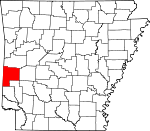
Polk County, Arkansas Basics:
Polk County Arkansas - Government Site
Population: 20,460
Area: 858 square miles
County seat: Mena
Area code(s) in use: 479 870
Time zone: CST
High school graduate or higher: 82.7%
Bachelor's degree or higher: 11.7%
Median household income: $33,479
Persons in poverty: 21.5%
Home ownership rate: 77.6%
Mean travel time to work: 20.3 minutes
Adjacent counties:
Howard Le Flore (OK) McCurtain (OK) Montgomery Pike Scott Sevier
Places in Polk County, Arkansas
Mena Intermountain Municipal Airport Mountain Fork Bridge 18th West Judicial District Drug Task Force,
Acorn Fire Station District 6,
Big Fork Fire Department District 9,
Board Camp Station Fire District 8,
Cherry Hill Station District 7,
Cove Volunteer Fire Station 3,
Dallas Valley Rural Volunteer Fire Department Station 11,
Grannis Fire Station 1,
Grannis Police Department,
Hatfield Station Fire District 4,
Ink Station Fire District 12,
James Flying Service (Air Medical Services),
Mena Fire Department Station 1,
Mena Fire Department Station 2,
Mena Police Department,
Polk County Courthouse,
Polk County Development Center,
Polk County Sheriff's Office,
Potter Fire Department Substation,
Potter Station Fire District 13,
Rocky Fire Station District 5,
Shady Grove Fire and Rescue,
Shady Station Fire District 10,
Southwest Emergency Medical Service,
Vandervoort Fire Station District 14,
Wickes Fire Department Antioch Cemetery,
Baker Cemetery,
Board Camp Cemetery,
Buffalo Cemetery,
Cecil Cemetery,
Cecil Chapel Cemetery,
Center Cemetery,
Cherry Hill Cemetery,
Concord Cemetery,
Corinth Cemetery,
Crystal Hill Cemetery,
Dallas Cemetery,
Daniel Cemetery,
Foote Cemetery,
Foran Cemetery,
Foster Cemetery,
Gann Cemetery,
Gann Cemetery,
Grannis Cemetery,
Heely Cemetery,
Holly Grove Cemetery,
Liberty Cemetery,
Little Cemetery,
Lone Valley Cemetery,
Lower Big Fork Cemetery,
McKinney Cemetery,
Mineral Cemetery,
Mount Calvary Cemetery,
Mount Gillian Cemetery,
Nunley Cemetery,
Oak Grove Cemetery,
Oak Grove Cemetery,
Overturf Cemetery,
Owens Cemetery,
Pinecrest Cemetery,
Pioneer Cemetery,
Pleasant Grove Cemetery,
Pleasant Hill Cemetery,
Rocky Cemetery,
Sexton Cemetery, Shady Cemetery,
Sixmile Cemetery,
Stinett Cemetery,
Tate Cemetery,
Westview Cemetery,
Whole Council of God Cemetery,
Whole Council of God Cemetery,
Yocana Cemetery Acorn Methodist Church,
Alder Springs Church,
Baker Church,
Bethel Chapel,
Bethel Church,
Board Camp Assembly of God Church,
Board Camp Baptist Church,
Board Camp Primitive Baptist Church,
Buffalo Baptist Church (historical),
Calvary Baptist Church,
Cecil Chapel,
Center Church,
Center Point Church,
Cherry Hill Baptist Church,
Christ Episcopal Church,
Christs Church,
Christs Church of Mountain Fork,
Concord Baptist Church,
Corinth Church of God,
Covenant of Life Church,
Crystal Hill Church,
Dallas Avenue Baptist Church,
Faith Missionary Baptist Church,
First Baptist Church,
First Christian Church,
First Freewill Baptist Church,
First Presbyterian Church,
First United Methodist Church,
Foster Chapel (historical),
Free Jesus Name Pentecostal Holiness Church,
Gann Chapel,
Grannis Baptist Church,
Harmony Primitive Baptist Church,
Hatfield First Baptist Church,
Hatfield Freewill Baptist Church,
Holly Grove Missionary Baptist Church,
Holly Springs Church,
Lower Big Fork Baptist Church,
McCauley Church,
Mena Bible Church,
Mena Church of the Nazarene,
Midway Freewill Baptist Church,
Midway Independent Baptist Church,
Mountain View United Methodist Church,
Oak Grove Church,
Old Dallas Methodist Church,
Old Potter Presbyterian Church,
Overturf Church,
Pine Grove Church of Christ,
Piney Church,
Pleasant Grove Church,
Pleasant Grove Church,
Pleasant Hill Church,
Pleasant Hill Freewill Baptist Church (historical),
Rich Mountain Church,
Rocky Methodist Church,
Saint Agnes Catholic Church,
Salem Baptist Church,
Shady Grove Church,
South 71 Church of Christ,
Trinity Lutheran Church,
Two Mile Baptist Church,
Union Church,
Union Grove Freewill Baptist Church,
Union Mission Pentecostal Church of God,
United Church of Grannis,
Vandervoort First Baptist Church,
Vandervoort Methodist Church,
West Valley Church,
Westview Church,
Word of Faith Church,
Yocana Baptist Church Odell Ford Bethesda Lake Dam,
Blue Lake Dam,
Brewer Lake Dam,
Cox Lake Dam,
Dairy Lake Dam,
Faulkner Lake Dam,
Forbis Lake Dam,
Hillcrest Lake Dam,
Irons Fork Creek Watershed Site 1 Dam,
Ivey Lake Dam,
J and B Lake Dam,
Jenkins Lake Dam,
Lake Mena Dam,
Lake Wilhelmina Dam,
Land Processing Lake Dam,
Number Name Lake Dam,
Patchett Lake Dam,
Powell Lake Dam,
Reeds Lake Dam,
Shady Lake Dam,
Ward Lake Dam Dicks Gap,
Eagle Gap,
Foran Gap,
Sugartree Gap,
Three Oak Gap,
Wolf Pen Gap Mena Regional Health System Hospital,
Wilhelmina Medical Center Shady Lake Bard Springs Recreation Area,
Camp Pioneer,
Camp Wilder (historical),
High Point Camp,
Lionsk Club Golf Course,
Mena Ranger Station,
Mena Work Center,
Menna Visitor Information Station,
Northside Shopping Center,
Ouachita Country Club,
Polk County Fairgrounds,
Polk County Fairgrounds,
Rich Mountain Tower Recreation Area Caney Creek State Wildlife Management Area,
Janssen Park,
Lee McMillian Memorial Park,
Queen Wilhelmina State Park,
Shady Lake Recreation Area Acorn,
Bethel Chapel,
Big Fork,
Board Camp,
Bog Springs,
Buffalo (historical),
Center Point,
Cherry Hill,
Clayton Spur (historical),
Corinth,
Cove,
Dallas,
Eagleton,
Fogel,
Gann (historical),
Grannis,
Hartley,
Hatfield,
Hatton,
Highland,
Holly Grove,
Howard,
Ink,
Lone Valley,
McCauley,
Mena,
Mountain Fork,
Nunley,
Old Cove,
Olivers Chapel,
Opal,
Pine Grove,
Pleasant Hill,
Posey Hollow,
Potter,
Potter Junction,
Rich Mountain,
Rocky,
Roff (historical),
Shady,
Shady Grove,
Two Mile (historical),
Vandervoort,
West Valley,
Wickes,
Yocana Hatton Post Office,
Mena Post Office Ouachita Mountains Black Fork Mountain Wilderness,
Caney Creek Wilderness Aeration Lake,
Bethesda Lake,
Blue Lake,
Brewer Lake,
City of Mena Sewage Logoon,
Cox Lake,
Dairy Lake,
Faulkner Lake,
Forbis Lake,
Hillcrest Lake,
Irons Fork Reservoir,
Ivey Lake,
J and B Lake,
Jenkins Lake,
Lake Wilhelmina,
Mena Lake,
Multipurpose Site One Reservoir,
Patchett Lake,
Powell Lake,
Reeds Lake,
Shady Lake,
Ward Lake Cedar Mountain,
Cow Creek Mountain,
Cross Mountains,
Dallas Mountain,
Fork Mountain,
Fourche Mountain,
Hanna Range,
Long Ridge,
McKinley Mountain,
Middle Mountain,
Missouri Mountains,
Porter Mountain,
Rich Mountain Acorn Elementary School,
Acorn High School,
Acorn School, Alder Springs School (historical),
Baker School (historical), Bell School (historical),
Big Fork School (historical),
Board Camp School (historical),
Bogg Springs School (historical), Bowman Spur School (historical),
Bowmans Spur School (historical), Brumbelow School (historical), Bunch School (historical),
Bunch School (historical), Center School (historical),
Center School (historical),
Cherry Hill School (historical), Cloverleaf School (historical), Concord School (historical), Cross Mountain School (historical),
Crystal Hill School (historical), Dallas School (historical), Eagleton School (historical), Egger Public School (historical), Elm Springs School (historical),
Eureka School, Flat Creek School (historical), Freedom School (historical), Gann School (historical), Gap Creek School (historical),
Happy Hill School (historical), Hartley School (historical),
Hatfield Elementary School,
Hatfield High School (historical), Hatton School (historical),
Heath School (historical), Heath Valley School (historical), Hickory Ridge School (historical), Highland School (historical), Hillard School (historical),
Holly Grove School (historical),
Holly Harshman Elementary School,
Holly Hill School (historical), Holly Springs School (historical),
Hopewell School (historical), Howard School (historical), Independence School (historical),
Independence School (historical), Jackson School (historical), Liberty School (historical),
Lone Valley School (historical),
Louise Durham Elementary School, Lower Big Fork School (historical), Marble Hill School (historical),
Marble Hill School (historical),
McCauley School (historical),
Mena High School,
Mena Middle School, Midway School (historical), Mill Creek School (historical),
Mill Creek School (historical), Mount Clair School (historical), Mount Pleasant School (historical), Mount View School (historical), Mountain Fork School (historical),
Mountain View School (historical), New Bethel School (historical), New Hope School (historical), Nunley School (historical), Oak Hill School (historical), Oak Ridge School (historical),
Old Cove School (historical),
Old Potter School (historical), Olivers Chapel School (historical), Opal School (historical), Ouachita School (historical),
Overturf School (historical), Ozark School (historical),
Ozark School (historical), Pine Hill School (historical),
Piney Grove School (historical),
Piney School (historical), Pleasant Hill School (historical),
Potter School (historical), Ransom School (historical),
Rich Mountain Community College, Rich Mountain School (historical), Rock Spring School (historical), Rocky School (historical),
Rowell School (historical),
Saint Joseph School, Salem School (historical),
School Number 47, Shady Grove School (historical), Shady Point School (historical), Shady School (historical),
Shelton School (historical), Shiloh School (historical),
Shiloh School (historical), Southside School (historical),
Spring Valley School (historical), Springdale School (historical),
Stilwell Elementary School (historical),
Sugar Creek School (historical),
Sunflower School (historical), The Bend School (historical), Thurman School (historical),
Towery School (historical), Towry School (historical), Two Mile School (historical), Union Grove School (historical),
Van Cove Elementary School,
Van Cove High School,
Van-Cove Elementary School,
Van-Cove High School, Vinegar Hill School (historical),
Welcome Home School (historical), West Valley School (historical),
West View School (historical),
Wickes Elementary School,
Wickes High School,
Wickes Middle School, Womack Spur School (historical),
Womack Spur School (historical), Yocana School (historical)
Abernathy Spring,
Alpine Spring,
Bog Springs,
Gillham Springs,
Roaring Spring,
Twin Springs Allen Branch,
Barren Creek,
Big Creek,
Big Fork,
Board Camp Creek,
Boggy Creek,
Brier Creek,
Brier Creek,
Brushy Creek,
Bufram Creek,
Butcherknife Creek,
Calvin Branch,
Camp Creek,
Caney Creek,
Carter Creek,
Cedar Branch,
Cedar Creek,
Cedar Creek,
Chances Creek,
Choctaw Creek,
Clear Fork,
Collins Creek,
Cow Creek,
Cross Creek,
Dallas Creek,
Dry Creek,
East Fork Powell Creek,
East Saline Creek,
Faulkner Branch,
Flat Creek,
Gap Creek,
Gap Creek,
Gap Creek,
Hickory Creek,
Holly Branch,
Holly Creek,
Hoover Creek,
Horsepen Creek,
Indian Creek,
Irons Fork,
Joshling Creek,
Kings Branch,
Lewis Creek,
Lick Branch,
Little Brushy Creek,
Little Coon Creek,
Little Hickory Creek,
Loftis Creek,
Long Branch,
Long Creek,
Mackey Creek,
Macks Creek,
McKinney Creek,
Merren Creek,
Mike Creek,
Mill Creek,
Mill Creek,
Mill Creek,
Mine Creek,
Muddy Creek,
Nancy Branch,
Nesbitt Creek,
Nichols Branch,
North Fork Saline River,
Polk Creek,
Pollock Branch,
Powell Creek,
Prairie Creek,
Queen Creek,
Red Creek,
Robinson Creek,
Rock Creek,
Rock Creek,
Rough Creek,
Shack Creek,
Short Creek,
Slate Creek,
Slaty Creek,
Smoke Rock Creek,
South Fork Saline River,
Southern Creek,
Starkey Creek,
Straight Creek,
Sugar Creek,
Sulphur Creek,
Sulphur Creek,
Thompson Creek,
Turbin Creek,
Turner Creek,
Twomile Creek,
Ward Creek,
Weehunt Branch,
West Creek,
White Creek,
Wolf Creek Baker Mountain,
Bald Knob,
Bear Mountain,
Bee Mountain,
Black Fork Mountain,
Blaylock Mountain,
Blowout Mountain,
Blue Mountain,
Boar Tusk Mountain,
Brush Heap Mountain,
Brushy Knob,
Buckeye Mountain,
Dog Mountain,
Eagle Mountain,
East Hanna Mountain,
Fodderstack Mountain,
Fodderstack Mountain,
Goldsberry Mountain,
High Peak,
High Point,
Hurricane Knob,
Irons Fork Mountain,
Katy Mountain,
Kelsey Mountain,
Lamb Mountain,
Leader Mountain,
Little Round Mountain,
Long Mountain,
Lost Mountain,
Middle Mountain,
Nichols Mountain,
Pilot Mountain,
Pine Mountain,
Potter Mountain,
Quentin Mountain,
Raspberry Mountain,
Rattlesnake Mountain,
Rocky Mountain,
Round Mountain,
Round Mountain,
Round Top Mountain,
Round Top Mountain,
Self Mountain,
Smoke Rock Mountain,
Sugartree Mountain,
Tall Peak,
Tower Mountain,
Turners Mountain,
Weehunt Mountain,
West Hanna Mountain,
Whiskey Peak,
Wolf Pinnacle Bee Mountain Lookout Tower,
KENA-AM (Mena),
KENA-FM (Mena),
KOUA-FM (Mena),
Rich Mountain Lookout Tower Basin Hollow,
Dog Hollow,
Gap Creek Valley,
Long Hollow,
Posey Hollow,

