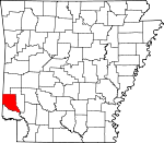
Sevier County, Arkansas Basics:


Sevier County Arkansas - Government Site

Population: 17,194
Area: 565 square miles
County seat: De Queen
Area code(s) in use: 870
Time zone: CST
High school graduate or higher: 66.3%
Bachelor's degree or higher: 8.6%
Median household income: $32,081
Persons in poverty: 26.3%
Home ownership rate: 70.8%
Mean travel time to work: 21.1 minutes


Adjacent counties:
Hempstead  Howard  Little River  McCurtain (OK)  Polk  

Find in Arkansas

Map of the Sevier County area


Our detail map of Sevier County shows the Sevier County, Arkansas boundary lines and other interesting items.

Places in Sevier County, Arkansas

  Airports     show all on map

Community Hospital of De Queen Heliport, De Queen Landing Strip, J Lynn Helms Sevier County Airport

  Bars     show all on map

Cotton Woods Shoals, Green Wood Shoals

  Bridges     show all on map

Dog Town Bridge, Johnson Bridge, Ladds Bridge, Salt Works Bridge, Wood Side Bridge

  Buildings     show all on map

Ben Lomond Volunteer Fire Department, Central Volunteer Fire and Rescue, Cossatot Fire Station, De Queen Fire Station, De Queen Manor Nursing Home, De Queen Police Department, Gillham Volunteer Fire Department, Greens Chapel Volunteer Fire Department, Horatio Fire Department, Lifenet, Incorporated - De Queen (Ambulance Services), Lockesburg Fire Department, Provo Volunteer Fire Department, Ridgeview Lodge Nursing Home, Sevier County Courthouse, Sevier County Sheriff Office, South Central Arkansas Drug Task Force, Southwest Emergency Medical Service DeQueen, Southwest Transport Service (Basic Life Support), United States Fish and Wildlife Pond Creek National Wildlife Refuge Park Security

  Cemeteries     show all on map

Avon Cemetery, Bellville Cemetery, Ben Lomond Cemetery, Boggy Springs Cemetery, Brownstown Cemetery, Cane Creek Cemetery, Chapel Hill Cemetery, Clear Creek Cemetery, Cossatot Cemetery, Cross Trail Cemetery, Fairview Cemetery, Falls Chapel Cemetery, Gillham Cemetery, Greens Chapel Cemetery, Herman Direk Memorial Park, Hopson Cemetery, Horatio Cemetery, Kingree Chapel Cemetery, Lockesburg Cemetery, Mill Creek Cemetery, Millwee Cemetery, Mount Ida Cemetery, New Bethel Cemetery, Norwoodville Cemetery, Oak Grove Cemetery, Oak Grove Cemetery, Old New Hope Cemetery, Old Union Cemetery, Piney Grove Cemetery, Redman Cemetery, Sand Field Cemetery, Smyrna Cemetery, Sunset Acres Cemetery, Sweet Home Cemetery, Ultima Thule Cemetery, Valley Cemetery, West Line Cemetery, West Otis Cemetery, Woffords Chapel Cemetery, Wrights Chapel Cemetery

  Churches     show all on map

Almond Church, Boggy Springs Church, Bradley Chapel, Brownstown Community Church, Carrun Church, Chapel Hill Church, Christian Home Church (historical), Cossatot Church (historical), Dilworth Church, Fairview Church (historical), Falls Chapel Cumberland Presbyterian Church, Geneva Missionary Baptist Church, Gravelly Hill Church, Gravity Point Church, Greens Chapel Methodist Church, Holly Springs Church, Holly Springs Church, Kingree Chapel, Lone Oak Church, Lyons United Methodist Church, Midway Church, Mount Carmel Church, Mount Ida Church, Mount Pleasant Church, New Hope Church, Norwoodville Methodist Church (historical), Old Bellville Church, Old Central Church, Old Union Church, Piney Grove Methodist Church, Pleasant Hill Church, Pullman Methodist Church (historical), Smyrna Church of Christ, Union Church, West Otis Church, Williamson Methodist Church, Woofords Chapel (historical), Wright Chapel, Wrights Chapel

  Crossings     show all on map

Battle Ford, Boring Crossing, Clinton Ford, Flanagan Ford, Gin House Ford, Green Wood Ferry (historical), Hawkins Ford, Kolb Ford, Ladd Ford, Lanes Ferry (historical), Line Ford, McKinney Ford, Moody Shoal Ford, Norris Ferry (historical), Parker Crossing, Rolling Shoal Ford, Sorghum Patch Ford, Stallion Ford, Steel Ford

  Dams     show all on map

Coulter Lake Dam, De Queen Dam, Dierks Dam, Double K Lake Dam, Fraser Pond Dam, Gillham Lake Dam, Lake Hospitality Dam, Process City Lake Dam, Tobin Lake Dam

  Guts     show all on map

Borne Mill Slough, Johnson Slough

  Hospitals     show all on map

De Queen Regional Medical Center

  Lakes     show all on map

Berks Slough, Johnson Lake, Red Lake, Russey Lake

  Locales     show all on map

Bear Creek Junction, Central, Dogtown, Falls Chapel, Mail Ford, Parloma Landing, Rock Hill, Silver Ridge, Town North Shopping Center, West Line, Yellow Banks Landing

  Parks     show all on map

Paraclifta Monument

  Populated Places     show all on map

Antioch (historical), Antrey (historical), Avon, Bellville, Ben Lomond, Blanchard (historical), Brownstown, Chapel Hill, Cheatham, Cornhill (historical), Cowlingsville, Cross Trails (historical), De Queen, Dilworth, Fairview, Geneva, Gillham, Horatio, Kellum, King, Lebanon, Lockesburg, Milford, Millers Crossing, Milrose, Mineral, Neal Springs, Norwoodville, Oak Grove, Oak Grove, Paraclifta (historical), Paraloma, Pennys, Process City, Provo, Pullman, Red Hill (historical), Red Wing, Riddle (historical), Stringtown, Union, Wade, Walnut Springs, West Otis, White Cliffs, Williamson

  Post Offices     show all on map

Ben Lomond Post Office, De Queen Post Office, Lyons Beard Post Office (historical), Norwoodville Post Office (historical), Riddle Post Office (historical)

  Reservoirs     show all on map

Coulter Lake, De Queen Lake, Dierks Lake, Double K Lake, Fraser Pond, Gillham Lake, Lake Hospitality, Process City Lake, Tobin Lake

  Schools     show all on map

Antimony School (historical), Antioch School (historical), Avon School (historical), Baker School (historical), Beacon Hill School, Cane Creek School (historical), Center Grove School (historical), Cooper School (historical), Crooked Ridge School (historical), Cross Trail School (historical), De Queen Elementary School, De Queen High School, De Queen Middle School, De Queen Primary School, Fairview School (historical), Gillham High School (historical), Graves School, Graves School (historical), Holly Grove School (historical), Horatio Elementary School, Horatio High School, Kellum School (historical), King School (historical), Lockesburg Elementary School, Lockesburg High School, Maddux School (historical), Melrose School (historical), Mill Creek School (historical), Morphew School (historical), Mount Pleasant School (historical), Nettle Hill School (historical), Newhope School (historical), Oak Grove School (historical), Piney Grove School (historical), Pleasant Hill School (historical), Pullman School (historical), Redding School (historical), Roundtop School (historical), Sardis School (historical), Shady Grove School (historical), Shockenbach School (historical), Spring Hill School (historical), Union School (historical), Valley School (historical), Wallace Hill School (historical), Walnut Springs School (historical), Woolsey School (historical)

  Streams     show all on map

Almond Creek, Bear Creek, Bellah Creek, Bellville Creek, Blacks Branch, Blue Creek, Bridge Creek, Browns Creek, Buck Creek, Buck Creek, Burke Creek, Cane Creek, Caney Creek, Carters Creek, Cave Creek, Clear Creek, Cold Branch, Cool Easy Creek, Cossatot River, Coulter Branch, Davis Slough, Dry Creek, Hale Creek, Hose Creek, Hurricane Creek, Johns Branch, Johnson Creek, Lee Creek, Lick Creek, Little Bear Creek, Little Bellville Creek, Little Cossatot River, Little Creek, Mill Creek, Mill Creek, Mill Slough, Millwee Creek, Mud Creek, Panther Creek, Pepper Creek, Pond Creek, Price Creek, Roberts Branch, Robinson Creek, Rock Creek, Rolling Fork, Russey Creek, Sand Creek, Sand Creek, Sand Creek, Sand Slough, Sandy Slough, Shepherd Creek, Slate Creek, Spring Creek, Starch Creek, Story Creek, Stringtown Creek, Sycamore Creek, Sycamore Creek, Trent Creek, Twomile Creek, Walnut Springs Creek, White Oak Slough, Wilson Creek, Wilson Creek, Winters Creek, Woolsey Creek, Woolsey Creek

  Summits     show all on map

Steele Hill

  Towers     show all on map

Bethel Lookout Tower, KDQN-AM (De Queen), KDQN-FM (De Queen)

  Valleys     show all on map

Glen Canyon,

Sevier County, Arkansas Population By Race (2012 estimate)

RacePopulation
WhiteSevier County White population 15,38915,388  
BlackSevier County Black population 791790
American IndianSevier County American Indian population 567567
MixedSevier County Mixed population 378378
AsianSevier County Asian population 6968
Hawaiian & Pacific IslanderSevier County Hawaiian & Pacific Islander population 1717

Additional population tables :
State population table
Arkansas population by county