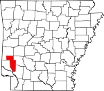
Howard County, Arkansas Basics:
Howard County Arkansas - Government Site
Population: 13,749
Area: 589 square miles
County seat: Nashville
Area code(s) in use: 870
Time zone: CST
High school graduate or higher: 76.0%
Bachelor's degree or higher: 11.3%
Median household income: $35,236
Persons in poverty: 23.7%
Home ownership rate: 65.2%
Mean travel time to work: 19.2 minutes
Adjacent counties:
Hempstead Little River Montgomery Pike Polk Sevier St. Landry (LA)
Places in Howard County, Arkansas
Glenn Winchester Airport,
Howard County Airport Corns Bridge (historical),
Saline Landing Bridge (historical),
Steel Bridge (historical) Athens Fire Department,
Center Point Volunteer Fire Department,
Cottonshed Volunteer Fire Department,
County Line Rural Volunteer Fire Department,
Dierks Police Department,
Dierks Volunteer Fire Department,
Howard County Ambulance,
Howard County Courthouse,
Howard County Sheriff's Office,
Mineral Springs Police Department,
Mineral Springs Volunteer Fire Station,
Nashville Police Department,
Nashville Volunteer Fire Department,
Saratoga Volunteer Fire Department,
Toland Heights Fire Station,
Tollette Volunteer Fire Department,
Umpire Volunteer Fire Department Allen Cemetery,
Antioch Cemetery,
Athens Cemetery,
Bethel Cemetery,
Blackwood Cemetery,
Bluff Springs Cemetery,
Boles Cemetery,
Brushy Cemetery,
Buck Range Cemetery,
Cedar Hill Cemetery,
Clanson Memorial Park,
Corinth Cemetery,
Coulter Cemetery,
County Line Cemetery,
Crofton Cemetery,
Davis Cemetery,
Dawson Cemetery,
Duckett Cemetery,
Ebenezer Cemetery,
Fellowship Cemetery,
Galena Cemetery,
Graves Cemetery,
Harmony Cemetery,
Henry Cemetery,
Hester Cemetery,
Hickory Grove Cemetery,
Hickory Grove Cemetery,
High Hill Cemetery,
Holly Creek Cemetery,
Huffman Cemetery,
Kesterson Cemetery,
Mineola Cemetery,
Mount Carmen Cemetery,
Mount Pleasant Cemetery,
Nashville Cemetery,
New Home Cemetery,
Oak Hill Cemetery,
Old Liberty Cemetery,
Old Salem Cemetery,
Polk Cemetery,
Polk Cemetery,
Potts Cemetery,
Saline Cemetery,
Section Cemetery,
Shiloh Cemetery,
Shiloh Cemetery,
Shirley Cemetery,
Sunshine Cemetery,
Temperanceville Cemetery,
Union Cemetery,
White Oak Cemetery,
Witherspoon Cemetery,
Wynn Cemetery Amity Church (historical),
Antioch Church (historical),
Antioch Church (historical),
Bethany Baptist Church,
Bethel Methodist Episcopal Church South (historical),
Blackland Church,
Blackland Church (historical),
Blue Bayou Church,
Bluff Spring Church,
Bright Star Church,
Camp Spring Church (historical),
Cedar Hill Baptist Church (historical),
Center Methodist Church,
Chapel Hill Church,
Corinth Church,
Corinth Church of Christ (historical),
County Line Church,
Fellowship Church,
First Christian Church,
First Presbyterian Church,
Flint Hill Church,
Fountain Church (historical),
Green Plains Church,
Harmony Church (historical),
Hickory Grove Church (historical),
Hickory Grove Church (historical),
Liberty Church,
Liberty Hill Church,
Midway Church,
Midway Church,
Misels Chapel,
Mount Carmel Church,
Mount Olive Church (historical),
New Bethel Church (historical),
New Mount Zion Church,
New View Church,
Oak Hill Church,
Oak Hill Church (historical),
Plainview Church (historical),
Pleasant Valley Church,
Polk Church,
Rosedale Baptist Church (historical),
Sanctified Church (historical),
Shiloh Church,
Sunshine Methodist Church (historical),
Tabernacle Church,
Temperanceville Church,
Trinity Methodist Church,
Union Church (historical),
Unity Church,
Wakefield Church,
Wesley Chapel Wildcat Bluff Baker Ford,
Church Ford,
Cow Creek Ford,
Dalrymple Ford (historical),
Flowers Mill Crossing,
Hoodinpile Ford,
Mallon Ford (historical),
Murphy Ford,
Planner Ford,
Potts Ford (historical),
Pryor Ford,
Rankin Ford,
Saltworks Ford,
Thompson Ford (historical),
Three Shoot Ford,
Wiser Ford (historical) Barnes Lake Dam,
Briar Plant Lake One Dam,
Briar Plant Lake Three Dam,
Briar Plant Lake Two Dam,
Davis Lake Dam,
Gillham Dam,
Kever Lake Dam,
Lake Nickels Dam,
McAdams Lake Dam,
McClure Lake Dam,
North Fork Ozan Creek Site Four Dam,
Scotty Lake Dam Bradley Gap Cypress Slough Howard Memorial Hospital Wilson Pond Okay Dike Arkwild Camp,
Baber Store (historical),
Bayou Store (historical),
Camp Ebenezer,
Cottonshed Landing,
County Line,
Holcombe Store (historical),
Kennedys Store (historical),
Saline Landing,
Schaal,
Shaws Store (historical),
University of Arkansas Peach Experiment Station,
Water Can Crossing,
York Chapel Blue Ridge Use Area,
Cottonshed Landing Use Area,
Horseshoe Bend Use Area,
Howard County State Wildlife Management Area,
Okay Dike Use Area Allbrook,
Amity (historical),
Antimony (historical),
Athens,
Atwood,
Baker Springs,
Battle Hill (historical),
Bethany,
Bethel (historical),
Bissell (historical),
Blue Bayou,
Bluff Springs (historical),
Briar,
Brushy (historical),
Buck Range,
Burg,
Cedar Glade (historical),
Cedar Hill (historical),
Center Point,
Chapel Hill,
Corinth,
Davis Ford,
Dial (historical),
Dierks,
Duckett,
Duckett Ford,
Euclid,
Faulkner Springs,
Forgy (historical),
Galena,
Green Plains, Harper Springs (historical),
Hattie (historical),
Henry,
Martha (historical),
Midway,
Midway (historical),
Mineola,
Mineral Springs,
Mount Carmel,
Mount Olive (historical),
Mouton (historical),
Muddy Fork,
Nashville,
New Moon (historical),
New Thompson (historical),
Oak Hill (historical),
Okay,
Old Euclid (historical),
Old Thompson (historical),
Old Union (historical),
Oreb (historical),
Pates (historical),
Perkins,
Pryor Ridge (historical),
Pump Springs (historical),
Reed,
Rosedale (historical),
Rough Edge (historical),
Saline (historical),
Saratoga,
Schaal,
Schooley,
Shiloh,
Slip-Up and Hitch (historical),
Smyrna (historical),
Sunshine (historical),
Temperanceville,
Tollette,
Umpire,
Unity,
Valley Ridge (historical),
Wakefield (historical) Allbrook Post Office (historical), Athens Post Office (historical), Baker Springs Post Office (historical), Burg Post Office (historical), Center Point Post Office (historical), Dial Post Office (historical), Eldredge Post Office (historical), Fort Logan Post Office (historical), Galena Post Office (historical), Hamlet Post Office (historical), Henry Post Office (historical), Martha Post Office (historical), Mineola Post Office (historical),
Nashville Post Office, New Moon Post Office (historical), Okay Post Office (historical), Pates Post Office (historical), Patis Springs Post Office (historical), Rosadale Post Office (historical), Saline Mills Post Office (historical),
Saratoga Post Office, Schaal Post Office (historical), Tollette Post Office (historical),
Umpire Post Office, Venetia Post Office (historical)
Barnes Lake,
Briar Plant Lake One,
Briar Plant Lake Three,
Briar Plant Lake Two,
Davis Lake,
Gillham Lake,
Kever Lake,
Lake Nickels,
McAdams Lake,
McClure Lake,
North Fork Ozan Creek Site Four Reservoir,
Scotty Lake Devils Backbone,
Pea Ridge Athens Academy (historical),
Battle Hill School (historical),
Bethel School (historical), Blackland School (historical), Blue Bayou School (historical),
Bolland School (historical),
Browns School (historical),
Brushy School,
Bucky Range School (historical),
Cedar Glade School (historical),
Cedar Hill School (historical),
Center School (historical),
Chapel Hill School (historical),
Crofton Academy (historical),
Cross Roads School (historical),
Dierks Elementary School,
Dierks High School,
Dildy School (historical),
Dillard School (historical),
Fair Acre School (historical),
Forty Five School (historical), Friendship School (historical),
Galena School (historical),
Green Plains School (historical), Hardscrabble School (historical), Hays Academy (historical),
Henry School,
Hickory Grove School (historical),
Howard County High School (historical),
Independence Hall School (historical),
Independence School (historical),
Joann Walters Elementary School,
Kirby School (historical),
Longview School (historical), Mine Creek Male and Female Academy (historical),
Mineral Branch School (historical),
Mineral Springs Elementary School,
Mineral Springs High School,
Mineral Springs School (historical),
Mount Pleasant School (historical), Nashville Academy (historical),
Nashville Elementary School,
Nashville High School,
Nashville Junior High School,
Nashville Primary School,
New Liberty School (historical),
Nutt School (historical),
Oak Hill School (historical),
Okay School (historical),
Old 45 School (historical), Opportunity School (historical),
Piney Grove School (historical),
Piney Park School (historical),
Piney Ridge School (historical),
Pleasant Ridge School (historical),
Possum Hollow School (historical),
Pryor Ridge School (historical),
Reed School (historical),
Rock Springs School (historical),
Rosedale School (historical), Rough Edge School (historical),
Salem School (historical),
Saline School (historical),
Schaal School (historical),
Scrougeout School (historical),
Shiloh School (historical),
Shiloh School (historical),
Umpire Elementary School,
Umpire High School,
Union School (historical),
Utah School (historical),
Valley Ridge School (historical),
Walker School (historical), Wilmeth Academy (historical),
Yorks Chapel School (historical) Flowers Spring,
James Spring,
Pump Spring Amos Branch,
Baber Creek,
Baker Creek,
Beech Creek,
Bethel Branch,
Bishop Creek,
Bishop Creek,
Blue Bayou,
Bluff Creek,
Bluff Creek,
Briar Creek,
Brushy Creek,
Brushy Creek,
Brushy Creek,
Camp Creek,
Caney Creek,
Caney Creek,
Clover Branch,
Cook Branch,
Coon Creek,
Cow Creek,
Dawson Creek,
Dillard Creek,
Dodson Creek,
Flowers Spring Creek,
French Creek,
Grahm Creek,
Hagler Creek,
Harris Creek,
Holly Creek,
Hosey Branch,
Hunters Creek,
Indian Creek,
Ingram Creek,
Jacobs Creek,
Lefever Creek,
Little Bayou,
Little Brushy Creek,
Little Caney Creek,
Little Holly Creek,
Long Creek,
Long Hollow Creek,
Messer Creek,
Millseat Branch,
Mine Creek,
Moore Creek,
Negro Branch,
Opossum Creek,
Oregon Branch,
Panther Creek,
Plum Creek,
Prairie Creek,
Pryor Creek,
Pump Springs Branch,
Red Branch,
Rock Creek,
Rock Creek,
Sand Creek,
Sandy Branch,
Schaal Branch,
Snake Creek,
Striklin Creek,
Sulphur Slough,
Temperanceville Creek,
Thompson Branch,
Tobe Branch,
Trout Branch,
Viles Branch,
White Oak Creek,
White Oak Creek Big Tom Mountain,
Little Mountain,
Round Top Duck Pond KBHC-AM (Nashville),
KNAS-FM (Nashville) Devils Hollow,

