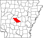
Saline County, Arkansas Basics:


Saline County Arkansas - Government Site

Population: 111,851
Area: 724 square miles
County seat: Benton
Area code(s) in use: 501
Time zone: CST
High school graduate or higher: 88.9%
Bachelor's degree or higher: 23.1%
Median household income: $53,817
Persons in poverty: 8.6%
Home ownership rate: 77.9%
Mean travel time to work: 25.2 minutes


Adjacent counties:
Garland  Grant  Hot Spring  Jefferson  Perry  Pulaski  
Find in Arkansas

Map of the Saline County area


Our detail map of Saline County shows the Saline County, Arkansas boundary lines and other interesting items.

Places in Saline County, Arkansas

  Airports     show all on map

Prides Airport, Saline County Regional Airport, Saline Memorial Hospital Heliport

  Areas     show all on map

Hickory Flats, Lake Winona Research Natural Area

  Bridges     show all on map

Ben Ball Bridge

  Buildings     show all on map

Alexander Human Development Center, Bauxite Police Department, Bauxite Volunteer Fire Department Station 1, Bauxite Volunteer Fire Station 2, Benton City Hall, Benton Fire Department Station 1, Benton Fire Department Station 2, Benton Fire Department Station 3, Benton Fire Department Station 4, Benton Police Department, Bryant Branch Saline County Public Library, Bryant City Hall, Bryant Fire and Rescue Station 3, Bryant Fire Department Station 1, Bryant Fire Department Station 2, Bryant Police Department, Collegeville Volunteer Fire Station, Crows Volunteer Fire Department, East End Volunteer Fire Department Station 1, East End Volunteer Fire Department Station 2, East End Volunteer Fire Department Station 3, Gann Museum, Haskell Fire Department, Haskell Fire Department Station 1, Haskell Police Department, Hot Springs Village Fire Department Cortez Station, Lake Norrell Volunteer Fire Department Station 1, Lake Norrell Volunteer Fire Department Station 2, Lonsdale Fire Department Station 2, Mauldin Fire Station, Metropolitan Emergency Medical Service East Bend, Northeast Volunteer Fire Department District 19 Station 1, Northeast Volunteer Fire Department District 19 Station 2, Paron Fire Station 1, Paron Fire Station 2, Salem Fire Department Station 1, Salem Fire Department Station 2, Salem Fire Department Station 3, Salem Fire Department Station 4, Saline County Courthouse, Saline County Public Library, Saline County Sheriff's Office, Sardis Volunteer Fire Department, Shannon Hills City Hall, Shannon Hills Police Department, Shannon Hills Volunteer Fire Department, Shaw Volunteer Fire Department, Springhill Volunteer Fire Department, Traskwood Volunteer Fire Station, Turtle Creek Volunteer Fire Department Station 1, Turtle Creek Volunteer Fire Department Station 2, Turtle Creek Volunteer Fire Department Station 3, Woodland Hills Volunteer Fire Department Station 1, Woodland Hills Volunteer Fire Department Station 2

  Cemeteries     show all on map

Alexander Cemetery, Bauxite Cemetery, Bolin Cemetery, Bryant Cemetery, Butler Cemetery, Cameron Cemetery, China Grove Cemeteries, Cold Spring Cemetery, Fairplay Cemetery, Forest Hills Memorial Park, Fowler Cemetery, Geurin Cemetery, Graham Cemetery, Hammonds Cemetery, Hicks Cemetery, Holly Cemetery, Hughes Cemetery, James Cemetery, Jay Cemetery, Langley Cemetery, Lee Cemetery, Liberty Cemetery, McPherson Cemetery, McPherson Cemetery, Moore Cemetery, Old Union Cemetery, Pine Crest Memorial Park, Pipkin Cemetery, Pleasant Grove Cemetery, Pleasant Hill Cemetery, Rose Garden Cemetery, Rosmont Cemetery, Salem Cemetery, Scott Cemetery, Slate Branch Cemetery, Social Hill Cemetery, Traskwood Cemetery, Upchurch Cemetery, Wesleys Chapel Cemetery, Winters Cemetery, Woodland Cemetery

  Census     show all on map

Avilla Census Designated Place, East End Census Designated Place, Hot Springs Village Census Designated Place, Salem Census Designated Place

  Churches     show all on map

Abundant Life Center Assembly of God Church, Antioch Church, Bethel Church, Bethel Missionary Baptist Church, Bivens Grove Church (historical), Bryant Church of Christ, Buffalo Church, Calvary Baptist Church, Calvary Church, Carmelite Novitiate, Cedar Grove Church, Collegeville Church of the Nazarene, Congo Road Baptist Church, Cross Road Church, Cross Roads Church, East End Church, East End Church, East Side Baptist Church, East Union Church, Emmanuel Church, Fairplay Baptist Church, Fairview Church, Faith Church, First Assembly of God Church, First Baptist Church, First Baptist Church, First Church, First Church of the Nazarene, First Lutheran Church, First Pentecostal Church, First Presbyterian Church, First Southern Baptist Church, First United Methodist Church, First United Methodist Church, Forest Hills Missionary Baptist Church, Foursquare Evangelical Church, Freedom Church, Grace Missionary Baptist Church, Grape Chapel, Gravel Hill Church, Guiding Light Church, Hester Chapel, Highland Heights Baptist Church, Hilldale Church, Holy Ridge Church, Hurricane Lake Church, Immanuel Church, Indian Springs Baptist Church, Kentucky Church, Lawson Church, Lorance Drive Church, Mars Hill Church, Mount Carmel Methodist Church, Mount Harmony Missionary Baptist Church, Mount Olive Church, Mount Vernon Baptist Church, Mount Zion Missionary Baptist Church, Mountain View Church, Mulberry Church, Mulberry Church, New Hope United Methodist Church, New Life Church, New Prospect Missionary Baptist Church, New Summit Church, Old Union Church, Olive Hill Church, Our Lady of Fatima Catholic Church, Parkview United Methodist Church, Plainview Church, Pleasant Hill African Methodist Episcopal Church, Pleasant Hill Baptist Church, Pleasant Hill Methodist Church, Pleasant Valley Church (historical), Ridgecrest Baptist Church, Saint Matthews Episcopal Church, Salem Baptist Church, Salem Church, Salem Church (historical), Salem Methodist Church, Sardis United Methodist Church, Sharon Missionary Baptist Church, Silica Heights Church (historical), Smyrna Church, Social Hill Missionary Baptist Church, Spring Creek Missionary Baptist Church, Spring Lake Church, Springhill Church, Ten Mile Missionary Baptist Church, Trinity Baptist Church, Trinity Church, United Missionary Baptist Church, Unity Landmark Church, Vimy Ridge Church, Vimy Ridge Church, Walnut Bottom Church, West Bauxite Missionary Baptist Church, Wildwood Church (historical), Wright Chapel, Zion Hill Church

  Crossings     show all on map

Daniels Ford, Interchange 106, Interchange 111, Interchange 114, Interchange 116, Interchange 117, Interchange 118, Interchange 121, Interchange 123, Nelson Ford, Smith Ford, Will James Ford

  Dams     show all on map

Barr Lake Dam, Bloomfield Lake Dam, Browns Lake Dam, Buffington Lake Dam, Caldwell Lake Dam, Cecil Jones Lake Dam, Chemical Products Fresh Water Lake Dam, Clearlake Dam, Congo Lake Dam, Crystal Lake Dam, Dawson Lake Dam, Ferguson Lake Dam, Fletcher Lake Dam, Hansen Lake Dam, Happy Valley Lake Dam, Helmich Lake Dam, Hester Lake Dam, Holding Pond Number 2 Dam, Hurricane Lake Dam, Inman Lake Number Two Dam, King Lake Dam, Lake Coronado Dam, Lake Krislor Dam, Lake Lago Dam, Lake New Moon Dam, Lake Norrell Dam, Lake Winona Dam, Ledbetter Lake Dam, Mary Lake Dam, Mashburn Lake Number One Dam, Mashburn Lake Number Two Dam, Mills Lake Dam, Old Brown Mud Lake Dam, Parker Lake Dam, Pathway Youth Camp Lake Dam, Pebble Lake Dam, Spring Lake Dam, Styres Lake Dam, Surge Pond Dam, Surge Pond Dam, Wise Lake Dam

  Hospitals     show all on map

Benton State Hospital, Rivendell Behavioral Health Services, Salasco Sanitarium (historical), Saline Memorial Hospital, Thomas McRae Tuberculosis Home

  Lakes     show all on map

Dotted Lake, Dotty Lake, Masoner Lake

  Locales     show all on map

Arkansas Childrens Colony McRae Unit, Benton Square Shopping Center, Camp Quapaw, Coronado Golf Course, Craigs Mill (historical), Eastern Star Club (historical), Ferguson Plaza Shopping Center, Lakeside Country Club, Lincoln Square Shopping Center, Longhills Golf Course, Military Plaza Shopping Center, Niloak Shopping Center, Saine County Fairgrounds, Shrine Club (historical), Spring Lake Club, Trace Creek Country Club

  Mines     show all on map

African Camp Mine, Alexander Hill Mine, Bertha Extension Mine, Bertha Mine, Bertha Underground Mine, Bizzell Mine, Bryant Mine, Canal Number 1 Mine, Canal Number 2 Mine, Cargill Mine, Cargill Mine, Cargill North Shaft Mine, Cargill South Shaft Mine, Childress Mine, Cleveland Mine, Cleveland Mine, Cleveland-Evans Mine, Covington Number 4 Mine, Covington Number 5 Mine, Davis Main Portal Mine, East Maud Mine, East Neilson Mine, East Ozark Mine, Ella Mine, Elrod Mine, Fletcher Mine, Fletcher-Hudspeth-Harris Mine, Gates Mine, Globe 28 Mine, Globe Mine, Granite Branch Mine, Gray East Pit Mine, Gray West Pit Mine, Hogue-Fletcher Mine, Hurricane Mine, Johnson New Pit Mine, Johnson Old Pit Mine, Julia Mine, Lantz Mine, Lone Seventh Mine, Maggie Mine, Martin Mine, Mary Mine, McDonald Mine, Middle Maud Mine, Midwest Mine, Mine 14, Neilson Mine, Norton Mine, Ozark 24 Mine, Ozark 28 Mine, Poodle Mine, Pruden Extension Mine, Pruden Mine, Quapaw North Pit Mine, Quapaw South Pit Mine, Ramsey Mine, Rowland Mine, Section 10 Mine, Section 14 East Pit Mine, Section 14 West Pit Mine, Section 15 Mine, Section 16 Mine, Section 17 Mine, Section 26 Mine, Section 28 Mine, Smith Mine, Southern Acid and Sulphur Mine, Spring Hill Mine, Standard Mine, Stringtown Mine, Stuckey Mine, Townsend Mine, Ulmer Mine, West Elrod Mine, West Maud Extension Mine, West Maud Mine, West Ozark Mine, Young Mine

  Parks     show all on map

Alum Creek Experimental Forest, Ashley Park, Bernard W Holland Park, Bryant Stadium, Lewis Stadium, Lyle Park, Tyndall Park, Wilbur Mills Park

  Populated Places     show all on map

Altharp (historical), Alum (historical), Avilla, Bauxite, Bauxite Junction, Benton, Bland, Blocher, Brooks, Brooks (historical), Bryant, Bryant Oaks, Careywood, Cold Springs (historical), Collegeville, Congo, Crows, Cunningham (historical), Curtis (historical), Detonti, Dirtdauber (historical), East End, Edgewood, Electric (historical), Evergreen, Fairplay (historical), Gibbons (historical), Goodman, Grape, Haskell, Hurricane (historical), Kentucky, Klondike (historical), Lakeside, Lena, Lignite, Nance, Opitz (historical), Owensville, Paron, Pine Haven, Raintree Acres, Reform, Richardson Place, Rubicon, Salem, Sardis, Shannon Hills, Shaw, Sherwood Estates, Slocomb (historical), Springhill, Tatumville (historical), Traskwood, Twin Oaks, Vimy Ridge, Whitlock (historical), Woodland (historical), Woodland Hills

  Post Offices     show all on map

Benton Post Office, Paron Post Office, Reform Post Office (historical)

  Reserves     show all on map

Flatside Wilderness

  Reservoirs     show all on map

4-H Camp Lake, Alcoa Water Supply, Barr Lake, Bloomfield Lake, Brown Lake, Buffington Lake, Caldwell Lake, Cecil Jones Lake, Clear Lake, Clearlake Reservoir, Crystal Lake, Dawson Lake, Ferguson Lake, Hansen Lake, Happy Valley Lake, Helmich Lake, Hester Lake, Hester Lake, Holding Pond Number Two Reservoir, Hurricane Lake, Indian Springs Lake, Inman Lake Number Two, King Lake, Lake Coronado, Lake Cortez, Lake Krislor, Lake Lago, Lake New Moon, Lake Norrell, Lake Pauline, Lake Winona, Ledbetter Lake, Maertins Lake, Mary Lake, Mashburn Lake Number One, Mashburn Lake Number Two, Old Brown Mud Lakes, Parker Lake, Pathway Youth Camp Lake, Pebble Lake, Spring Lake, Styres Lake, Surge Pond, Surge Pond, Timber Lake, Wise Lake

  Ridges     show all on map

Big Ridge, Cock Spurs, Prillman Ridge, White Oak Mountain

  Schools     show all on map

Angie Grant Elementary School, Avilla School (historical), Bauxite High School, Bennett School (historical), Benton High School, Benton Junior High School, Benton Middle School, Bryant Elementary School, Bryant High School, Bryant Junior High School (historical), Bryant Middle School, Caldwell Elementary School, Civitan School, Collegeville Elementary School, Congo School (historical), East End Elementary School, East End Intermediate School, East End School, East Side Junior High School, Fairview School (historical), Gray Hill School (historical), Harmony Grove High School, Harmony Grove Middle School, Howard Perrin Elementary School, Kentucky School (historical), Mount Olive School (historical), Mountain View School (historical), Mulberry School (historical), Notre Dame School, Paron Elementary School, Paron High School, Perrin Elementary School, Pine Haven Elementary School, Pleasant Hill School (historical), Prospect School (historical), Ringgold Elementary School, Robert L Davis Elementary School, Robert L Davis Elementary School, Rural Dale School, Salem Elementary School, Sardis School, Shaw School (historical), Siddell School (historical), Springhill Elementary School, State Youth Service Center, Viewpoint School (historical), West Side School, Westbrook Elementary School

  Springs     show all on map

Cold Spring

  Streams     show all on map

Allens Creek, Alum Fork Saline River, Big Branch, Big Branch, Big Branch, Big Creek, Bills Branch, Blue Branch, Boardtree Branch, Boot Creek, Bread Creek, Brier Lick Branch, Brushy Creek, Brushy Creek, Brushy Creek, Caney Creek, Caney Creek, Cave Creek, Chinquapin Creek, Clift Creek, Cold Spring Branch, Cove Creek, Cypress Creek, Depot Creek, Dobbs Creek, Dodson Creek, Dog Creek, Dotson Branch, Dry Branch, Dry Creek, Dry Creek, Dry Creek, Dry Lost Creek, Duck Creek, Emory Branch, Ferndale Creek, Gillis Branch, Haw Creek, Holly Creek, Holly Creek, Hopf Branch, Horsely Branch, Jay Creek, Kelly Branch, Lees Creek, Little Alum Fork, Little Hurricane Creek, Logan Creek, Love Creek, McCright Branch, McNeil Creek, Middle Fork Saline River, Mill Branch, Mill Creek, Mill Creek, Moccasin Creek, Moore Branch, Moren Branch, Mud Hole Branch, Muddy Branch, North Alum Creek, North Fork Saline River, Otter Creek, Owen Creek, Potter Creek, Red Bluff Branch, Rocky Branch, Salt Creek, Sanders Branch, Shockley Branch, South Alum Creek, South Fork Saline River, Spring Branch, Stillhouse Creek, Taylor Creek, Tenmile Creek, Thompson Branch, Trace Creek, Trace Creek, Treadway Branch, Turkey Creek, West Branch Cedar Creek, Wet Lost Creek, Williams Creek, Wolf Creek

  Summits     show all on map

Alexander Mountain, Angling Pinnacle, Beaver Pond Mountain, Bread Creek Pinnacle, Brushy Mountain, Cold Spring Mountain, Cole Mountain, Crystal Mountain, Crystal Mountain, Fall Mountain, Flat Mountain, Goosepond Mountain, Grindstone Mountain, High Point, Horseshoe Mountain, Howard Mountain, Jennings Mountain, Moss Mountain, Muse Mountain, Rattlesnake Mountain, Reform Point, Rody Mountain, Round Mountain, Schoolhouse Mountain, Wildcat Mountain, Wolf Pinnacle

  Towers     show all on map

KAKI-FM (Benton), KBBA-AM (Benton), KGKO-AM (Benton), KXIX-FM (Sheridan)

  Valleys     show all on map

Devils Hollow, Stillhouse Hollow,

Saline County, Arkansas Population By Race (2012 estimate)

RacePopulation
WhiteSaline County White population 102,344102,343  
BlackSaline County Black population 6,2646,263
MixedSaline County Mixed population 1,4541,454
AsianSaline County Asian population 1,0071,006
American IndianSaline County American Indian population 671671
Hawaiian & Pacific IslanderSaline County Hawaiian & Pacific Islander population 00

Additional population tables :
State population table
Arkansas population by county