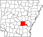
Jefferson County, Arkansas Basics:


Jefferson County Arkansas - Government Site

Population: 74,601
Area: 871 square miles
County seat: Pine Bluff
Area code(s) in use: 870 501
Time zone: CST
High school graduate or higher: 82.8%
Bachelor's degree or higher: 17.6%
Median household income: $37,561
Persons in poverty: 23.3%
Home ownership rate: 64.0%
Mean travel time to work: 21.4 minutes


Adjacent counties:
Arkansas  Cleveland  Grant  Lincoln  Lonoke  Prairie  Pulaski  Saline  
Find in Arkansas

Map of the Jefferson County area


Our detail map of Jefferson County shows the Jefferson County, Arkansas boundary lines and other interesting items.

Places in Jefferson County, Arkansas

  Airports     show all on map

Archer Landing Strip, Bennett Landing Strip, Grider Field Airport, Henderson Landing Strip, Jrmc Heliport, Smith's International Airport, Tommy's Flying Service Inc Airport, Wabbaseka Flying Service Airport

  Areas     show all on map

Sample Island, Silers Island

  Bars     show all on map

Brodie Bar (historical), Rob Roy Shoal

  Basins     show all on map

Bayou Narrow

  Bends     show all on map

Brodie Bend, Brodie Bend Cutoff, Cummins Bend, Hensley Bar Cutoff, Jack Bradley Bend, Lake Bend, Pastoria Bend, Richland Bend, Sainte Marie Bend, Trulock Bend, Williamette Bend (historical), Yell Bend

  Bridges     show all on map

Jefferson County Free Bridge, Rob Roy Bridge

  Buildings     show all on map

Altheimer Police Department, Altheimer Volunteer Fire Department, Arkansas Department of Corrections Maximum Security Unit, Arkansas Department of Corrections Randall L Walker Correctional Facility, Arkansas Department of Corrections Tucker Unit, Arkansas State Police Criminal Investigations Division Company B, Arkansas State Police Troop E, Emergency Ambulance Service, Federal Bureau of Investigation Pine Bluff Resident Office, Hardin Fire Department, Highway 15 Volunteer Fire Department, Island Harbor Volunteer Fire Department, Jefferson County Courthouse, Jefferson County Sheriff's Office, Linwood Moscow Volunteer Fire Department, Pine Bluff Arsenal, Pine Bluff Arsenal, Pine Bluff Convention Center, Pine Bluff Fire Department Station 1, Pine Bluff Fire Department Station 2, Pine Bluff Fire Department Station 3, Pine Bluff Fire Department Station 4, Pine Bluff Fire Department Station 5, Pine Bluff Fire Department Station 6, Pine Bluff Fire Department Station 7, Pine Bluff Police Department, Redfield Police Department, Redfield Volunteer Fire Department Station 1, Redfield Volunteer Fire Department Station 2, Redfield Volunteer Fire Department Station 3, Sherrill Volunteer Fire Department, Southeast Volunteer Fire Department, Tri - County Drug Task Force, Tucker Volunteer Fire Station, University of Arkansas / Pine Bluff Department of Public Safety, Wabbaseka Police Department, Wabbaseka Volunteer Fire Department, Watson Chapel Volunteer Fire Department, White Bluff Power Plant, White Hall Police Department, White Hall Volunteer Fire Department, Wright - Pastoria Volunteer Fire Department

  Canals     show all on map

Barraque Lateral, Black Bayou Lateral, Cross Ditch, Ditch A (historical), Lateral A-2, Lateral B, Lateral D-1, Lateral D-2, Lateral D-3, Lateral F, Lateral H, Lateral I, Lateral J, Lateral Number 1, Lateral Number 1, Lateral Number 2, Lateral Number 2, Lateral Number 2, Lateral Number 2, Lateral Number 2, Lateral Number 3, Lateral Number 4, Lateral Number 5, Lateral Number 5, Lateral Number 6, Lateral Number 7, Lateral Number 7, Lateral Number 8, Lateral Number 8, Lateral Number 9, Main Canal, Main Canal, Main Canal, Main Canal, Main Canal Number 9, Main Ditch, Main Ditch, Salt Bayou Drainage Ditch, Waterloo Drainage Ditch, Waterloo Drainage Ditch

  Capes     show all on map

Boyd Point, Cooper Point, Diamond Point, Fish Point (historical), Lake Point, Mocks Point

  Cemeteries     show all on map

Abbey Cemetery, Antioch Cemetery, Atkins Cemetery, Bellwood Cemetery, Bethel Cemetery, Blackman Cemetery, Blackwell Cemetery, Bloomy Shade Cemetery, Branch Cemetery, Brown Cemetery, Bryson Cemetery, Calvary Cemetery, Chandler Cemetery, Cheek Cemetery, Cherry Hill Cemetery, Clark Hill Cemetery, Cottondale Cemetery, Cottonwood Cemetery, Curl Cemetery, Damascus Cemetery, Douglas Cemetery, Elam Cemetery, Fairfield Cemetery, Fields Cemetery, Fitzhugh Cemetery, Forest Lawn Memorial Cemetery, Good Faith Cemetery, Graceland Cemetery, Greenlee Cemetery, Happy Home Cemetery, Hardin Cemetery, Heutt Cemetery, Hunters Cemetery, Jefferson Cemetery, Jefferson Cemetery, Jones Cemetery, Jones Cemetery, King Cemetery, Langford Cemetery, Lee Cemetery, Liberty Hill Cemetery, Macedonia Cemetery, Marzel Cemetery, McFadden Cemetery, Memorial Park Cemetery, Miller Cemetery, Morning Star Cemetery, Mound Bayou Cemetery, Mount Olive Cemetery, Mount Pleasant Cemetery, Mount Zion Cemetery, Mulberry Grove Cemetery, Musgrove Cemetery, New Gascony Cemetery, New Home Cemetery (historical), New Hope Cemetery, Nickelson Cemetery, Old Shiloh Cemetery, Patterson Cemetery, Philips Cemetery (historical), Phillips Cemetery, Piney Grove Cemetery, Piper Cemetery, Prayer Lake Cemetery, Red Bluff Cemetery, Redfield Cemetery, Rice Cemetery, Rose Lawn Memorial Garden, Ross Cemetery, Saint James Cemetery, Saint Josephs Cemetery, Saint Lukes Cemetery, Saint Marys Cemetery, Saint Paul Cemetery, Saint Peters Cemetery, Saint Ruth Cemetery, Saint Stephen Cemetery, Salem Cemetery, Smith Cemetery, Smith Chapel Cemetery, Spring Hill Cemetery, Taylor Cemetery, Thomas Cemetery, Tucker Cemetery, Turrentine Cemetery, Wabbaseka Cemetery, Walstein Cemetery (historical), Washington Cemetery, Watkins Cemetery, Watt Cemetery, Whites Cemetery

  Census     show all on map

Sulphur Springs Census Designated Place

  Channels     show all on map

Boyd Point Cutoff, McFadden Reach (historical), McGregor Reach (historical), Silers Chute (historical), Tar Camp Crossing, Wild Cat Crossing, Winfrey Reach

  Churches     show all on map

Antioch Church, Banks Chapel (historical), Barnes Chapel, Barnett Chapel, Barraque Baptist Church, Barrett Chapel Church (historical), Bass Chapel (historical), Bass Chapel Number 2 (historical), Battles Chapel, Bay Street Baptist Church, Belair Presbyterian Church, Belmont Church, Bethany Church, Bethel Church, Bethlehem Church (historical), Bethlehem Full Gospel Church, Bloomy Shade Church (historical), Breath of Life Church, Broadmoor Baptist Church, Broomfield Church (historical), Browns Chapel, Calvary Baptist Church, Cannan Missionary Baptist Church, Cannon Church, Carr Memorial United Methodist Church, Centennial Baptist Church, Central Baptist Church, Central Church, Central Presbyterian Church, Chapel Hill Church (historical), Cheek Church (historical), Cherry Hill Church (historical), Christian Church (historical), Christian Fellowship Missionary Baptist Church, Church of Christ, Church of Christ, Church of Christ, Coleman Chapel, College Heights Church of Christ, Corinth Church, Cottonwood Church, County Line Church, Damascus Church, Daniels Chapel, Double Wells Church, East Side Baptist Church, East Side Christian Church, Edgewood Baptist Church, Elam Church (historical), Elm Grove Church (historical), Eudora Church, Faith Cathedral, Faith Temple Church of God in Christ, Ferda Church, First Assembly of God Church, First Baptist Church, First Baptist Church of White Hall, First Christian Church, First Immanuel Missionary Baptist Church, First Missionary Baptist Church, First Pentecostal Church of God, First Presbyterian Church, First Trinity Church of God in Christ, First United Methodist Church, First United Pentecostal Church, Forrest Park Assembly of God Church, Forrest Park Baptist Church, Galilee Church (historical), Garden Springs Church, Gethsemane Church, Good Faith United Methodist Church, Grace Baptist Church, Grace Church, Greenlee Baptist Church, Hardin Baptist Church, Harmony Baptist Church, Harmony Church, Hazel Street Baptist Church, Highland Baptist Church, Hopewell Church, Immanuel Baptist Church, Indiana Street Baptist Church, Jefferson Church, Jerusalem Church, Jerusalem Church, Jerusalem Church (historical), Kings Highway Missionary Baptist Church, Kinnlen Star Church, Lake Dick Church (historical), Lakeside Chapel, Lakeside Church (historical), Lakeside United Methodist Church, Lamkin Chapel Missionary Baptist Church, Lemonwood Missionary Baptist Church, Liberty Hill Church, Linwood Baptist Church, Macedonia Church, Macedonia Church (historical), Main Street Church of God in Christ, Maranatha Baptist Church, Marzell Church, Matthews Memorial Baptist Church, Morning Star Church, Morning Star Church, Morris Chapel, Morrow Church, Motleys Chapel, Mound Bayou Church, Mount Calvary Baptist Church, Mount Ida Church (historical), Mount Moriah Church (historical), Mount Olive Church, Mount Pleasant African Methodist Episcopal Church, Mount Pleasant Church, Mount Zion Church, Mount Zion Church, Mount Zion Church, Mount Zion Church (historical), Mulberry Grove Church, Mulberry Grove Church (historical), New Bethlehem Church, New Bethlehem Church, New Home Church (historical), New Hope Christian Methodist Episcopal Church, New Hope Church, New Hope Church (historical), New Hope Church (historical), New Life Baptist Church, New Saint Hurricane Baptist Church, New Saint James Church (historical), New Shiloh Church, New Town Missionary Baptist Church, Northside Seventh Day Adventist Church, Oak Grove Baptist Church, Oak Grove Church, Oak Grove Church, Oak Park Church of the Nazarene, Oak Park Freewill Baptist Church, Oakland Church, Olive Branch Church, Olive Branch Church (historical), Olive Street Baptist Church, Owens Chapel (historical), Paradise Church, Parsons Hill Church, Pentecostal Church, Pilgrims Rest Church, Pilgrims Rest Church (historical), Pine Grove Church, Pine Hill Baptist Church, Pinecrest Baptist Church, Pleasant Grove Baptist Church, Pleasant Home Church, Plum Bayou Baptist Church, Plum Bayou Church (historical), Prayer Lake Church (historical), Providence Church, Redfield First Southern Baptist Church, Reydell Baptist Church, Reynolds Church, Rising Star Church (historical), River Road Church, Ronoke Church, Saint Andrews Church, Saint Andrews Church, Saint Bethel Baptist Church, Saint James Church, Saint James Church (historical), Saint James Church (historical), Saint James United Methodist Church, Saint John African Methodist Episcopal Church, Saint John Church, Saint Joseph Catholic Church, Saint Luke Church, Saint Lukes Baptist Church, Saint Lukes Church (historical), Saint Marks Church, Saint Marys Church, Saint Paul Baptist Church, Saint Pauls Church (historical), Saint Peters Catholic Church, Saint Peters Church (historical), Saint Peters Rock Baptist Church, Saint Raphaels Church, Saint Ruth Church (historical), Saint Stephen Church (historical), Salem Church, Second Baptist Church, Shady Grove Church, Shannon Road Baptist Church, Shell Chapel, Smith Chapel (historical), Southside Baptist Church, Spring Hill Church, Stewart Chapel, Sturgen Church (historical), Sulphur Springs Baptist Church, Sunrise Church, Tabernacle Church, Tabernacle Church of God in Christ, Taylor Chapel, Temple Anshe Emeth, Temple Star Church (historical), The Apostolic Church, The Church of Jesus Christ, Travelers Rest Church, Trinity Episcopal Church, Trinity Lutheran Church, Turner Church (historical), Turrentine Church (historical), Union Church, Union Grove Church (historical), Unity Church of Practical Christianity, Unity Missionary Baptist Church, Victory Baptist Church, Wabbaseka Church, Watkins Chapel, Watson Chapel Baptist Church, Wesley United Methodist Church, West Pine Bluff Church of God, Wheeler Chapel, White Hall United Methodist Church, Whiteville Church

  Cliffs     show all on map

Red Bluff, Tripletts Bluff, White Bluff, Yellow Bluff

  Crossings     show all on map

Brunson Crossing, Cummins Ferry (historical), Fergus Crossing, Greenback Ferry (historical), Jones Ferry (historical), Maddings Ferry (historical), Red Bluff Ferry (historical)

  Dams     show all on map

Arsenal Lake Dam, Camp Ta-Lo-Ha Lake Dam, Dike Number One Dam, Dike Number Two Dam, Hardin Lake Dam, Hardin Lake Dam Number Two, Jones Lake Dam, Lake Lee Dam, Lake Pine Bluff Dam, Lock and Dam Number 3, Lock and Dam Number 5, Lock and Dam Number Four, Marks Lake Dam, Midland Lake Dam, Neely Lake Dam, Oakley Lake Dam, Oakley Lake Number Two Dam, Phillips Lake Dam, Robinson Lake Dam, Rust Foundation Lake Number One Dam, Rust Foundation Lake Number Two Dam, Suburbia Lake Dam, Surge Pond Dam, Taliaferro Lake Dam, Tulley Lake Dam

  Flats     show all on map

Alexander Flat, Buckingham Flat, Sheppard Island

  Guts     show all on map

Bigham Bayou, Black Bayou, Boggy Slough, Bradley Slough, Cross Bayou, Fish Lake, Johnson Bayou, Mound Bayou, Short Bayou, Stillhouse Bayou

  Hospitals     show all on map

Arkansas Department of Correction-Diagnostic Unit, Jefferson Regional Medical Center

  Islands     show all on map

Cooper Island, Hensley Island, Kelly Island (historical)

  Lakes     show all on map

Atkins Lake, Barnett Lake, Big Grassy Brake, Big Grassy Lake (historical), Brean Lake, Brushy Lake, Brushy Lake (historical), Clear Pond, Dilly Pond, Dry Lake (historical), Dudley Lake, English Lake, Farelly Lake, Felix Pond, Five Forks Lake, Grassy Lake (historical), Hannaberry Lake, Horseshoe Lake, Horseshoe Pond, Imbeau Bayou, Johnson Lake, Johnson Lake, Lake Dick, Langford Lake, Mud Lake, Noble Lake, Old River Lake, Patton Lake, Puerto Rico Lake (historical), Reed Lake, Swan Lake, Tucker Lake (historical), Wilkins Lake, Willow Lake

  Levees     show all on map

Plum Bayou Levee

  Locales     show all on map

Adamsburg Landing, Bankhead Landing (historical), Broadmoor Shopping Center, Camelot Shopping Center, Camp Ta-Lo-Ha, Cedar Hill, Chapel Village Shopping Center, Cummins Landing (historical), Dexter Gate, Dumbeck Spur (historical), East Plaza Shopping Center, Eden Park Country Club, Greenleaf Landing, Jefferson Square Shopping Center, Leland Landing (historical), Magic Mart Shopping Center, National Center for Toxicological Research, Oak Park Village Shopping Center, Olive Street Plaza Shopping Center, Pine Bluff Country Club, Pine Bluff Disposal Landfill, Pine Bluff Port, Pines Mall Shopping Center, Plainview Gate, Reed Lake Spur (historical), Roan Landing (historical), Southeast Arkansas Livestock Showgrounds, Southwest Plaza Shopping Center, Stark Gate, Tracy Spur (historical), Tucker Prison Farm, Warbritton Gate, White Hall Shopping Center, Woodlawn Country Club

  Military     show all on map

Pine Bluff Arsenal

  Parks     show all on map

Bayou Meto Public Use Area, Belmont Park, Brump Bayou Park, Central Park, Hutson Park, Lake Pine Bluff Park, Little Bayou Meto Park, Lock, Lock and Dam Number 5 Public Use Area, Oakland Park, Pine Bluff Regional Park, Poplar Street Park, Rising Star Public Use Area, Sainte Marie Public Use Area, Sheppard Island Public Use Area, Tar Camp Public Use Area, Townsend Park, Trulock Public Use Area, White Hall City Park

  Populated Places     show all on map

Altheimer, Anrep (historical), Atkins Lake, Baldwin, Birmac, Bruce (historical), Clements (historical), College Park (historical), Cornerstone, Cottondale, Dexter, Diantha (historical), Dolton (historical), Donaldsonville, Double Wells, Doylestown, Eastwood, Ellison, Elmwood, English, English Place, Fairfield, Faith, Farelly Lake, Ferda, Gethsemane, Glenlake, Hannaberry, Hardin, Haywood, Henslee Heights, Hooker, Jefferson, Kearney, Kratnek (historical), Ladd, Lake Dick, Lake Farm, Lamb (historical), Lamberts (historical), Langford, Leitner, Linn (historical), Linwood, Madding, Midway, Moscow, New Gascony, Newtown, Noble Lake, Oakland Heights, Pastoria, Pine Bluff, Pinebergen, Plain View, Plum Bayou (historical), Ray Station (historical), Red Bluff (historical), Redfield, Reydell, Richardson, Rob Roy, Rone, Samples, Secrest (historical), Sherrill, Sorrells, Sulphur Springs, Swan Lake, Sweden, Tamo, Tucker, Wabbaseka, Waldstein (historical), Warbritton, Watson Chapel, West End, White Hall, Wilkins, Wright

  Post Offices     show all on map

Pine Bluff Post Office, Plum Bayou Post Office (historical), Waldstein Post Office (historical)

  Reservoirs     show all on map

Arsenal Lake, Clean Water Holding Pond, Clear Water Holding Pond, Hardin Lake, Hardin Lake Number Two, Jones Lake, Lake Langhofer, Lake Lee, Lake Pine Bluff, Marks Lake, Midland Lake, Neely Lake, Oakley Lake, Oakley Lake Number Two, Phillips Lake, Pool Five, Pool Four, Pool Three, Robinson Lake, Rust Lake Number One, Rust Lake Number Two, Shady Oaks Reservoir, Suburbia Lake, Surge Pond, Ta-Lo-Ha-Lake, Taliaferro Lake, Toney Lake (historical), Tulley Lake, Yell Lake (historical), Yellow Lake

  Schools     show all on map

34th Avenue Fine and Performing Arts Magnet School, Altheimer Middle School, Altheimer-Sherrill High School, Annunciation Academy, Antioch School (historical), Arkansas Industrial School, Arkansas Vocational-technical School, Arkansas Youth Services Center, Barnes School, Barrett Chapel School (historical), Barrett High School, Bass Chapel School (historical), Belair Elementary School, Bogey School (historical), Boyd School (historical), Broadmoor Elementary School, Broadmoor School, Burkes School (historical), Carver Elementary School, Coleman Elementary School, Coleman High School, Cottondale School (historical), Dial Junior High School, Dollarway High School, Dollarway Middle School, Dudley Lake School (historical), Edgewood Elementary School, Edmunds School, Eudora School, Faver School (historical), First Ward Elementary School, Five Forks School (historical), Five Points School (historical), Forrest Park Elementary School, Gabe Meyer Elementary School, Gandy Elementary School, Gethsemane School (historical), Gravel Hill School (historical), Greenville Elementary School, Hannaberry School, Hardin Elementary School, Haywood College (historical), Howard School (historical), Humphrey Elementary School, Humphrey High School, Indiana Street Elementary School, Jack Robey Junior High School, Jackman School (historical), James Metthews Elementary School, Jefferson Preparatory School, Jefferson School (historical), Jerusalem School (historical), Jessie R Core School (historical), L L Owen Elementary School, L L Owen Elementary School, Lakeside Elementary School, Lakeside School (historical), Lamberts School (historical), Linwood School (historical), Lockhart School (historical), Maranatha Christian School, Martin Elementary School, Martin High School, Matthews Elementary School, McClung School, Merrill High School, Moody Elementary School, Morris Chapel School (historical), Mosby School (historical), Mound Bayou School (historical), Mulberry Grove School (historical), Murphy School (historical), New Harmony School (historical), New Hope School (historical), New Life Christian School, Oak Grove School (historical), Oak Grove School (historical), Oak Park Elementary School, Oak Ridge School (historical), Pastoria School, Pastoria School (historical), Pine Bluff Christian School, Pine Bluff High School, Pine Bluff Junior High School, Pinecrest Elementary School, Plum Bayou School (historical), Redfield Junior High School, Rosenwald School (historical), Ruth School (historical), Saint Johns School (historical), Saint Lukes School (historical), Saint Marks School (historical), Saint Peters School, Sam Taylor Elementary School, Sherrill School, Shiloh School (historical), Silva School (historical), Sixth Avenue School, Southeast High School, Southeast Middle School, Southwood Elementary School, Star View School (historical), Sulphur Springs School, Sunrise School (historical), Sunshine School, Tabernacle School (historical), Taylor Elementary School, Taylors School (historical), Thirty-fourth Avenue Fine and Performing Arts Magnet School, Townsend Park North Elementary School, Townsend Park South Elementary School, Travelers Rest School (historical), Trinity School, Trinity School, Turrentine School (historical), University of Arkansas at Pine Bluff, Vaster School, W T Cheney Elementary School, Wabbaseka Elementary School, Wabbaseka High School, Walker High School, Walnut Grove School, Watkins School (historical), Watson Chapel High School, Watson Chapel Junior High School, White Hall High School, White Hall Junior High School, White Hall School, Wilkins School (historical), Woodrow Wilson Junior High School

  Streams     show all on map

Allgood Creek, Arnold Creek, Barnes Creek, Bayou Pete, Bear Bayou, Bear Bayou, Beaver Dam Bayou, Beaverdam Bayou, Black Bayou, Boggy Bayou, Boggy Bayou, Cane Creek, Caney Bayou, Caney Bayou Fork, Carver Mill Creek, Case Creek, Coon Bayou, Cousart Bayou, Craig Creek, Crooked Creek, Dale Creek, Davis Bayou, Dyson Creek, East Fork Derrieusseaux Creek, Eastwood Bayou, Five Forks Bayou, Flat Bayou, Gamble Creek, Harding Drain, Harris Bayou, Hudson Creek, Indian Woman Bayou, Jacks Bayou, Jackson Creek, King Bayou, Kings Bayou, Ledbetter Creek, Lipscomb Branch, Little Bayou Meto, Little Cypress Bayou, Long Pond Creek, Love Creek, McCalls Branch, Mile Branch, Mill Creek, Nevins Creek, Old Channel Plum Bayou, Phillips Creek, Plum Bayou, Riley Bayou, Rinehart Creek, Running Branch, Sandy Bayou, Schoolhouse Creek, Smith Creek, Smiths Bayou, Steep Bank Creek, Steep Bayou, Stokes Creek, Tar Camp Creek, Tulley Creek, Tupelo Bayou, Wabbaseka Bayou, Waterloo Bayou

  Summits     show all on map

Gum Springs Hill, Harris Mountains, Jennings Hill, Miller Hill, Sanders Hill

  Swamps     show all on map

Alice Brake, Glen Brake, Goose Lake, Grassy Lake, Grassy Lake, Haglers Cypress Brake, Harris Brake (historical), Little Grassy Brake, Reydell Brake, Round Cypress Brake, Shingle Mill Lake, Tupelo Brake (historical), Wash Lake

  Towers     show all on map

KATV-TV (Little Rock), KCAT-AM (Pine Bluff), KCLA-AM (Pine Bluff), KETS-TV (Little Rock), KIPR-FM (Pine Bluff), KOTN-AM (Pine Bluff), KPBA-AM (Pine Bluff), KPBQ-FM (Pine Bluff), KYDE-AM (Pine Bluff), KZYP-FM (Pine Bluff),

Jefferson County, Arkansas Population By Race (2012 estimate)

RacePopulation
BlackJefferson County Black population 41,32941,328  
WhiteJefferson County White population 31,33231,332
MixedJefferson County Mixed population 970969
AsianJefferson County Asian population 671671
American IndianJefferson County American Indian population 298298
Hawaiian & Pacific IslanderJefferson County Hawaiian & Pacific Islander population 7574

Additional population tables :
State population table
Arkansas population by county