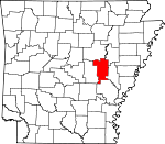
Prairie County, Arkansas Basics:


Prairie County Arkansas - Government Site

Population: 8,462
Area: 648 square miles
County seat: Des Arc
Area code(s) in use: 870
Time zone: CST
High school graduate or higher: 76.6%
Bachelor's degree or higher: 10.1%
Median household income: $35,806
Persons in poverty: 18.8%
Home ownership rate: 73.0%
Mean travel time to work: 25.0 minutes


Adjacent counties:
Arkansas  Jefferson  Lonoke  Monroe  White  Woodruff  

Find in Arkansas

Map of the Prairie County area


Our detail map of Prairie County shows the Prairie County, Arkansas boundary lines and other interesting items.

Places in Prairie County, Arkansas

  Airports     show all on map

Bob Norman Airstrip, Fowlkes Field, Greenwalt Company Airport, Hazen Heliport, Hazen Municipal Airport, Skarda/Tollville Airport, Stuttgart Municipal Airport, Taylor Airstrip

  Areas     show all on map

Lost Island

  Bays     show all on map

Peppers Eddy

  Bends     show all on map

Berden Slough Bend, Calhoun Bend, Coles Bend, Hicks Bend, Hider Bend, Hilderbrand Bend, McCrutchen Bend, Pecan Bend, Pumps Bend, Webb Lake Bend, Wilds Bend, Wolf Bend

  Bridges     show all on map

White River Bridge

  Buildings     show all on map

Biscoe Volunteer Fire Station, Brown Grove Volunteer Fire Department, Center Point Fire Department, Crossroads Volunteer Fire Department, De Valls Bluff Police Department, De Valls Bluff Volunteer Fire Department, Des Arc Ambulance Service, Des Arc Police Department, Des Arc Volunteer Fire Department, Hazen Police Department, Hazen Volunteer Fire Department, Northside Volunteer Fire Department, Oak Prairie Volunteer Fire Station, Peppers Lake Fire Department, Prairie County Courthouse, Prairie County Sheriff's Office, Sandhill Fire Station, Slovak Volunteer Fire Department, Southern Paramedic Service Hazen, Tollville Volunteer Fire Department, Ulm Fire Department

  Capes     show all on map

Dunns Shanty Point, Little Mill Point, Thomas Allen Point

  Cemeteries     show all on map

Belcher Cemetery, Biscoe Cemetery, Bryles Cemetery, Czech National Cemetery, Fairmount Cemetery, Ford Cemetery, Green Grove Cemetery, Harper Cemetery, Harris Cemetery, Hazen Cemetery, Hazen Cemetery, Johnson Chapel Cemetery, Kings Cemetery, Lakeside Cemetery, Lutheran Cemetery, McBee Cemetery, Mount Pleasant Cemetery, Oak Grove Cemetery, Oakland Cemetery, Old Bethel Cemetery, Pleasant Home Cemetery, Pleasant Ridge Cemetery, Powell Cemetery, Russian Orthodox Cemetery, Saint Luke Cemetery, Salem Cemetery, Tate Cemetery, Tucker Cemetery, Whippoorwill Cemetery, White Cemetery, Zion Cemetery

  Churches     show all on map

Abbington Church (historical), Center Point Church, Church of Christ, Cross Roads Church (historical), David Chapel, De Valls Bluff First Baptist Church, First Presbyterian Church, Friendship Church, Green Grove Church (historical), Hickory Plains Church, Hurricane Church, Johnson Chapel, Judson Memorial Church, Lakeside Church, McBy Church (historical), Morris Chapel, Morris Chapel (historical), Mount Pleasant Church (historical), New Bethel Church, Oak Prairie Church (historical), Old Hardshell Church, Peppers Lake Church, Philadelphia Church (historical), Pinch Church (historical), Pleasant Point Church (historical), Pleasant Ridge Church, Pleasant Ridge Church, Rogers Chapel (historical), Saint Pauls Church, Saint Peters Church, Union Chapel, Watson Church (historical), Welcome Home Church, Whippoorwill Church (historical), Zion Hill Church (historical)

  Cliffs     show all on map

Arkapola Bluff, Dicks Point, Fowler Point, Haleys Bluff, Kings Bluff, Smokehouse Bluff, White Bluff, Worshams Bluff

  Crossings     show all on map

Interchange 193, Interchange 202

  Dams     show all on map

Argo Reservoir Dam, Arkansas Noname 127 Dam, Arkansas Noname 131 Dam, Arkansas Noname 133 Dam, Arkansas Noname 149 Dam, Catfish Lake Dam, Crowley Lake Dam, Eddy Lake Dam, Hartz Reservoir Dam, Jerome Lake Dam, Joe Uhiren Reservoir Dam, Keathley Pond Dam, Lake Des Arc Dam, Lake Treadway Dam, Miers Lake Dam, Omni Corporation Pond Dam, Peckerwood Lake Dam, Strohl Reservoir Dam, Tates Reservoir Dam

  Flats     show all on map

Grand Prairie

  Guts     show all on map

Brushy Slough, Burnt Bayou, Fish Slough, Old River

  Islands     show all on map

Trimble Island

  Lakes     show all on map

Alligator Lake, Bean Lake, Belcher Lake, Big Brushy Lake, Big Twin Lake, Big Twin Lake, Black Lake, Blind Basin, Blue Hole, Blue Lake, Blue Lake, Bob Williams Lake, Cagles Eddy, Choctaw Lake, Clear Lake, Coitier Basin, Cooper Lake, Goose Basin, Goose Pond, Graveyard Slough, Halls Lake, Harvey Lake, Hendricks Lake, Hicks Lake, Hill Lake, Hodges Lake, Horn Lake, Horseshoe Lake, Horseshoe Lake, Horseshoe Lake, Jake Williams Lake, Keathley Pond, Lindermans Lake, Little Brushy Lake, Little Gum Pond, Little Lake, Little Twin Lake, Loggy Bayou, Maloy Lake, Miller Lake, Moores Lake, Old River Lake, Old River Lake, Peppers Lake, Roc Roe Lake, Round Basin, Round Lake, Slaughters Lake, Slippery Lake, Spring Lake, Straight Lake, The Basin, Twin Lakes, Twin Lakes, Tyler Lake, Upshaw Lake, Webb Lake

  Locales     show all on map

Audrich Switch, Center Point, Fairmount Station (historical), Fisher Landing, Lost Hill, Pankey Landing, Sandy Bank, Weeks Landing, Wilds Landing

  Military     show all on map

Stuttgart Army Air Field (historical)

  Parks     show all on map

Bayou Des Arc State Game Area, Holloway Memorial State Park, Wattensaw State Game Area

  Populated Places     show all on map

Balle (historical), Bardill (historical), Barrettsville, Bay Plantation, Beecher (historical), Beulah, Biscoe, Brasfield, Bucks Landing, Childers, Crossroad, Cuneo (historical), De Valls Bluff, Des Arc, Edwards, Enarc (historical), Erwin, Fairmount, Fourmile Corner, Gospoda, Hallsville, Harrys, Harrys (historical), Hayley, Hazen, Hickory Plains, Hunterton (historical), Jasmine, Kay, La Grue (historical), Leighton (historical), Letchworth, Mesa, Mooresville (historical), Nahay (historical), Peppers Lake, Peppers Landing, Plunketts, Sand Hill, Screeton, Siedenstricker, Slovak, Slovaktown (historical), Spear (historical), Stineville (historical), Tarnceville, Thomas (historical), Thurman, Tollville, Ulm, Uzzett (historical), Vaby, Veits (historical), Willard (historical), Yuma (historical)

  Post Offices     show all on map

Stineville Post Office (historical)

  Reserves     show all on map

Smoke Hole Natural Area

  Reservoirs     show all on map

Aker Reservoir, Argo Reservoir, Catfish Lake, Crowley Lake, Eddy Lake, Floyds Reservoir, Frakers Reservoir, Hansons Reservoir, Hartz Reservoir, Holloway Pond, Jerome Lake, Joe Uhiren Reservoir, Lake Des Arc, Lake Treadway, Lost Island Reservoir, Menett Reservoir, Miers Lake, Newkirks Reservoir Number 1, Newkirks Reservoir Number 2, Novak Reservoir, Omni Pond, Peckerwood Lake, Sims Reservoir, Stroh Reservoir, Tates Reservoir, Taylor Pond, Thomas Reservoir Number 2, Vaughts Reservoir, Whiskey Creek Reservoir, Wing Meade Reservoir, Wolf Reservoir

  Ridges     show all on map

Pfennighausen Ridge, Upper Surrounded Hill, White Oak Ridge

  Schools     show all on map

Anderson School (historical), Barretsville School (historical), Brown Grove School (historical), Center Point School (historical), Cross Roads School (historical), Cuneo School (historical), Des Arc Elementary School, Des Arc High School, DeValls Bluff Elementary School, DeValls Bluff High School, Fairmount School (historical), Fisher School (historical), Hazen Elementary School, Hazen High School, Hickory Plains School, Hickory Plains School (historical), Hodges School (historical), Holloway School (historical), Independence School (historical), Johnson Chapel School (historical), Kreger School (historical), New Bethel School (historical), Oak Prairie School (historical), Peters School (historical), Pinch School (historical), Plainview School (historical), Pleasant Point School (historical), Pontiac School (historical), Rogers School (historical), Skorda School (historical), Thurman School, Tittler School (historical), Wylie School (historical), Zion Hill School (historical), Zion School (historical)

  Streams     show all on map

Bane Creek, Barkley Branch, Barnes Creek, Bayou Des Arc, Bayou Two Prairie, Bear Creek, Bear Slough, Beaver Bayou, Bell Branch, Biene Creek, Big Creek, Blue Lake Slough, Brownings Branch, Buck Branch, Buck Creek, Clark Creek, Clearpoint Creek, Culotches Bay Slough, Darst Branch, Dunn Creek, Faras Run, Hickory Plains Creek, Hill Bayou, Honey Creek, Hughes Slough, Hurricane Creek, Johnson Branch, Lasses Creek, Lick Creek, Little Faras Run, Little Hurricane Creek, Long Branch, Lost Island Bayou, Maloy Bayou, Mellon Branch, Miller Creek, Mitchell Branch, Oak Creek, Overflow Branch, Pate Branch, Payne Creek, Powell Creek, Raft Creek, Sherril Creek, Short Creek, Snipe Creek, South Branch LaGrue Bayou, South Fork Little Hurricane Creek, Tubbs Creek, Washington Creek, Wattensaw Bayou, Webb Branch, Whippoorwill Creek, Whisky Creek, White Creek, Wolf Island Slash

  Summits     show all on map

Big Greenbrier Hill, Little Greenbrier Hill, Little Hill, Lost Hill, Sand Hill

  Swamps     show all on map

Big Gum Pond (historical), Crosslay Slough, Cypress Swamp, Little Twin Lake, Mud Lake, Rayburn Brake, Sholden Pond

  Towers     show all on map

KABK-FM (Augusta), KXRC-FM (Clarendon),

Prairie County, Arkansas Population By Race (2012 estimate)

RacePopulation
WhitePrairie County White population 7,2947,294  
BlackPrairie County Black population 1,0581,057
MixedPrairie County Mixed population 6867
American IndianPrairie County American Indian population 3433
AsianPrairie County Asian population 88
Hawaiian & Pacific IslanderPrairie County Hawaiian & Pacific Islander population 00

Additional population tables :
State population table
Arkansas population by county