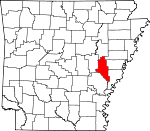
Monroe County, Arkansas Basics:
Monroe County Arkansas - Government Site
Population: 7,854
Area: 607 square miles
County seat: Clarendon
Area code(s) in use: 870
Time zone: CST
High school graduate or higher: 73.4%
Bachelor's degree or higher: 12.9%
Median household income: $28,075
Persons in poverty: 26.6%
Home ownership rate: 62.8%
Mean travel time to work: 19.1 minutes
Adjacent counties:
Arkansas Lee Phillips Prairie St. Francis Woodruff
Places in Monroe County, Arkansas
Clarendon Municipal Airport,
Frank Federer Memorial Airport,
Holly Grove Municipal Airport Jones Island Crooked Point Cut-off,
Holly Tree Bend,
Hurricane Bend,
Ninety Point 1st Judicial District Drug Task Force,
Arkansas Game and Fish Commission Law Enforcement East Central Regional Office,
Brinkley City Hall,
Brinkley Fire Department,
Brinkley Police Department,
Clarendon Police Department,
Clarendon Volunteer Fire Department,
East Monroe County Rural Fire Department Station 1,
East Monroe County Rural Fire Department Station 2,
Folsom Memorial Library,
Holly Grove Fire Department,
Holly Grove Police Department,
Maddox Bay Volunteer Fire Department,
Monroe County Sheriff's Office,
Roc Roe Volunteer Fire Department,
Southern Paramedic Service Brinkley Big Eddy Point,
Coahoma Point,
Dead Man Point,
Franklin Point,
Sycamore Point Anderson Cemetery,
Ash Grove Cemetery,
Bateman Cemetery,
Calvary Cemetery,
Carr Cemetery,
Choctaw Cemetery,
Connells Cemetery,
Dyer Cemetery,
Finell Cemetery,
Fitzhugh Cemetery,
Franks Cemetery,
Goodwin Cemetery,
Haven Rest Cemetery,
Henard Cemetery,
Israel Cemetery,
Jordan Cemetery,
Macedonia Cemetery,
Macedonia Cemetery,
Mount Zion Cemetery,
Munn Cemetery,
Oaklawn Cemetery,
Philadelphia Cemetery,
Pine Ridge Cemetery,
Pine Ridge Cemetery,
Pleasant Valley Cemetery,
Redmans Cemetery,
Roc Roe Cemetery,
Saint John Cemetery,
Saint John Cemetery,
Saint Paul Cemetery,
Shady Grove Cemetery,
Shiloh Cemetery,
Smalley Cemetery,
Travelers Rest Cemetery,
Union Cemetery,
Upper Cemetery,
Valley Grove Cemetery Beauty Spot Church (historical),
Bethlehem Church,
Bethlehem Church,
Bethlehem Church,
Big Star Church,
Branch Church,
Bright Light Church (historical),
Brinkley Missionary Baptist Church,
Broadmoor Baptist Church,
Church of Christ,
Dyer Church,
Faith Missionary Baptist Church,
Faith Temple Church of God in Christ,
First Assembly of God Church,
First Baptist Church,
First Baptist Church,
First Presbyterian Church,
First Saint John Church (historical),
First United Methodist Church,
Full Gospel Church of God,
Gethsemane Baptist Church,
Grove Church,
Heartline Fellowship Church,
Jeffries Church (historical),
Lawrenceville Church,
Monroe Baptist Church,
Mount Canaan Church,
Mount Carmel Church,
Mount Olive Church,
Mount Olive Missionary Baptist Church,
Mount Pleasant Church,
Mount Pleasant Church,
Mount Zion Baptist Church,
Mount Zion Church,
New Home Church (historical),
New Hope Church,
Oak Grove Church,
Our Savior Church,
Park Grove Church,
Philadelphia Church,
Philadelphia Church (historical),
Pine Hill Church,
Pine Ridge Church,
Pleasant Valley Church,
Saint James Church (historical),
Saint John Church,
Saint John the Baptist Catholic Church,
Saint Johns Missionary Baptist Church,
Saint Luke Church,
Saint Lukes Episcopal Church,
Saint Matthew Church,
Saint Paul African Methodist Episcopal Church,
Saint Paul Church,
Saint Paul Missionary Baptist Church,
Shiloh Church,
Shiloh Church,
Tabernacle of Victory Church,
Tyree Church,
Valley Grove Church,
Wheatley Chapel Interchange 216 Carnes Lake Dam,
Cruthis Lake Dam,
Lake Greenlee Reservoir Dam,
McCollum Lake Dam,
Midway Lake Dam,
Water Bayou Dam Adams Bayou,
Ash Slash,
Bear Camp Slough,
Channey Slough,
Cut Bluff Slough,
Fish Lake Slough,
Maloy Bayou,
Maple Slough,
Maple Slough,
Middle Prong,
Mud Slough,
Reeses Fork,
Right Hand Prong,
The Horn Delta Medical Center (historical) Barnes Lake,
Bear Slough,
Beaver Dam Lake,
Bellknap Lake,
Big Baptize Lake,
Big Cotton Lake,
Big Eagle Lake,
Big Weidmann Lake,
Blue Hole,
Boggy Lake,
Browns Shanty Lake,
Brushy Lake,
Brushy Lake,
Brushy Lake,
Buck Lake,
Bull Lake,
Burnt Cypress Lake,
Clear Lake,
Cloud Lake,
Cooter Lake,
Crab Lake,
Crosspond Bayou,
Crowfoot Lake,
Dodson Lake,
Eagle Nest Lake,
Eagle Nest Lake,
East Lake,
First Old River,
Fish Lake,
Forked Lake,
Goose Lake,
Goose Lake,
Goose Lake,
Goose Lakes,
Goose Pond,
Graveyard Lake,
Green Lake,
Hart Lake,
Heifer Lake,
Hickson Lake,
Hog Thief Lake,
Hole in the Wall,
Horseshoe Lake,
Horseshoe Lake,
Horseshoe Lake,
Ingram Lake,
Kansas Lake,
Lambert Bayou,
Little Baptize Lake,
Little Cotton Lake,
Little Eagle Lake,
Little Long Lake,
Little Moon Lake,
Little Weidmann Lake,
Long Lake,
Long Lake,
Lost Lake,
Lower Crooked Lake,
Lower Eagle Nest Lake,
Lower Forked Lake,
Middle Crooked Lake,
Middle Old River,
Mill Lake,
Moon Lake,
Mud Lake,
Mud Lake,
Mule Lake,
Otter Lake,
Passmore Lake,
Pryor Lake,
Rainbow Lake,
Red Cat Lake,
Round Lake,
Round Pond,
Round Pond,
Sandy Slough,
Section 16 Lake,
Simpson Lake,
Straight Lake,
Straight Lake,
Upper Crooked Lake,
Upper Eagle Nest Lake,
Upper Forked Lake,
Upper Hooked Lake,
Upper Old River,
Upper Swan Lake,
Waters Bayou,
White Oak Lake,
Willow Lake,
Wire Lake Lambrook Levee Ashford Landing,
Brinkley Country Club,
Dillard Landing,
Dunn's Fish Farm,
Lambert Landing,
Pine Crest Shopping Center,
Ramsey Mill Site Brinkley City Park,
Dagmar State Wildlife Management Area,
Greenlee Park,
White River National Wildlife Refuge Aberdeen,
Alfrey,
Allendale,
Bayless,
Blackton,
Brinkley,
Burma (historical),
Clarendon,
Connells Point,
Cowpens (historical),
Creigh,
Cross Roads,
Dagmar,
Deep Elm,
Dobbs Landing,
Duncan,
Eden,
Emmons,
Fargo,
Holly Grove,
Indian Bay,
Jeffries,
Keevil,
Lawrenceville,
Lenoir (historical),
Mayos,
Monroe,
Palmer,
Park Grove,
Perman (historical),
Pine City,
Ragtown,
Raymond (historical),
Rich,
Roe,
Saulsburg,
Smale,
Stoops (historical),
Towle (historical),
Zent Aberdeen Post Office (historical), Baytown Post Office (historical), Blackton Post Office (historical), Blakley Post Office (historical),
Brinkley Post Office, Clarendon Post Office, Cypress Ridge Post Office (historical), Duncan Post Office (historical),
Fargo Post Office (historical), Heflin Post Office (historical), Holly Grove Post Office, Indian Bay Post Office (historical), Jacobs Staff Post Office (historical), Kanola Post Office (historical), Keevil Post Office (historical), Lamberton Post Office (historical), Lawrenceville Post Office (historical), Lightle Post Office (historical), Lynchville Post Office (historical),
Monroe Post Office, Oaklawn Post Office (historical), Odoms Post Office (historical), Palmer Post Office (historical), Pine City Post Office (historical), Pine Grove Post Office (historical), Pine Ridge Post Office (historical), Pleasant Lake Post Office (historical), Raymond Post Office (historical), Reagans Bluff Post Office (historical), Rich Post Office (historical), Roc Roe Post Office (historical), Saulsburg Post Office (historical), Sebastian Post Office (historical), Valley Grove Post Office (historical), Waldrop Post Office (historical), Zent Post Office (historical)
Brinkley Lake,
Caney Slash,
Carnes Lake,
Cruthis Lake,
Lake Greenlee,
Lake Greenlee Reservoir,
McCollum Lake,
Midway Lake,
Water Bayou Reservoir Walnut Ridge Beauty Spot School (historical),
Brinkley High School,
Brinkley Middle School,
C B Partee Elementary School,
Clarendon Elementary School,
Clarendon High School,
Holly Grove Elementary School,
Holly Grove High School,
Monroe Academy,
Mount Pleasant School (historical),
New Hope School (historical),
Pine Ridge School (historical),
Tyree School (historical),
Valley Grove School (historical) Bayou De View,
Benson Slash Creek,
Big Creek,
Big Slash,
Boat Gunwale Slash,
Cache River,
Caney Creek,
Coon Tail Creek,
Dawson Slough,
Dial Creek,
East Bayou,
Elm Slough,
Fish Slough,
Givins Branch,
Green Bayou,
Hill Bayou,
Indian Bay,
Indian Bayou,
Jackson Bayou,
Jacobs Slash,
Knights Creek,
Little Robe Bayou,
Locust Creek,
Maddox Bay,
Mill Bayou,
Neicy Slash,
Prairie Cypress Creek,
Roc Roe Bayou,
Sandy Bayou,
Sevenmile Bayou,
Turkey Creek,
Twin Slough,
Walker Cypress Creek Big Robe Bayou,
McFarland Brake KBRI-AM (Brinkley),
KQMC-FM (Brinkley),

