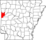
Sebastian County, Arkansas Basics:


Sebastian County Arkansas - Government Site

Population: 127,404
Area: 532 square miles
County seat: Fort Smith
Area code(s) in use: 479
Time zone: CST
High school graduate or higher: 82.4%
Bachelor's degree or higher: 18.7%
Median household income: $40,247
Persons in poverty: 20.5%
Home ownership rate: 63.9%
Mean travel time to work: 17.6 minutes


Adjacent counties:
Crawford  Franklin  Le Flore (OK)  Logan  Scott  Sequoyah (OK)  
Find in Arkansas

Map of the Sebastian County area


Our detail map of Sebastian County shows the Sebastian County, Arkansas boundary lines and other interesting items.

Places in Sebastian County, Arkansas

  Airports     show all on map

Arrowhead Assault Strip, Flying W Air Park Inc, Fort Chaffee Landing Strip, Fort Smith Municipal Airport, Saint Edward Mercy Medical Center Heliport, South Fort Smith Municipal Airport, Sparks Regional Medical Center Heliport

  Bridges     show all on map

Byrns Bridge, Jenny Lind Bridge, Milltown Bridge

  Buildings     show all on map

12th Judicial District Drug Task Force, 188th Fighter Wing Air National Guard Security Squadron, Arkansas Game and Fish Commission Law Enforcement Fort Smith Regional Office, Arkansas State Police Troop H, Barling City Hall, Barling Police Department, Barling Volunteer Fire Department, Big Creek Fire Department Station 1, Big Creek Fire Department Station 2, Bonanza Fire Station, Bonanza Police Department, Bureau of Alcohol, Tobacco, And Firearms - Fort Smith, Central City Fire Station, Central City Police Department, Community Rescue Mission, E S Stephens Boys Club, Evans Boys Club, Excelsior/ Mount Zion / Palestine Rural Fire Department, Federal Bureau of Investigation, Fort Chaffee Police Department, Fort Smith Art Center, Fort Smith City Hall, Fort Smith Emergency Medical Service, Fort Smith Fire Department Station 1, Fort Smith Fire Department Station 10, Fort Smith Fire Department Station 2, Fort Smith Fire Department Station 3, Fort Smith Fire Department Station 4, Fort Smith Fire Department Station 5, Fort Smith Fire Department Station 6, Fort Smith Fire Department Station 7, Fort Smith Fire Department Station 8, Fort Smith Fire Department Station 9, Fort Smith Girls Club, Fort Smith Inter-Faith Community Center, Fort Smith Municipal Auditorium, Fort Smith Museum of History, Fort Smith Police Department, Fort Smith Public Library, Fort Smith Trolly Museum, Greenwood Police Department, Greenwood Rural Fire Department, Greenwood Volunteer Fire Department, Hackett Police Department, Hackett Volunteer Fire Department, Hartford Police Department, Hartford Volunteer Fire Department, Huntington Police Department, Huntington Volunteer Fire Department, Immigration Customs Enforcement, Jenny Lind Fire Department, Lavaca Fire and Rescue, Lavaca Fire and Rescue Ambulance, Lavaca Police Department, Mansfield Fire Station, Midland Fire Station, Milltown Washburn Fire Department Station 2, Milltown Washburn Fire Station, Nancy Orr Girls Club, Northside Branch Fort Smith Public Library, Northside Community Center, Patent Model Museum, Provost Marshal Office Fort Chaffee, R C Mallalieu Community Center, Riverdale Fire Station, Saint Johns Community Center for the Elderly, Sebastian County Courthouse, Sebastian County Courthouse, Sebastian County Emergency Medical Services Greenwood, Sebastian County Sheriff's Office, Sebastian County Sheriff's Office Greenwood District, Sugarloaf - Slaytonville Fire Station, United States Drug Enforcement Administration - Fort Smith, United States Marshal Service - Fort Smith, University of Arkansas Fort Smith Police Department, Vista Health Fort Smith, West Arkansas Gym, White Bluff - Rye Hill Fire Department Station A, White Bluff - Rye Hill Fire Department Station B

  Capes     show all on map

Belle Point

  Cemeteries     show all on map

Arbuckle Cemetery, Barling Cemetery, Begum Cemetery, Bell Cemetery, Bethel Cemetery, Buggy Hill Cemetery, Bull Cemetery, Calvary Cemetery, Carnis Auburn Road Cemetery, Carruth Cemetery, Carter Cemetery, Center Valley Cemetery, Cherokee Cemetery, Clark Cemetery, Clarkeen Cemetery, Dake Cemetery, Dawson Memorial Cemetery, Doubleday Cemetery, Douglass Cemetery, Forest Park Cemetery, Fort Smith National Cemetery, Gentry Cemetery, Gilliam Cemetery, Greenwood Cemetery, Hartford Memorial Cemetery, Hepseby Cemetery, Hickory Ridge Cemetery, Hill Cemetery, Holy Cross Cemetery, Huntington Cemetery, Inoian Cemetery, Island Cemetery, James Fork Cemetery, Jones Cemetery, Killings Cemetery, Laura A Nolan Cemetery, Lewis Cemetery, Liberty Cemetery, Lone Star Cemetery, Lovelace Cemetery, Mannuis Cemetery, Marietta Cemetery, Mayberry Cemetery, Mc Allister Cemetery, Mc Connel Cemetery, Mc Coy Cemetery, Measles Memorial Cemetery, Memorial Cemetery, Morris Cemetery, Morrow Cemetery, Mount Olive Cemetery, Mount View Cemetery, Mount Zineche Cemetery, Newlon Cemetery, Oak Cemetery, Oak Valley Cemetery, Old Hickory Cemetery, Old Union Cemetery, Pleasant Hill Cemetery, Pleasant Ridge Cemetery, Pleasant Valley Cemetery, Ramsey Cemetery, Red Oak Cemetery, Red Yard Cemetery, Rose Lawn Cemetery, Saint Marys Cemetery, Speegle Cemetery, Steep Hill Cemetery, Stone Cemetery, Stroud Cemetery, Union Ridge Cemetery, Vaenita Cemetery, Valley View Cemetery, Ward Cemetery, Washburn Cemetery, Washington Cemetery, White and Shelby Cemetery, White Bluff Cemetery, William Teague Cemetery, William Teague Cemetery, Wisely Cemetery

  Channels     show all on map

Arbuckle Island Cutoff

  Churches     show all on map

Albert Pike Christian Church, Amity Church, Apostolic Faith Church, Bethel Church, Bethel Lutheran Church, Bloomer Baptist Church, Bluff Avenue Baptist Church, Burnville Baptist Church, Calvary Apostolic Pentecostal Church, Calvary Assembly of God Church, Calvary Baptist Church, Campbell Chapel African Methodist Episcopal Church, Cavanaugh Baptist Church, Cavanaugh Freewill Baptist Church, Cavanaugh United Methodist Church, Central Assembly of God Church, Central Baptist Church, Central Church, Central Presbyterian Church, Christ the King Church, Church of Christ, Church of Christ, Church of Christ, Church of Christ, Church of God, Church of God of Prophecy, Church of God of the Union Assembly, Church of the Living God, Clarks Chapel, Cliff Terrace Assembly of God Church, Colony South Baptist Church, East Side Baptist Church, Evangelical Temple Assembly of God Church, Excelsior Baptist Church, Faith Assembly of God Church, Faith Baptist Church, Faith Chapel Church, Faith Freewill Baptist Church, Fiftieth Street Church of Christ, First Baptist Church, First Baptist Church of Greenwood, First Baptist Church of Lavaca, First Christian Church, First Church of Christ Scientist, First Church of God, First Church of God, First Church of God in Christ, First Church of the Nazarene, First Cumberland Presbyterian Church, First Freewill Baptist Church, First Lutheran Church, First Pentecostal Church of God, First Presbyterian Church, First United Methodist Church, Fort Smith Bible Fellowship Church, Full Gospel Lighthouse, Glad Tidings Church, Goddard United Methodist Church, Good News Assembly of God Church, Grace Temple Baptist Church, Grand Avenue Baptist Church, Harvest Time Tabernacle, Haven Heights Baptist Church, Henderson Holy Temple, Heritage Baptist Church, Highway 96 Baptist Church, Homestead Heights Baptist Church, Howard Hill Church, Immaculate Conception Catholic Church, Immanuel Baptist Church, Jackson Street Church of God, James Fork Church, Jenny Lind Baptist Church, King Solomon Missionary Baptist Church, Kingdom Hall, Kingdom Hall of Jehovahs Witnesses, Kingdom Hall of Jehovahs Witnesses, Lighthouse Baptist Church, Loves Chapel Seventh Day Adventist Church, Mallalieu United Methodist Church, Maranatha Fellowship Church, Masojid Religious Worship Temple, Massard Baptist Church, Massard United Methodist Church, Midland Heights United Methodist Church, Milltown Church, Miracle Power Tabernacle, Mission Point Baptist Church, Mount Harmony Baptist Church, Mount Moriah Baptist Church, Mount Zion Baptist Church, Mount Zion Methodist Church, Negro Hill Church, New Apostolic Church, New Bethel Assembly of God Church, New Hope Baptist Church, New Providence Church, Ninth Street Baptist Church, Ninth Street Church of Christ, North Side Baptist Church, Northside United Pentecostal Church, Oak Cliff Baptist Church, Old Town Church, Old Union Church, Our Redemmer Lutheran Church, Palestine Baptist Church, Park Hill Church of Christ, Pentecostal Church of God, Pentecostal Holiness Church, Pentecostal House of Righteousness, Phdminh Buddist Temple, Phoenix Village Baptist Church, Pine Grove Church, Pleasant Hill Church, Primera Iglesia Hispana Batista, Quinn Chapel African Methodist Episcopal Church, Reorganized Church of Jesus Christ of Latter Day Saints, Revival Center, River of Life Chapel Pentecostal Church of God, Riverdale Church, Rye Hill Baptist Church, Saint Andrew United Methodist Church, Saint Augustines Episcopal Church, Saint Bartholomews Episcopal Church, Saint Boniface Catholic Church, Saint James Missionary Baptist Church, Saint Johns Episcopal Church, Saint Luke Lutheran Church, Saint Marys Church, Saint Paul United Methodist Church, Seventh Day Church of God, Shiloh Baptist Church, Shiloh Church, South Fort Smith Freewill Baptist Church, South Side Baptist Church, Southside Assembly of God Church, Southside Christian Church, Southside Church of God, Southside Nazarene Church, Spradling Baptist Church, Streams in the Desert Ministries, Temple Baptist Church, Trinity Baptist Church, Trinity Church of the Nazarene, Trinity Holiness Church, Trinity Temple, Union Church, Unity Church, Unity Missionary Baptist Church, Valley View Church, Victory Chapel, Victory Temple, Vietnamese Baptist Church, Walnut Street Freewill Baptist Church, Way of Life Pentecostal Church, Wesley United Methodist Church, West Arkansas Church, West Harmony Church, Westark Baptist Student Center, Westark Church of Christ, Westark Methodist Student Center, Westminster Presbyterian Church, Wheeler Avenue Church of Christ, White Bluff Church, Windsor Park Baptist Church, Word of Faith Tabernacle, Wyatt Memorial United Methodist Church

  Cliffs     show all on map

Big Creek Narrows

  Crossings     show all on map

Interchange 10, Interchange 11, Interchange 12, Interchange 13, Interchange 14, Interchange 5, Interchange 6, Interchange 8, Interchange 9

  Dams     show all on map

Arkansas Noname 212 Dam, Crain Lake Dam, Crouch Pond Number Two Dam, Echols Lake Dam, Engineer Lake Dam, Greenwood Reservoir Dam, Johnny Cake Lake Number One Dam, Johnny Cake Lake Number Two Dam, Kimmons Lake Dam, Lake Spur Dam, Lock and Dam Number 13, Mansfield Dam, McMahan Lake Dam, Park Lake Dam, Sebastian Lake Dam, Shadow Lake Dam, Sugar Loaf Lake Dam, Wildcat Mountain Lake Dam, Williamson Lake Dam, Willies Lake Dam

  Gaps     show all on map

Bradshaw Narrows

  Hospitals     show all on map

Advance Care Hospital Fort Smith, Cooper Clinic, Harbor View Mercy Hospital, HealthSouth Rehabilitation Hospital Fort Smith, Holt Krock Clinic, Labahn Veterinary Hospital, Saint Edward Mercy Medical Center, Select Specialty Hospital Fort Smith, Sparks Regional Medical Center, Tuberculosis Sanitorium, Twin City Hospital, Waldron Place Medical Center

  Islands     show all on map

Arbuckle Island

  Lakes     show all on map

Courthouse Slough, Greenwood Lake, Lake Spur, Sugar Loaf Lake

  Locales     show all on map

Central Coal and Coke Company, Central Mall Shopping Center, City of Fort Smith Landfill, Colony Square Shopping Center, Essex Place Shopping Center, Fianna Hills Country Club, Fianna Hills Shopping Center, Fort Smith Country Club, Fort Smith Racquet Club, Grand Plaza Shopping Center, Green Pointe Shopping Center, Hardscrabble Golf Course, Laville Shopping Center, Liberty Church, Maybranch Shopping Center, Midland Mall Shopping Center, Northwestern Company, Oak View Farm, Park Plaza Shopping Center, Phoenix Village Shopping Center, Quarry Shopping Center, Rye Hill, Stonewall Village Shopping Center, Sunnymede Shopping Center, The Oaks Shopping Center, Town East Shopping Center, Towne West Shopping Center, Trail of Tears National Historic Trail Overlook, Waldron Square Shopping Center, Williamsburg Square Shopping Center

  Military     show all on map

Fort Chaffee Maneuver Training Center, Fort Smith (historical)

  Mines     show all on map

Number 14 Mine, Number 2 Mine, Number 3 Mine, Number 5 Hill, Number 5 Mine, Number 6 Mine, Roy Smith Mine, Woodson Mine

  Oilfields     show all on map

Bloomer Gas Field, Bonanza Gas Field, Bragg Gas Field, Ewing Gas Field, Lavaca Gas Field

  Parks     show all on map

Andrews Field, Bell Park, Belle Grove Historic District, Ben Geren Regional Park, Buckner Park, Carol Ann Cross Park, Creekmore Park, Dam Site South Public Use Area, Fort Smith National Historic Site, Fort Smith Park, Harley Wilson Park, Harper Stadium, Hunt Park, Johnny Cake Park, Kay Rodgers Park, Latture Park, Martin Luther King Park, Riverfront Park, Rogers Park, Sebastian County Park, Springhill Park, Tilles Park, Vache Grasse Public Use Area, West Arkansas Regional Park, West Garrison Avenue Historic District, Woodlawn Park

  Populated Places     show all on map

Apex, Arkola, Auburn (historical), Barling, Bashe, Beverly, Big Rock, Bloomer, Bonanza, Buell, Burna, Burnville, Carnis, Cavanaugh, Central City, Crescent, Crossroads, Dayton, Diamond Grove, Dill Place (historical), Doubleday (historical), Enterprise, Excelsior, Fidelity (historical), Fort Chaffee, Fort Smith, Fox Hill, Frog Town, Greenwood, Hackett, Hartford, Huntington, Island, Jenny Lind, Jenson, Lavaca, Liberty, Mansfield, Massard, Midland, Mill Creek, Milltown, Montreal, New Jenny Lind, Oak Park, Old Jenny Lind, Patterson, Prairie Creek, Riverdale, Saw Mill, Slaytonville, South Fort Smith, Ursula, Washburn, West Hartford, White Bluff, Witcherville

  Post Offices     show all on map

Barling Post Office, Fort Smith Post Office, Greenwood Post Office, Huntington Post Office, Rogers Avenue Station Post Office, South Fort Smith Branch Post Office

  Reserves     show all on map

Poteau Mountain Wilderness

  Reservoirs     show all on map

Bailey Hill Reservoir, Booneville Lake, Crain Lake, Crouch Lake, Crowe Hill Reservoir, Echols Lake, Engineer Lake, Greenwood Reservoir, Kimmons Lake, Lake Number One, Lake Number Two, Mansfield Lake, McMahan Lake, Number Name Lake, Park Lake, Pool 13, Sebastian Lake, Shadow Lake, Wafford Lake, Wildcat Mountain Lake, Williamson Lake, Willies Lake, Wofford Lake

  Ridges     show all on map

Black Jack Ridge, Bloomer Ridge, Coal Ridge, Coop Ridge, Devils Backbone Ridge, Donahoe Ridge, Grand Ridge, Little White Oak Ridge, Long Ridge, Mebane Ridge, Pinnacle Ridge, Pleasant Ridge, Sand Ridge, Scott Ridge, Spredding Ridge, Union Ridge, Washburn Mountains, White Oak Mountains, Young Ridge

  Schools     show all on map

Albert Pike Elementary School, Ballman Elementary School, Barling Elementary School, Barling School, Beard Elementary School, Behe Point School, Belle Grove School, Belle Point Elementary School, Bloomer School, Bonneville Elementary School, Bost School, Burnville School, Carnall Elementary School, Cavanaugh Elementary School, Chaffin Junior High School, Christ the King School, Cook Elementary School, Cross Roads School, Do Val School, Dora Kimmons Junior High School, East Hills Middle School, Echols School, Elmer H Cook Elementary School, Euper Lane Elementary School, Fairview Elementary School, Fort Smith Junior College, Gooberhull School (historical), Greenwood Elementary School, Greenwood High School, Hackett Elementary School, Hackett High School, Harry C Morrison Elementary School, Hartford Elementary School, Hartford High School, Harvest Time Christian School, Howard Elementary School, Howard Hill School, Immaculate Conception School, Jenny Lind School, John P Woods Elementary School, Joseph M Hill School, Kimmons Junior High School, L A Chaffin Junior High School, Lavaca Elementary School, Lavaca High School, Lavaca Middle School, Lutheran School, Metro Christian School, Morrison Elementary School, North Main Elementary School, North Side High School, Northside Christian Academy, Northside High School, Palestine School, Parker Elementary School, Peabody School, Pike Elementary School, Post School, Ramsey Junior High School, Raymond E Orr Elementary School, Raymond E Wells Junior High School, Raymond Orr Elementary School, Rogers School, Saint Bonitaffee Church and School, Saint Marys School, Saint Scholastica Academy, South Side High School, Spradling Elementary School, Sunnymeade Elementary School, Sunnymede Elementary School, Sutton Elementary School, Tilles Elementary School, Trusty Elementary School, Union School, West Arkansas Community College, William O Darby Junior High School, Woods Elementary School

  Streams     show all on map

Adamson Creek, Alum Fork, Bear Creek, Big Branch, Big Cedar Creek, Big Creek, Cedar Creek, Cherokee Creek, Coop Creek, Cox Creek, Dickson Branch, Doctors Fork, Elder Branch, Emert Branch, Flat Rock Creek, Gap Creek, Gin Creek, Grayson Creek, Hackett Creek, Haw Branch, Heartsill Creek, Henry Branch, Hester Creek, Johnson Branch, Little Cedar Creek, Little Vache Grasse Creek, Mackenay Creek, Massard Creek, Mill Creek, Mill Creek, Molly Gap Creek, Old Prairie Creek, Onion Creek, Pine Grove Creek, Posey Creek, Prairie Creek, Prairie Creek, School House Branch, Sugarloaf Creek, Vache Grasse Creek, Vineyard Branch, Vineyard Creek, West Creek, West Harmony Creek

  Summits     show all on map

Backbone Mountain, Billcol Mountain, Biswell Hill, Brooks Stephins Mountain, Butlers Knob, Christmas Knob, Diffy Mountain, Donahue Mountain, George Mountain, Gray Mountain, Griffith Mountain, Grober Mountain, Howard Hill, Midland Peak, Number 5 Hill, Poteau Mountain, Short Mountain, Skinner Hill, White Bluff Mountain, White Rock Mountain, Wildcat Mountain

  Towers     show all on map

Fort Chaffee Control Tower, KBBQ-FM (Fort Smith), KBBQ-FM (Fort Smith), KEZU-FM (Booneville), KFPW-AM (Fort Smith), KOLX-FM (Barling), KTCS-AM (Fort Smith), KVOG-AM (Greenwood), KVOG-AM (Greenwood), KWHN-AM (Fort Smith), KZKZ-FM (Greenwood), Poteau Lookout Tower

  Trails     show all on map

River Trail

  Valleys     show all on map

Bear Hollow,

Sebastian County, Arkansas Population By Race (2012 estimate)

RacePopulation
WhiteSebastian County White population 106,255106,254  
BlackSebastian County Black population 8,5368,536
AsianSebastian County Asian population 5,6065,605
MixedSebastian County Mixed population 4,0774,076
American IndianSebastian County American Indian population 2,8032,802
Hawaiian & Pacific IslanderSebastian County Hawaiian & Pacific Islander population 255254

Additional population tables :
State population table
Arkansas population by county