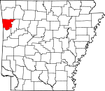
Crawford County, Arkansas Basics:


Crawford County Arkansas - Government Site

Population: 61,943
Area: 593 square miles
County seat: Van Buren
Area code(s) in use: 479
Time zone: CST
High school graduate or higher: 81.2%
Bachelor's degree or higher: 13.3%
Median household income: $39,981
Persons in poverty: 19.3%
Home ownership rate: 72.6%
Mean travel time to work: 21.4 minutes


Adjacent counties:
Adair (OK)  Franklin  Le Flore (OK)  Madison  Sebastian  Sequoyah (OK)  Washington  
Find in Arkansas

Map of the Crawford County area


Our detail map of Crawford County shows the Crawford County, Arkansas boundary lines and other interesting items.

Places in Crawford County, Arkansas

  Airports     show all on map

Crawford Memorial Hospital Heliport, Twin City Airport

  Bridges     show all on map

Broadway Bridge, Lee Creek Bridge, Lee Creek Bridge

  Buildings     show all on map

Alma Fire Department Station 2, Alma Fire Department Station 3, Alma Fire Department Station 4, Alma Police Department, Alma Volunteer Fire Department Station 1, Angel Care Emergency Medical Services - Van Buren, Arkansas Highway Police Van Buren Station, Bond Special Dean Springs and Rudy District 1 Bond Special Fire Station, Bond Special Dean Springs and Rudy District 1 Dean Springs Fire Station, Bond Special Dean Springs and Rudy District 1 Rudy Fire Station, Butterfield District 5 Volunteer Fire Department Figure Five, Butterfield District 5 Volunteer Fire Department Shiloh, Butterfield District 5 Volunteer Fire Department Station 43, Butterfield District 5 Volunteer Fire Department Uniontown, Butterfield District 5 Volunteer Fire Department Webber Creek, CareOne Patient Transfer Service, Crawford County Art Center, Crawford County Courthouse, Crawford County District 3 Turner Station, Crawford County Sheriff's Office, Dyer Fire Station, Dyer Police Department, Kibler Police Department, King Opera House, Mountainburg Fire District 3, Mountainburg Police Department, Mulberry Police Department, Rural District 2 Station 1, Rural District 2 Station 2, Rural District 2 Station 3, Rural District 3 Chester, Rural District 3 Graphic, Rural District 3 Locke, Rural District 4 Cedarville, Rural District 4 Cove City, Rural District 4 Station 88, Rural District 7 Kibler Fire Station 1, Rural District 7 Redhill Fire Station 2, Rural District 8 Station 1, Rural District 8 Station 4, Rural District 9 Station 1, Rural Fire District 6 Station 1, Van Buren Fire Department Station 1, Van Buren Fire Department Station 2, Van Buren Fire Department Station 3, Van Buren Police Department, Van Buren Public Library

  Cemeteries     show all on map

Alexander Cemetery, Antioch Cemetery, Basham Memorial Cemetery, Bateman Cemetery, Beal Cemetery, Bidville Cemetery, Bolton Cemetery, Bratton Cemetery, Bryant Cemetery, Byers Cemetery, Cain Cemetery, Chastain Cemetery, Chester Cemetery, Concord Cemetery, Conley Cemetery, Crow Hill Cemetery, Deans Cemetery, Dobbs Cemetery, Dugan Cemetery, Dyer Cemetery, Echols Cemetery, Fairview Cemetery, Gills Cemetery, Grace Lawn Cemetery, Gregory Cemetery, Hall Cemetery, Harris Cemetery, Hatfield Cemetery, Hillcrest Cemetery, Johnson Cemetery, Kimbler Cemetery, Kimes Cemetery, King Cemetery, Love Cemetery, Macedonia Cemetery, Morrison Cemetery, Mount McCurry Cemetery, Nelson Cemetery, Oak Grove Cemetery, Old Concord Cemetery, Oliver Cemetery, Oliver Springs Cemetery, Peevyhouse Cemetery, Pense Cemetery, Peters Cemetery, Pope Cemetery, Real Cemetery, Salem Cemetery, Sarah Grove Cemetery, Schaberg Cemetery, Simmons Cemetery, Spears Cemetery, Spencer Cemetery, Stevenson Cemetery, Thompson Cemetery, Twelve Corner Cemetery, Winfrey Cemetery, Woods Cemetery, Woods Cemetery, Wynn Graveyard

  Channels     show all on map

Frustee Bend Cutoff

  Churches     show all on map

Alexander Memorial Church, Alma Church, Antioch Church (historical), Antioch Missionary Baptist Church, Bethlehem Freewill Baptist Church, Brooks Chapel, Butterfield Assembly of God Church, Cain Church, Calvary Missionary Baptist Church, Camp Ground Church, Campground Church, Cedarville Baptist Church, Church of Christ, Church of Christ, Church of Christ, City Heights United Methodist Church, Community Chapel Church of God, Community Holiness Lighthouse Church, Concord Baptist Church, Dripping Springs Cumberland Presbyterian Church, Eastern Heights Baptist Church, Eightyeight Church, Eightyone Church, Faith Tabernacle, Fine Springs Baptist Church, First Assembly of God Church, First Baptist Church, First Baptist Church, First Baptist Church, First Presbyterian Church, First United Pentecostal Church, Followers of Christ Church, Freedom Church, Freedom Church, Freedom Ministry Church, Friendly Pentecostal Church of God, Furry Community Church, Gods Lighthouse Pentecostal Holiness Church, Gospel Lighthouse Church, Greater Pilgrim Rest Baptist Church, Gregory Chapel, Harmony Baptist Church, Heritage United Methodist Church, Highway 71 Church, Hillcrest Church, Independence Church, Kenner Chapel, Kibler Baptist Church, Kingdom Hall of Jehovahs Witnesses, Liberty Church, Maple Shade Church, Mosark Church, Mount Olive United Methodist Church, Mountain Grove Church, Mountain View Church, New Home Church, New Hope Baptist Church, New Hope Church, New Hope United Methodist Church, New Testament Holiness Church, Newberry Church, North Park Baptist Church, Number 12 Church, Oak Bower Church, Oak Grove Baptist Church, Oliver Springs Church, Our Lady of the Ozarks Shrine, Parkview Alliance Church, Peaceful Home Church, Pentecostal Church, Pentecostal Church, Pentecostal Church of God, Pentecostal Church of Tomorrow, Plainview Church, Pleasant Home Church, Pleasant Valley Church of Christ, Pointer Trail Baptist Church, Revis Hill Assembly of God Church, Revival Temple, Rudy Church, Saint Mathew Church, Saint Michaels Church, Second Baptist Church, Shamrock Church, Shibley Baptist Church, Solid Rock Tabernacle, Sunnyside Church, Trinity Episcopal Church, Van Buren Church of Christ, Victory Temple, Vista Church, Wood Memorial Christian Church, Zion Missionary Baptist Church

  Crossings     show all on map

Interchange 1, Interchange 1, Interchange 13, Interchange 20, Interchange 24, Interchange 3, Interchange 3, Interchange 5, Interchange 7

  Dams     show all on map

Beverly Hills Lake Dam, Brandenburg Lake Dam, Hall Lake Dam, Hammond Lake Dam, Johnson Lake Dam, Lake Alma Dam, Lake Fort Smith Dam, Lake Lou Emma Dam, Lake Sheppard Spring Dam, Little Mulberry Creek Site Number One Dam, Montgomery Lake Dam, Morris Lake Dam, Mount Gaylor Lake Dam, Swearinger Lake Dam

  Gaps     show all on map

Barker Gap, Dockerys Gap, McMinn Gap, Mullens Gap, The Narrows

  Hospitals     show all on map

Crawford County Memorial Hospital, Summit Medical Center

  Lakes     show all on map

Hollis Lake, Ned Lake, Switchback Lake

  Levees     show all on map

Natural Dam

  Locales     show all on map

Cedars Country Club, Cloverleaf Plaza Shopping Center, Crawford County Industrial Park, Fort Smith Filtration Plant, Goose Harbor Marina, Mountainburg Shelter, North Hills Plaza Shopping Center

  Oilfields     show all on map

Alma Gas Field, Greenwood Junction Gas Field, Hollis Lake Gas Field, Kibler Gas Field, Rudy Gas Field, Section 10 Gas Field, Shibley Gas Field

  Parks     show all on map

Clear Creek Public Use Area, Dam Site North Public Use Area, Kirksey Park, Lake Fort Smith State Park, Lake Louemma Park, Lee Creek Public Use Area, Meyer Park, Miliking Park, Pointers Athletic Field, Van Buren Historic District, Van Buren Municipal Park, Vine Prairie Public Use Area

  Populated Places     show all on map

Alma, Anna (historical), Armada (historical), Artist Point, Ball, Barcelona, Belmont (historical), Bidville, Cain, Catcher, Cedarville, Chester, Concord, Cross Lanes, Davidson, Dean Springs, Deans Market, Dora, Dripping Springs, Dyer, Eastgate Place, Figure Five, Furry, Graphic, Greenwood, Greenwood Junction, Haroldton, Hobbtown, Kibler, Lancaster (historical), Lee Creek, Locke, Maddux Spring, Meadows, Mount Gaylor, Mountainburg, Mulberry, Natural Dam, New Haroldton, New Town, Oak Grove, Pleasant Hill, Rena, Rosedale (historical), Rudy, Schaberg, Shibley, Smeltzer, Stop (historical), Uniontown, Van Buren, Westville, Winfrey, Wright Town, Yoestown

  Post Offices     show all on map

Alma Post Office, Cedarville Post Office, Stattler Post Office (historical), Uniontown Post Office, Van Buren Post Office

  Reservoirs     show all on map

Beverly Hills Lake, Brandenburg Lake, Cold Spring Lake, Hall Lake, Hammond Lake, Johnson Lake, Lake Alma, Lake Fort Smith, Lake Shepherd Springs, Lake Sheppard Spring Reservoir, Lee Creek Reservoir, Louemma Lake, Montgomery Lake, Morris Lake, Mount Gaylor Lake, Ozark Lake, Pine Mountain Lake, Swearinger Lake, T J House Reservoir, Van Buren Water Reservoir

  Ridges     show all on map

Big Mound Ridge, Butlers Ridge

  Schools     show all on map

Alma High School, Alma Intermediate School, Alma Middle School, Alma Primary School, Bidville School (historical), Butterfield Trail Junior High School, Cedarville Elementary School, Cedarville High School, Cedarville Middle School, Chester School (historical), Christian Life Academy, City Heights Elementary School, Coleman Junior High School, Dyer School (historical), Glenwood School (historical), Independence School (historical), J J Izard Elementary School, J J Izard Elementary School, James R Tate Elementary School, James R Tate Elementary School, King Elementary School, Locke School (historical), Marvin Elementary School, Mountainburg Elementary School, Mountainburg High School, Mountainburg Middle School, Mulberry High School, Myer School, Northridge Middle School, Parkview Elementary School, Rena Elementary School, Rena School (historical), Rudy School (historical), Sophia Meyer Elementary School, Stepping Stone School, Van Buren High School, Van Buren Junior High School, Van Buren Middle School, Van Buren School, Van Buren School Number 43

  Springs     show all on map

Cold Spring, Cove Spring, Dripping Spring, Fine Springs, Hennman Spring, Lamar Spring, Maddux Spring, Mullers Spring, Oliver Springs, Sand Spring, Whiskey Spring

  Streams     show all on map

Bear Branch, Bee Branch, Ben Doodle Branch, Blackburn Creek, Buckhorn Creek, Campbell Branch, Cedar Creek, Clear Creek, Cottonwood Slough, Cove Creek, Cow Branch, Crooked Slough, Curry Branch, Doctors Creek, East Cedar Creek, Elmo Creek, Fall Creek, Farm Branch, Flat Rock Creek, Flat Rock Creek, Foster Branch, Frog Bayou, Hart Creek, Herd Branch, Huey Creek, Hurricane Creek, Indian Creek, Jack Creek, Jones Fork, Larue Branch, Lee Creek, Little Brushy Creek, Little Frog Bayou, Little Mulberry Creek, Little Webber Creek, Maxey Creek, Mays Branch, McCaslin Branch, Mill Branch, Miller Branch, Morris Branch, Mountain Fork, Pigeon Creek, Prairie Branch, Riley Creek, Rock Creek, Sherman Creek, Shrader Branch, Sulphur Creek, Sycamore Creek, Tadpole Branch, Vine Prairie Creek, Warloop Creek, Webber Creek, Webster Branch, West Cedar Creek, Whizzen Hollow Creek, Wilson Branch

  Summits     show all on map

Alexander Mountain, Bald Knob, Birchfield Mountain, Bradford Knob, Cartwright Mountain, Chinkapin Knob, Gaylor Mountain, Government Knob, Grapevine Knob, Grassy Mountain, High Rock, Kimes Mountain, Liberty Hill, Lockard Mountain, Locust Mountain, Maxey Mountain, Meadow Mountain, Patrick Mountain, Pine Mountain, Richason Mountain, Shepherd Mountain, Sloan Knob, Wakefield Mountain, Winn Mountain, Winset Mountain

  Towers     show all on map

KAYR-AM (Van Buren), KFDF-AM (Van Buren), KFSM-TV (Fort Smith), KISR-FM (Fort Smith), KLSZ-FM (Van Buren), KPOM-TV (Fort Smith), Mount Gaylor Lookout Tower, Pine Mountain Lookout Tower

  Trails     show all on map

Butterfield Hiking Trail

  Valleys     show all on map

Bonita Hollow, Bowles Gap Hollow, Devils Hollow, Falling Rock Hollow, Gabbard Hollow, Goat Den Hollow, Heathcock Hollow, Huey Hollow, Lick Hollow, Low Gap Hollow, McMinn Hollow, Norman Hollow, Purdue Hollow, Range Hollow, Rattlesnake Hollow, Stob Gap Hollow, Tom Jack Hollow, Wells Hollow, Whitzen Hollow, Woods Gap Hollow,

Crawford County, Arkansas Population By Race (2012 estimate)

RacePopulation
WhiteCrawford County White population 56,80256,801  
MixedCrawford County Mixed population 1,6721,672
American IndianCrawford County American Indian population 1,5491,548
AsianCrawford County Asian population 929929
Hawaiian & Pacific IslanderCrawford County Hawaiian & Pacific Islander population 6261

Additional population tables :
State population table
Arkansas population by county