Franklin County, Arkansas Basics:


Franklin County Arkansas - Government Site

Population: 18,009
Area: 609 square miles
County seat: Ozark
Area code(s) in use: 479
Time zone: CST
High school graduate or higher: 83.2%
Bachelor's degree or higher: 12.5%
Median household income: $35,918
Persons in poverty: 18.7%
Home ownership rate: 74.8%
Mean travel time to work: 24.0 minutes
Adjacent counties:
Crawford  Johnson  Logan  Madison  Sebastian  

Find in Arkansas

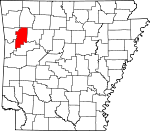
Map of the Franklin County area


Our detail map of Franklin County shows the Franklin County, Arkansas boundary lines and other interesting items.

Places in Franklin County, Arkansas

  Airports     show all on map

Ozark-Franklin County Airport, Whitman Field, Winfield Airpark

  Bends     show all on map

Salt Spring Bend

  Bridges     show all on map

Ozark Bridge

  Buildings     show all on map

Altus Police Department, Altus Rural Fire Department, Altus Volunteer Fire Department, Barnes Volunteer Fire Department, Branch Volunteer Fire Department, Cass Job Corps Center, Cecil Volunteer Fire Department, Charleston Police Department, Charleston Volunteer Fire Department, Franklin County Courthouse, Franklin County Emergency Medical Services, Franklin County Jail, Franklin County Sheriff's Office, Oak Bend Etna Fire Department, Ozark Police Department, Ozark Volunteer Fire Department Station 1, Ozark Volunteer Fire Department Station 2, Pleasant View Volunteer Fire Department, South Ozark - Webb City Fire Department, Watalula Volunteer Fire Department

  Cemeteries     show all on map

Bell Cemetery, Bercham Cemetery, Berkley Cemetery, Bourland Cemetery, Boydston Cemetery, Brewer Cemetery, Browns Chapel Cemetery, Burnett Cemetery, Burrell Cemetery, Burt Cemetery, Campbell Cemetery, Carpenter Cemetery, Childers Cemetery, Council Cemetery, Crossno Cemetery, Dick Hill Cemetery, Duncan Cemetery, Forbus Cemetery, Garden Memorial Cemetery, Greenwood Cemetery, Hamm Cemetery, Hampton Cemetery, Handchew Cemetery, Harmon Cemetery, Harris Cemetery, Henderson Cemetery, Highland Cemetery, Hight Cemetery, Hixon Cemetery, Houston Cemetery, Hunter Cemetery, Jackson Cemetery, Kersey Cemetery, King Cemetery, Lessley Cemetery, Liberty Cemetery, Locke Cemetery, Lone Pine Cemetery, McIlroy Cemetery, McLaughlin Cemetery, McNelly Cemetery, Moffett Cemetery, Morgan Cemetery, Morgan Cemetery, Morgan Hill Cemetery, Mountain View Cemetery, Nickles Chapel Cemetery, Nixon Cemetery, Oak Grove Cemetery, Oak Ridge Cemetery, Parks Cemetery, Patterson Cemetery, Philips Cemetery, Phillips Cemetery, Pilot Grove Cemetery, Pleasant View Cemetery, Plymale Cemetery, Pond Creek Cemetery, Price Springs Cemetery, Quesenbury Cemetery, Rankin Cemetery, Rebecca Lewis Cemetery, Ridge Cemetery, Roger Cemetery, Sacred Heart Cemetery, Saint Anthony Cemetery, Shiloh Cemetery, Shores Cemetery, Singleton Cemetery, Spencer Cemetery, Tate Cemetery, Threadgill Cemetery, Turner Cemetery, Turners Bend Cemetery, Van Brunt Cemetery, Wagner Cemetery, Westview Cemetery, Whitson Cemetery, Williams Cemetery, Younger Cemetery

  Churches     show all on map

Abundant Life Fellowship Church, Altus First Baptist Church, Altus United Methodist Church, Altus United Pentecostal Church, Assembly of God Church, Assembly of God Church, Belt Chapel, Center Point Church, Church of Christ, Church of Christ, Coles Chapel, Corinth Church, Cravens Church (historical), Denning United Methodist Church, Enon Church, Fairview Church, Faith Church, Faith Missionary Baptist Church, First Baptist Church, First United Methodist Church, Free Will Baptist Church, Full Gospel Temple, Gar Creek Church, Grand Prairie Church, Grenades Chapel United Methodist Church, Harmony Church, Hickory Grove Church, Hills Chapel First Christian Church, Jethro Church, Latter Day Saints Church, Latter Day Saints Curch, Low Gap Church, Lowes Creek Church, Marietta Church, Mount Hope Church, Mount Hope Church, Mount View Church, Mount Zion Church, Mountain Top Church, Oak Bend Church, Oak Grove Church, Pleasant Grove Church (historical), Potts Church, Roy Edgar McKee Memorial Chapel, Saint Marys Church, United Methodist Church, Webb City Baptist Church

  Crossings     show all on map

Ham Ford, Interchange 35, Interchange 37, Interstate 41, Kings Ford, Milton Ford, Queensbury Ford, Rock Creek Ford

  Dams     show all on map

Bruce Lake Dam, Cecil Lake Dam, Flanagan Lake Dam, Lake Charleston Dam, Ozark Water Supply Lake Dam, Ozark-Jeta Taylor Lock and Dam, Shores Lake Dam, Sixmile Creek Site 13 Dam, Sixmile Creek Site 14 Dam, Sixmile Creek Site 16 Dam, Sixmile Creek Site 17 Dam, Sixmile Creek Site 18 Dam, Sixmile Creek Site 20 Dam, Sixmile Creek Site 21 Dam, Sixmile Creek Site 22 Dam, Sixmile Creek Site 23 Dam, Sixmile Creek Site 24 Dam, Sixmile Creek Site 25 Dam, Sixmile Creek Site 26 Dam, Sixmile Creek Site One Dam, Swiss Family Vineyards Dam

  Gaps     show all on map

Backbone Narrows, Bowles Gap, Bunce Gap, Fisher Gap, Fly Gap, Rattlesnake Narrows, Stob Gap, Woods Gap

  Hospitals     show all on map

Mercy Hospital Turner Memorial

  Islands     show all on map

Guthrie Island, Honea Island, Okane Island

  Lakes     show all on map

Alix Pond (historical)

  Locales     show all on map

Bee Rock Point of Interest, Camp Frazier (historical), Camp Taft (historical), Shores Lake Campground, Shores Lake Dam Picnic Area, Shores Lake Recreation Area, Summit, Turners Bend, White Rock Creek Overlook

  Oilfields     show all on map

Alix Gas Field, Altus Gas Field, Cecil Gas Field, Lone Elm Gas Field, North Cecil Gas Field, Ozark Gas Field, Paradise Gas Field, Rock Creek Gas Field, Vesta Gas Field, White Oak Gas Field, White Oak Gas Field

  Parks     show all on map

Aux Arc Park, Cherry Bend Recreation Area, Citadel Bluff Park, East Side Park, Eastside Park, Grays Spring Recreation Area, Hurst Memorial Park, Redding Recreation Area, Reed Mountain Park, River Ridge Park, West City Park, West Creek Park (historical), West Side Park, White Oak Park, White Rock Mountain Recreation Area

  Pillars     show all on map

Bee Rock, Spy Rock

  Populated Places     show all on map

Alix, Altus, Anice (historical), Barnes, Beach Grove, Branch, Cass, Cecil, Charleston, Cravens, Dahoma (historical), Denning, Donald (historical), Effa (historical), Etna, Fealey (historical), Felkner Town, Fern, Fly Gap (historical), Fresno (historical), Greenwood, Jethro, Leon (historical), Lone Elm, Meg, Mineral Springs, Mountain Crest, Mountain Grove, Mountain Top, Ozark, Paradise, Peanut, Peter Pender, Piney, Pittston Junction, Pleasant View, Poping, Redding, South Ozark, Sub Rosa (historical), Sutherland Crossroads, Thessing (historical), Toney, Vesta, Watalula, Webb City, West Cobb, White Oak, White Rock, Wiederkehr Village

  Post Offices     show all on map

Alix Post Office, Cecil Post Office, Charleston Post Office, Denning Post Office (historical)

  Reservoirs     show all on map

Bruce Lake, Charleston Lake, Darby Lake, Flanagan Lake, Lake Cecil, Lake Number 20, Lake Number 21, Lake Number 22, Lake Number One, Lake Number Seventeen, Lake Number Sixteen, Lake Number Thirteen, Lake Number Twentyfive, Lake Number Twentyfour, Lake Number Twentysix, Lake Number Twentythree, Ozark City Lake, Shores Lake, Sixmile Creek Site 13 Reservoir, Sixmile Creek Site 14 Reservoir, Sixmile Creek Site 16 Reservoir, Sixmile Creek Site 17 Reservoir, Sixmile Creek Site 18 Reservoir, Sixmile Creek Site 21 Reservoir, Sixmile Creek Site 22 Reservoir, Sixmile Creek Site 23 Reservoir, Sixmile Creek Site 24 Reservoir, Sixmile Creek Site 25 Reservoir, Sixmile Creek Site 26 Reservoir, Sixmile Creek Site One Reservoir, Swiss Family Vineyards Reservoir

  Ridges     show all on map

Bliss Ridge, Burr Ridge, McKay Ridge

  Schools     show all on map

Altus-Denning Elementary School, Altus-Denning High School, Arkansas Valley Vocational Technical Center, Berry Chapel School (historical), Cass Job Corp Center, Charleston Elementary School, Charleston High School, County Line Elementary School, County Line High School, Elgin B Milton Elementary School, Gap School (historical), Lone Oak School (historical), Middle Ridge School (historical), Mineral Hill School (historical), New Hope School (historical), North Liberty School (historical), Oak Ridge School (historical), Ozark 7th Grade School, Ozark Bible Institute, Ozark Elementary School, Ozark High School, Ozark Junior High School, Pleasant View Elementary School, Pleasant View High School, Potts School, Rosenwall School, Webb City School, West Cobb School (historical), Westview School (historical)

  Springs     show all on map

Battle Springs, Burrell Spring, Fern Spring, Fugit Springs

  Streams     show all on map

Barron Creek, Big Foot Branch, Cedar Creek, Cedar Creek, Clear Creek, Clear Creek, Cove Creek, Cravens Creek, Cripple Branch, Dry Fork, Duncan Branch, East Fork Barron Creek, East Fork Gar Creek, Fane Creek, Gar Creek, Garner Creek, Hall Creek, Herrods Creek, Hicks Creek, Hurricane Creek, Indian Creek, John Turner Creek, Left Prong Mountain Creek, Lindsey Branch, Little Mill Creek, Long Branch, Lowes Creek, McHone Creek, McKinney Creek, Mikes Creek, Mill Creek, Moores Creek, Mountain Creek, Mulberry River, North Fork White Oak Creek, Perry Branch, Perry Creek, Phipps Branch, Pond Creek, Pony Creek, Possum Trot Creek, Prairie Creek, Prairie Creek, Rattlesnake Creek, Right Prong Mountain Creek, Rock Creek, Salt Fork Creek, Sandy Branch, Shop Branch, Simpson Branch, Smith Creek, South Fork White Oak Creek, Spirits Creek, Stone Creek, Sulphia Springs Branch, Turkey Creek, West Creek, West Fleming Creek, West Prong Barron Creek, White Oak Creek, White Rock Creek

  Summits     show all on map

Bend Hill, Black Mountain, Bowles Mountain, Boyd Mountain, Brushy Mountain, Burrell Mountain, Carter Mountain, Coal Ridge, Douglas Mountain, Fern Mountain, Fisher Mountain, Grand Ridge, Hare Mountain, Horseshoe Mountain, Hoyle Mountain, Metcalf Hill, Mill Creek Mountain, Mineral Hill, Morgan Mountain, Mount Ephraim, Parker Mountain, Peters Point, Pilot Knob, Pine Hill, Pine Mountain, Pinnacle Mountain, Potato Hill, Potato Knob Mountain, White Rock Mountain, Whiting Mountain, Whiting Mountain, Younger Knob

  Towers     show all on map

Fly Gap Lookout Tower, KDYN-AM (Ozark), KDYN-FM (Ozark), Mountain Lookout Tower

  Trails     show all on map

Shores Lake Water Rock Spur, Spy Rock Redding Loop

  Valleys     show all on map

Alexander Hollow, Bear Hollow, Bear Wallow Hollow, Bend Hollow, Big Eddy Hollow, Big Foot Hollow, Bingham Hollow, Bliss Spring Hollow, Bonds Hollow, Bowden Hollow, Browder Hollow, Buck Hollow, Deep Hollow, Deer Creek Hollow, Devils Canyon, Devils Den Hollow, Dutchman Hollow, Eureka Springs Hollow, Fisher Hollow, Fortner Hollow, Hanging Rock Hollow, Hornbeck Hollow, Marlum Hollow, McBurrel Hollow, McMillan Hollow, Nix Hollow, Philpott Valley, Pine Hollow, Pine Hollow, Pinon Hollow, Rosson Hollow, Shorty Hollow, Soda Hollow, Spy Rock Hollow, Tanyard Hollow, Van Brunt Hollow, Waggley Hollow, Wellcave Hollow, Wildcat Hollow,

Franklin County, Arkansas Population By Race (2012 estimate)

RacePopulation
WhiteFranklin County White population 17,18117,180  
MixedFranklin County Mixed population 252252
American IndianFranklin County American Indian population 234234
AsianFranklin County Asian population 162162
BlackFranklin County Black population 144144
Hawaiian & Pacific IslanderFranklin County Hawaiian & Pacific Islander population 1818

Additional population tables :
State population table
Arkansas population by county