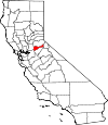
Amador County, California Basics:


Amador County California - Government Site

Population: 37,003
Area: 595 square miles
County seat: Jackson
Area code(s) in use: 209
Time zone: PST
High school graduate or higher: 87.5%
Bachelor's degree or higher: 18.8%
Median household income: $53,462
Persons in poverty: 10.5%
Home ownership rate: 75.8%
Mean travel time to work: 28.5 minutes


Adjacent counties:
Alpine  Calaveras  El Dorado  Sacramento  San Joaquin  

Find in California

Map of the Amador County area


Our detail map of Amador County shows the Amador County, California boundary lines and other interesting items.

Places in Amador County, California

  Airports     show all on map

Camanche Skypark Airport, Eagle's Nest Airport, Horse Shoe A Ranch Airport, Howard (Private) Airport, Ranch Airstrip, Westover Field / Amador County Airport

  Basins     show all on map

Deer Valley

  Bays     show all on map

North Arm

  Buildings     show all on map

Alabama House (historical), Amador County Courthouse, Amador County Jail, Amador County Library, Amador County Museum, Amador Fire Protection District Station 111, Amador Fire Protection District Station 112, Amador Fire Protection District Station 114, Amador Fire Protection District Station 115, Amador Fire Protection District Station 121, Amador Fire Protection District Station 122, Amador Fire Protection District Station 123, American Legion Ambulance, American Legion Ambulance Station 1, American Legion Ambulance Station 3, American Legion Ambulance Station 4, American Legion Ambulance Station 5, Armory Hall, Brignole Building, Caucasian Hall, Chaw'se Regional Indian Museum, Chichizola Building, Claypipers Theatre, Clute Building, Department of Forestry and Fire Protection Academy, Department of Forestry and Fire Protection Pine Grove Conservation, Department of Forestry and Fire Protection Station 10 Dew Drop, Department of Forestry and Fire Protection Station 30 Pine Lodge, Department of Forestry and Fire Protection Station 60 Sutter Hill, Department of Forestry and Fire Protection Station 80 Mount Zion, Fiddletown Community Hall, Fleehart Building, Head House, Ione City Hall, Ione Volunteer Fire Department, Jackson City Fire Department Station 131, Jackson City Fire Department Station 132, Jackson Valley Fire Protection District Station 171, Jackson Valley Fire Protection District Station 172, Kling Building, LeMoine House, Lockwood Fire Protection District Station 151, Lockwood Fire Protection District Station 152, Louisiana House (historical), Mule Creek State Prison, Mule Creek State Prison Fire Department, Peyton Building, Pine Grove Town Hall, Plymouth City Hall, Ratto Theatre, River Pines Town Hall, Roos Building, Schallhorne Building, Shenandoah Valley Museum, Sutter Creek City Hall, Sutter Creek Fire Protection District Station 1 Headquarters, Sutter Creek Fire Protection District Station 2, Torres Hall, United States Forest Service Amador Ranger District Ambulance, Volcano Jail House, Weil Building

  Canals     show all on map

Amador Canal, Arroyo Seco Ditch, Ione Canal, Ione Canal, Isaacs Ditch, Jackson Ditch, Kreth Ditch, Kreth Ditch, Lower Standard Canal, Michigan Bar Ditch, Moore Ditch, Plymouth Ditch, School Ditch, Tiger Creek Conduit, Tiger Creek Regulatory Canal, Volcano Ditch

  Capes     show all on map

Ferguson Point

  Cemeteries     show all on map

Catholic Cemetery, Catholic Cemetery, Catholic Cemetery, City Cemetery, Drytown Public Cemetery, Fiddletown Cemetery, Fiddletown Masonic Cemetery, Independent Order of Oddfellows Cemetery, Ione Protestant-Community Cemetery, Jackson Cemetery, Maidens Grave, New Protestant Cemetery, Oak Knoll Cemetery, Protestant Cemetery, Protestant Cemetery, Saint Stevens Cemetery, Shenandoah Cemetery

  Census     show all on map

Buckhorn Census Designated Place, Buena Vista Census Designated Place, Camanche North Shore Census Designated Place, Camanche Village Census Designated Place, Drytown Census Designated Place, Fiddletown Census Designated Place, Ione Band of Miwok Tribal Designated Statistical Area, Martell Census Designated Place, Pine Grove Census Designated Place, Pioneer Census Designated Place, Red Corral Census Designated Place, River Pines Census Designated Place, Volcano Census Designated Place

  Churches     show all on map

Bethel Assembly of God Church, Congregation B'nai Israel (historical), First Baptist Church, First Baptist Church, Immaculate Conception Catholic Church, Ione Community United Methodist Church, Jackson United Methodist Church, Light and Life Chapel Free Methodist Church, Pine Grove Community Church, Plymouth Baptist Church, Sacred Heart Catholic Church, Saint Bernards Catholic Church, Saint Marys of the Mountains Catholic Church, Saint Patricks Catholic Church, Saint Sava Serbian Orthodox Church, Saint Stevens Catholic Church, Sutter Creek United Methodist Church, Trinity Episcopal Church

  Cliffs     show all on map

Machado Postpiles

  Crossings     show all on map

Bruce Crossing, Whale Boat Ferry (historical)

  Dams     show all on map

Arroyo Seco 471 Dam, Bear River 97-061 Dam, Electra Diversion 97-114 Dam, Goffinet 470 Dam, Henderson 1-010 Dam, Henderson Forebay 1-011 Dam, Jackson Creek 1035 Dam, Jackson Creek Spillway, Jameson 481 Dam, John Orr 483 Dam, Lake Tabeaud 97-067 Dam, Lower Bear River 97-115 Dam, Preston 1-022 Dam, Salt Springs 97-066 Dam, Sand Plant 485 Dam, Shenandoah Lake 486 Dam, Silver Lake 97-058 Dam, Tiger Creek Afterbay 97-105 Dam, Tiger Creek Forebay 97-126 Dam, Tiger Creek Regulator 97-104 Dam, Vicini 487 Dam

  Flats     show all on map

Kirkwood Meadows, Ladeux Meadow, Long Valley, Martin Meadow, Munson Meadow, Onion Valley, Rabbit Flat, Shenandoah Valley, Upper Onion Valley, Whitmore Meadow, Willow Flat

  Forests     show all on map

Mount Zion State Forest

  Gaps     show all on map

Devils Gate, Porthole Gap

  Hospitals     show all on map

Sutter Amador Hospital

  Islands     show all on map

Treasure Island

  Lakes     show all on map

Black Rock Lake, Cole Creek Lakes, Devils Hole Lake, Devils Lake, Granite Lake, Hidden Lake, Kirkwood Lake, Loch Lane, Long Lake, Mosquito Lake, Mud Lake, Oyster Lake, Pardoe Lake, Shriner Lake

  Locales     show all on map

Amador County Landfill, Amador Foothill Winery, Amador Plaza Shopping Center, Amador Ranger Station, Argonaut Winery, Baldinelli Vineyards, Bear River Group Campground, Bear River Resort, Bear River Resort Ski Area, Blacks Station, Buckhorn Lodge, Butte City (historical), California Youth Authority, Camp Eldorado, Camp Minkalo, Camp Silverado, Camp Winton, Central House (historical), Charles Spinetta Vineyards, Clockspring Vineyards, Cole Creek Cabin, Cooks Station, D'Agostini Winery, Deaver Vineyards, Dew Drop Fire Control Station, Domaine De La Terre Rouge-Easton Winery, Dufrene Camp, Ferguson Point Campground, Four Corners, Ginocchio Store (historical), Goodman Ranch, Goosehill Gun Club, Greenstone Winery, Hams Station, Helbing Ranch, Indian Hill, Inspiration Lodge, Inspiration Point, Jackson Gate, Jackson Valley Vineyard, Karly Vineyards, Kayes Resort, Kenworthy Vineyards, Kit Carson Resort, Knights Foundry (historical), Lanes, LDS Camp, Lower Bear River Campground, Mace Meadows Golf Course, Mokelumne River Campground, Montevina Winery, Oneto Ranch, Oyster Creek Campground, Peddler Hill Scenic Viewpoint, Pine Grove Forestry Camp, Pine Lodge California Department of Forestry Station, Plasse Trading Post, Rancheria, Renwood-Santino Winery, Salt Springs Campground, Salt Springs Recreation Site, Santino Winery, Shenandoah Vineyards, Shot Rock Vista Campground, Shot Rock Vista Picnic Area, Shot Rock Vista Scenic Viewpoint, Shriner Lake Campground, Silver Lake Campground, Silver Lake Forest Service Station, Sobon Estate Vineyards, South Shore Campground, Stockton Municipal Camp, Stoneridge Winery, Story Vineyards, Sutter Hill Plaza Shopping Center, Sutter Ridge Vineyards, The Vineyards, Tiger Creek Picnic Area, U'macha'tam'ma Environmental Campsites, Upper Pardoes Camp, Vino Noceto Winery, Votaw Camp, Waits Station, West Point Power House, White Azalea Campground, Youngs Vineyards, Zion California Department of Forestry Station

  Mines     show all on map

Amador Mine, Amador Queen Mine, Argonaut Mine, Belden Mine, Bell Weather Mine, Black Prince Mine, Briarcliff Mines, Buena Vista Pit, Bunker Hill Mine, Central Eureka Mine, China Hill Quarry, Cooper Mine, Copper Hill Mine, Dosch Pit, Empire Mine, Fort Ann Mine, Fremont Mine, Golden Treasure Mine, Gopher Mine, Hardenbergh Mine, Highway 16 Pits, Ione Mine, Ione Pit, Ione Quarry, Irish Hill Pit, Italian Mine, Jackson Valley Quarry, Kennedy Mine, Keystone Mine, Lincoln Mine, Little Amador Mine, Lot 232 Lignite Pit, Marklay Mine, McGuire Pit, Moore Mine, Newton Mine, North Star Mine, Old Eureka Mine, Oneida Mine, Pacific Mine, Pathfinder Mine, Pioneer Mine, Randalls Mine, Schaeffers Diggins, South Eureka Mine, South Jackson Mine, South Spring Hill Mine, T N T Mine, Treasure Mine, Valparaiso Mine

  Parks     show all on map

Amador County Fairgrounds, Charles Howard Park, Detert Park, Indian Grinding Rock State Historic Park, Italian Society Park, Kennedy Tailing Wheels Park, Main Street Park, Minnie Provis Park, Pardee Reservoir Recreation Area, Pine Grove Park, Pioneer Park, Plaza Park, Rancheria Creek Park, Rock Monument, Salt Springs State Game Refuge, Soldiers Memorial Park

  Pillars     show all on map

The Chemisal

  Populated Places     show all on map

Allen, Amador City, Barton, Bonnefoy, Buckhorn, Buena Vista, Bunker Hill, Camanche Village, Carbondale, Chinatown (historical), Clarsona, Clinton, Dagon, Dew Drop (historical), Drytown, Edwin, Electra, Enterprise, Fiddletown, Firebrick, Forest Home (historical), Ione, Irishtown (historical), Jackson, Kit Carson, Lancha Plana (historical), Lower Rancheria (historical), Martell, May (historical), Milligan District (historical), New Chicago, Pine Acres, Pine Grove, Pioneer, Plasse, Plymouth, Pokerville (historical), Ranch House Estates, River Pines, Scottsville, Sunnybrook, Sutter Creek, Sutter Hill, Tragedy Spring (historical), Volcano, Yusumne (historical)

  Post Offices     show all on map

Amador City Post Office, Ione Post Office, Jackson Post Office, Kit Carson Post Office (historical), Pine Grove Post Office, Pioneer Post Office, Plymouth Post Office, Roundtop Post Office (historical), Silver Lake Post Office (historical), Sutter Creek Post Office, Volcano Post Office

  Reserves     show all on map

Mokelumne Wilderness

  Reservoirs     show all on map

Bear River Reservoir, Ellis Fire Tank, Goffinet Reservoir, Henderson Reservoir, Icehouse Pond, Kennedy Reservoir, Lake Amador, Lake Flint, Lake Tabeaud, Loch Lane Lake, Lower Bear River Reservoir, Preston Reservoir, Salt Springs Reservoir, Silver Lake, Tanner Reservoir, Tiger Creek Forbay, Tiger Creek Regulation Reservoir

  Ridges     show all on map

Beaver Ridge, Carson Spur, Cooks Station Ridge, Doaks Ridge, Kirkwood Ridge, Mokelumne Tetons, Panther Ridge, Squaw Ridge

  Schools     show all on map

Aetna School, Amador City School, Amador County High School, Argonaut High School, California Department of Forestry Fire Academy, Carbondale School (historical), Independence High School, Ione Elementary School, Ione Grammar School (historical), Ione High School, Ione Junior High School, Jackson Elementary School, Jackson Junior High School, Jackson Valley School (historical), Milligan School, New York Ranch School, Pigeon Creek School, Pine Grove Elementary School, Pioneer Elementary School, Plymouth Elementary School, Plymouth Primary School, Preston School of Industry, Seventh Day Adventist School, Shenandoah School, Sutter Creek Elementary School, Sutter Creek Grammar School (historical), Sutter Creek Primary School, Union School (historical), Volcano School (historical), Willow Springs School

  Springs     show all on map

Canzatti Spring, Ham Spring, Horse Thief Spring, Mud Spring, Spanish Spring

  Streams     show all on map

Amador Creek, Antelope Creek, Ashland Creek, Bear River, Beaver Creek, Big Indian Creek, Camp Creek, Carson Creek, Cole Creek, Copper Creek, Deadman Fork, Deer Creek, East Panther Creek, Else Creek, Golden Gate Creek, Grass Valley Creek, Green Creek, Horse Creek, Jackass Creek, Jackson Creek, Little Bear River, Little Indian Creek, Little Mill Creek, Little Tiger Creek, Long John Creek, Middle Fork Cosumnes River, Mill Creek, Misery Creek, Mountain Spring Creek, Mule Creek, North Fork Dry Creek, North Fork Jackson Creek, North Fork Mokelumne River, North Fork Rancheria Creek, Oneida Creek, Palama Creek, Panther Creek, Pigeon Creek, Pioneer Creek, Rabbit Creek, Rancheria Creek, Rattlesnake Creek, Rattlesnake Creek, Rock Creek, Slate Creek, South Branch Sutter Creek, South Fork Cosumnes River, South Fork Dry Creek, South Fork Jackson Creek, Spring Valley Branch, Stony Creek, Sugar Pine Creek, Sutter Creek, Sweetwater Creek, Tiger Creek, Tragedy Creek, West Panther Creek, Willow Springs Creek

  Summits     show all on map

Bisbee Peak, Buena Vista Peaks, Bunker Hill, Chrome Mountain, Church Bell Hill, Clinton Peak, Dutschke Hill, Goat Hill, Indian Hill, Irish Hill, Jackson Butte, Martin Point, Mokelumne Peak, Mount Crossman, Mount Zion, Newman Hill, Ohio Hill, Prospect Hill, Quartz Mountain, Rocky Point, Sugarloaf Peak, Thunder Mountain, Trembath Mountain, Tunnel Hill, Two Sentinels, Waters Peak

  Towers     show all on map

KNGT-FM (Jackson)

  Trails     show all on map

North Trail, South Nature Trail

  Tunnels     show all on map

Electra Tunnel, Massa Tunnel, Panther Portal, West Point Tunnel

  Valleys     show all on map

Black Gulch, Box Canyon, Butte Canyon, Cave Gulch, China Gulch, China Gulch, Copper Mine Gulch, Dufresne Gulch, Fourth of July Canyon, Gopher Gulch, Grapevine Gulch, Grapevine Gulch, Grapevine Ravine, Henley Canyon, Hicks Gulch, Hundred Ounce Gulch, Hunt Gulch, Indian Gulch, Ione Valley, Jackass Gulch, Jackson Valley, Kanaka Gulch, Little China Gulch, Minister Gulch, Murphy Gulch, New York Gulch, New York Ranch Gulch, Santa Maria Gulch, School Land Gulch, Snake Gulch, Spanish Gulch, Tanglefoot Canyon, The Gulch, Tule Gulch, Whisky Gulch, Woodpile Gulch, Yagers Gulch,

Amador County, California Population By Race (2012 estimate)

RacePopulation
WhiteAmador County White population 33,63633,635  
MixedAmador County Mixed population 1,1841,184
BlackAmador County Black population 851851
American IndianAmador County American Indian population 777777
AsianAmador County Asian population 444444
Hawaiian & Pacific IslanderAmador County Hawaiian & Pacific Islander population 7474

Additional population tables :
State population table
California population by county