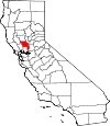
Yolo County, California Basics:


Yolo County California - Government Site

Population: 203,838
Area: 1015 square miles
County seat: Woodland
Area code(s) in use: 916 530
Time zone: PST
High school graduate or higher: 84.2%
Bachelor's degree or higher: 38.0%
Median household income: $57,260
Persons in poverty: 18.7%
Home ownership rate: 53.6%
Mean travel time to work: 21.6 minutes


Adjacent counties:
Colusa  Lake  Napa  Sacramento  Solano  Sutter  

Find in California

Map of the Yolo County area


Our detail map of Yolo County shows the Yolo County, California boundary lines and other interesting items.

Places in Yolo County, California

  Airports     show all on map

Borges - Clarksburg Airport, CHP Academy Airport, G3 Ranch Airport, Joe Heidrick Heliport, Kovr Heliport, Medlock Field Airport, University Airport, Watts-Woodland Airport, Yolo County Airport

  Areas     show all on map

Lamb Valley, Yolo By-Pass

  Bars     show all on map

Haycock Shoals, Twelvemile Bar

  Basins     show all on map

Cache Creek Settling Basin, Cache Creek Sink, Cedar Basin, Paradise Valley, Putah Creek Sinks

  Bends     show all on map

Bullock Bend, China Bend, Fourmile Bend, Freeport Bend, Grays Bend, Ministerial Bend, Portuguese Bend, Railroad Bend, Sacramento Bend, State Ranch Bend, Victor Bend

  Bridges     show all on map

Pioneer Memorial Bridge

  Buildings     show all on map

American Medical Response, Arthur F Turner Branch Yolo County Library, Asmundson Hall, Bainer Hall, Bixby Hall, Briggs Hall, California Institute of Public Affairs Library, California Primate Research Center, Capay Valley Fire Protection District Brooks Station, Capay Valley Fire Protection District Guinda Station, Clarksburg Fire Protection District, Crocker Nuclear Laboratory, Cruess Hall, Davis Branch Yolo County Library, Davis Fire Department Station 31, Davis Fire Department Station 32, Davis Fire Department Station 33, Department of Forestry and Fire Protection Brooks Station, Dunnigan Rural Fire Protection District, Elkhorn Volunteer Fire Department, Emerson Hall, Erwin Meier County Adminstrative Center, Esparto Branch Yolo County Library, Esparto Fire Protection District, Everson Hall, Freeborn Hall, Gibson House Museum, Gilmore Hall, Haring Hall, Hart Hall, Hayes Truck Museum, Hickey Gymnasium, Hoagland Hall, Hunt Hall, Hutchison Hall, Kerr Hall, King Hall, Kleiber Hall, Knights Landing Branch Yolo County Library, Knights Landing Fire Department, Leach Hall, Madison Fire Protection District, Malcolm Hall, Mann Laboratory, Memorial Union, Meyer Hall, Mrak Hall, North Hall, Olson Hall, Parsons Seed Research Laboratory, Porter Building, Recreation Hall, Regan Hall, Robbins Hall, Roessler Hall, Rumsey Rancheria Fire Department, Rumsey Town Hall, Ryerson Hall, Schalm Hall, Scott Cabin, Shields Library, South Hall, Sproul Hall, Storer Hall, Thoreau Hall, University of California Davis Fire Department, Veihmeyer Hall, Veterans Memorial Building, Voorhies Hall, Walker Hall, Webster Hall, Wellman Hall, West Plainfield Fire Protection District, West Sacramento City Hall, West Sacramento Fire Department Station 41, West Sacramento Fire Department Station 42, West Sacramento Fire Department Station 43, West Sacramento Fire Department Station 44, West Sacramento Fire Department Station 45, Wickson Hall, Willow Oak Fire Protection District, Winters Branch Yolo County Library, Winters City Hall, Winters Fire Department, Woodland City Hall, Woodland Fire Department Station 1, Woodland Fire Department Station 2, Woodland Fire Department Station 3, Woodland Opera House, Woodland Public Library, Yolo County Courthouse, Yolo County Jail, Yolo Fire Protection District, Young Hall, Zamora Fire Protection District

  Canals     show all on map

Acacia Canal, Alder Canal, Colusa Basin Drainage Canal, East Adams Canal, Farmers Central Ditch, Highland Canal, Hungry Hollow Canal, Kanaka Cutoff, Knights Landing Ridge Cut, Liberty Cut, Magnolia Canal, Main Canal, Main Canal, Moore Canal, South Fork Ditch, Toe Drain, Townsend Drain, Tule Canal, Tule Canal, West Canal, Willow Canal, Willow Slough Bypass, Winters Canal, Yolo Central Canal

  Capes     show all on map

Willow Point

  Cemeteries     show all on map

Capay Cemetery, Cottonwood Cemetery, Davis Cemetery, Marys Cemetery, Winters Cemetery, Woodland Cemetery

  Census     show all on map

Clarksburg Census Designated Place, Dunnigan Census Designated Place, Esparto Census Designated Place, Guinda Census Designated Place, Knights Landing Census Designated Place, Madison Census Designated Place, Monument Hills Census Designated Place, University of California Davis Census Designated Place, Yolo Census Designated Place

  Channels     show all on map

Collins Eddy Cutoff

  Churches     show all on map

Anna Street Baptist Church, Apostolic Faith Tabernacle, Calvary Baptist Church, Christ Holy Sanctified Church, Christian Church of Woodland, Church of Christ, Church of the Nazarene, Community Methodist Church, First Baptist Church, First Baptist Church of West Sacramento, First Church of Christ Scientist, First Latin American Baptist Church, First Southern Baptist Church of West Sacramento, Full Gospel Assembly of God Church, Full Gospel Church, Grace Romanian Baptist Church, Greater Second Baptist Church, Holy Cross Roman Catholic Church, Holy Murrh Bearing Women Orthodox Church in America, Holy Rosary Convent, Holy Rosary Roman Catholic Church, Kingdom Hall of Jehovahs Witnesses, Russian Church of Evangelic Christian Baptists, Saint Johns United Church of Christ, Saint Lukes Episcopal Church, Saint Martins Church, Saint Paul Catholic Church, Saint Paulus Evangelical Lutheran Church, Sikh Temple of Sacramento, The Church of Jesus Christ of Latter Day Saints, Trinity Presbyterian Church of West Sacramento, Victory Full Gospel Church, West Sacramento Church of the Nazarene, Word of Life Assembly of God Church

  Cliffs     show all on map

Blue Cliffs, Jackson Bluffs

  Crossings     show all on map

Dateys Ferry (historical), Exit 1A, Exit 1B, Exit 3, Exit 81, Exit 82, Exit 83, Sacramento Bypass

  Dams     show all on map

Capay Dam, Elkhorn Weir (historical), Moore Dam, Moore Dam (historical)

  Flats     show all on map

Casey Flats, Cottonwood Flat, Everett Flat, Jones Flat, King Flat, Lindermans Flat, Martin Flat, Mays Flat, Myers Flat, Pace Flat, Rose Briar Flat, Smith Flat, Smith Flat, Winters Flat

  Gaps     show all on map

Horsehead Gate, Rockwell Gap

  Guts     show all on map

Babel Slough, South Fork Cottonwood Slough

  Hospitals     show all on map

Alderson Hospital (historical), Cowell Student Health Center, Sutter Davis Hospital, Woodland Clinic Hospital, Woodland Memorial Hospital, Yolo County General Hospital (historical)

  Islands     show all on map

Merritt Island

  Lakes     show all on map

Beaver Lake, Big Lake (historical), Coon Lake, Greens Lake, Lake Washington, Todhunters Lake (historical), Washington Lake, Winchester Lake

  Levees     show all on map

Fremont Weir, Lovdal Levee, Sacramento Weir, West Levee

  Locales     show all on map

Buckhorn Camp, Cache Creek Dairy, Caltrans Test Center, Camp Haswell, Chapmans Upper Ranch, Clark Ranch, Clarksburg Marina, Conway Ranch, Corbin Ranch, County Fair Mall Shopping Center, Cowell Ranch, Davis Golf Course, Derby Camp (historical), El Macero Golf and Country Club, El Rancho Drive-In (historical), Elston Spur, Fremont Landing, Glide Ranch, Goaters Landing Number One Hundred Fifteen and a Half, Hemp Landing Number Ninety-Seven, Lucky Shopping Center, McFadden Landing Number One Hundred One, Mill Spur, Nathans Landing Number One Hundred Fifteen and a Fourth, Plymans Landing Number One Hundred Fifteen, Port of Sacramento, Riverbend Golf Course, Riverbend Shopping Plaza Shopping Center, S Smith Landing One Hundred Seventeen, Scott Ranch, State Nursery Division of Forestry, Turkey Camp, Tye-A-Lee Landing, University Mall Shopping Center, Vaughn Ranch, Woodland Sewage Farm, Yolo County Central Landfill, Yolo Fliers Club and Golf Course

  Mines     show all on map

Harrison Mine, Madison Pit, Madison Quarry, Reed Mine, Royal Mine

  Oilfields     show all on map

Dunnigan Hills Gas Field

  Parks     show all on map

A Street Intramural Field, Beamer Park, Bemmerly Park, Bryte Park, Cache Creek Regional Park, Camarena Field, Campbell Park, Cedar Park, Central Park, Chestnut Park, Christiansen Park, Civic Center Park, Clark Field, College Park, Community Park, Covell Park, Davis Estates Park, Dewey Halden Field, Dubach Park, Felica Diaz Park, Fremont Weir State Wildlife Area, Harris Park, Hill Park, Holding Pond Park, Howard Intramural Field, Hutchison Intramural Field, Hyman Field, John Ferns Park, Main Intramural Field, Meadowdale Park, Oak Grove Park, Orchard Intramural Field, Oxford Circle Park, Pioneer Park, Play Fields Park, Raley Field, Redwood Park, Sacramento Bypass Wildlife Area, Sam Combs Park, Shields Grove Arboretum, Sycamore Park, Tercero Intramural Field, Toomey Field, Tredway Park, Valley Oak Park, Vernon A Nichols County Park, West Manor Park, Westwood Park, Whaleback Park, William Crawford Senior Park, Woodland Community Swimming Pool, Woodland Opera House State Historic Park, Woodside Park, Yolo County Fairgrounds, Yolo County Park

  Pillars     show all on map

Big Rock, Chimney Rock, Taylor Monument

  Populated Places     show all on map

Arcade, Arroz, Beatrice, Britona (historical), Broderick, Brooks, Browns Corner, Bryte, Bryte Mobile Home Park, Cadenasso, Capay, Capitol City Recreational Vehicle and Mobile Home Park, Capri Mobile Home Park, Casa Mobile Home Park, Central, Citrona, Clarksburg, Conaway, Coniston, Cottonwood, Country Villa Estates, Daisie, Davis, Davis Mobile Estates, Dufour, Dunnigan, Dunnigan Mobile Home Park, El Macero, El Rancho Mobile Park, El Rio Villa, Elvaton (historical), Esparto, Fremont, Garden Acres Mobile Home Park, Green, Greendale, Guinda, Hebron (historical), Hershey, Idle Wheel Mobile Estates, Jacobs Corner, Kiesel, King Farms, Knights Landing, Kobe (historical), Laugenour (historical), Leeman (historical), Leisureville Mobile Home Park, Liwaito (historical), Lovdal, Lund, Madison, Marty (historical), Merritt, Mikon, Morgans Landing, Mullen (historical), Norton, Peart (historical), Peethill, Plainfield, Plumtree (historical), Rancho Yolo Mobile Home Park, Riverside Mobile Home Park, Riverview, Ronda (historical), Royal Oak Manufactured Home Community, Royal Palms Mobile Estates, Rumsey, Saxon, Skylark Mobile Home Park, Sorroca, Sugarfield, Swingle, Tancred, Trails End Mobile Home Park, Tyndall Landing, Valdez, Vin, Walnut Trailer Villa, Webster, West Sacramento, West Sacramento Trailer Park, Westwind Estates, Willow Point, Winters, Winters Mobile Home Park, Woodland, Woodlands Mobile Home Park, Wycoff (historical), Yolo, Zamora

  Post Offices     show all on map

Broderick Post Office, Bryte Branch Broderick Post Office, Davis Post Office, Dunningan Post Office, Esparto Post Office, Knights Landing Post Office, Madison Post Office, West Sacramento Post Office, Winters Post Office, Woodland Post Office, Yolo Post Office, Zamora Post Office

  Ranges     show all on map

Capay Hills, Dunnigan Hills, Sweitzer Hills

  Reservoirs     show all on map

Lake Spafford, Stonegate Lake

  Ridges     show all on map

Blue Ridge, Crane Ridge, Little Blue Ridge

  Schools     show all on map

Alyce Norman Elementary School, Apricot School (historical), Arlingtion Oaks School, Beamer Elementary School, Birch Lane Elementary School, Bryte Elementary School, Ca�on School, Clarksburg Elementary School, Clover School, Cottonwood School (historical), Davis Senior High School, Delta High School, Dingle Elementary School, Douglass Junior High School, Elkhorn Village Elementary School, Emerson Junior High School, Esparto Elementary School, Esparto High School, Evergreen Elementary School, Fairfield School, Fillmore District School (historical), Freeman Elementary School, Gibson Elementary School, Golden State Middle School, Gordon School (historical), Grafton Elementary School, Greengate School, Hesperian College (historical), Highway Patrol Academy, Holy Cross School, Holy Rosary Academy, Indian School, John Clayton Kinderschool, Laugenour School, Lee Junior High School, Madison Community High School, Martin Luther King Continuation High School, Mount Pleasant District School, Mountain School (historical), North Davis Elementary School, Oliver Wendell Holmes Junior High School, Our Lady of Grace School, Pioneer Elementary School, Plainfield Elementary School, Ralph Waldo Emerson Junior High School, Rhoda Maxwell Elementary School, River City High School, Saint James School, T L Whitehead Elementary School, Union School, University of California - Davis, Valley Oak Elementary School, Waggoner Elementary School, Walnut Street Public School (historical), Washington School, West Davis Elementary School, West Davis Intermediate School, West Sacramento School, West Sacramento School for Independent Study, Westfield Village Elementary School, Westmore Oaks Elementary School, Wildwood School, Willow Oak School, Willow Spring Elementary School, Winters High School, Winters Middle School, Woodland Christian School, Woodland Community School, Woodland Senior High School, Wyotech - Sacramento Campus, Yolo High School, Zamora Elementary School

  Slopes     show all on map

East Slope, The Slide

  Springs     show all on map

Adobe Spring, Alder Spring, Bear Spring, Big Spring, Buckhorn Spring, Bull Spring, Butler Spring, Cement Spring, Clapp Spring, Cottonwood Spring, Crooker Spring, Dubois Spring, Duncan Spring, Fredericks Spring, Gibbs Spring, Grapevine Spring, Hays Spring, Indian Mike Spring, King Spring, Lawson Spring, Medical Spring, Morris Spring, Patterson Spring, Stove Spring, Sulphur Spring, Sulphur Spring

  Streams     show all on map

Bird Creek, Bretona Creek, Brooks Creek, Brushy Creek, Buckeye Creek, Cache Creek, Chickahominy Slough, Cottonwood Slough, Davis Creek, Dry Creek, Dry Slough, Dry Slough, Dunnigan Creek, Elk Slough, Enos Creek, Fiske Creek, Goodnow Slough, Hamilton Creek, Lamb Valley Slough, Lawton Creek, Little Buckeye Creek, Middle Fork Bird Creek, Mushoak Creek, North Fork Bird Creek, North Fork Oat Creek, Oat Creek, Old River, Petroleum Creek, Pine Creek, Putah Creek, Salt Creek, Salt Creek, Smith Creek, South Fork Bird Creek, South Fork Buckeye Creek, South Fork Oat Creek, South Fork Putah Creek, South Fork Willow Slough, Sycamore Slough, Union School Slough, Wildcat Creek, Willow Creek, Willow Slough, Willow Spring Creek, Zamora Creek

  Summits     show all on map

Bald Mountain, Black Mountain, Canterbury Mountain, China Peak, Edgar Peak, Glascock Mountain, Langs Peak, Monument Hill, Sugarloaf, Tyndall Mound, Wild Cow Mountain, Windy Point

  Towers     show all on map

KDVS-FM (Davis), KSFM-FM (Woodland), KSMJ-AM (Sacramento), KWHS-FM (West Sacramento)

  Valleys     show all on map

Angus Canyon, Bear Canyon, Benjamin Canyon, Big Canyon, Bird Valley, Bob Walker Canyon, Bray Canyon, Brick Chimney Canyon, Bulliard Basin, Burger Canyon, Capay Valley, Carey Canyon, Chandler Canyon, Chase Canyon, Cobbey Canyon, Cottonwood Canyon, Cross Canyon, Davis Canyon, Eureka Gulch, Fiske Canyon, Fox Canyon, Hamilton Canyon, Hog Canyon, Hungry Hollow, Johnson Canyon, King Canyon, Little Salt Canyon, McKinney Canyon, Murphy Canyon, Oat Valley, Palmer Canyon, Parker Canyon, Parsons Canyon, Perkins Canyon, Pierce Canyon, Pipeline Canyon, Pocket Gulch, Pole Bridge Canyon, Reiff Canyon, Rose Canyon, Rumsey Canyon, Salt Arroyo, Salt Canyon, Smith Canyon, Spencer Canyon, Still Gulch, Tamarack Canyon, Taylor Canyon, Thompson Canyon, Tut Canyon, Wood Canyon

  Wells     show all on map

Wash Clark Well

  Woods     show all on map

Chicken Grove,

Yolo County, California Population By Race (2012 estimate)

RacePopulation
WhiteYolo County White population 155,325155,324  
AsianYolo County Asian population 27,72227,721
MixedYolo County Mixed population 9,7849,784
BlackYolo County Black population 6,1156,115
American IndianYolo County American Indian population 3,6693,669
Hawaiian & Pacific IslanderYolo County Hawaiian & Pacific Islander population 1,2231,223

Additional population tables :
State population table
California population by county