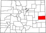
Cheyenne County, Colorado Basics:


Cheyenne County Colorado - Government Site

Population: 1,881
Area: 1778 square miles
County seat: Cheyenne Wells
Area code(s) in use: 719
Time zone: MST
High school graduate or higher: 86.0%
Bachelor's degree or higher: 18.6%
Median household income: $50,357
Persons in poverty: 7.8%
Home ownership rate: 76.5%
Mean travel time to work: 14.3 minutes


Adjacent counties:
Greeley (KS)  Kiowa  Kit Carson  Lincoln  Wallace (KS)  

Find in Colorado

Map of the Cheyenne County area


Our detail map of Cheyenne County shows the Cheyenne County, Colorado boundary lines and other interesting items.

Places in Cheyenne County, Colorado

  Airports     show all on map

Cheyenne Wells Municipal Airport

  Basins     show all on map

Merritt Blowout

  Buildings     show all on map

Cheyenne County Ambulance Service, Cheyenne Wells Fire Department, West Cheyenne Fire Protection District / Kit Carson Fire Department

  Cemeteries     show all on map

Arapahoe Cemetery, Aroya Cemetery, Fairview Cemetery, Kit Carson Cemetery, Wild Horse Cemetery

  Churches     show all on map

Hope Church, Immanuel Church

  Hospitals     show all on map

Keefe Memorial Hospital

  Lakes     show all on map

Arsenic Lake, Lewis Lake, Logie Lake, Skank Lake

  Locales     show all on map

Alpine Ranch, Bledsoe Ranch, Branding Corral Windmill, Brown Mill Ranch, Drift Fence Windmill, Heritage Green Plaza Shopping Center, J O D Ranch, Larson Ranch, Sanders Ranch, School Section Windmill, Settlement, Sorrento, South Windmill, Town Windmill, Twin Windmill, Union Exchange Shopping Center, Windrift Ranch

  Oilfields     show all on map

Cheyenne Oil Field, Golden Spike Oil Field, Ladder Creek Oil Field

  Populated Places     show all on map

Arapahoe, Aroya, Cheyenne Wells, Firstview, Fort Big Spring, Kit Carson, Mount Pearl, Old Wells, Wild Horse

  Post Offices     show all on map

Arapahoe Post Office, Cheyenne Wells Post Office, Kit Carson Post Office, Wild Horse Post Office

  Schools     show all on map

Bear Valley School, Cheyenne Wells High School, Emerson School

  Springs     show all on map

Alfred Camp Spring, Big Spring

  Streams     show all on map

Bellyache Creek, Big Timber Creek, East Fork Big Spring Creek, Eureka Creek, Goose Creek, Ladder Creek, Little Spring Creek, Middle Fork Big Spring Creek, North Fork Ladder Creek, Pass Creek, Rock Creek, Sand Creek, Smoky Hill River, South Ladder Creek, Turtle Creek, White Woman Creek, Wild Horse Creek, Willow Creek

  Summits     show all on map

Agate Mound, Eureka Hill, Landsman Hill, Twin Buttes

  Valleys     show all on map

Adobe Gulch,

Cheyenne County, Colorado Population By Race (2012 estimate)

RacePopulation
WhiteCheyenne County White population 1,8231,822  
American IndianCheyenne County American Indian population 2120
MixedCheyenne County Mixed population 1716
AsianCheyenne County Asian population 1111
BlackCheyenne County Black population 87
Hawaiian & Pacific IslanderCheyenne County Hawaiian & Pacific Islander population 21

Additional population tables :
State population table
Colorado population by county