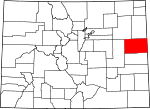
Kit Carson County, Colorado Basics:


Kit Carson County Colorado - Government Site

Population: 8,103
Area: 2161 square miles
County seat: Burlington
Area code(s) in use: 719 970
Time zone: MST
High school graduate or higher: 82.4%
Bachelor's degree or higher: 14.9%
Median household income: $42,832
Persons in poverty: 11.7%
Home ownership rate: 68.4%
Mean travel time to work: 12.5 minutes


Adjacent counties:
Cheyenne  Cheyenne (KS)  Lincoln  Sherman (KS)  Wallace (KS)  Washington  Yuma  

Find in Colorado

Map of the Kit Carson County area


Our detail map of Kit Carson County shows the Kit Carson County, Colorado boundary lines and other interesting items.

Places in Kit Carson County, Colorado

  Airports     show all on map

Aviation Acres Airport, Burlington Municipal Airport (historical), Flagler Aerial Spraying Inc Airport, Hildebrandt Airport, Kit Carson County Airport, Sand Creek Heliport, Silkman Farms Incorporated Airport

  Buildings     show all on map

Burlington Police Department, Burlington Public Library, Burlington Volunteer Fire Department, Community Ambulance Service, Flagler Fire Department, Kit Carson Correctional Center, Kit Carson County Ambulance Service, Kit Carson County Courthouse, Kit Carson County Sheriff's Office, Seibert Fire Department, Stratton Fire Department, Vona Fire Department

  Cemeteries     show all on map

Beaver Valley Cemetery, Calvary Cemetery, Clairmont Cemetery, Fairview Cemetery, Flagler Cemetery, Hope Church Cemetery, New Freidensberg Cemetery, Seibert Cemetery, Smit Cemetery, Vona Cemetery

  Churches     show all on map

Burlington Christian Church, Burlington United Methodist Church, Church of Christ, Evangelical Free Church, First Baptist Church, First Christian Church, New Freidonburg Church, Saint Catherine Catholic Church, Trinity Lutheran Church

  Dams     show all on map

C H Parks Dam, Flagler Dam, Herman Fritzler Erosion Control Number 1 Dam, Verhoeffs Big Dam, Verhoeffs Big Dam, Verhoeffs Little Dam

  Hospitals     show all on map

Kit Carson County Memorial Hospital

  Locales     show all on map

Beverage Ranch, Kipling Crossing, Kit Carson County Fairgrounds, Kit Carson County Landfill, Spring Valley Ranch, Triple H Farms, Wood Ranch

  Parks     show all on map

Flagler Recreation State Area, Outback Territory Park, Parmer Park, Philadelphia Toboggan Company Carousel Number 6

  Populated Places     show all on map

Bethune, Burlington, Flagler, Peconic, Seibert, Stratton, Tuttle (historical), Vona, West Burlington

  Post Offices     show all on map

Bethune Post Office, Burlington Post Office, Flagler Post Office, Seibert Post Office, Stratton Post Office, Vona Post Office

  Reservoirs     show all on map

C H Parks Reservoir, Flagler Reservoir, Herman Fritzler Erosion Control Number 1 Reservoir

  Schools     show all on map

Bethune Junior - Senior High School, Burlington Elementary School, Burlington High School, Burlington Middle School, Green Valley School, Ritzius School, Smoky Hill School

  Streams     show all on map

Big Spring Creek, Bonny Creek, Buffalo Creek, Cow Creek, East Branch Spring Creek, Hell Creek, Landsman Creek, Little Beaver Creek, Middle Beaver Creek, Mud Creek, North Fork Smoky Hill River, Sand Creek, Sandy Creek, Sevenmile Creek, South Beaver Creek, South Fork Landsman Creek, Spring Creek

  Towers     show all on map

KNAB-AM (Burlington), KNAB-FM (Burlington)

  Valleys     show all on map

Dry Gulch,

Kit Carson County, Colorado Population By Race (2012 estimate)

RacePopulation
WhiteKit Carson County White population 7,6827,681  
BlackKit Carson County Black population 170170
MixedKit Carson County Mixed population 113113
American IndianKit Carson County American Indian population 7372
AsianKit Carson County Asian population 4948
Hawaiian & Pacific IslanderKit Carson County Hawaiian & Pacific Islander population 1616

Additional population tables :
State population table
Colorado population by county