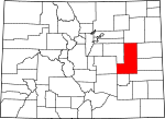
Lincoln County, Colorado Basics:


Lincoln County Colorado - Government Site

Population: 5,449
Area: 2578 square miles
County seat: Hugo
Area code(s) in use: 719
Time zone: MST
High school graduate or higher: 80.4%
Bachelor's degree or higher: 15.8%
Median household income: $43,807
Persons in poverty: 10.1%
Home ownership rate: 69.3%
Mean travel time to work: 16.2 minutes


Adjacent counties:
Arapahoe  Cheyenne  Crowley  El Paso  Elbert  Kiowa  Kit Carson  Pueblo  Washington  

Find in Colorado

Map of the Lincoln County area


Our detail map of Lincoln County shows the Lincoln County, Colorado boundary lines and other interesting items.

Places in Lincoln County, Colorado

  Airports     show all on map

High Mesa Airport, Hugo Municipal Airport, Limon Municipal Airport, Lincoln Community Hospital Heliport, Terra Firma Airport, Thompson Landing Strips

  Buildings     show all on map

Genoa Rural Fire Department, Hugo Volunteer Fire Department, Karval Fire Department, Limon Ambulance Service, Limon Correctional Facility, Limon Fire Protection District, Limon Police Department, Lincoln Community Hospital Transport, Lincoln County Sheriff's Office, Northeast Lincoln Fire Protection District - Arriba

  Canals     show all on map

Beer Ditch, Brett Gray Ditch Number 1, C H Mallon Ditch, Douglas Ditch, Laddie Ditch

  Cemeteries     show all on map

Arriba Cemetery, Arriba Evergreen Cemetery, Bovina Cemetery, Boyero Cemetery, Bucklen Cemetery, Clifford Cemetery, Doctor A H Coulson Grave, Dudley Cemetery, Genoa Community Cemetery, Genoa Lutheran Cemetery, Grandma Forgey Grave, Hugo Evergreen Cemetery, Hugo Old Cemetery, Kirkland Cemetery, Liberty Bell Cemetery, Liberty Cemetery, Lutheran Cemetery, Mount Calvary Cemetery, Parker Cemetery, Pershing Memorial Cemetery, Rube Cemetery, Samuel Messersmith Grave, Spring Hill Cemetery, Walks Camp Cemetery, Walks Camp Lutheran Cemetery

  Churches     show all on map

Blue Cliff Church, Christ Lutheran Church, Walks Camp Lutheran Church

  Cliffs     show all on map

Rock Point, Walker Point, Wild Horse Point

  Dams     show all on map

Amy R Foote Dam, Brett Gray Dam, Clingingsmith Number 2 Dam, Fred Pauls Detention Number 1 Dam, Karval Dam, Kuester Dam, L G Kinney Dam, Lake Creek Dam, Limon Watershed L-1 Dam, Limon Watershed L-2 Dam, Limon Watershed L-3 Dam, Nienhuser Dam

  Flats     show all on map

Ninemile Flats

  Hospitals     show all on map

Lincoln Community Hospital, Plains Medical Center - Limon

  Lakes     show all on map

Beckman Lake, Blakeman Lake, Hubbard Lake, Nelson Lake, Roundtree Lake, Sharp Lake, Stacy Lakes

  Locales     show all on map

Andy Windmill, Bar W W Ranch, Brooks Ranch, Forder, Forder Ranch, Four Corners, Hall Station, Lake, Limon Country Club, Lincoln County Fairgrounds, Rush Creek Ranch, Sevenmile Ranch, T-Cross Ranch, T-Cross Ranch

  Parks     show all on map

Kaval Lake State Recreation Area, Walks Camp Park

  Populated Places     show all on map

Arriba, Bovina, Boyero, Clifford, Genoa, Hugo, Karval, Limon, Punkin Center, Shaw, Wezel (historical)

  Post Offices     show all on map

Arriba Post Office, Genoa Post Office, Hugo Post Office, Limon Post Office

  Reservoirs     show all on map

Amy R Foote Reservoir, Brett Gray Reservoir, Clingingsmith Number 2 Reservoir, Douglas Reservoir, Evilsizer Lake, Fred Pauls Detention Reservoir Number 1, Karval Lake, Karval Reservoir, Kinney Lake, Kuester Reservoir, L G Kinney Reservoir, Lake Creek Reservoir, Limon Watershed L-1 Reservoir, Limon Watershed L-2 Reservoir, Limon Watershed L-3 Reservoir, Nienhuser Reservoir, Sanborn Reservoir, Schafer Reservoir

  Springs     show all on map

Barrel Springs, Bluff Spring, Cockleburr Springs, Dugout Springs, Lofdahl Springs, Lusto Springs, Redwood Tank, Stacy Spring, Willow Spring

  Streams     show all on map

Adobe Creek, Barron Creek, Coon Creek, Cramer Creek, Currie Creek, Dead Horse Creek, Duck Creek, Dugout Creek, East Branch Steels Fork, East Fork Adobe Creek, Hackberry Creek, Hell Creek, Lickdab Creek, Little Horse Creek, North Fork Arikaree River, North Fork Mustang Creek, Pond Creek, Sand Arroyo, Sevenmile Creek, Steels Fork, West Sevenmile Creek

  Summits     show all on map

Insmont Hill

  Towers     show all on map

KLIM-AM (Limon)

  Trails     show all on map

Smoky Hill Trail

  Valleys     show all on map

Aroya Gulch, Barrel Springs Draw, Buffalo Basin, Folger Gulch, McKenzie Draw, Pats Draw, Peace Valley, Rock Basin, Schoolhouse Gulch, Scott Draw, Seldom Ridge Draw, Stacy Lakes Draw, Stanley Gulch

  Wells     show all on map

Monahan Well,

Lincoln County, Colorado Population By Race (2012 estimate)

RacePopulation
WhiteLincoln County White population 4,9594,958  
BlackLincoln County Black population 294294
MixedLincoln County Mixed population 8281
American IndianLincoln County American Indian population 6059
AsianLincoln County Asian population 4443
Hawaiian & Pacific IslanderLincoln County Hawaiian & Pacific Islander population 55

Additional population tables :
State population table
Colorado population by county