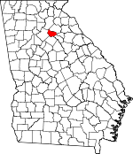
Barrow County, Georgia Basics:


Barrow County Georgia - Government Site

Population: 70,165
Area: 160 square miles
County seat: Winder
Area code(s) in use: 770
Time zone: EST
High school graduate or higher: 80.4%
Bachelor's degree or higher: 16.6%
Median household income: $51,202
Persons in poverty: 13.6%
Home ownership rate: 77.8%
Mean travel time to work: 33.3 minutes


Adjacent counties:
Athens - Clarke  Gwinnett  Hall  Jackson  Oconee  Walton  

Find in Georgia

Map of the Barrow County area


Our detail map of Barrow County shows the Barrow County, Georgia boundary lines and other interesting items.

Places in Barrow County, Georgia

  Airports     show all on map

Barrow County Airport, Barrow Medical Center Heliport

  Bridges     show all on map

Hancock Bridge, Kilgore Mill Covered Bridge, Tanners Bridge

  Buildings     show all on map

Auburn City Hall, Auburn Fire / Rescue Department, Auburn Police Department, Barrow County Courthouse, Barrow County Fire and Emergency Services Station 6, Barrow County Jail, Barrow County Sheriff's Office, Bethlehem City Hall, Bethlehem Fire Department Station 3, County Line Fire Department Station 5, Georgia Forestry Commission Clarke - Oconee Office, Statham City Hall, Statham Police Department, Statham Volunteer Fire Department, Winder City Hall, Winder Depot, Winder Fire Department Station 1, Winder Fire Department Station 2, Winder Police Department

  Cemeteries     show all on map

Barrow Memorial Gardens, Booth Memorial Park, Carl Cemetery, Carter Hill Cemetery, Harmony Grove Cemetery, Helton Cemetery, House Cemetery, Midway Cemetery, Millsaps Cemetery, Omer Cemetery, Peppers Cemetery, Rose Hill Cemetery, Rose Hill Cemetery, Russell Cemetery, Smith Cemetery, Statham Cemetery, Wood Cemetery

  Census     show all on map

Russell Census Designated Place

  Churches     show all on map

Apalachee Church, Apalachee Shoals Church, Auburn First Baptist Church, Auburn Park Chapel, Auburn United Methodist Church, Austin Chapel, Barber Creek Church, Bethabra Church, Bethel Church, Bethlehem African Methodist Episcopal Zion Church, Bethlehem Church, Bethlehem Church, Bush Chapel African Methodist Episcopal Church, Calvary Church, Calvary Church, Carl Baptist Church, Carter Hill Church, Cedar Creek Church, Chapel Church, Church of Jesus Christ, Corinth Church, Cornerstone Church, East Side Baptist Church, Eastside Church, Fairfield Church, First Baptist Church, First Christian Church, First Presbyterian Church, First United Methodist Church, Gospel Light Church, Grace Church, Greater Barber Creek Church, Harmony Grove Church, Living Word Church, Midway Church, Midway Church, Nazareth Church, New Pentecost Church, Old Pentecost Church, Omer Church, Pentecostal Temple, Philadelphia Christian Church (historical), Pleasant Hill Church, Providence Church, Rockwell Church, Sharon Church, Smith Chapel Church, Temple of God, Trinity Church, Union Church, Whistleville Christian Church, Winder Wesleyan Methodist Church

  Crossings     show all on map

Exit 48

  Dams     show all on map

Barber Creek Watershed Structure 25 Dam, Cruce Dam, Elder Lake Dam, Fort Yargo Lake Dam, Guyouzts Dam, Harrison Dam, Lesters Lake Dam, Lokeys Lake Dam, Lower Twin Lake Dam, Marbury Lake Dam, Masseys Lake Dam, Rives Lake Dam, Rutledge Lake Dam, Watershed Lake Dam, Watershed Number 9 Barber Creek Dam, Winder Reservoir Dam

  Hospitals     show all on map

Barrow Medical Center, Winder-Barrow Hospital (historical)

  Locales     show all on map

County Line, Pine Hills Golf Course

  Military     show all on map

Fort Yargo (historical)

  Parks     show all on map

Athens-Candler-Church Street Historic District, Broad Street Commercial Historic District, Fort Yargo State Park, Jackson Street Commerical Historic District, North Broad Street Residential Historic District, Russell Homeplace Historic District

  Populated Places     show all on map

Algernon (historical), Auburn, Barrow Heights, Bethlehem, Cains Courthouse (historical), Carl, Cedar Hill, Gooberville, Mulberry, Russell, Statham, Thompsons Mill, Whistleville, Winder

  Post Offices     show all on map

Winder Post Office

  Reservoirs     show all on map

Barber Creek, Cruce Lake, Elder Lake, Fort Yargo Lake, Guyouzts Lake, Harrison Lake, Lesters Lake, Lokeys Lake, Lower Twin Lake, Marburg Creek, Marbury Lake, Masseys Lake, McLocklin Lake, Perkins Lakes, Rives Lake, Rutledge Lake, Watershed Lake, Winder Reservoir

  Schools     show all on map

Apalachee High School, Auburn Elementary School, Auburn High School (historical), Auburn Junior High School (historical), Barbers Creek School (historical), Barrow County Alternative Center, Bethel School (historical), Bethlehem Elementary School, Bethlehem Junior High School (historical), Bradley School (historical), Bramlett Elementary School, Carter Hill School (historical), Cedar Creek School (historical), Corinth School (historical), County Line Elementary School, Fairfield School (historical), Harmony Grove School (historical), Haymon - Morris Middle School, Hintons Academy (historical), Holsenbeck Elementary School, Hope Christian Academy, Kennedy Elementary School, Mount Bethel School (historical), Nazareth School (historical), Rockwell School (historical), Russell Middle School, Smiths Chapel School (historical), Southeastern Christian College (historical), Statham Elementary School, Tanners Bridge School (historical), Victory School (historical), Westside Middle School, Whistleville Christian School, Winder - Barrow High School, Winder - Barrow Middle School, Winder Grade School (historical), Winder High School (historical), Yargo Elementary School

  Streams     show all on map

Beaver Dam Creek, Beech Creek, Cedar Creek, Harvey Branch, Hawk Creek, Little Bear Creek, Little Mulberry River, Marbury Creek, Mulberry River, Rock Creek, Rocky Creek, Rocky Creek

  Towers     show all on map

WBPS-FM (Winder), WIMO-AM (Winder),

Barrow County, Georgia Population By Race (2012 estimate)

RacePopulation
WhiteBarrow County White population 57,81657,815  
BlackBarrow County Black population 8,0698,068
AsianBarrow County Asian population 2,4562,455
MixedBarrow County Mixed population 1,4031,403
American IndianBarrow County American Indian population 351350
Hawaiian & Pacific IslanderBarrow County Hawaiian & Pacific Islander population 7070

Additional population tables :
State population table
Georgia population by county