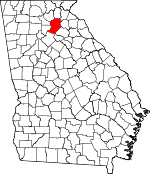
Hall County, Georgia Basics:


Hall County Georgia - Government Site

Population: 185,055
Area: 393 square miles
County seat: Gainesville
Area code(s) in use: 770
Time zone: EST
High school graduate or higher: 78.5%
Bachelor's degree or higher: 22.1%
Median household income: $52,174
Persons in poverty: 16.8%
Home ownership rate: 68.6%
Mean travel time to work: 25.8 minutes


Adjacent counties:
Banks  Barrow  Dawson  Forsyth  Gwinnett  Habersham  Jackson  Lumpkin  White  

Find in Georgia

Map of the Hall County area


Our detail map of Hall County shows the Hall County, Georgia boundary lines and other interesting items.

Places in Hall County, Georgia

  Airports     show all on map

B Tree Farms Airport, Fly-N-S Ranch Airport, Lanier Park Hospital Heliport, Latham Creek Heliport, Lee Gilmer Memorial Airport, Stouffer Pine Isle Resort Heliport

  Bars     show all on map

Glade Shoals

  Bays     show all on map

Chattahoochee Bay, Flowery Branch Bay

  Bridges     show all on map

Bells Mill Bridge, Bellton Bridge, Bolding Bridge (historical), Bolling Bridge, Browns Bridge, Clark Bridge, Clark Bridge Access Point, Davis Bridge Access Point, Keith Bridge (historical), Lanier Bridge, Longstreet Bridge, Longstreet Bridge Access Point, Lula Bridge, Thompson Bridge, Thompson Bridge Access Point, Wahoo Creek Bridge, Wilkie Bridge

  Buildings     show all on map

Chicopee Woods Agricultural Center, Flowery Branch City Hall, Flowery Branch Police Department, Gainesville City Hall, Gainesville Civic Center, Gainesville Fire Department Station 1, Gainesville Fire Department Station 2, Gainesville Fire Department Station 3, Gainesville Fire Department Station 4, Gainesville Police Department, Gainesville Police Department, Gainesville Police Department Harrison Square Precinct, Gainesville Police Department Headquarters, Gainesville Police Department Mall Precinct, Gainesville Police Department Melrose Precinct, Georgia State Patrol Troop B Post 6 Gainsville, Hall County Courthouse, Hall County Fire Services Station 1, Hall County Fire Services Station 10, Hall County Fire Services Station 11, Hall County Fire Services Station 12, Hall County Fire Services Station 13, Hall County Fire Services Station 14, Hall County Fire Services Station 15, Hall County Fire Services Station 2, Hall County Fire Services Station 21, Hall County Fire Services Station 3, Hall County Fire Services Station 4, Hall County Fire Services Station 5, Hall County Fire Services Station 6, Hall County Fire Services Station 7, Hall County Fire Services Station 8, Hall County Fire Services Station 9, Hall County Jail, Hall County Sheriff's Department, Hall County Sheriff's Office, North Georgia Detention Center, Northeast Georgia Visitor Information Center, Oakwood City Hall, Oakwood Police Department, Quinlan Art Center, Satterfield Store, South Hall Community Center

  Capes     show all on map

Wahoo Creek Access Point

  Cemeteries     show all on map

Airline Cemetery, Alta Vista Cemetery, Antioch Cemetery, Bellton Baptist Cemetery, Belmont Cemetery, Broadlawn Memorial Gardens, Calvary Cemetery, Calvary Memorial Gardens, Candler Cemetery, Chattahoochee Cemetery, Chestatee Cemetery, Chestnut Mountain Cemetery, Clemons Chapel Cemetery, Cool Springs Cemetery, Corinth Cemetery, Dewberry Cemetery, Dewberry Cemetery, Dunagans Chapel Cemetery, Eureka Cemetery, Flat Creek Cemetery, Flowery Branch Cemetery, Fraiser Cemetery, Gainesville Mill Cemetery, Hall County Memorial Park, Harmony Hall Cemetery, Holly Springs Cemetery, Hulsey Cemetery, Jarrett Cemetery, Kennedy Cemetery, King Cemetery, Lebanon Cemetery, Living Mission Cemetery, Lott Cemetery, Macedonia Cemetery, Martin Cemetery, Mount Salem Cemetery, Mount Vernon Cemetery, Mountain View Cemetery, New Bethany Cemetery, New Bridge Cemetery, New Holland Cemetery, Oak Grove Cemetery, Oakwood Cemetery, Pine Grove Cemetery, Pleasant Hill Cemetery, Pleasant Hill Cemetery, Poplar Springs Cemetery, Prospect Cemetery, Redwine Cemetery, Rock Hill Cemetery, Sardis Cemetery, Skitts Mountain Cemetery, Smith Cemetery, South Bend Cemetery, Springway Cemetery, Sugar Hill Cemetery, Timber Ridge Cemetery, Trinity Cemetery, Union Cemetery, Walka Mountain Cemetery, Waters Cemetery, Whitehall Cemetery, Woodlawn Cemetery, Yellow Creek Cemetery, Young Cemetery, Zion Hill Cemetery

  Churches     show all on map

Airline Baptist Church, Antioch Baptist Church, Antioch Church, Bellton Church, Belmont Baptist Church, Bethel Church, Bethel Church, Bethel Tabernacle, Bethlehem Church, Bethlehem Church, Calvary Church, Calvary Church, Calvary Cross Church, Canaan Church, Candler Methodist Church, Central Baptist Church, Chattahoochee Baptist Church, Chestatee Church, Chestnut Mountain Baptist Church, Chestnut Mountain Presbyterian Church, Chicopee Baptist Church, Chicopee United Methodist Church, Christ First Church, Christ Lutheran Church of God, Christian Church, Christian Hall Church, Church of God, Church of God of Prophecy, Clemons Chapel, Cool Springs Church, Corinth Baptist Church, Cornith Church, Covenant Connections Church, Cross Plains Church, Cross Road Church, Dewberry Church Number 1, Dewberry Church Number 2, Dunagan Chapel, East Hall Baptist Church, East View Church, Emmanuel Church, Enon Church, Faith Church, Faith Tabernacle, First Baptist Church, First Baptist Church, First Baptist Church, First Baptist Church of Oakwood, First Congregational Holiness Church, First United Methodist Church, Flat Creek Church, Flowery Branch United Methodist Church, Fountain of Faith Church, Free Methodist Church, Free Methodist Tabernacle, Friendship Church, Friendship Church, Full Gospel Tabernacle, Gainesville Church, Gospel Assembly Church, Grace Church, Grace Episcopal Church, Greater Timber Ridge Church, Harmony Hall Church, Harmony Street Baptist Church, Holiness Church, Holly Springs Church, Hopewell Church, Hopewell Church, Lakewood Church, Lanier Church, Lebanon Church, Lighthouse Church, Living Mission Church, Living Word Tabernacle, Macedonia Church, McEver Road Baptist Church, Memorial Park Church, Mercy Church, Midway Church, Montgomery Memorial Baptist Church, Morningside Church, Mount Calvery Church, Mount Salem Church, Mount Vernon Church, Mount Zion Church, Mountain View Church, Murrayville Church, Murrayville Church, Murrayville Holiness Church, New Bethany Church, New Bridge Church, New Holland Baptist Church, Northlake Church, Northside Church, Oak Grove Baptist Church, Oakwood Gospel Tabernacle, Open Door Church, Open Door Church, Peoples Church, Pilgrim Church, Pine Grove Church, Pinecrest Church, Piney Grove Church, Pleasant Hill Church, Pleasant Hill Church, Pleasant Hill Church, Pleasant Hill Church (historical), Pleasant Union Church, Poplar Springs Church, Prospect Church, Redwine Church, River Bend Church, Rock Hill Church, Rucker Memorial Church, Saint John Baptist Church, Saint Michaels Catholic Church, Saint Paul African Methodist Episcopal Church, Saint Paul United Methodist Church, Sardis Church, Shoal Creek Church (historical), Skitts Mountain Church, South Bend Church, South Hall Church, Springway Church, Straightway Church, Sugar Hill Church, Tadmore Church (historical), Temple Church, The Rock Church Flowery Branch, Timber Ridge Church, Trinity Church, Union Church, Walka Mountain Church, Welcome Home Church, West Hall Baptist Church, Westminster Presbyterian Church, White Hall Church, Woodlawn Church, Yellow Creek Church, Zion Hill Church

  Crossings     show all on map

Crowder Ford, Exit 2, Exit 3, Exit 4, Exit 5, Exit 6, Exit 7, Gaines Ferry (historical), Grant Ford (historical), Keith Ferry (historical), Rocky Bottom Ford (historical), Seven Island Ford (historical), Shadburn Ferry (historical), Shallow Ford (historical), Stringer Ford (historical), Wilkie Ford (historical), Wooley Ford (historical)

  Dams     show all on map

Brenau Lake Dam, Gainesville Stone Lake Dam, Gilbert Dam, Glade Lake Dam, L Cooper Lake Dam, Looper Lake Dam, Martins Lake Dam, Middle Oconee Structure Number Nine Dam, Middle Oconee Structure Number One Dam, Middle Oconee Structure Number Seven Dam, Miller Lake Dam, Ponys Lake Dam, Ramsey-Fraser Lake Dam, Walker Mountain Lake Dam, Whitmire Lake Dam, Woodmen Youth Camp Dam

  Hospitals     show all on map

Lanier Park Hospital, Northeast Georgia Medical Center

  Locales     show all on map

Airport Industrial Park, Antioch Campground, Aqualand Marina, Balus Creek Access Point, Bamboo Village Shopping Center, Bells Mill Access Point, Big Creek Access Point, Blue Ridge Shopping Center, Bolling Mill Access Point, Broad Street Shopping Center, Buford Waterworks, Burton Mill Access Point, Carvers Mill (historical), Centennial Industrial Park, Chattahoochee Country Club, Chattahoochee Golf Club, Cherokee Gun Club Range, College Square Shopping Center, Duckett Mill Access Point, Duncan Cross Roads, Federal Crossing, Flat Creek Sewage Disposal, Gainesville Industrial Park North, Gainesville Industrial Park South, Gainesville Marina, Gainesville Waterworks, Gainesville West Shopping Center, Hall Creek Village Business Park, Hampton Mill (historical), Heads Mill, Holiday-on-Lake Lanier Marina, Howser Mill (historical), Jefferson Park Access Point, Lake Lanier Sailing Club, Lakeshore Plaza Shopping Center, Lakeshore Village Shopping Center, Lanier Plaza Shopping Center, Lanier Speedway, Lanier Yacht Club, Latty Station (historical), Linwood Sewage Disposal, Little Hall Park, Little River Access Point, Mauldins Mills (historical), McEvers Corners Shopping Center, Merchants Crossing Shopping Center, Merchants Walk Shopping Center, Mountain View Access Point, Northlake Plaza Shopping Center, Oconee Mills (historical), River Forks Park, Road Atlanta Speedway, Robinson Access Point, Sardis Creek Access Point, Sherwood Plaza Shopping Center, Shoal Creek Camping Area, Simpson Access Point, Snug Harbor Marina, Town View Plaza Shopping Center, University Yacht Club, Washington Plaza Shopping Center, Washington Square Shopping Center, Westside Shopping Center, White Sulphur Access Point, Woodmen of the World Youth Camp

  Military     show all on map

Naval Air Facility Gainesville (historical)

  Parks     show all on map

Alberta Banks Park, Aqualand Park, Brenau College Historic District, Chestnut Ridge Park, Chicopee Mill and Village Historic District, Chicopee Woods Park, Clermont Residential Historic District, Cool Springs Access Point, Dogwood Park, Don Carter State Park, Flowery Branch Commercial Historic District, Flowery Branch Park, Gainesville Park Access Point, Green Street-Brenau Historic District, Highway Fiftythree Access Point, Holly Park, Ivy Terrace Park, Johnson Creek Access Point, Lake Lanier Islands Park, Latham Creek Access Point, Laurel Park, Little Shoal Creek Public Use Area, Lula Park, Lula Residential Historic District, Old Federal Road Park, Platt Park, Roper Park, Upper Latham Creek Access Point, Van Pugh Park, Yonah Park

  Populated Places     show all on map

Absalom (historical), Ahaluna, Alandale, Atlas Circle, Bailey, Balus Creek, Bark Camp Place, Barnes, Barrett, Beach Haven Heights, Beard, Beaver Pond, Bellton, Belmont, Belton, Belvedere Acres, Bentwood, Beverly Hills, Big Oak, Blackshear Place, Blueberry Hills, Bolman Estates, Botany Woods, Bretton Woods, Briarwood, Broadnax, Brookton, Brookwood, Byers, Camellia Heights, Cameron Point, Candler, Cascade Woods, Chapman, Chattahoochee Landing, Chattahoochee Place, Cherokee Hills, Cherokee Meadows, Cherokee Trail, Cherrywood, Chestatee North, Chestnut Hill, Chestnut Mountain, Chestnut Oak Hills, Chicopee, Clarks Bridge, Clarks Bridge Place, Clermont, Colony South, Cool Springs Forest, Country Club Gardens, Crown Point, Destitute Acres, Devane, Dixie Hills, Dunagan, Eaglewood, Elrod, Evergreen Heights, Flat Creek, Fleetwood, Flowery Branch, Forest Park, Fox Hollow, Fox Trace, Fran Mar Heights, Frazier, Frontier Trail, Gainesville, Gainesville Mills, Gay Lan, Gilleland, Glades, Gower Springs (historical), Green Crossing, Green Hills, Green Meadows, Greenway, Greystone, Griffin Heights, Hammer, Happy Valley, Hargrove, Hayes, Heather Heights, Hidden Acres, Hidden Harbor, Hillcroft Heights, Holiday Heights, Holiday Hills, Holiday Meadows, Holiday Villa, Holland, Holland, Indian Hills, Jarrett, Johnson, Johnstown (historical), Kemp, Klondike, Lake Farm, Lake Forest, Lake Haven, Lake Ranch, Lake Shore, Lake Watch, Lakeland Heights, Lakeshore Estates, Land (historical), Lanier North Woods, Lanier Northwest, Lanier Valley, Laurel Hills, Lawson Highlands, Le Dan, Leisure Lake, Loch Arbor, Looper Lake, Lula, Maple Forge, Marlette Heights, Marlow, McClure, McCrary, McEver, Meadowood, Mill Creek, Mill Ridge, Misty Cove, Mooney, Moore, Morning Side Hills, Mountain View, Mountain View, Mulberry, Mundys Point, Murrayville, New Holland, North Banks Cove, North Forest, Northcliff Colony, Northlake, Oak Harbor, Oakhill, Oakwood, Olde Federal Pointe, Pine Forest, Pine Haven, Pine Hills, Pine Point, Pinecrest Heights, Pleasant Brook, Pleasant View, Point View Landing, Price, Quail Run, Quiet Place in the Woods, Rabbitown, Rainbow Village, Raintree East, Raintree West, Reed, Reed, River Point, River Run, Riverbend, Roberts Crossroads, Sagamore, Sallee Heights, Sardis Heights, Sardis Shores, Scotts Cove, Scoutland, Serene Shores, Shady Lane, Shady Valley, Shamrock Heights, Sidney on Lanier, Southgate, Spout Spring Crossroads, Spring View Acres, Springdale, Springdale Forest, Springfield Downs, Squirrel Creek, Stevens, Strickland Heights, Sugar Hill, Summer Point, Sundown on Lanier, Sunset Heights, Surf Side Club Estates, Tanner, Tanner Mill, Tapawingo, The Bluffs, Thompson Mill, Timberidge, Trudy, Trudy Estates, Tumlin Heights, Twin Rivers, Tyner, Venture Cove, Vickers, Vista Brook, Wahoo Forest, Wahoo Valley, Walden Woods, Waterford, Waverly Way, Wayne, Weatherford, Welchell, Westgate, Westside, Westview, Whelchel, White, White Sands, White Sulphur, White Sulphur Springs, White Sulphur Station (historical), Whitmire, Whitmire, Wild Fern, Wildwood Heights, Wolfs Head, Woodbridge, Woodlake, Woodlake

  Post Offices     show all on map

Flowery Branch Post Office, Gainesville Post Office

  Reservoirs     show all on map

Brenau Lake, Gainesville Stone Lake, Glade Lake, Looper Lake, Looper Lake Dam, Martins Lake, McEver Lake, Miller Lake, Pine Lake, Ponys Lake, Ponys Lake, Ramsey-Fraser Lake, Reservoir Nine, Reservoir One, Reservoir Seven, Walker Mountain Lake, Whitmire Lake, Woodmen Youth Camp Lake

  Schools     show all on map

Air Line School, Airline School (historical), Alpine Educational Program School, Ben Hill School (historical), Brenau Academy, Brenau University, Brenau University, Bristol School (historical), C W Davis Middle School, Candler Street School, Centennial Elementary School, Center School (historical), Chattahoochee Christian School, Chestatee High School, Chestatee Middle School, Chestnut Mountain Elementary School, Chicopee Woods Elementary School, Eagle Ranch Christian School, East Hall High School, East Hall Middle School, Enon School (historical), Enota Elementary School, Fair Street Elementary School, Flowery Branch Elementary School, Flowery Branch Elementary School, Flowery Branch High School, Flowery Branch School, Friendship Elementary School, Gainesville Christian School, Gainesville Exploration Academy, Gainesville High School, Gainesville Learning Academy, Gainesville Middle School, Gainesville Mill School, Gainesville State College, Gilmer Academy (historical), Good Shepard Lutheran School, High Hill School (historical), Interactive College of Technology Gainesville Campus, Jeffersonian School (historical), Johnson High School, Jones Elementary School, Jubilee Christian Academy, Lakeview Academy, Lanier Career Academy, Lanier Elementary School, Lanier Technical College, Lanier Technical College Oakwood Campus, Lula Elementary School, Lyman Hall Elementary School, Lyman Hall School, Main Street School, Manranatha Christian Academy Oakwood Extension, Maranatha Christian Academy, Martin Elementary School, McEver Elementary School, Miller Park School, Mount Vernon Elementary School, Mount Vernon School (historical), Myers Elementary School, New Gainesville Middle School, New Holland Core Knowledge Academy, North Georgia Christian School, North Hall High School, North Hall Middle School, North Hall School, Oakwood Elementary School, Piney Grove School (historical), Pool School (historical), Price School (historical), Radford School, Riverbend Elementary School, Riverside Military Academy, Sardis Elementary School, Sardis School (historical), Skitt Mountain School (historical), South Hall Middle School, Spout Springs Elementary School, Sprout Springs Elementary School, Sugar Hill Elementary School, Tadmore Elementary School, The International Center, Trinity Day School, Wauka Mountain Elementary School, West Hall High School, West Hall Middle School, White Hall School (historical), White Sulphur Elementary School, World Language Academy

  Streams     show all on map

Ada Creek, Allen Creek, Balus Creek, Bellton Creek, Big Creek, Buffington Mill Creek, Bull Creek, Candler Branch, Caney Fork, Cedar Creek, Cooper Creek, Cry Creek, Deaton Creek, Dog Creek, Duncan Creek, East Fork Little River, Eubank Creek, Flat Creek, Flat Creek, Flowery Branch, Garner Creek, Gin Branch, Hagen Creek, Head Mill Creek, Johnson Creek, Latham Creek, Limestone Creek, Little John Creek, Little Mud Creek, Little River, Little Yellow Creek, Lollis Creek, Lott Creek, Martin Creek, Mitchell Creek, Mossy Creek, Mud Creek, Mud Creek, Mulberry Creek, Pitts Creek, Redwine Creek, Sardis Creek, Sherwood Creek, Shoal Creek, Split Oak Creek, Squirrel Creek, Wahoo Creek, Walnut Creek, West Fork Little River, Yellow Creek

  Summits     show all on map

Banks Mountain, Buckhorn Mountain, Hog Mountain, Kennedy Mountain, Price Mountain

  Towers     show all on map

Nopone Lookout Tower, WBCX-FM (Gainesville), WDUN-AM (Gainesville), WFOX-FM (Gainesville), WGGA-AM (Gainesville), WKZD-AM (Murrayville), WLBA-AM (Gainesville), WYAY-FM (Gainesville),

Hall County, Georgia Population By Race (2012 estimate)

RacePopulation
WhiteHall County White population 161,923161,923  
BlackHall County Black population 14,80414,804
AsianHall County Asian population 3,7013,701
MixedHall County Mixed population 2,5912,590
American IndianHall County American Indian population 1,6651,665
Hawaiian & Pacific IslanderHall County Hawaiian & Pacific Islander population 370370

Additional population tables :
State population table
Georgia population by county