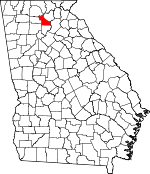
Dawson County, Georgia Basics:


Dawson County Georgia - Government Site

Population: 22,395
Area: 211 square miles
County seat: Dawsonville
Area code(s) in use: 706
Time zone: EST
High school graduate or higher: 86.3%
Bachelor's degree or higher: 23.5%
Median household income: $53,289
Persons in poverty: 13.7%
Home ownership rate: 76.4%
Mean travel time to work: 32.7 minutes


Adjacent counties:
Cherokee  Fannin  Forsyth  Gilmer  Hall  Lumpkin  Pickens  

Find in Georgia

Map of the Dawson County area


Our detail map of Dawson County shows the Dawson County, Georgia boundary lines and other interesting items.

Places in Dawson County, Georgia

  Airports     show all on map

Elliott Field Airport

  Bridges     show all on map

Nix Bridge Access Point, Toto Creek Bridge

  Buildings     show all on map

Big Canoe Fire Department Station 2, Dawson County Courthouse, Dawson County Detention Center, Dawson County Fire Department Station 1, Dawson County Fire Department Station 2, Dawson County Fire Department Station 3, Dawson County Fire Department Station 4, Dawson County Fire Department Station 5, Dawson County Sheriff's Office

  Capes     show all on map

Toto Creek Access Point

  Cemeteries     show all on map

Byrd Cemetery, High Shoals Cemetery, Martin Cemetery, Palmer Cemetery, Salem Church Cemetery, Spriggs Summerour Cemetery

  Churches     show all on map

Amicalola Church, Antioch Church, Bethel Church, Bethel Church, Church of God, Dawsonville Church of God, Goshen Church, Harmony Church, Kilough Church, Lebanon Church, Liberty Church, McKees Chapel, Mount Vernon Church, New Hope Church, Pleasant Grove Church, Pleasant Hill Church, Pleasant Union Church, Sweetwater Church, West Side Tabernacle

  Dams     show all on map

Amicalola Creek Watershed Dam Number Four, Amicalola Creek Watershed Dam Number Three, Amicalola Creek Watershed Dam Number Two, Amicalola Creek Watershed Structure Number One Dam, Amicalola Lake Dam, Etowah River Watershed Dam Number 10, Etowah River Watershed Dam Number 12, Etowah River Watershed Dam Number 13, Etowah River Watershed Dam Number 22, Etowah River Watershed Dam Number 23, Etowah River Watershed Dam Number 24, Etowah River Watershed Dam Number Nine, Etowah River Watershed Structure Number 12 Dam, Fausett Lake Dam, Sunset Hills Lake Dam, Thomas Lake Dam

  Falls     show all on map

Amicalola Falls, Cochrans Falls

  Gaps     show all on map

High Gap, Nimblewill Gap, Sconti Gap

  Locales     show all on map

Blacks Mill, Hightower State Nursery, Licklog, Lumpkin Campground, Thompson Creek Access Point, War Hill Park

  Parks     show all on map

Amicalola Falls State Park, Dawson Forest Wildlife Management Area

  Populated Places     show all on map

Afton, Amicalola, Barrettsville, Dawsonville, Dougherty, Emma, Hubbardsville, Johntown (historical), Juno, Landrum, Lumpkin, McKee, Silver City

  Reservoirs     show all on map

Amicalola Lake, Brice Lake, Bruce Lake, Burt Lake, Fausett Lake, Girl Scout Camp Echo Lake, Head Lake, Kents Lake, Kincaid Lake, Lake Laurel, Overstreet Lake, Reece Lake, Rome Kraft Company Lake, Sunset Hills Lake, Thomas Lake, Vandiver Lake, Wehunt Lake

  Ridges     show all on map

Bethel Ridge, Pettit Ridge

  Schools     show all on map

Black's Mill Elementary School, Dawson County Crossroads School, Dawson County Elementary School, Dawson County High School, Dawson County Middle School, Forest School (historical), Kilough Elementary School, Pine Grove Montessori School, Riverview Middle School, Robinson Elementary School, War Hill Christian Academy, West Side School

  Streams     show all on map

Amicalola Creek, Beaverdam Creek, Black Mill Creek, Burt Creek, Calhoun Creek, Chestatee River, Clear Creek, Cochrans Creek, Fall Creek, Flat Creek, Holly Creek, Huckleberry Branch, Lilly Creek, Little Amicalola Creek, Long Branch, Mill Creek, Palmer Creek, Pigeon Creek, Proctor Creek, Russell Creek, Shoal Creek, Snow Creek, Sweetwater Creek, Thompson Creek, Toto Creek, Yellow Creek

  Summits     show all on map

Amicalola Mountain, Black Mountain, Frosty Mountain, Grogan Mountain, McElory Mountain, Sanderlin Mountain, Wet Mountain

  Valleys     show all on map

Big Savannah,

Dawson County, Georgia Population By Race (2012 estimate)

RacePopulation
WhiteDawson County White population 21,65621,655  
MixedDawson County Mixed population 314313
BlackDawson County Black population 179179
AsianDawson County Asian population 157156
American IndianDawson County American Indian population 9089
Hawaiian & Pacific IslanderDawson County Hawaiian & Pacific Islander population 2222

Additional population tables :
State population table
Georgia population by county