Pickens County, Georgia Basics:


Pickens County Georgia - Government Site

Population: 29,365
Area: 232 square miles
County seat: Jasper
Area code(s) in use: 706 770
Time zone: EST
High school graduate or higher: 80.7%
Bachelor's degree or higher: 22.0%
Median household income: $50,829
Persons in poverty: 11.8%
Home ownership rate: 78.0%
Mean travel time to work: 28.8 minutes

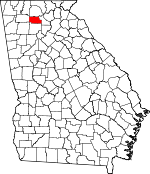
Adjacent counties:
Bartow  Cherokee  Dawson  Gilmer  Gordon  

Find in Georgia

Map of the Pickens County area


Our detail map of Pickens County shows the Pickens County, Georgia boundary lines and other interesting items.

Places in Pickens County, Georgia

  Airports     show all on map

Big Canoe Heliport, Pickens County Airport

  Basins     show all on map

The Basin

  Bays     show all on map

Coffey Cove

  Bends     show all on map

Murphy Bottom

  Buildings     show all on map

Bent Tree Fire Department, Bethany - Salem Volunteer Fire Department Station 1, Bethany - Salem Volunteer Fire Department Station 2, Big Canoe Fire Department Station 1, Big Canoe Fire Department Station 3, Big Canoe Fire Department Station 4, Big Canoe Fire Department Station 5, Dawson County Fire Department Station 6, Georgia State Patrol Troop A Post 28 Jasper, Grandview Volunteer Fire and Rescue, Hinton Community Volunteer Fire Department, Jasper City Hall, Jasper Fire Department, Jasper Police Department, Nelson Police Department, Pickens County Courthouse, Pickens County Emergency Medical Services Station 1, Pickens County Jail, Pickens County Sheriff's Office, Talking Rock Community Volunteer Fire Department, Tate Fire Department

  Cemeteries     show all on map

County Line Cemetery, Home Cemetery, Mountain Cemetery, Norton Cemetery, Sun Rise Memorial Gardens

  Census     show all on map

South Pickens Division (historical), Tate Division (historical)

  Churches     show all on map

Antioch Church, Arbor Hill Church, Ball Creek Church, Bethany Church, Bethel Church, Burnt Mountain Church, Cool Springs Church, Corinth Church, Corinth Church, County Line Church, Cross Roads Church, Crossroads Church, Deer Park Church, Fourmile Church, Freehope Church, Friendship Church, Jasper Baptist Church, Jasper Methodist Church, Jerusalem Church, Kingdom Hall Church, Lebanon Presbyterian Church (historical), Long Swamp Church, Ludville Church, Macedonia Church, Marble Hill Methodist Church, Nelson Methodist Church, New Lebanon Church, Philadelphia Church, Pine Grove Church, Pleasant Hill Church, Pleasant Hill Church, Pleasant View Church (historical), Price Creek Church, Refuge Church, Salem Church, Sharp Top Church, Talking Rock Baptist Church, Tate Methodist Church, Town Creek Church, Unity Church, Yellow Creek Church

  Crossings     show all on map

Ball Creek Ford, Shyers Ford

  Dams     show all on map

Allen Lake Dam, Bent Tree Dam, Bill Teague Lake Dam, Disharoon Lake Dam, Dobbs Lake Dam, Dubose Lake Dam, Ellison-Stifel Lake Dam, Grandview Lake Dam, Griffith Lake Dam, Harrison Lake Dam, Jewell Eaton Lake Dam, Jones Lake Dam, Lake Petit Dam, Long Swamp Creek Watershed Dam Number Eight, Long Swamp Watershed Dam Number 14, Long Swamp Watershed Dam Number 18, Long Swamp Watershed Dam Number Nine, Lower Boswell Lake Dam, Perrow Lake Dam, Sallacoa Watershed Dam Number 48, Sconti Lake Dam, Sequoyah Lake Dam, Sharp Mountain Watershed Dam Number 12, Sharp Mountain Watershed Dam Number 13, Sharp Mountain Watershed Dam Number 14, Sharp Mountain Watershed Dam Number 22, Sharp Mountain Watershed Dam Number 28, Sharp Mountain Watershed Dam Number 31, Sharp Mountain Watershed Dam Number One, Sharp Mountain Watershed Dam Number Two, Talking Rock Watershed Dam Number 13, Talking Rock Watershed Dam Number Four, Talking Rock Watershed Dam Number One, Talking Rock Watershed Dam Number Three, Talking Rock Watershed Dam Number Two, Tillman Lake Dam, Twin Mountain Lakes Dam, Upper Boswell Lake Dam, Upper Twin Mountain Lake Dam

  Falls     show all on map

Padgett Falls

  Gaps     show all on map

Abs Gap, Disharoon Gap, Low Gap

  Hospitals     show all on map

Pickens General Hospital, Piedmont Mountainside Medical Center

  Locales     show all on map

Arrowhead Country Club, Burnt Mountain Baptist Assembly, Cagle Mill (historical), Camp Grandview, Jasper Industrial Park, Pickens County Industrial Park

  Military     show all on map

Fort Newman (historical)

  Parks     show all on map

Jasper City Park, Roper Park

  Populated Places     show all on map

Blaine, Burnt Mountain Estates, Cagle, Carns Mill, Clipper, Daniels, Grandview, Hinton, Holcomb, Jasper, Jerusalem, Keasley (historical), Ludville, Marblehill, McDaniel, Nelson, Rober (historical), Ruden, Sanderstown (historical), Scarecorn, Sweden, Talking Rock, Talmadge, Tate, West Brook

  Post Offices     show all on map

Jasper Post Office, Marble Hill Post Office, Tate Post Office

  Reservoirs     show all on map

Anderson Lake, Anderson Lake, Bill Teague Lake, Cox Lake, Darnell Lake, Disharoon Lake, Dobbs Lake, Dubose Lake, Ellison-Stifel Lake, Georgia Marble Company Lake, Grandview Lake, Griffith Lake, Harrison Lake, Jewell Eaton Lake, Jones Lake, Jones Lake, Jones Lake, Lagomarsino Lake, Lake Petit, Lake Tamarack, Lower Boswell Lake, Martin Lake, Medlin Lake, Mullinax Lake, Odum Lake, Padgett Lake, Perrow Lake, Pittman-Shelton Lake, Reynolds Lake, Sconti Lake, Sequoyah Lake, Stephens Lake, Taylor Lake, Tillman Lake, Twin Mountain Lake, Twin Mountain Lakes, Upper Boswell Lake, Upper Twin Mountain Lake, Van Valkenburgh Lake, Watson Lake

  Schools     show all on map

Appalachian Technical College, Ball Creek School (historical), Federal School (historical), Green School (historical), Harmony Elementary School, Harmony School (historical), Hill City Elementary School, Indian Pine School (historical), Jasper Elementary School, Jasper Middle School, Jasper School, Jasper Seventh Day Adventist School, Ludville High School (historical), Marble Hill School (historical), Philadelphia School (historical), Pickens County Middle School, Pickens High School, Sharp Top School (historical), Tate Elementary School, Town Creek School (historical), Weaver School (historical)

  Streams     show all on map

Ball Creek, Blackwell Creek, Bryant Creek, Cagle Branch, Champion Creek, Cox Creek, Darnell Creek, Disharoon Creek, Eagle Branch, East Branch Long Swamp Creek, Fisher Creek, Fourmile Creek, Hinton Creek, Hobson Creek, Jackson Branch, Little Scarecorn Creek, Mill Creek, Mud Creek, Pettit Creek, Pettit Creek, Polecat Branch, Price Creek, Rock Creek, Scarecorn Creek, Town Creek

  Summits     show all on map

Burnt Mountain, Cagle Mountain, Cox Mountain, Disharoon Mountain, Fuller Mountain, Gee Mountain, Henderson Mountain, Hendrix Mountain, Little McElory Mountain, Mole Mountain, Mount Oglethorpe, Murphy Top, Pack Mountain, Potts Mountain, Rich Mountain, Sassafras Mountain, Sharp Mountain, Sharptop Mountain, Stripling Mountain, Tally Mountain, Toland Mountain, White Mountain

  Towers     show all on map

Tate Lookout Tower, WYYZ-AM (Jasper)

  Valleys     show all on map

Disharoon Cove, Horse Cove, Pettit Cove,

Pickens County, Georgia Population By Race (2012 estimate)

RacePopulation
WhitePickens County White population 28,36728,366  
BlackPickens County Black population 411411
MixedPickens County Mixed population 323323
AsianPickens County Asian population 147146
American IndianPickens County American Indian population 117117
Hawaiian & Pacific IslanderPickens County Hawaiian & Pacific Islander population 00

Additional population tables :
State population table
Georgia population by county