Brantley County, Georgia Basics:


Brantley County Georgia - Government Site

Population: 18,566
Area: 442 square miles
County seat: Nahunta
Area code(s) in use: 912
Time zone: EST
High school graduate or higher: 76.0%
Bachelor's degree or higher: 6.1%
Median household income: $37,374
Persons in poverty: 22.0%
Home ownership rate: 84.0%
Mean travel time to work: 31.3 minutes

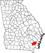
Adjacent counties:
Camden  Charlton  Glynn  Pierce  Ware  Wayne  

Find in Georgia

Map of the Brantley County area


Our detail map of Brantley County shows the Brantley County, Georgia boundary lines and other interesting items.

Places in Brantley County, Georgia

  Airports     show all on map

Brantley County Airport

  Bays     show all on map

Alligator Bays, Briar Bay, Burnt Bay, Seals Bay

  Bends     show all on map

Lower Hog Pen, McIntosh Bend

  Bridges     show all on map

Altman Bridge (historical), Ammons Ferry Bridge (historical), Dowling Bridge (historical), Humpback Bridge, Rattlesnake Bridge (historical), Sand Slough Bridge (historical), Woodwards Bridge (historical)

  Buildings     show all on map

Atkinson Volunteer Fire Department, Brantley County Courthouse, Brantley County Jail, Brantley County Sheriff's Office, Calvary Volunteer Fire Department, Hoboken District Volunteer Fire Department, Hoboken Police Department, Hortense Volunteer Fire Department, Nahunta City Hall, Nahunta Police Department, Nahunta Volunteer Fire Department, Waynesville Volunteer Fire Department

  Cemeteries     show all on map

Ammons Cemetery, Arnett Cemetery, Baxter Cemetery, Bethlehem Cemetery, Daniels Cemetery, Dowling Cemetery, Gibson Cemetery, Grayham Cemetery, Highsmith Cemetery, Jackson Cemetery, Knox Cemetery, Lane Cemetery, Lewis Cemetery, Martin Cemetery, McCool Cemetery, Moore Cemetery, Mount Olive Cemetery, Satilla Cemetery, Spring Hill Cemetery, Thift Cemetery, Thomas Cemetery, Thrift Cemetery, Whitaker Hill Cemetery, Wiggens Cemetery

  Channels     show all on map

Abrams Bluff Cut, Blue Hole Reach, Buzzard Roost Reach, Dark Hole Reach, Five Points Reach, Flat Wood Bluff Reach, Stricklands Reach, Williams Cut

  Churches     show all on map

Atkinson Baptist Church, Bachlott Church, Bethlehem Church, Cascade Church, Christian Fellowship Church, Community Church, East Side Church, First African Church, First Baptist Church, Grace Church, Hickox Baptist Church, High Bluff Church, Hoboken Baptist Church, Hope Chapel, Hortense Church, Hortense Memorial Church, Little Buffalo Church, Little Memorial, Little Oak Grove Church, Little Rock Church, Lulaton Baptist Church, Macedonia Church, Marantha Church, Mount Calvary Church, Mount Zion Church, Nahunta United Methodist Church, New Hope Church, New Hope Church, Oak Grove Church, Oak Grove Church (historical), Oak Hill Church, Old Time Church, Palmetto South Church, Pierce Chapel, Pilgrims Rest Church, Pleasant Valley Church, Raybon Church, Raybon Church, Riverside Church, Sandhill Church, Sloan Hill Church, Smyrna Church, Southside Baptist Church, Trinity Church, Twin Rivers Church, Waynesville Church

  Cliffs     show all on map

Abrams Bluff, Baxter Bluff, Buies Bluff, Clay Bluff, Flanders Shady Bluff, Flatwoods Bluff, Higans Bluff, Honey Bluff, Jumping Bluff, Lord King Bluff, Oquin Bluff, Radfords Bluff, Robinson Hammock Bluff, Strickland Bluff

  Crossings     show all on map

Dowling Ford

  Dams     show all on map

Deerwood Lake Dam, Lake Floree Dam, Strickland Lake Dam

  Guts     show all on map

Dead River, Deep Slough, Gator Slough, Gum Slough

  Islands     show all on map

Baker Island, Boat Landing Island, Briar Island, Buck Island, Corncob Island, Cowhouse Island, Flowers Island, Robinson Hammock, White Oak Hammock, Zetser Hammock

  Lakes     show all on map

Abrahams Lake, Atkinson Lake, Basin Lake, Baxter Lake, Bonnet Lake, Bonnett Lake, Buck Lake, Christmas Lake, Cypress Lake, Ditch Lake, Doe Lake, Dreading Lake, Drurys Lake, Felton Lake, Finger Lake, Forked Lake, Gator Lake, Heads Lake, Johns Pond, Julia Lake, Kings Lake, Long Lake, Long Lake, Pollys Lake, Round Lake, Sandy Lake, Santee Lake, Spring Lake, Spring Lake, Teston Lake

  Locales     show all on map

Ammons Ferry, Buies Camp (historical), Davidson Landing, Dowlings Ferry Landing, Dubberly Landing, Kitchens Landing, Linda Plantation, Mouth of the Branch Landing, Mouth of the Swamp Landing, Rosin Landing, Spell Landing, Strickland Landing, Strickland Landing, Tabernacle Camp Ground

  Populated Places     show all on map

Atkinson, Bachlott, Big Oak, Browntown, Burton Terrace, Fendig, Fort Mudge, Happy Landing, Hickox, Hoboken, Hortense, Lulaton, Manson (historical), Nahunta, Needmore, Popwellville, Prosperity, Raybon, Salter, Schlatterville, Trudie, Waynesville

  Post Offices     show all on map

Hortense Post Office, Nahunta Post Office, Waynesville Post Office

  Reservoirs     show all on map

Deerwood Lake, Lake Floree, Lake Wendi, Strickland Lake

  Schools     show all on map

Brantley County High School, Brantley County Middle School, Davidson School (historical), Hoboken Elementary School, King School (historical), Little Satilla School (historical), Menor School (historical), Nahunta Elementary School, Pine Bloom School (historical), Riverview School (historical), Strickland School (historical), Waynesville Elementary School, White School (historical)

  Streams     show all on map

Back Branch, Big Branch, Big Creek, Buffalo Creek, Church House Branch, Dead River, Dix Branch, Harper Branch, Little Buffalo Creek, Little Satilla River, McIntosh Creek, Mill Branch, Mill Creek, Mill Creek, Mineral Branch, Page Branch, Satilla Creek, Seals Branch, South Prong Big Creek, Taylor Branch, Taylor Branch, Well Branch

  Swamps     show all on map

Alligator Swamp, Beaver Dam Swamp, Caney Bay, Caney Branch, Dark Thick, Fort Camp Branch, Fox Head, Indian Swamp, Indian Swamp, Jardine Bay, Kings Bay, Kings Suck, Kneeknocker Swamp, Little Okefenokee Swamp, Maple Suck, Maul Hammock Prairie, Millpond Branch, Oak Suck, Raulerson Swamp, Satilla Swamp, Still Lake, Tiger Bay

  Towers     show all on map

WACL-FM (Waycross), WBGA-FM (Waycross), WBSG-TV (Brunswick)

  Valleys     show all on map

Happy Hollow,

Brantley County, Georgia Population By Race (2012 estimate)

RacePopulation
WhiteBrantley County White population 17,58217,582  
BlackBrantley County Black population 613612
MixedBrantley County Mixed population 260259
American IndianBrantley County American Indian population 7474
AsianBrantley County Asian population 3737
Hawaiian & Pacific IslanderBrantley County Hawaiian & Pacific Islander population 00

Additional population tables :
State population table
Georgia population by county