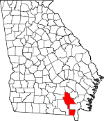
Ware County, Georgia Basics:


Ware County Georgia - Government Site

Population: 35,798
Area: 892 square miles
County seat: Waycross
Area code(s) in use: 912
Time zone: EST
High school graduate or higher: 81.1%
Bachelor's degree or higher: 14.0%
Median household income: $34,700
Persons in poverty: 23.6%
Home ownership rate: 67.4%
Mean travel time to work: 19.6 minutes


Adjacent counties:
Atkinson  Bacon  Baker (FL)  Brantley  Charlton  Clinch  Coffee  Columbia (FL)  Pierce  

Find in Georgia

Map of the Ware County area


Our detail map of Ware County shows the Ware County, Georgia boundary lines and other interesting items.

Places in Ware County, Georgia

  Airports     show all on map

Bivins Airport, Memorial Hospital Heliport, Pafford Field, Waycross-Ware County Airport

  Bays     show all on map

Poke Bay, Stevens Bay

  Buildings     show all on map

Baptist Village Nursing Home, Georgia State Patrol Troop I Post 22 Waycross, J Olan Jones Health Care Center, Regional Emergency Medical Services, Riverside Nursing Home, Satilla Care Center, Satilla Regional Rehabilitation Institute, Ware County Courthouse, Ware County Fire Rescue Station 1 Industrial Park, Ware County Fire Rescue Station 10 Bickley, Ware County Fire Rescue Station 2 Manor, Ware County Fire Rescue Station 3 Southeast, Ware County Fire Rescue Station 4 Emerson Park, Ware County Fire Rescue Station 5 Boggy Bay, Ware County Fire Rescue Station 6 Dixie Union, Ware County Fire Rescue Station 7 Millwood, Ware County Fire Rescue Station 8 Peeble Hill, Ware County Fire Rescue Station 9 Waresboro, Ware County Jail, Ware County Sheriff's Office, Ware Manor Nursing Home, Ware State Prison, Waycross City Hall, Waycross Fire Department Station 1 Headquarters, Waycross Fire Department Station 2, Waycross Fire Department Station 3, Waycross Health and Rehabilitation Center, Waycross Police Department, Waycross Public Library

  Canals     show all on map

Cedar Hammock Canal, City Drainage Canal, Suwannee Canal, Suwannee River Sill

  Capes     show all on map

Fivemile Point, Mary Howell Point, Seldom Seen Point

  Cemeteries     show all on map

Bagley Cemetery, Barner Cemetery, Bennett Cemetery, Carter Cemetery, Chauncey Cemetery, Crestwood Memorial Gardens, Greenlawn Cemetery, Hazzard Hill Cemetery, Kettle Creek Cemetery, Lott Cemetery, Moore Cemetery, Mount Pleasant Cemetery, Oakland Cemetery, Red Oak Cemetery, Walden Cemetery, Waresboro Cemetery

  Census     show all on map

Deenwood Census Designated Place, Manor-Waycross Division (historical), Sunnyside Census Designated Place

  Churches     show all on map

Albany Avenue Baptist Church, Antioch Baptist Church, Astoria Church, Austin Chapel Christian Methodist Episcopal Church, Bible Baptist Church, Bickley Church, Big Bethel Freewill Baptist Church, Booth Church, Brooks Church, Brunel Street Church of God, Calvary Baptist Church, Camp Branch Church, Central Baptist Church, Church of Christ, Church of Christ, Church of Christ Written, Church of God, Church of God, Church of God of Prophecy, Church of God of Prophecy, Church of God of Wahoma, Church of the Nazarene, Community Holiness Church, Congregational First Born Church, Cornerstone Church of God, Crawford Street Baptist Church, Deenwood Baptist Church, Dixie Union Church, Eagles Nest Church, El Bethel Church, Emmanuels International Cathedral Church, Ezekiel Church, Faith Temple Church, First Assembly of God Church, First Baptist Church, First Born Church, First Born Sanctified Church, First Christian Church, First Church of the Nazarene, First Evangelical Methodist Church, First Methodist Church, First Presbyterian Church, Freedom Community Church, Friendship Baptist Church, Friendship Church, Full Gospel Assembly Church, Full Gospel Mission, Gaines Chapel African Methodist Episcopal Church, Gilchrist Methodist Church, Glad Tidings Church, Gospel Tabernacle Church, Grace Chapel, Grace Church, Grace Episcopal Church, Greater Mount Zion African Methodist Episcopal Church, Greater Saint Paul Missionary Baptist Church, Hargrave Chapel, Haywood Church, Hebardville Baptist Church, Hebardville Methodist Episcopal Church, Hephzibah Church, Hosanna Church of Christ, House of Prayer, Indian Mound Church, Jamestown Baptist Church, Jamestown United Methodist Church, Jordan Church, Kettle Creek Church, King Solomon Methodist Episcopal Church, Liberty Church, Liberty Free Will Baptist Church, Life Christian Center, Little Bethel African Methodist Episcopal Church, Macedonia Baptist Church, Manor Chapel, Manor Church, Mason Temple Church of God, Millwood Church, Morton Avenue Baptist Mission, Mount Green Church, Mount Olive Chapel Church of Christ, Mount Olive Church, Mount Pleasant Church, Mount Pleasant Missionary Baptist Church, Mount Zion Methodist Church, New Hope Baptist Church, New Mount Pleasant Baptist Church, New Pleasant Grove Baptist Church, New Prospect Church, Newbern Church, Oak Grove Church, Okefenokee Church, Old Ruskin Church, Olivet Baptist Church, Pebble Hill Church, Piedmont Okefenokee Baptist Church, Pillar of Ground Sanctified Church, Pine Grove Church, Pine Valley Church, Pine View Church, Pineview Baptist Church, Piney Grove Church, Pittman Chapel, Power House of Faith, Providence Church, Saint Ambrose Episcopal Church, Saint James Baptist Church, Saint Johns Baptist Church, Saint Josephs Roman Catholic Church, Saint Lukes African Methodist Episcopal Church, Saint Pauls Baptist Church, Saint Pauls Number 3 Church, Saint Peters Baptist Church, Saint Peters Missionary Baptist Church, Salem Church, Salem Church, Second Baptist Church, Seventh Day Adventist Church, Shiloh Baptist Church, Southside Baptist Church, Sunnyside Church, Sweat Memorial Church, Telmore Church, The Church of Jesus Christ of Latter Day Saints, The Greater Mount Olive Church, Trinity Methodist Church, True Foundation Church of God, University Boulevard Church of God, Victory Drive Church of God, Victory Methodist Church, Waering Community Church, Ware Baptist Church, Waresboro First United Methodist Church, Waycross Gospel Tabernacle, Westside Assembly of God Church, Westside Church, Whitehall Free Will Baptist Church, Williams Chapel, Winona Park United Methodist Church, Woodard Chapel, Young Memorial Chapel, Zachary Holliness Church, Zenith Church, Zion Hill Church, Zion Rest Primitive Baptist Church

  Dams     show all on map

Gerbin Lake Dam, Herrin Pond Dam, King 0 Lee Lake Dam, Laura S Walker State Park Lake Dam, Shriners Club Lake Dam

  Flats     show all on map

Smokehouse Jam, The Pocket

  Forests     show all on map

Dixon Memorial State Forest

  Gaps     show all on map

Goose House Gap

  Hospitals     show all on map

Satilla Regional Hospital, Ware County Health Center

  Islands     show all on map

Bay Island, Bear Island, Bearpen Island, Big Bay Island, Big Cypress Camp Island, Black Hammock, Black River Island, Blackjack Island, Briar Island, Broomstraw Island, Bugaboo Island, Burnt Island, Bush Island, Cane Break Island, Charles Island, Cravens Hammock, Croaker Island, Deer Gallus Island, Gainey Island, Galberry Island, Hillard Island, Hog Gallus Island, Hog Island, Hog Island, Honey Island, Honey Scrub Island, Horseshoe Island, Huckleberry Island, Huckleberry Island, Jack Island, Lingerfelt Island, Little Island, Little Pine Island, Little Scrub Island, Long Island, Middle Strange Island, Mims Island, Mitchell Island, Negro Camp Island, New Island, Number One Island, Palmetto Island, Pine Island, Pine Island, Pine Island, Pope Island, Round Timber Island, Sandy Island, Scrub Island, Soldiers Camp Island, Strange Island, Suwannee Creek Islands, The Island, Well Island, Wheel of Fortune Island, Wildcat Island, Wolf Island

  Lakes     show all on map

Altman Pond, Big Cypress Lake, Big Lake, Blackjack Lake, Boone Lake, Buck Lake, Burnett Lake, Buzzards Roost Lake, Cooter Lake, Dan Dunkins Lake, District Pond, Double Lake, Gannet Lake, Gator Head Pond, Jack Lake, Lake Lila, Little Cooter Lake, Long Lake, Lower Lake, Mandy Lake, Maul Hammock Lake, Monkey Lake, Mud Lake, Ohio Lake, Piney Woods Lake, Pittmans Pond, Seagrove Lake, Skull Lake, Suwannee Lake, Tar Lake, Turkey Scratch Lake, Walter Lakes, Water Bay, Wide Slough, Winona Lake

  Locales     show all on map

Barbers Landing, Bugaboo Landing, Coffee Bay Rest Shelter, Eightmile Post, Fifteenmile Post, Georgia Lions Camp for the Blind, Hatcher Point Mall Shopping Center, Moody Dairy Farm, Okefenokee Church Camp, Okefenokee Fairgrounds, Satilla Square Shopping Center, Taylors Landing, The Lakes Golf Couse at Laura S Walker, Twelvemile Post, Waycross Water Pollution Control Plant

  Military     show all on map

Waycross Army Air Field (historical)

  Parks     show all on map

Folks Park, Heritage Center, Laura S Walker State Park, Memorial Stadium, Monroe Park, Newton Field, Voight Field, Waycross Historic District, Waycross State Forest, Winona Park

  Populated Places     show all on map

Astoria, Beach, Bickley, Bolen, Braganza, Crawley, Crews Crossing, Deenwood, Dixie Union, Emerson Park, Fairfax, Garlington Heights Housing Project, Glenmore, Hasty, Haywood, Hebardville, Hinson Crossing, Hopkins, Jamestown, Lakeside Mobile Home Park, Manor, Millwood, Needham, Pine Valley, Ruskin, Sand Hill, Sappville, Satilla Village Mobile Home Park, Skullhead, Sunnyside, Talmo, Three Points, Viviani, Wahoma, Waltertown, Waresboro, Waycross, Winona Park

  Post Offices     show all on map

Waycross Post Office

  Reservoirs     show all on map

Baptist Village Lake, Gerbin Lake, Herrin Pond, King 0 Lee Lake, Laura S Walker Lake, Monroe Pond, Shriners Club Lake

  Ridges     show all on map

Moonshine Ridge

  Schools     show all on map

Alice Street School, Ava Street High School, Bailey Street School, Center High School, Center Junior High School, Central Avenue High School, Colley Street Vocational School, Crawford Street School, Daffodil School, Gilchrist Park School, Hazzard Hill School, Isabella Street School, Manor School, Memorial Drive Elementary School, Morton Avenue School, Okefenokee Technical College, Quarterman Street School (historical), Reidsville School, Saint Josephs Academy, Southside Christian School, Southwood School, University of Georgia, Wacona School, Ware County High School, Ware County Junior High School, Ware County Learning Center, Waycross Vocational School, Waycross Ware Technical School, Waycross-Ware County Junior College, Williams Heights School

  Streams     show all on map

Alligator Creek, Bailey Branch, Barbers Run, Bear Belly Strand, Big Alligator Creek, Black River, Botherment Branch, Breakfast Branch, Buck Branch, Camp Branch Creek, Cane Creek, Cane Creek, Caney Branch, Coon Branch, Cox Creek, Davis Branch, Double Branches, Dryden Creek, Fullwood Creek, Green River Run, Gum Swamp, Hog Creek, Kettle Creek, Lees Branch, Little Alligator Creek, Little Suwannee Creek, Martha Branch, Mill Branch, Perch Creek, Piney Bay, Seventeen Mile River, Stalsby Creek, Stewart Branch, Sugar Branch, Suwannee Creek, Tom Thumb Creek, Tuten Creek, Water Oak Creek

  Swamps     show all on map

Bennett Bay, Big Bay, Blackjack Prairie, Boggy Bay, Buck Prairie, Burned Out Prairie, Chesser Prairie, Cloughs Bay, Cowhouse Prairie, Cox Prairie, Cribb Bay, Double O Bay, Duboise Bay, Footlog Bay, Gator Wallow, Gooding Bay, Grand Prairie, Hendrix Bay, Honey Island Prairie, Huckleberry Bay, Huckleberry Bay, Huckleberry Bay, Long Pond, Mizell Prairie, Musket Bay, Okefenokee Swamp, Pike Swamp, Pittman Bay, Pittman Bay, Rice Pond, Roundabout Swamp, Sapp Prairie, Stallard Bay, Steedley Bay, Strange Island Prairie, Tom Thumb Bay

  Towers     show all on map

WAYX-AM (Waycross), WWUF-FM (Waycross), WXGA-TV (Waycross), WXVS-FM (Waycross)

  Trails     show all on map

Indian Trail,

Ware County, Georgia Population By Race (2012 estimate)

RacePopulation
WhiteWare County White population 24,16424,163  
BlackWare County Black population 10,59610,596
MixedWare County Mixed population 537536
AsianWare County Asian population 286286
American IndianWare County American Indian population 179178
Hawaiian & Pacific IslanderWare County Hawaiian & Pacific Islander population 3635

Additional population tables :
State population table
Georgia population by county