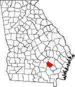
Bacon County, Georgia Basics:


Bacon County Georgia - Government Site

Population: 11,174
Area: 259 square miles
County seat: Alma
Area code(s) in use: 912
Time zone: EST
High school graduate or higher: 71.8%
Bachelor's degree or higher: 8.9%
Median household income: $33,557
Persons in poverty: 17.4%
Home ownership rate: 68.3%
Mean travel time to work: 26.5 minutes


Adjacent counties:
Appling  Coffee  Jeff Davis  Pierce  Ware  

Find in Georgia

Map of the Bacon County area


Our detail map of Bacon County shows the Bacon County, Georgia boundary lines and other interesting items.

Places in Bacon County, Georgia

  Airports     show all on map

Bacon County Airport

  Buildings     show all on map

Alma - Bacon County Fire Department, Alma Police Department, Bacon County Courthouse, Bacon County Jail, Bacon County Sheriff's Office, Bacon Probation Detention Center, New Lacey Volunteer Fire Station, Sessoms Volunteer Fire Station, Taylor Town Volunteer Fire Station, Ware Volunteer Fire Station, Warnock Volunteer Fire Station

  Cemeteries     show all on map

Antioch Cemetery, Big Creek Cemetery, Camp Ground Cemetery, Carters Chapel Cemetery, Corinth Cemetery, Damascus Cemetery, Douglas Chapel Cemetery, Elisabeth Chapel Cemetery, Friendship Cemetery, Harrison Cemetery, Harrison Cemetery, Holton Cemetery, Holton Cemetery, Jesus Cemetery, Johnsons Cemetery, Lees Chapel Cemetery, Mercer Cemetery, Mims Cemetery, New Hope Cemetery, Patterson Cemetery, Pine Grove Cemetery, Pine Lawn Cemetery, Pine Level Cemetery, Rockingham Cemetery, Rose Hill Cemetery, Springfield Cemetery, Stewart Cemetery, Sweat Cemetery, Taylor Cemetery, Taylors Cemetery, Ten Mile Cemetery, Turner Cemetery, Unity Cemetery, Wesley Chapel Cemetery, Wesley Chapel Cemetery

  Census     show all on map

Rockingham Census Designated Place

  Churches     show all on map

Abundant Life Family Worship Center, Adventist Church, Alma Church, Alma Methodist Church, Antioch Church, Bead Street Holiness Church, Big Creek Church, Campground Church, Carter Chapel, Church of God, Church of God of Prophecy, Church of Jesus, Coffee Church, Corinth Church, Corinth Church, Damascus Church, Douglas Chapel, East Side Baptist Church, Elizabeth Chapel, Evangelistic Temple, First African Baptist Church, First Baptist Church of Alma, First Church of the Nazarene, First Community Church, Friendship Church, Friendship Church, Gospel of the Kingdom Church, Grace Chapel, Holton Church, Jesus Church, Lee Chapel, Liberty Church, Mims Chapel, Mount Pleasant Church, Mount Pleasant Church, Mount Sinai Church of Jesus Christ, New Hope Church, New Lacy Church of God, New Union Church, Oak Hill Church, Old Pine Grove Church, Pine Level Church, Restored Mission Church, Saint James Church, Saint Raymonns Church, Southside Church of God, Springfield Methodist Church, Tenmile Creek Church, Unity Church, Wesley Chapel, Wesley Chapel, Westside Congregational Methodist Church, Zion Chapel Baptist Church

  Dams     show all on map

Aldridge and Eason Lake Dam, Anderson Lake Dam, Bar-O-Ranch Lake Dam, Bryant and Futch Lake Dam, Johnson Lake Dam, Johnson Lake Dam, Johnsons Lake Dam, Jones Lake Dam, Lake Lure Dam, Lee Lake Dam, Mckinnon Lake Dam, Mullis Lake Dam, Tanner Lake Dam, Whitley Lake Dam

  Hospitals     show all on map

Bacon County Hospital

  Locales     show all on map

Alma Water Pollution Control Center, Blueberry Plantation Golf and Country Club

  Populated Places     show all on map

Alma, Coffee, Guysie, Lambright, Lees Trailer Park, New Lacy, Rockingham, Sessoms

  Post Offices     show all on map

Alma Post Office, Coffee Post Office (historical), Guysie Post Office (historical), New Lacy Post Office (historical), Rockingham Post Office (historical)

  Reservoirs     show all on map

Aldridge and Eason Lake, Anderson Lake, Bar-O-Ranch Lake, Bryant and Futch Lake, Johnson Lake, Johnson Lake, Johnson Lake, Johnsons Lake, Jones Lake, Lake Lure, Lee Lake, Mckinnon Lake, Mullis Lake, Tanner Lake, Whitley Lake

  Schools     show all on map

Bacon County Elementary School, Bacon County High School, Bacon County Middle School

  Streams     show all on map

Bear Branch, Big Branch, Briar Creek, Brushy Creek, Little Creek, Mill Branch, Rigdon Branch, Tenmile Creek

  Towers     show all on map

WKXH-FM (Alma), WULF-AM (Alma),

Bacon County, Georgia Population By Race (2012 estimate)

RacePopulation
WhiteBacon County White population 9,1299,129  
BlackBacon County Black population 1,7881,787
MixedBacon County Mixed population 134134
AsianBacon County Asian population 6767
American IndianBacon County American Indian population 4544
Hawaiian & Pacific IslanderBacon County Hawaiian & Pacific Islander population 1111

Additional population tables :
State population table
Georgia population by county